Browse Listings in Europe > British Isles > British Counties

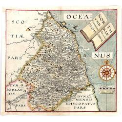
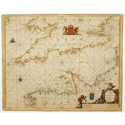
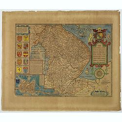
Northumbria, Cumberlandia et Dunelmensis Episcopatus.
Showing the most northern part of England.Mercator was born in Rupelmonde in Flanders and studied in Louvain under Gemma Frisius, Dutch writer, astronomer and mathematici...
Place & Date: Amsterdam, 1630
Selling price: $150
Sold in 2020
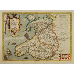
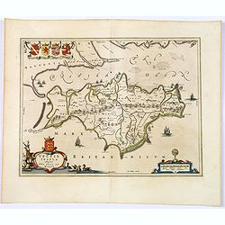
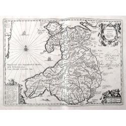
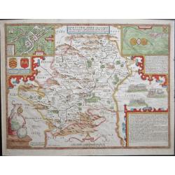
Cambriae Typus..
Ancient map of Wales, prepared by Humphrey Lhuyd. With fine cartouche, part of a compass-rose and a sea monster.
Place & Date: Amsterdam 1633
Selling price: $500
Sold

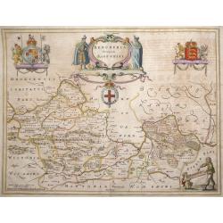
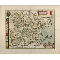
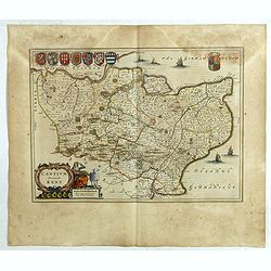
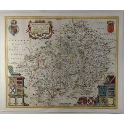
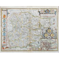
Warwicum..
Nice map of south-eastern England. Includes London, Salisbury, Oxford, Cambridge, Leicester and Norwich and the Isle of Wight. Strapwork title cartouche and scale of mile...
Place & Date: Amsterdam 1634
Selling price: $150
Sold
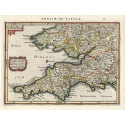
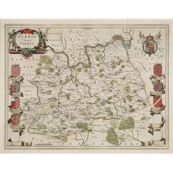
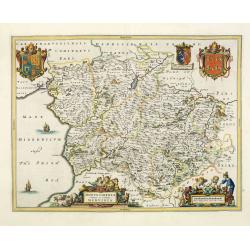
Cornubia, Devonia,..
Nice map Southwest England and South Wales. Decorated with a small strapwork title cartouche. Latin text on verso.
Place & Date: Amsterdam 1634
Selling price: $120
Sold

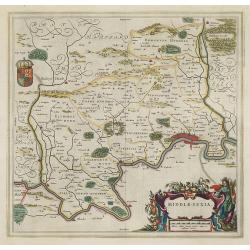
Middle-Sexia.
A finely engraved map of the area north of London, from the most important Dutch map publishers of the 17th century.
Place & Date: Amsterdam 1635
Selling price: $205
Sold
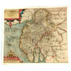
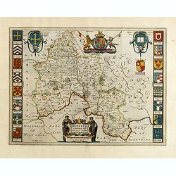
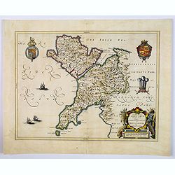
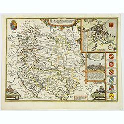
Cumbria Sive Cumberlandia Quae Olim par Brigantum.
A pleasing map of Cumberland from “Camden’s Britannia”. The 'Britannia' was the first publication that contained a complete set of individual county maps of England...
Place & Date: London, 1610-1637
Selling price: $85
Sold in 2016
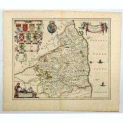
Northumbriae Comitatus, Olim Sedes Otadinorum.
An attractive map of Northumberland based on the first survey of England and Wales by Christopher Saxton and published in William Camden's “BRITANNIA” (London: 1607-...
Place & Date: London, 1610-1637
Selling price: $145
Sold in 2016
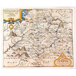
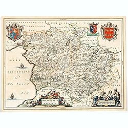
Montgomery Comitatus Qui Osim Pars Ordovicum.
Fine copper engraving of the county of Montgomery in England. The title is in a strapwork cartouche. Prepared and engraved by William Kip and William Hole based on Chris...
Place & Date: London, 1637
Selling price: $45
Sold in 2016

Buckingha Comitatus, in quo olim insederunt Cattieuchlani.
A fine early map of Buckinghamshire engraved by William Hole after Christopher Saxton. From the 1607 or 1637 edition of Camden's 'Britannia'. Very detailed, extending fro...
Place & Date: London, 1637
Selling price: $42
Sold in 2020
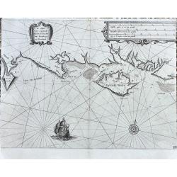
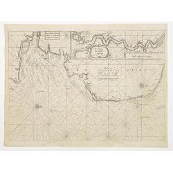
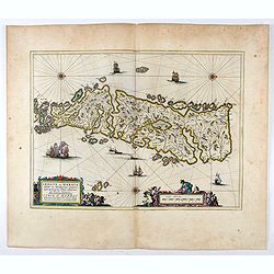
De Custen van Engelandt tuschen de droochte van Weembrugh en Poortlandt
Rare sea-chart from Blaeu's Zeespiegel. It shows the area around the Isle of Wight, from Weymouth and the Isle of Portland to Selsey and Chichester, including Poole, Sout...
Place & Date: Amsterdam, ca. 1638
Selling price: $200
Sold in 2022

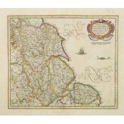
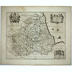
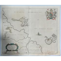
Eboracum, Lincolnia, Derbia, Staffordia, Notinghamia..
Showing the north-eastern part of England. Ornamental title cartouche in the upper right corner. Embellished with a vessel and a sea monster.
Place & Date: Amsterdam 1642
Selling price: $150
Sold

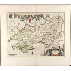
Westmorlandia Lancastria, Cestria, Caernarvan, Denbigh..
Showing the north-western part of England, including the Island of Man, Liverpool, Blackpool, etc.Embellished with ornamental title cartouche and a vessel.
Place & Date: Amsterdam 1642
Selling price: $120
Sold in 2009

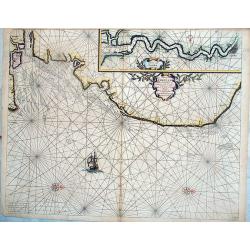
A general Plott and description of the Fennes..
Fine map depicting the area north of Cambridge, up to King's Lynn. West to the top.
Place & Date: Amsterdam, 1642
Selling price: $250
Sold in 2020
Eboracum, Lincolnia, Derbia, Staffordia, Notinghamia..
Showing the north-eastern part of England.
Place & Date: Amsterdam, 1642
Selling price: $360
Sold in 2009

Cambriae Typus.
Ancient map of Wales, prepared by Humphrey Lhuyd. With fine cartouche, part of a compass-rose and a sea monster.
Place & Date: Amsterdam 1639-1644
Selling price: $460
Sold

Lot of 5 maps of the English counties.
Lot of 5 maps of the English counties.
Place & Date: Amsterdam 1639-1644
Selling price: $500
Sold

A general Plott and description of the Fennes..
Fine map depicting the area north of Cambridge, up to King's Lynn. West to the top. °
Place & Date: Amsterdam, 1639-1644
Selling price: $65
Sold in 2011
A general Plott and description of the Fennes..
Fine map depicting the area north of Cambridge, up to Kings Lynn. West to the top.
Place & Date: Amsterdam 1639-1644
Selling price: $230
Sold in 2008

Cambriae Typus.
Ancient map of Wales, prepared by Humphrey Lhuyd. With fine cartouche, part of a compass-rose and a sea monster.No text on verso. From a French composite atlas.Read more ...
Place & Date: Amsterdam, 1639-1644
Selling price: $90
Sold in 2018

Essexia Comitatus.
Double-page attractive map of the country of Essex. Showing London in the lower left corner, and other towns such as West Ham, East Ham, Waltham stow, South end on Sea, H...
Place & Date: Amsterdam, 1645
Selling price: $220
Sold in 2011

De Noort Cust van Engelandt / tusschen Crammer en / de Revier van / Nicastle. 12
Father Jacob (1600-73) and son Arnold Colom (1624-68) were highly successful publishers of nautical charts. ' Vyerige Colom', in Dutch, French and English editions, sea-a...
Place & Date: Amsterdam, 1645
Selling price: $375
Sold in 2011
Oxonium Comitatus, Vulgo Oxford shire.
Double-page map of the county of Oxford on the Thames River. This English county map is highly decorative with figurative title cartouche of two scholars. Royal arms and ...
Place & Date: Amsterdam, 1645
Selling price: $600
Sold in 2015
Vectis Insula. Anglice The Isle of Wight.
A beautifully engraved map seventeenth-century map of the Isle of Wight, just off the southern English coast. Features a nice decorative title cartouche in lower left cor...
Place & Date: Amsterdam, 1645
Selling price: $150
Sold in 2018

Glocestria Ducatus, Vulgo Glocestershire.
Double-page map of the county of Gloucester. Shows cities of Bristol, Tewkesbury, Cheltenham, and Stroud. Decorative title cartouche lower right corner of shepherds and t...
Place & Date: Amsterdam, ca. 1645
Selling price: $35
Sold in 2020
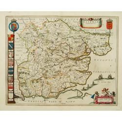
Comitatus Dorcestria, sive Dorsettia, Vulgo Anglice Dorset shire.
Double-page map of Dorsetshire county with decorative title and scale cartouches, six family coats of arms and two blank shields at bottom left.
Place & Date: Amsterdam, ca. 1645
Selling price: $50
Sold in 2020

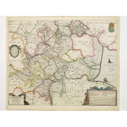
Wigorniensis Comitatus et Comitatus Warwicensis, nec non Coventrae libertas, Worcester, Warwic shire. And the Liberty of Coventre.
A double-page general map of the English counties of Warwickshire and Worcestershire with other towns such as Birmingham, Coventry, Leamington, Nuneaton, Kenilworth, Rugb...
Place & Date: Amsterdam, ca. 1645
Selling price: $40
Sold in 2019

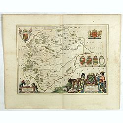
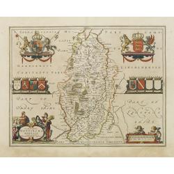
Leicestrensis Comitatus. Leicester shire.
Double-page map of the English county of Leicestershire. Decorative figurative and allegoric title cartouche with many heraldic family coat of arms on the bottom left por...
Place & Date: Amsterdam, ca. 1645
Selling price: $95
Sold in 2020

Radnoria Comitatus. Radnor shire.
Double-page map of Radnorshire county, East of Wales. It is richly embellished with figurative title and scales cartouches, as well as coats of arms and royal arms.
Place & Date: Amsterdam, ca. 1645
Selling price: $34
Sold in 2020

Denbigiensis Comitatus et Comitatus Flintensis, Denbigh et Flintshire.
Double-page map of Denbigshire and Flintshire, Wales with ornamental cartouches and armorials.
Place & Date: Amsterdam, ca. 1645
Selling price: $33
Sold in 2020

Westmoria Comitatus: Anglice Westmorland.
A double-page map of Westmorland county in the northwest of England. Two very decorative cartouches with putti and figures display the title and scale in the two lower co...
Place & Date: Amsterdam, 1645
Selling price: $65
Sold in 2020

Mervinia et Montgomeria Comitatus.
A decorative Welsh counties map by Jan Jansson, published in Amsterdam during the first half of the seventeenth century. It shows the mid-western Welsh counties of Merion...
Place & Date: Amsterdam, ca 1645
Selling price: $70
Sold in 2020
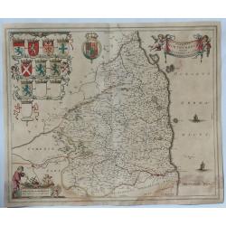
Comitatus Northumbria, Vernacule Northumberland. . .
A double-page map of Northumberland county with a decorative title cartouche and scale bar, eight family coats of arms and three blank shields at left. Superbly engraved ...
Place & Date: Amsterdam, ca 1645
Selling price: $200
Sold in 2023
Episcopatus Dunelmensis. Vulgo The Bishoprike of Durham.
Fine double-page map of the bishopric and university city of Durham with two title and scale cartouches, and two impressive coat of arms upper left and right corners. Fre...
Place & Date: Amsterdam, 1646
Selling price: $90
Sold in 2020

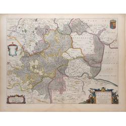
Middlesexiae cum Hertfordiae Comitatu: Midlesex & Hertfordshire.
Published in Novus Atlas sive Theatrum orbis Terrarum.The map has Decorative title and scale cartouches with peasants and livestock, upper right and lower centre respecti...
Place & Date: Amsterdam, 1646
Selling price: $550
Sold

Episcopatus Dunelmensis. Vulgo The Bishoprike of Durham.
Exquisite black and white map of Durham with two fine title and scale cartouches, and two impressive coat of arms upper left and right corners.
Place & Date: Amsterdam, 1646
Selling price: $54
Sold in 2019

Oxonium Comitatus, Vulgo Oxford shire.
Double-page map of the county of Oxford on the Thames River. This English county map is highly decorative with figurative title cartouche of two scholars. Royal arms and ...
Place & Date: Amsterdam, 1647
Selling price: $500
Sold in 2012

'LEICESTRENSIS COMITATUS' Leicestershire
An attractive, finely engraved and hand colored copperplate 17th century map of Leicestershire. German text edition with two Royal crests, fine cartouches for title and s...
Place & Date: Amsterdam, 1647
Selling price: $170
Sold in 2017
Penbrochia Comitatus et Comitatus Caermaridunum
Attractive map of the country of Pembrokeshire in UK by J. Blaeu. From a Dutch edition of "Atlas Maior" in beautiful color. br>With 13 coats of arms, one car...
Place & Date: Amsterdam, 1648
Selling price: $310
Sold in 2008

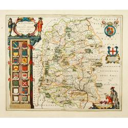
HUNTINGDONENSIS COMITATUS, HUNTINGTON SHIRE
A highly attractive and finely copper plate engraved 17th century map This example bears French text to the verso and the usual excellent quality coloring.
Place & Date: Amsterdam, 1648
Selling price: $250
Sold in 2013

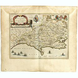
Hantonia Sive Southantonensis Comitatus Vulgo Hantshire
A very attractive Blaeu map of Hampshire. The map is embellished with royal coat of arms, and also of earls of Winchester and Southampton. Latin text on verso.
Place & Date: Amsterdam, 1648
Selling price: $425
Sold in 2013
Wiltopnia sive comitatus Wiltoniensis, Anglis Wilshire.
A fine copy of this famous and decorative map of Wiltshire. 16 shields, two left blank underneath the decorated cartouche at top left. Two more shields at right, secondar...
Place & Date: Amsterdam 1650
Selling price: $250
Sold
Essexia comitatus.
A fine copy of this famous and decorative map of Essex. Title banner, scale cartouche with three putti. Royal Arms, Arms of England and A panel displaying seven coats of ...
Place & Date: Amsterdam 1650
Selling price: $330
Sold
Pascaerte Vertoonende de Mont Vande Teemse en Voort de Custe van Engelandt tot Crammer.
Fine map depicting the English shores between Cromer in the Norfolk and North Foreland in Kent. West to the top.Additional title: Les Costes d?Engleterre depuis le Voorla...
Place & Date: Amsterdam 1650
Selling price: $300
Sold
Bercheria vernacule. . . (Barkshire)
‘Bercheria vernacule’ - Barkshire by Joannes Blaeu. A very decorative map, with armorials and escutcheons.
Place & Date: Amsterdam, 1650
Selling price: $300
Sold in 2013
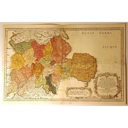
Anciens Royaumes de Mercie et East Angles. . .
Ancient Kingdoms of Mercia and East Anglia. This is a striking map showing the ancient Saxon kingdoms of Mercia and East Anglia including the counties and shires of Chest...
Place & Date: Paris, 1654
Selling price: $119
Sold in 2017
Surria Vernacle Surrey.
Highly decorative showing the seven coats of arms of the Surrey Earls all in full color. Shows towns of London and Kingston on the Thames River, Guildford, Croydon, Richm...
Place & Date: Amsterdam, 1658
Selling price: $725
Sold in 2009
Essexia Comitatus
Outstanding attractive map of the country of Essex in UK. Showing London in the lower left corner. color is gold heightened, with king coats of arms and family coats of a...
Place & Date: 1660
Selling price: $600
Sold in 2008
Cambriae Typus Auctore Humfredo Lhuydo.
Fantastic early map of Wales with sailing ships, a sea monster, compass rose, several putti, and an ornamental title cartouche. The map shows numerous towns, rivers, hill...
Place & Date: Amsterdam, ca. 1660
Selling price: $92
Sold in 2018
Comitatus Caernarvoniensis, Vernacule Carnarvonshire. Et Mona insula Vulgo Anglessey.
The detailed and decorative Blaeu double-page map of Caernarvon & Anglesey, with a decorative title cartouche depicting a farmer with his harvest, royal armorials and...
Place & Date: Amsterdam, ca 1660
Selling price: $55
Sold in 2019
Rutlandia Comitatus. Rutland Shire.
One of the most decorative maps of the county Rutlandshire, with armorials, a scale cartouche and a rustic title cartouche It is richly embellished with an elaborate titl...
Place & Date: Amsterdam, 1661
Selling price: $45
Sold in 2020
Cantium Vernacule Kent.
of the county of Kent. The map is embellished with the Royal Arms, the crest and feathered crown of the Prince of Wales. The decorative title and scale cartouche features...
Place & Date: Amsterdam, 1661
Selling price: $120
Sold in 2020
Montgomeria Comitatus et Comitatus Mervinia.
Double-page map of Montgomery shire and Merionethshire counties, Eastern and Western Wales. With elaborate title cartouche, distance scale and coats of Arms, including th...
Place & Date: Amsterdam, 1662
Selling price: $200
Sold in 2013
Nottinghamshire.
Map of the county of Nottinhgamshire from the spanish edition of the Atlas Major of Blaeu. Very nice original coloring with heightening of gold in the cartouches and cre...
Place & Date: Amsterdam 1662
Selling price: $150
Sold
Middle-sexia.
Double-page map of the old Middlesex County, including a marvelous depiction of London on the Thames in the lower right corner. Decorative cartouche and coat of arms. Lat...
Place & Date: Amsterdam, 1662
Selling price: $390
Sold in 2009

Middle-sexia.
Double-page map of the old Middlesex County, including a marvelous depiction of London on the Thames in the lower right corner. Decorative cartouche and coat of arms. Lat...
Place & Date: Amsterdam, 1662
Selling price: $600
Sold in 2024
Pascaerte van Engelant vant Voorland tot aen Blakeney, waer in te sien is de mont vande Teemse. . .
Rare chart showing the West coast of England and the mouth of the River Thames. The upper right inset shows the Thames from London into the North Sea. With decorative flo...
Place & Date: Amsterdam, 1662
Selling price: $290
Sold in 2018
Wigorniensis Comitatus et Comitatus Warwicensis, nec non Coventrae libertas.
A beautifully, detailed 1662 French Edition of the Blaeu copper engraved map of Worcestershire and Warwickshire. The map provides excellent topographic details on cities,...
Place & Date: Amsterdam, 1662
Selling price: $130
Sold in 2019
Lincolnia Comitatus. Anglia Lincoln-Shire.
A fine old color example of Blaeu's map of Lincoln, from his “Atlas Maior”, one of the most sought-after atlases by collectors and institutions today due to the atten...
Place & Date: Amsterdam, 1662
Selling price: $150
Sold in 2019
Comitatus Northumbria Vernacule Northumberland.
A fine very decorative old color map of Northumberland from the 1662 publication of Blaeu's “Atlas Major", one of the most sought-after atlases by collectors and i...
Place & Date: Amsterdam, 1662
Selling price: $115
Sold in 2019
Insula Sacra vulgo Hosy Iland et Farne.
Map of Holy Island and Farne off the coast of Northumberland, in north east England, from the 1662 publication of Blaeu's “Atlas Major" one of the most sought-afte...
Place & Date: Amsterdam, 1662
Selling price: $160
Sold in 2019
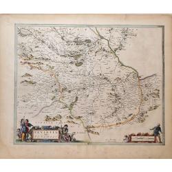
Teviotia Vulgo Tivedail
Beautiful map of Teviotdale, a region of Southeast Scotland, by Joan Blaeu. Shows the cities Selkirk and Kelso, along with the mountains, rivers and forests of the region...
Place & Date: Amsterdam, 1664
Selling price: $110
Sold in 2010
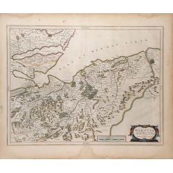
Moravia Scotiae provincial. . .
Beautiful map of Moray, a region of Northeast Scotland, by Joan Blaeu. Shows the towns of Inverness, Forres and Elgin, along with the mountains, rivers and forests of the...
Place & Date: Amsterdam, 1664
Selling price: $110
Sold in 2010
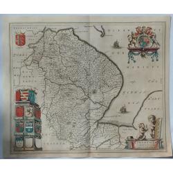
Regiones Inundata Infinibus comitatus Norfolcia, Suffolcia, Cantabrigia, Huntingtonia, Northhamtonia, et Lincolnia
Beautiful map of the East Anglia region of England, showing the counties of Norfolk, Suffolk, Cambridge, Huntington, Northampton and Lincoln, along with the mountains, ri...
Place & Date: Amsterdam, 1664
Selling price: $330
Sold in 2010
Montgomeria comitatus et comitatus Mervinia.
A beautifully engraved and presented map of the mid Welsh counties of Merionethshire and Montgomeryshire, as published in the Dutch edition of the Atlas Major.In addition...
Place & Date: Amsterdam, ca 1664
Selling price: $55
Sold in 2020
Leogus et Haraia, insulae ex Aebudarum numero . . .
This is an uncommon and lovely map of Lewis and Harris in the Western Isles. The map is oriented with west at top and is richly embellished with decorative cartouches sur...
Place & Date: Amsterdam, 1664
Selling price: $180
Sold in 2020
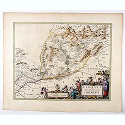
Lidalia el Lidisdalia Regio.
The region that this map covers is north-western England and the Scotland border. Solwat Forth is located in the lower left corner. The Hermitage Castle, built in 1244, i...
Place & Date: Amsterdam, 1664
Selling price: $100
Sold in 2021
The West Ridinge of Yorkeshyre with The most famous and fayre Citie Yorke described 1610.
Speed's important and decorative map of Yorkshire. The county is shown with many place names, hundreds, rivers, hills, forests, and much more. It features several coats o...
Place & Date: London, ca. 1665
Selling price: $285
Sold in 2017
Het Canaal tusschen Engeland en Vranciick.
An eye-catching of the Channel.Pieter Goos (ca. 1616-1675) was one of the most important cartographer, engraver, publisher and print seller of Amsterdam. His widow conti...
Place & Date: Amsterdam, 1673
Selling price: $1500
Sold in 2015
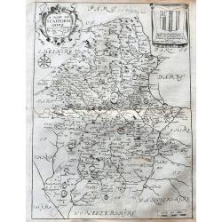
A Mapp of Staffordshire with its hundreds.
An early and attractive map of Staffordshire, published in Richard Blome's 'Britannia'. Very detailed with many place names, rivers, and hills. Decorated with the title c...
Place & Date: London, 1673
Selling price: $16
Sold in 2020
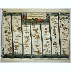
The Continuation of the Road from London to the Lands-end
This map is from John Ogilby's 'Britannia', published between 1675 and 1698. It is a landmark in the mapping of England and Wales. Its unique format constituted the first...
Place & Date: London, 1675
Selling price: $250
Sold in 2012
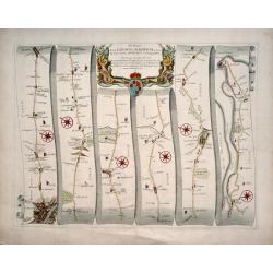
The Road from London to Harwich .
First edition. This strip map is from the "Britannia" by John Ogilby, published in 1675 identified by no sheet number. It is entitled " The Road from Londo...
Place & Date: London, 1675
Selling price: $165
Sold in 2014
NORFOLK A COUNTIE FLORISHING & POPULOUS DESCRIBED AND DEVIDED WITH THE ARMES OF SUCH NOBLE FAMILIES AS HAVE BORNE THE TITLES THEREOF.
John Speed's fine map of county published in London by Bassett & Chiswell 1676. The map is embellished with an inset town plan of Norwich, the royal arms with support...
Place & Date: London 1676
Selling price: $400
Sold in 2013
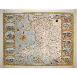
Wales
This is a spectacular and sought after map of Wales by John Speed. Considered to be the most decorative map of the country ever published. The work contains twelve large ...
Place & Date: London, ca. 1676
Selling price: $2400
Sold
The Countye Palatine with the most ancient citie described.
The excellent county map of Cheshire, first published in Speed's “Theatre of Empire” in 1611, this is the 1676 edition with the Bassett & Chiswell imprint. The ma...
Place & Date: London, 1676
Selling price: $400
Sold in 2020
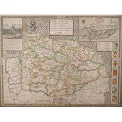
Herefordshire described. . .
The 1676 edition map of Herefordshire by John Speed, and published by Bassett & Chiswell in London. A decorative English county map, embellished with strapwork title ...
Place & Date: London, 1676
Selling price: $100
Sold in 2020
The Countie and Citie of Lyncolne. . .
John Speed's attractive map of Lincolnshire. Published at the back end of the seventeenth century by Basset & Chiswell in London. The left of the map features a town ...
Place & Date: London, 1676
Selling price: $60
Sold in 2021
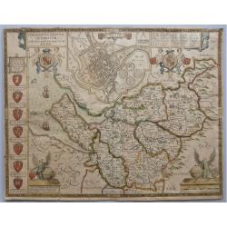
'Hartford Shire described, The situations of Hartford and the most ancient towne S.Albons with such memorable actions as have happened'
Full title as it appears at the top of the map: 'Hartford Shire described, The situations of Hartford and the most ancient towne S.Albons with such memorable actions as h...
Place & Date: London, 1676
Selling price: $475
Sold in 2020
Essex, devided into Hundreds...
Speed's famous map of Essex. From London until Harwich. With an inset plan of Colchester. Richly decorated with coats of arms and seals, sailing ships, a sea-monster, and...
Place & Date: London, 1676
Selling price: $280
Sold in 2023
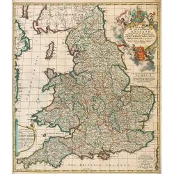
A New Mapp of the Kingdome of England, Representing the Princedome of Wales, and other Provinces, Cities, Market Towns, with the roads from Town to Town.
Interesting road map with English text by Visscher of England and Wales, focusing on the distances between cities and market towns. The map was published by Visscher, but...
Place & Date: Amsterdam, 1688
Selling price: $835
Sold in 2009

Nieuwe Pas-kaert vande Oost Kust van Engeland en Schotland. . .
A delightful Dutch maritime chart that includes the east coast of England, running from Berwick in Northumberland, southwards to Burlington in Yorkshire. A nice inset map...
Place & Date: Amsterdam, 1690
Selling price: $300
Sold in 2019