Browse Listings in America > North America
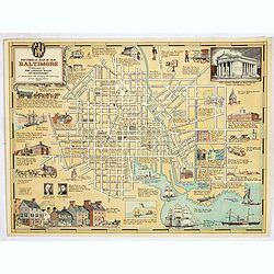
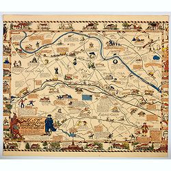
Historical Map of Old Baltimore.
A lovely, detailed map of the old 'downtown' area of Baltimore, with its streets well laid out, with numerous small vignette pictures illustrating historic events and ill...
Place & Date: Baltimore, 1954
Selling price: $100
Sold in 2019
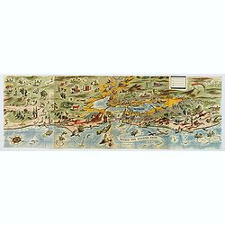
Within the Golden Gate. A survey of the History, Resources, and Points of Interest. . .
A nicely produced brochure of the area around San Francisco, with a delightful fully colored pictorial map of the area as the front and back covers for the brochure. The...
Place & Date: San Francisco, 1955
Selling price: $195
Sold in 2020
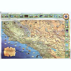
A Pictorial Map of Southern California and adjacent areas.
A beautiful folding map of Southern California, taking the geography from San Francisco to San Diego and the Mexican border. As well as plenty of physical map detail, the...
Place & Date: Los Angeles, ca. 1960
Selling price: $85
Sold in 2017
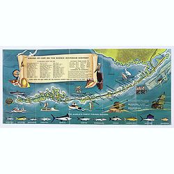
Florida Keys & Key West. . .
A folding map (brochure) advertising the many attractions of the Florida Keys and Key West. Map. The map is illustrated by a number of cartoonish vignettes of local wildl...
Place & Date: Miami, aftrer 1960
Selling price: $50
Sold in 2020
![[Golden Gate Bridge San Francisco]](/uploads/cache/46709-250x250.jpg)
[Golden Gate Bridge San Francisco]
Signed lithograph view of the Golden Gate Bridge in San Francisco, by E.R.
Place & Date: ca. 1960
Selling price: $100
Sold in 2020
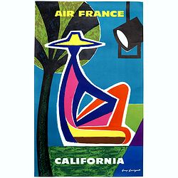
California.
"CALIFORNIA" advertising poster for AIR France, design by Guy Georget (1911-1992).His “California” poster from 1963 flirts with cubism. The white outline ar...
Place & Date: Paris, S.A.Courbet, 1963
Selling price: $400
Sold in 2020

New York.
Perhaps one of the greatest cartographic feats of all time, this 1963 'bird's eye view' map of New York City was the first such produced for almost a century. Amazingly, ...
Place & Date: New York, 1963
Selling price: $160
Sold in 2018

New York.
Perhaps one of the greatest cartographic feats of all time, this 1963 'bird's eye view' map of New York City was the first such produced for almost a century. Amazingly, ...
Place & Date: New York, 1963
Selling price: $200
Sold in 2019
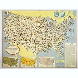
Carte Illustree des Etats-Unis d'Amerique Principaux produits, resources regionales, et particularites physiques.
A decorative French map of the United States' main products, regional resources and physical features. The map is covered with many small pictorial vignettes highlighting...
Place & Date: Washington D.C., ca. 1965
Selling price: $55
Sold in 2018
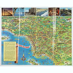
A Pic-Tour map of Southern California.
A highly colorful and attractive pictorial travel map of southern California, from Santa Barbara, southward to San Diego & Tijuana. Major streets, highways, attractio...
Place & Date: San Francisco, ca 1965
Selling price: $145
Sold in 2019
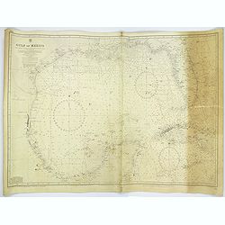
Gulf of Mexico.
A large sea chart of the Gulf of Mexico 'from Admiralty Charts and US Government charts, corrected to 1966'. (In fact there are corrections up until 1977).Chart extent is...
Place & Date: London, 1882 corrected to 1966
Selling price: $95
Sold in 2017
The Main Line. A Historical Map of Ye Outlying Regions . . .
A pictorial map depicting the geography, history and landmarks of the Main Line, the informal name for a group of western suburbs of Philadelphia, Pennsylvania. The area ...
Place & Date: Philadelphia, 1975
Selling price: $67
Sold in 2020

Crossroads of Empire. Early Maps of Texas and the Southwest 1513 - 1900
Poster made for the exhibit 'Crossroads of Empire: Printed Maps of Texas and the Southwest, 1513-1900' at the Amon Carter Museum, Fort Worth" June 11–July 26, 1981...
Place & Date: Fort Worth, 1981
Selling price: $60
Sold in 2021
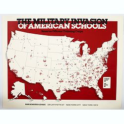
The Military Invasion of American Schools.
An interesting offset colour printed lithograph map / poster of the United States that is liberally covered in symbols of either black triangles or red circles, both high...
Place & Date: New York, 1984
Selling price: $70
Sold in 2023

Ronald Reagan.
Original drawing representing a caricature of Ronald Reagan.Born in 1958, Jan Op De Beeck was elected in 2003 as 'World's Best Caricaturist' by the Professional cartoonis...
Place & Date: Belgium, 1987
Selling price: $200
Sold
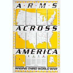
Arms Across America Waging Third World War.
This is a striking propaganda map, created by The War Registers League, founded 100 years ago in the U.S. it continues today as a secular, pacifist organization dedicated...
Place & Date: New York, 1989
Selling price: $100
Sold in 2023
![La Florida [with] Guastecan [with] Peruviae Auriferae Regionis Typus.](/uploads/cache/83483-250x250.jpg)
La Florida [with] Guastecan [with] Peruviae Auriferae Regionis Typus.
Three-in-one map from a Ortelius' "Theatrum Orbis Terrarum" Atlas published in Antwerp 1572/1598, Dutch language edition. Showing: Florida and the south, after...
Place & Date: Antwerp, 1572/98
Selling price: $600
Sold in 2019
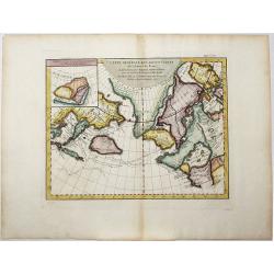
Carte Generale des Decouvertes de l'Amiral de Fonte, . . (Explorers)
An interesting map of the NW Coast of America and the NE Coast of Asia, based upon Jefferys map of 1768. Prior to Cook's 1st Voyage, the English, French and Russians were...
Place & Date: Paris, 1770ca
Selling price: $106
Sold in 2020
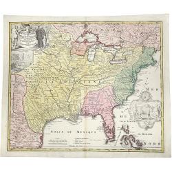
Amplissimae Regionis MISSISSIPI Seu Proninciae Ludovicianae.
A striking hand-colored example of Homann's map of the Course of the Mississippi River, based upon the reports of Hennepin, who explored the upper Mississippi and Great L...
Place & Date: Nuremberg, ca 1720
Selling price: $1000
Sold in 2019

Carte des Lacs du Canada..
Scarce edition of this accurate map showing the all the Great Lakes in the traditional Bellin configuration.Kershaw does not mention this state with in lower right corner...
Place & Date: Amsterdam, 1773.
Selling price: $500
Sold in 2014
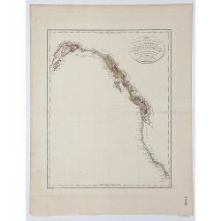
Carte de la partie de la Cote nord-ouest de l' Amerique.
A detailed and rare map of the Gulf of Alaska, British Columbia, and south to St.Francisco. Prepared by Edward Roberts after information by George Vancouver and engraved ...
Place & Date: Paris, ca. 1800
Selling price: $180
Sold in 2017
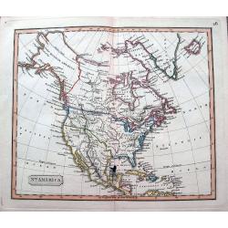
North America.
An interesting steel engraved map showing Mexico reaching until Mendocino and Utah Lake! Locates Texas, Cabo San Lucas, New Madrid in Missouri, etc. Names Indian nations,...
Place & Date: Anon, ca 1820?
Selling price: $47
Sold in 2018
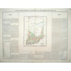
Carte Géographique .. Indiana.
\"Detailed map of Indiana. From J.A. Buchon, \"\"Atlas Gégraphique Statistique, historique et chronologique des deux Ameriques et des isles adjacentes; tr...
Place & Date: Paris 1825.
Selling price: $120
Sold

Land District North of Red River in the Sate of Louisiana.
An unusual map from an American land survey report, surveyed in 1823 by Maxfield Ludlow, and ordered by The House of Commons in 1827. It shows the Mississippi River with ...
Place & Date: London, 1828?
Selling price: $26
Sold in 2018

Washinga Sahba's Grab.../ Tombeau de Wachinga Sahba.../ Washinga Sahba's Grave on Blackbird's Hill.
Aquatint from: 'Reise in das innere Nord-America in den Jahren 1832-1834' by Prince Maximilian of Wied-Neuwied, after paintings by Karl Bodmer, engraved by Lucas Weber, p...
Place & Date: London, 1842
Selling price: $200
Sold in 2016

A set of 15 humorous prints. 1846, 1857, 1858, 1862, 1863, 1864, 1866. 1882, 1896. All with American, Civil War, Oregon Treaty and Abraham Lincoln interest
A set of 15 humorous prints. 1846, 1857, 1858, 1862, 1863, 1864, 1866. 1882, 1896. All with American, Civil War, Oregon Treaty and Abraham Lincoln interest.Mostly engrav...
Place & Date: London 1846 - 1896
Selling price: $55
Sold in 2015

Raccolta del Cotone.
Attractive view on a cotton plantation. The scene is explained through a key index on top.It represents black people at work for the Europeans' supplying of cotton and il...
Place & Date: [No Title]
Selling price: $70
Sold