Browse Listings in America > North America
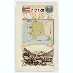
Alaska / Costume del S. Salvador.
An unusual item. It is a nice colored chromolithograph map of Alaska, with a few place names, a coat of arms and the American flag, together with a small view of Sitca be...
Place & Date: Milano, 1905
Selling price: $22
Sold in 2019

Barneget Inlet to Absecon Inlet. New Yersey . Coast Chart No. 122.
A sea chart of part of the coast of New Yersey with Atlantic City and the mouth of the Mullica river with Great Bay.
Place & Date: Washington, 1906
Selling price: $50
Sold in 2018

sea chart of part of the coast of New Yersey. From Sandy hook to Barneget Inlet. New Yersey . Coast Chart No. 121.
A sea chart of part of the coast of New Yersey.
Place & Date: Washington, 1906
Selling price: $50
Sold in 2020
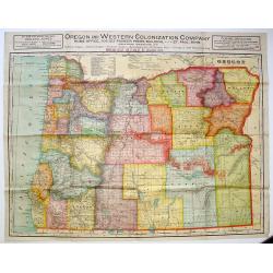
Oregon and Western Colonization Company map of Oregon.
Very detailed Oregon And Western Colonization Company real estate map in color. The Willamette Valley and Cascade Mountain Wagon Road Company sold their 800,000 land gran...
Place & Date: Chicago, ca. 1909
Selling price: $175
Sold in 2013
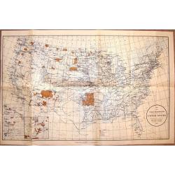
Map Showing Indian Resevations Within the Limits of the United States.
Fine, large chromolithograph map showing American Indian Reservations after the turn of the century. It was compiled under the direction of the Honorable R.G. Valentine, ...
Place & Date: Wahington, 1910
Selling price: $70
Sold in 2016
![[Official US Government Document.]](/uploads/cache/48154-250x250.jpg)
[Official US Government Document.]
An official US government printed document, completed in manuscript. An attractive engraved broadside, completed in manuscript and signed by President William Howard Taft...
Place & Date: Washington D.C., 1910
Selling price: $300
Sold in 2022

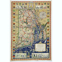
Topographic view of Valley Forge. During the Encompment of Washington's Army in the winter of 1777-78.
Fine and rare topographical view of Valley Forge, showing the area at the time of Washington's Encampment in December 1777 and January 1778. A reduced sized copy of the o...
Place & Date: Philadelphia, 1911
Selling price: $250
Sold in 2020

Bird's eye view of Boston Harbor and South Shore to Provincetown showing steamboat routes. Price 10 cents.
Lithographic bird's eye town-view view of Boston harbour, Massachusetts and the surrounding region (including Cape Cod). With a numbered key (1-35) on inside of the cover...
Place & Date: Boston, Union News Company, South Station, ca. 1912
Selling price: $210
Sold in 2011
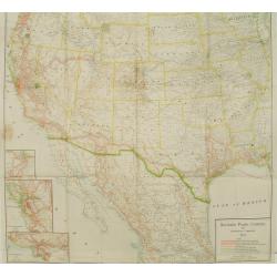
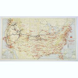
Southern Pacific Company and proprietary companies.
Map of the routes of the Southern Pacific Railway throughout California with connections to other parts of the United States. With inset maps of Los Angeles, San Francisc...
Place & Date: Chicago & New York, 1915
Selling price: $30
Sold
Map showing Great Northern Railway System..
Map of the rail way routes of the railway systems throughout the northern parts of the United States.
Place & Date: Chicago & New York, 1915
Selling price: $150
Sold

State of Arizona compiled chiefly from the official records of the General Land Office with supplemental data from other map making agencies, under the direction of I.P. Berthrong, chief of drafting division, G.L.O.
The map was compiled by Daniel P.O'Hare under the supervision of I. P. Berthrong, Drafting Division Chief of the General Land Office. It was printed by the Columbia Plano...
Place & Date: Washington D.C., 1921
Selling price: $100
Sold in 2015

Erie Harbor and Presque Isle, Pennsylvania.
A US nautical chart of Erie Harbour and Presque Island in Pennsylvania - an eight updated edition (1924) to an original survey first undertaken in 1901 of the northern an...
Place & Date: United States, 1924
Selling price: $8
Sold in 2021
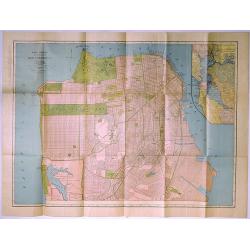
Rand McNally Standard Map of San Francisco.
A pleasing map of the city of San Francisco, California, issued by the Rand McNally and Company in 1927. It covers the entire city from Fort Point and Presidio Park as fa...
Place & Date: Chicago, 1927
Selling price: $10
Sold in 2019

Pictorial map of New York City. . .
A lovely town plan of New York City, published by Arthur Crosby services, in 1928, on behalf of the Chase National Bank, which is very interesting, as the published date ...
Place & Date: New York, 1928
Selling price: $375
Sold in 2018
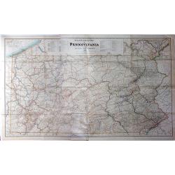
Steam Railroad Map of Pennsylvania.
A huge map, Issued by the Public Service Commission in 1929, by J. W. Clement Co., Matthews-Northrup Works, Buffalo, N. Y. This large folding map is the late twenties ver...
Place & Date: Buffalo, 1929
Selling price: $130
Sold in 2017

A Map of Old Boston in the Commonwealth of Massachusetts.
A quaint and charming pictorial map of the tourist sites of downtown Boston as seen in 1929. Buildings and streets are clearly marked. This map was drawn by Charles R. Ca...
Place & Date: Boston, 1929
Selling price: $300
Sold in 2020

Friendly Service Map of the Commonwealth of Ohio.
A scarce map of the Commonwealth of Ohio, published by the Mobile Oil Company between the wars. A fun and informative map with numerous topical small illustrations, place...
Place & Date: Ohio, ca 1930
Selling price: $75
Sold in 2019

The Central part of Boston, Massachusetts, showing transportation lines of the Boston Elevated Railway.
A very nice folding plan of central Boston, highlighting transportation lines within the city during the 1930's.The two lower corners, and the entire top margin of the ma...
Place & Date: Boston, ca. 1930
Selling price: $105
Sold in 2017

The Cape Ann Trail.
A large folding map of the Cape Ann trail in Massachusetts. The map has 28 red numbered points of reference, which correspond to the small, uncolored vignettes that frame...
Place & Date: Gloucester, 1930
Selling price: $55
Sold in 2018

The Creole City of New Orleans.
A large, decorative poster extolling the virtues of the all American city of New Orleans. It extends from Lake Pontchartrain and Spanish Fort, southwards, passing the Bay...
Place & Date: New Orleans, 1930
Selling price: $155
Sold in 2018

A Map of Olde Boston prepared in commemoration of the Tercentary of Massachusetts Bay Colony 1630-1930.
A double-sided brochure produced to commemorate the 300 year foundation of the Colony of Massachusetts Bay. On one side is the map of Boston, surrounded by contemporary a...
Place & Date: Boston, 1930
Selling price: $60
Sold in 2018

The House Beautiful Old Massachusetts Map of Houses showing their location, type and other information. . .
color pictorial map of Massachusetts, with decorative border showing those oldest homes from colonial and revolutionary houses. Designed by Raymond Lufkin (1899–1978) w...
Place & Date: 1930
Selling price: $90
Sold in 2020

North West Louisiana Fish and Game Preserve.
A different map of the North West Louisiana Fish & Game Preserve in 1931. Produced in New Orleans by the Department of Conservation commissioner, Robert S. Maestri. D...
Place & Date: New Orleans, 1931
Selling price: $6
Sold in 2017
Military Map of the United States / Illustrated Gettysburg Battlefield Map.
The first map of this pair is an attractive general map of the USA Issued by the Union Pacific Railroad during WWII, pictorially showing all the Naval Bases, Army Camps, ...
Place & Date: Chicago, 1942 - Pennsylvannia, 1932
Selling price: $40
Sold in 2019
Sante Fe Railway Map - (No Title)
A rare pictorial promotional map published by the Santa Fe Railroad, by B.C. Broome in 1932.The map promotes the lines "Couriercar Indian-detours", stating &quo...
Place & Date: Sante Fe, 1932
Selling price: $80
Sold in 2019
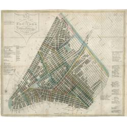
Map of the City of New York with the Latest Improvements
A very fine example of an early edition of Phelps's pocket map of New York City. Dated 1832, this antique map of New York City is one of only a few known examples from th...
Place & Date: New York, 1932
Selling price: $1200
Sold in 2023

Indian episodes of New York State, land of the Hodenosaunee .
Pictorial map of New York State, illustrated and noted throughout with small vignettes of historic locations and events, landmarks, rivers, Native Americans in various ac...
Place & Date: New York, 1935
Selling price: $170
Sold in 2016

Indian Episodes of New York.
A drama-story map of the Empire State, displaying Indian episodes of New York, a lithograph produced by the Rochester Museum of Arts and Sciences.The map is surrounded by...
Place & Date: Rochester, 1935
Selling price: $160
Sold in 2017
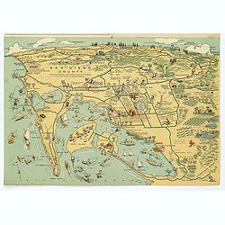
Map of San Diego California City and County.
A lovely folding map of San Diego on one side, and a smaller map of San Diego County on the reverse, together with a comprehensive street index, nice attractive pictorial...
Place & Date: San Diego, ca. 1935
Selling price: $85
Sold in 2017
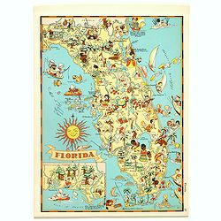
Florida.
Pictorial map of Florida, from the famous illustrator, Ruth Taylor White and published in "Our USA: A Gay Geography".Ruth Taylor White was among the most prolif...
Place & Date: Boston, Little, Brown and Company, 1935
Selling price: $90
Sold in 2017
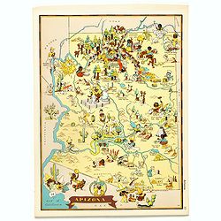
Arizona.
Pictorial map of Arizona, from the famous illustrator, Ruth Taylor White and published in "Our USA: A Gay Geography".Ruth Taylor White was among the most prolif...
Place & Date: Boston, Little, Brown and Company, 1935
Selling price: $35
Sold in 2017

Alaska.
Pictorial map of Alaska, from the famous illustrator, Ruth Taylor White and published in "Our USA: A Gay Geography".Ruth Taylor White was among the most prolifi...
Place & Date: Boston, Little, Brown and Company, 1935
Selling price: $40
Sold in 2018

Michigan.
Pictorial map of Michigan, from the famous illustrator, Ruth Taylor White and published in "Our USA: A Gay Geography".Ruth Taylor White was among the most proli...
Place & Date: Boston, Little, Brown and Company, 1935
Selling price: $85
Sold in 2018
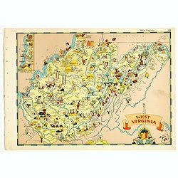
West Virginia.
Pictorial map of West Virginia, from the famous illustrator, Ruth Taylor White and published in "Our USA: A Gay Geography".Ruth Taylor White was among the most ...
Place & Date: Boston, Little, Brown and Company, 1935
Selling price: $60
Sold in 2018

Washington.
Pictorial map of Washington, from the famous illustrator, Ruth Taylor White and published in "Our USA: A Gay Geography".Ruth Taylor White was among the most pro...
Place & Date: Boston, Little, Brown and Company, 1935
Selling price: $115
Sold in 2019
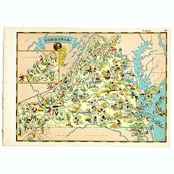
Virginia.
Pictorial map of Virginia, from the famous illustrator, Ruth Taylor White and published in "Our USA: A Gay Geography".Ruth Taylor White was among the most proli...
Place & Date: Boston, Little, Brown and Company, 1935
Selling price: $60
Sold in 2018
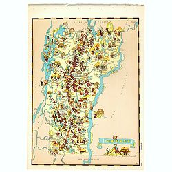
Vermont.
Pictorial map of Vermont, from the famous illustrator, Ruth Taylor White and published in "Our USA: A Gay Geography".Ruth Taylor White was among the most prolif...
Place & Date: Boston, Little, Brown and Company, 1935
Selling price: $60
Sold in 2018
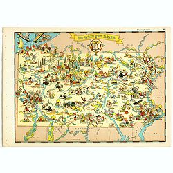
Pennsylvania.
Pictorial map of Pennsylvania, from the famous illustrator, Ruth Taylor White and published in "Our USA: A Gay Geography".Ruth Taylor White was among the most p...
Place & Date: Boston, Little, Brown and Company, 1935
Selling price: $75
Sold in 2018
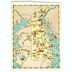
Delaware.
Pictorial map of Delaware, from the famous illustrator, Ruth Taylor White and published in "Our USA: A Gay Geography".Ruth Taylor White was among the most proli...
Place & Date: Boston, Little, Brown and Company, 1935
Selling price: $75
Sold in 2018
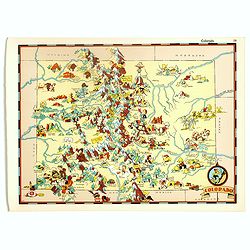
Colorado.
Pictorial map of Colorado, from the famous illustrator, Ruth Taylor White and published in "Our USA: A Gay Geography".Ruth Taylor White was among the most proli...
Place & Date: Boston, Little, Brown and Company, 1935
Selling price: $55
Sold in 2017

Texas.
Pictorial map of Texas, from the famous illustrator, Ruth Taylor White and published in "Our USA: A Gay Geography".Ruth Taylor White was among the most prolific...
Place & Date: Boston, Little, Brown and Company, 1935
Selling price: $100
Sold in 2018
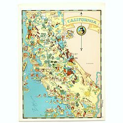
California.
Pictorial map of California, from the famous illustrator, Ruth Taylor White and published in "Our USA: A Gay Geography".Ruth Taylor White was among the most pro...
Place & Date: Boston, Little, Brown and Company, 1935
Selling price: $95
Sold in 2017
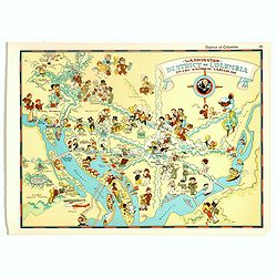
Washington, District of Columbia, the national capital.
Pictorial map of Washington, District of Columbia, the national capital, from the famous illustrator, Ruth Taylor White and published in "Our USA: A Gay Geography&qu...
Place & Date: Boston, Little, Brown and Company, 1935
Selling price: $75
Sold in 2017
Map of San Diego California City and County.
A lovely folding recreational map of San Diego City & County, Compiled & Copyrighted by Lowell E. Jones. Map of San Diego on one side, and a smaller map of San Di...
Place & Date: San Diego, ca. 1935
Selling price: $80
Sold in 2017
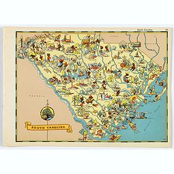
South Carolina.
A fun, humorous, whimsical map of South Carolina by Ruth Taylor White.
Place & Date: Boston, ca 1935
Selling price: $45
Sold in 2020
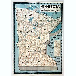
Minnesota invites you to Live-Work-Play in the Playground of 10,000 Lakes.
An attractive three color pictographic map of Minnesota, that folds down to a pamphlet, with numerous color and black and white illustrations on the verso. On the map, sm...
Place & Date: Saint Paul, 1935
Selling price: $55
Sold in 2020
Rhode Island and Providence Plantations. . .
An attractive and uncommon map of the smallest US state of Rhode Island, or officially known as Rhode Island and Providence Plantations. The map is surrounded by a number...
Place & Date: Rhode Island, 1936
Selling price: $130
Sold in 2017

Maine. Its Recreation and History.
A pictorial map of the American state of Maine. This large map is littered with small icons and vignettes as to the various activities that can be had within the state, e...
Place & Date: Augusta, ca. 1936
Selling price: $65
Sold in 2018
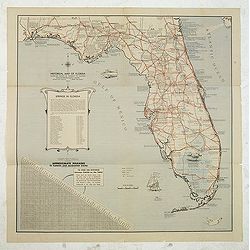
Historical map of Florida showing points of interest to visitors.
Historical map of Florida showing points of interest to visitors, issued by Florida State Department of Agriculture, in 1937 under the commission of Nathan Mayo and T.J.B...
Place & Date: Jacksonville, the Drew Press, 1937
Selling price: $105
Sold in 2012

Reg Manning's Cartoon Map of Arizona.
Original edition of this lively map of Arizona by Reginald W. Manning (1905 – 1986), who was a Pulitzer Prize winning American artist and illustrator, best known for hi...
Place & Date: J.J. Augustin., New York, 1938
Selling price: $70
Sold in 2017
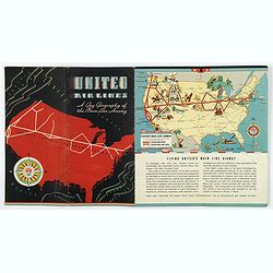
United Airways. A Gay Geography of the Main Line Airway.
A unique United Airlines Booklet, with original wrappers, with color illustrations on each page with pictographic / pictorial maps (16 pages including covers). It is high...
Place & Date: U.S.A., 1938
Selling price: $225
Sold in 2020
A Map of the City of Philadelphia, showing the Location of the Volunteer Fire Companies. . .
A fine, large pictorial plan of the City of Philadelphia, based on the drawing by Jacob Riegel in 1937, which itself was based on an earlier work dating back to 1794. The...
Place & Date: Philadelphia, 1938
Selling price: $200
Sold in 2021
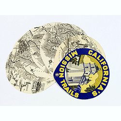
California's Mission Trails.
A most unusual 'disk' shaped series of circular maps taking in the Californian coastline from Los Angeles north to San Francisco America's most beautiful 400 miles.There ...
Place & Date: California, 1939
Selling price: $80
Sold in 2017

Newport / Mount Hope Bridge, RI.
One side shows a large, decorative and colorful map of part of Rhode Island, from Warren Point in the south, to Newport in the west, to Bristol in the north, to Cape Cod ...
Place & Date: Bristol, 1939
Selling price: $65
Sold in 2018

Historical Map of the Old Northwest Territory.
A large, folding lithographic map of the "Old Northwest Territory" in the time of Thomas Jefferson. This map seems to cover the states of Illinois, Indiana, Ohi...
Place & Date: Ohio, ca. 1940
Selling price: $255
Sold in 2016
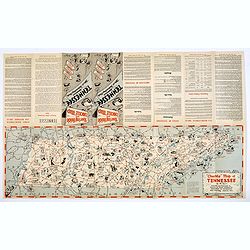
Chuckle Map of Tennessee.
A comic 'look' at the state of Tennessee, packed with highways, towns, points of interest, sports, produce, and lots of cartoon like characters depicting various activiti...
Place & Date: Nashville, ca. 1940
Selling price: $50
Sold in 2018
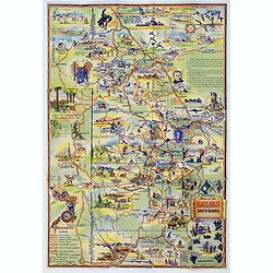
Map of the Black Hills of South Dakota.
A striking and 'busy' map of the Black Hills of South Dakota, "copied from maps compiled by South Dakota State Highway Commission". The entire map is filled wit...
Place & Date: South Dakota, ca. 1940
Selling price: $55
Sold in 2019
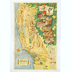
Sunkist Map of California.
A scarce educational map of the Sunkist Fruit Growers guide to operations in California, published during WWII. The map is beautifully presented with several illustrated ...
Place & Date: Los Angeles, 1940
Selling price: $1100
Sold in 2019

Gold Mine brand.
colorful Texas crate label from the Gold Mine brand and shipped by the Valley Fruit Company of Pharr, Texas. The company’s 111,000 sq. ft. packing facility was pivotal ...
Place & Date: Texas, ca. 1940
Selling price: $15
Sold in 2020
![A Pictorial Map of North America. [signed by Ernest Dudley Chase]](/uploads/cache/38841-250x250.jpg)
A Pictorial Map of North America. [signed by Ernest Dudley Chase]
Signed example of Ernest Dudley Chase's pictorial map of North America.According to Rumsey: Pictorial map of the North American continent, from Greenland in the north to ...
Place & Date: Winchester, 1945
Selling price: $325
Sold in 2017
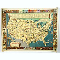
Folklore Music Map of the United States.
A terrific, and unusual, fully colored lithographic map of the Folklore Map of The United States, by Dorothea Dix, and published by the Hagstrom Company Inc of New York i...
Place & Date: New York, 1945
Selling price: $245
Sold in 2018
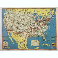
American Airlines Systems Map.
A striking, large poster, or pocket map of American Airlines flagship routes in relation to the air transport system of the United States. Routes flown also include parts...
Place & Date: New York, 1945
Selling price: $50
Sold in 2019
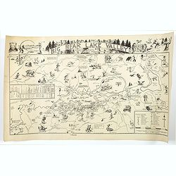
Big Bear Lake Valley.
An unusual 'cartoon' like map of Big Bear Lake Valley, and its Resorts, Sports, and Points of Interest. Big Bear Lake is situated in San Bernadino Co. in California.In ad...
Place & Date: Los Angeles, 1946
Selling price: $260
Sold in 2018
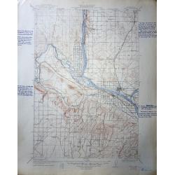
A set of 60 United States Department of the Interior Geological Survey Topographic Maps
The image shown is for Pasco Washington Quadrangle , most are Oregon, Washington and Idaho.The scale is 2 miles to the inch. Many have hand script descriptions in the mar...
Place & Date: 1906 – 1947
Selling price: $120
Sold in 2016
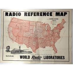
Radio Reference Map.
An interesting advertising map for 'WORLD RADIO LABORATORIES', “The World’s Largest Distributors of Amateur Radio transmitting Equipment”. It shows the monitoring s...
Place & Date: Council Bluffs, 1947
Selling price: $140
Sold in 2018
![[Post card] The United states as seen through the eyes of Texas.](/uploads/cache/40291-250x250.jpg)
[Post card] The United states as seen through the eyes of Texas.
Pictorial post card map of North America with the state of Texas taking up the entire middle portion of the map, and a large red heart in the middle reads "Biggest a...
Place & Date: Chicago, 1948
Selling price: $25
Sold in 2017

Nouvelle Angleterre - New York.
An interesting chromolithograph map of New York. Text and corresponding map with lavish vignettes of historic events, activities, crops, modes of transportation, structur...
Place & Date: Paris, 1948
Selling price: $27
Sold in 2018

Greater Portland, Maine.
Pictorial map of Portland, Maine, with decorative title cartouche and 6 views of landmarks at the margins. Design by Edwin Otis Nielsen Shows cities, landmarks, recreatio...
Place & Date: Portland, 1948
Selling price: $425
Sold in 2019
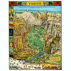
Yosemite
A colorful map of Yosemite Valley drawn by artist Jo Mora in 1931 and re-issued in color in 1941. The map shows many humorous scenes and shows the activities common at th...
Place & Date: Yosemite, Curry Company, 1941/1949
Selling price: $141
Sold in 2019
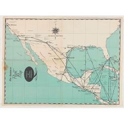
Pan American Flight Map - Mexico & Central America.
Pan American Airlines Flight Map of Mexico & Central America from the mid 1950's.
Place & Date: United States, ca 1950
Selling price: $60
Sold in 2020
Pan American Flight Map - Mexico & Central America.
Pan American Airlines Flight Map of Mexico & Central America from the mid 1950's.
Place & Date: United States, ca 1950
Selling price: $50
Sold in 2020
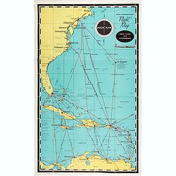
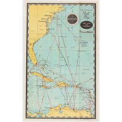
Pan American Airways New York - Caribbean.
Pan American Airlines Flight Map of New York to Caribbean from the mid 1950's.
Place & Date: United States, ca. 1950
Selling price: $50
Sold in 2021
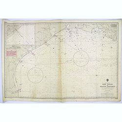
Gulf of Mexico. Ship Shoal to Brazos Santiago.
A large sea chart of the Gulf of Mexico, Ship Shoal to Brazos Santiago, 'from Admiralty Charts and US Government charts, corrected to 1943'. (In fact there are correction...
Place & Date: London, 1951
Selling price: $100
Sold in 2017

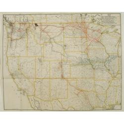
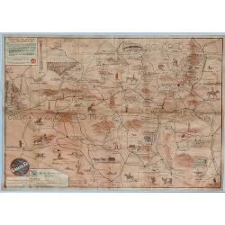
The Union Pacific West / Western Wonderlands.
A striking folded pictorial map of The western states of America, from Nebraska and Kansas to the Pacific coast. Inset of the region covered in context of general map of ...
Place & Date: United States, 1951
Selling price: $50
Sold in 2018
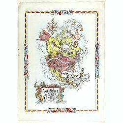
Amérique du Nord et Centrale.
color printed pictorial map of North and Central America, with decorative title cartouche and borders, depict countries, regions, major cities, industries, agriculture, I...
Place & Date: Paris, 1951
Selling price: $110
Sold in 2018
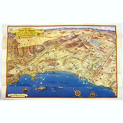
Ride the Roads to Romance along the Golden Coast...
A fun, large folding touring map of the Golden Coast and through the Sunshine Empire of southern California. From just north of Malibu Beach down past San Diego to Ensena...
Place & Date: California, 1952
Selling price: $160
Sold in 2016
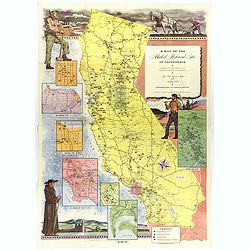
A Map of the Marked Historical Sites of California.
A large, colorful and impressive map of the American state of California, showing the historical sites of the state. There are 496 numbered sites depicted on the map.In a...
Place & Date: California, 1952
Selling price: $140
Sold in 2018

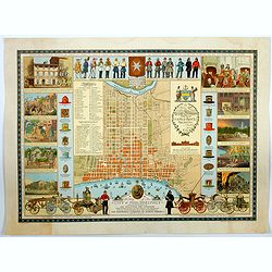
A Map of Downtown Chicago.
Silk map of Chicago’s Loop issued to celebrate the 100th anniversary of Marshall Field & Company.Though it nominally functions as a map of Chicago’s downtown, the...
Place & Date: United-states, 1952
Selling price: $200
Sold in 2021
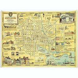
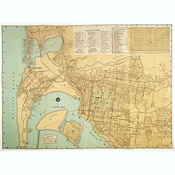
Historical Map of Old Baltimore.
A lovely, detailed map of the old 'downtown' area of Baltimore.
Place & Date: Baltimore, 1954
Selling price: $80
Sold in 2017
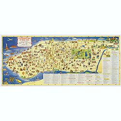
Colorgraph Map of New York.
A colorful, lively map of lower Manhattan, from Harlem south to the Battery. Numerous (380) small color illustrations throughout, depicting all that life in NYC has to of...
Place & Date: New York, 1954
Selling price: $70
Sold in 2017