Browse Listings in America > North America

Il Canada le Colonie Inglesi con Luigiana e Florida. . .
A splendid map of the east coast of America including the Great Lakes. With a decorative and fine title cartouche lower right hand corner, and mileage scales. From Zatta'...
Date: Venice, 1800
Selling price: ????
Please login to see price!
Sold in 2020

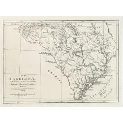
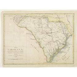
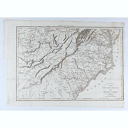
Carte de la partie méridionale des Etats-Unis.
Detailed 1801 map of North and South Carolina, Kentucky, Tennessee and Virginia. A separate publication of Pierre François Tardieu.With in lower left corner the address:...
Date: Paris, 1801
Selling price: ????
Please login to see price!
Sold in 2022

A Map Exhibiting all the New Discoveries in the Interior Parts of North America...
Published between 1795 and 1824, Aaron Arrowsmith's map of North America, is perhaps the single most important maps of North America after the American Revolution. It rep...
Date: London, 1802
Selling price: ????
Please login to see price!
Sold in 2020
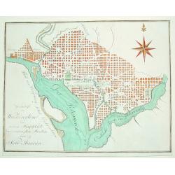
Grundrifs von Washington der nuen Hauptstadt ver vereinigten Staaten von Nord America
An extremely rare and desirable early plan of Washington DC. Of German origin, the map was published during Thomas Jefferson's first term as U.S. President. The work iden...
Date: Heidelberg, c. 1803
Selling price: ????
Please login to see price!
Sold

Amérique Septentrionale an XI 1803.
Curious map of North America taken from "Boussole des speculateurs". According to the title, an uncommon encyclopedical work should be useful for investors and ...
Date: Paris, 1803
Selling price: ????
Please login to see price!
Sold in 2012

Gli Stati Uniti dell'America.
A rare map of the United States of America, from "Nuova geografia universale antica e moderna cosmografica, fisica, topografica, di commercio e d'industria politica,...
Date: Rome, Vincenzo Poggioli, 1803
Selling price: ????
Please login to see price!
Sold in 2020

ETATS UNIS DE L' AMERIQUE.
A scarce early, original outline colored map of the United States, showing 17 organised states. Georgia still extends to the Mississippi River, shortly before the organis...
Date: Paris, 1803
Selling price: ????
Please login to see price!
Sold in 2019

Carte des Etats du centre, de L'Quest et du Sud des Etats-Unis.
Detailed map of the East Coast of America. Engraved by S.Glot.
Date: Paris, ca. 1804
Selling price: ????
Please login to see price!
Sold

Charte von dem Meer von Kamtschatka mit Capt. Jos. Billings und Mart. Sauers Reise Routen..
Uncommon map of the west coast of America showing the tracks of Billings and Sauers.Prepared by Ferd Götze.
Date: Weimar 1804
Selling price: ????
Please login to see price!
Sold
![[no title] Map of the United States and southern Canada.](/uploads/cache/44308-250x250.jpg)
[no title] Map of the United States and southern Canada.
This untitled map of the United States and southern Canada bears the imprimatur Smith & Jones Sculp. 13 Pleasant Row Pentonville (McCorkle #799.8). It is from an Engl...
Date: London, R.Philips, 1804
Selling price: ????
Please login to see price!
Sold in 2020
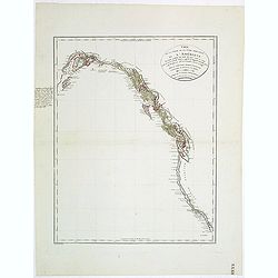
Carte de la Partie de la Cote Nord-Ouest de l'Amerique Reconnue pendant les Etes de 1792, 1793 et 1794 . .
A Cartographic Landmark -- George Vancouver's Map of the West Coast of North America. The first broadly accurate sea chart of the Pacific Coast of North America, by the g...
Date: Paris , 1804
Selling price: ????
Please login to see price!
Sold in 2021

Neue Charte von dem Mittleren Westlichen .. Nord Amerika..
A very nice map centered on north America, including part of Florida, north and south Carolina, Pennsylvania, etc. Title cartouche on the lower right corner.
Date: Weimar 1805
Selling price: ????
Please login to see price!
Sold

Neue Charte von den Mittleren, Westlichen und Südlichen Ländern der Nord-Americanischen Freistaaten..
A detailed and rare map covering good part of the central and eastern American States.
Date: Weimar 1805
Selling price: ????
Please login to see price!
Sold
Carte de l'Amérique Septentrionale Divisée en ses principaux Etats.
Map of North and Central America. From Atlas de la Géographie de toutes les parties du monde .. Ouvrage destiné pour l'education, et nécessaire aux négocians, aux voy...
Date: Paris, Prudhomme, Levrault, Debray, 1806
Selling price: ????
Please login to see price!
Sold in 2023

Canada, Louisiane, États-Unis.
Although dated 1794/95 [l'An 3e.], the map is a copy of an earlier map which appeared in Robert de Vaugondy''s 1778 atlas. Two maps on one sheet. The map of the western p...
Date: Paris, 1794 - 1806
Selling price: ????
Please login to see price!
Sold in 2016

Homme & Femme Ottawas.
Hand-colored mezzotints of Native Americans engraved by Félix Mixelle and Lachaussée Jeune after Jacques Grasset de Saint-Sauveur.
Date: Paris,1801-1806
Selling price: ????
Please login to see price!
Sold in 2011

Homme & Femme Iroquoia.
Hand-colored mezzotints of Native Americans engraved by Félix Mixelle and Lachaussée Jeune after Jacques Grasset de Saint-Sauveur.
Date: Paris,1801-1806
Selling price: ????
Please login to see price!
Sold in 2011

Homme et Femme de Virginie.
Hand-colored mezzotints of Native Americans engraved by Félix Mixelle and Lachaussée Jeune after Jacques Grasset de Saint-Sauveur.
Date: Paris,1801-1806
Selling price: ????
Please login to see price!
Sold in 2011

Homme & Femme de Népissens.
Hand-colored mezzotints of Native Americans engraved by Félix Mixelle and Lachaussée Jeune after Jacques Grasset de Saint-Sauveur.
Date: Paris,1801-1806
Selling price: ????
Please login to see price!
Sold in 2011
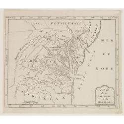
Carte de la Virginie et du Mariland.
Map centered on Chesapeake Bay and its hinterland, from Atlas de la Géographie de toutes les parties du monde.. Ouvrage destiné pour l'education, et nécessaire aux né...
Date: Paris, Prudhomme, Levrault, Debray, 1806
Selling price: ????
Please login to see price!
Sold in 2017

Carte des deux Florides et de la Louisiane inférieure : dressee pour les voyages de Mr. Robin dans les annees 1802, 1803, 1804, 1805 et 1806. . .
Very detailed map by J.B. Poirson, which shows all of Florida and Georgia, Louisiana north to Arkansas with the Ozarks clearly delineated, and east Texas with its rivers ...
Date: Paris, F. Buisson,1807
Selling price: ????
Please login to see price!
Sold in 2010
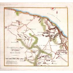
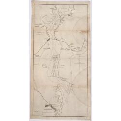
Investissment et Attaque D'York, dans la Virginie.
Engraved fold-out map from the French edition of John Marshall's "Life of George Washington". This historical map depicts Yorktown (the final engagement) and it...
Date: Paris, 1807
Selling price: ????
Please login to see price!
Sold in 2016

Partie Septentrionale du New-Jersey, et Positions des Armées Américaine et Britannique Après le Passage de la Rivière du Nord, en 1776
Striking and highly detailed Revolutionary War period rare copper engraved map illustrating the military operations of the American Revolution in northern New Jersey duri...
Date: Paris, 1807
Selling price: ????
Please login to see price!
Sold in 2014

Partie de l'etat de Rhode-Island, et position des armees Americaine et Britannique au Siege de Newport. . .29 Aout 1778.
A nice example of this Revolutionary War battle map showing the siege of Newport on August 29, 1778. It shows the harbour, islands, and opposing encampments. The map acco...
Date: Paris, 1807
Selling price: ????
Please login to see price!
Sold in 2019
Süd Carolina. Nach des Gouverneurs von Carolina J. Dalton Charte (1803) reducirt. . .
Interesting map of South Carolina and its cartographic source, based on Governor Drayton's map of South Carolina of 1803. The map provides lots of details with many place...
Date: Weimar, Geographisches Institute, 1808
Selling price: ????
Please login to see price!
Sold in 2018
Süd Carolina. Nach des Gouverneurs von Carolina..
Map of South Carolina. Copied after a map by J.Drayton.
Date: Weimar, 1808
Selling price: ????
Please login to see price!
Sold

Carte des Etats du centre, de L'Quest et du Sud des Etats-Unis.
Detailed map of the East Coast of America, taken from "Voyage à l'Ouest des Monts Alléghanys, dans les Etats de l'Ohio, du Kentucky et du Tennessée, et retour à ...
Date: Paris, Dentu, 1808
Selling price: ????
Please login to see price!
Sold in 2015

Amérique Septentrionale.
A charming map of North America. Very detailed. Published by Alexandre Emile Lapie, in his atlas Universel. Engraved by Tardieu.
Date: Paris 1809
Selling price: ????
Please login to see price!
Sold

Amerique Septentrionale. . .
Detailed map of the United States and Canada giving good detail along the east coast and the Lakes. Including Port St.Francois, Monterey, Pte. De Pins, Pt.Estero, Pte de ...
Date: Paris, 1809
Selling price: ????
Please login to see price!
Sold in 2011

AMERIQUE SEPTENTRIONALE.
A detailed map of North America, issued shortly before the publication of the official account of Lewis & Clark's expedition to the Pacific Ocean. The map shows a ver...
Date: Paris, 1809
Selling price: ????
Please login to see price!
Sold in 2019

Map of the Mississippi River from its source to the mouth of the Missouri..
Very rare map, one of the first maps of the Mississippi River with its tributaries, giving latitude and longitude markings along the way. Prepared during Zebulon Montgome...
Date: Baltimore 1811
Selling price: ????
Please login to see price!
Sold

Map of the interior of Louisiana with part of New Mexico..
Engraved by Haase. A mile stone map of the internal part of Louisiana, including the Mississippi in the East and the Mountains of Mexico in the West: with a part of New M...
Date: London 1811
Selling price: ????
Please login to see price!
Sold

Amérique septentrionale.
A fine map of North America published by the well-known Paris publisher of maps, globes and atlases C.F. Delamarche.
Date: Paris, 1811
Selling price: ????
Please login to see price!
Sold in 2017

Die Vereinigten Staaten von Nordamerika nach Arrowsmith und Lewis Karten vom Jahre 1795 und 1796. . .
A uncommon map of the United States, according to the title based on the maps by Arrowsmith and Lewis published in 1795 and 1796. Roads and Indian tribes are noted, in ad...
Date: Nuremberg, 1812
Selling price: ????
Please login to see price!
Sold in 2016

ETATS UNIS ET GRANDES ANTILLES.
An attractive map of the United States and West Indies with decorative cartouche, from 'Atlas Supplementaire du Precis de la Geographie Universalle de M. Malte-Brun by La...
Date: Paris, 1812
Selling price: ????
Please login to see price!
Sold in 2019
![[Official US Government Document.]](/uploads/cache/48156-250x250.jpg)
[Official US Government Document.]
An official US government printed document, completed in manuscript. An attractive copper engraved broadside, signed by President James Madison, appointing Daniel Chandle...
Date: Washington D.C., 1812
Selling price: ????
Please login to see price!
Sold in 2022

A Map exhibiting the frontiers of Canada and the United States, intended to illustrate the operations of the British & American armies
A scarce map issued during the War of 1812. Large inset lower right, "A sketch of the coast of North America; from the River St. Lawrence, to Chesapeake Bay." S...
Date: London, 1813
Selling price: ????
Please login to see price!
Sold in 2015

United States of America, Exhibiting the Seat of War on the Canadian Frontier from 1812 to 1815.
Edward Baines' 1816 map of the 'United States of America, Exhibiting the Seat of War on the Canadian Frontier from 1812 to 1815' A scarce of the US, published after the W...
Date: Leeds, 1816
Selling price: ????
Please login to see price!
Sold in 2021

Northern Provinces of the United States.
Somewhat later but very finely engraved and detailed map of the United States.
Date: Edinburgh, 1817
Selling price: ????
Please login to see price!
Sold in 2008

Nothern Provinces of the United States
Somewhat later but very finely engraved and detailed map of eastern part of the United States. Including the states and territories of New England, New York, Pennsylvania...
Date: Edinburgh, 1817
Selling price: ????
Please login to see price!
Sold in 2013

Southern Provinces of the United States
Somewhat later but very finely engraved and detailed map of the United States. Including the states and territories east of the Mississippi River to the Atlantic and as f...
Date: Edinburgh, 1817
Selling price: ????
Please login to see price!
Sold in 2013

Plan of the City of New York. New-York, Oct. 1817.
Plan de New-York engraved by W. Hooker for "Blunt's Strangers Guide", covering New-York covering Manhattan below 30th Street. Shows some existing and proposed s...
Date: New-York, Oct. 1817
Selling price: ????
Please login to see price!
Sold in 2014
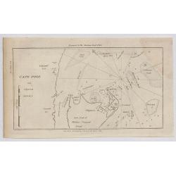
Cape Poge.
A small sea chart showing the eastern portion of Martha's Vineyard. Cape Poge Lighthouse can be seen at the northeast tip of Chapaquedick Island. This map was published ...
Date: New York, 1817
Selling price: ????
Please login to see price!
Sold in 2020

Little Egg Harbour.
A small sea chart showing Little Egg Harbour east of Tucker's Island.
Date: New York, 1817
Selling price: ????
Please login to see price!
Sold in 2020
Staten Island.
A small sea chart showing Staten Island, Long Island Bluff and Sandy Hook. This map was published in the “American Coast Pilot”, a detailed guide to harbours, capes a...
Date: New York, 1817
Selling price: ????
Please login to see price!
Sold in 2020

A View of West-Point on the River Hudson, With the Steam-Boat, invented by M. Fulton, going up from New-York to Albany.
A lithographic incunabula showing a view of West-Point on the River Hudson, with the Steam-Boat, invented by M. Fulton, going up from New-York to Albany. Lithograph after...
Date: Dijon, 1818
Selling price: ????
Please login to see price!
Sold in 2016

Proof state without title. (A View of West-Point on the River Hudson, With the Steam-Boat, invented by M. Fulton, going up from New-York to Albany.)
A lithographic incunabula showing a view of West-Point on the River Hudson, with the Steam-Boat, invented by M. Fulton, going up from New-York to Albany. Lithograph after...
Date: Dijon, 1818
Selling price: ????
Please login to see price!
Sold in 2016

Charte von der Nordwestkuste Americas Nach Vancouver.
An anonymous 1818 'Charte von der Nordwestkuste Americas nach Vancouver'. This map of the Pacific coast stretches from present-day San Francisco north to Anchorage, in Al...
Date: Prague, 1818
Selling price: ????
Please login to see price!
Sold in 2017
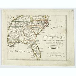
I Stati Uniti nell' America Settentrionale.
Only one sheet of four.The south eastern section of Bartolomeo Borghi's scarce 4 sheet map of the United States. From east of the Mississippi River. From: Kentucky and so...
Date: Firenze, 1818
Selling price: ????
Please login to see price!
Sold in 2019
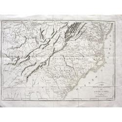
Carta delle provincie meridionali degli Stati - Uniti
Interesting map from the Italian translation of Francois La Rochefoucauld-Liancourt's famous travel guide for the United States. Showing the Carolinas, Georgia, Tennessee...
Date: Italy, 1819
Selling price: ????
Please login to see price!
Sold in 2008
Carta delle provincie meridionali degli Stati - Uniti.
An interesting map from the Italian translation of Francois La Rochefoucauld-Liancourt's famous travel guide for the United States.Showing the Carolinas, Georgia, Tenness...
Date: Italy, 1819
Selling price: ????
Please login to see price!
Sold in 2023
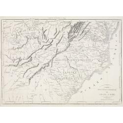
Carta delle provincie meridionali degli Stati-Uniti.
An Italian map of the south eastern United States from Botta's Storia della Guerra dell' Independenza degli Stati Uniti d'America, which was based upon Francois la Rochef...
Date: Milan, ca 1819
Selling price: ????
Please login to see price!
Sold in 2020

Partie septentrionale de l'Océan Pacifique ou l'on marqué les découvertes et les routes de M.rs de la Pérouse et Cook.
Detailed and rare map of the northern part of the Pacific with the Gulf of Alaska, British Columbia, south to St.Francisco and the east coast of Asia from Tartary to Kore...
Date: Paris, 1820
Selling price: ????
Please login to see price!
Sold in 2011
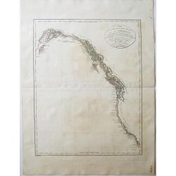
Carte de la partie de la cote nord-ouest de l'Amerique. Reconnue pendant les Etes de 1792, 1793 et 1794 depuis 29054' de latitude nord et 244033' de. . .
Detailed and rare map of the Gulf of Alaska, British Columbia, south to St.Francisco.Prepared by Edward Roberts after information by George Vancouver. Engraved by Tardieu...
Date: Paris, 1820
Selling price: ????
Please login to see price!
Sold in 2011

George Washington.
Rare lithographed portrait of George Washington, by an unknown artist; published by William Smith, 702 So. Third St, Philadelphia.Surrounded by scroll work.
Date: Philadelphia, c1820
Selling price: ????
Please login to see price!
Sold in 2016

Carte du Continent de l\' Amerique Nord.
A map of North America.
Date: Paris, 1821
Selling price: ????
Please login to see price!
Sold in 2013

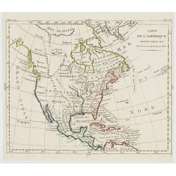
Carte Physique et Politique de l'Amérique Septentrionale. . .
Huge map of North America and the Caribbean showing the political divisions and colonial possessions with a color key at bottom. Brué prepared the maps for Louis de Onis...
Date: Paris, 1821
Selling price: ????
Please login to see price!
Sold in 2016

Spanish North America.
The excellent map by the Scottish engraver John Thomson, depicts Mexico from the Yucatan northwards to what would eventually become the Republic of Texas, and the Louisia...
Date: Edinburgh, 1821
Selling price: ????
Please login to see price!
Sold in 2016

Southern Provinces of the United States.
A very finely engraved and detailed map of United State, that Includes the states and territories east of the Mississippi River to the Atlantic and as far north as Lake E...
Date: Edinburgh, 1821
Selling price: ????
Please login to see price!
Sold in 2018

United States of America Compiled from the latest and best..
An uncommon and important map by the well recognized American cartographer John Melish, engraved by Samuel Harrison. Melish was the first American publisher to issue excl...
Date: Philadelphia, 1822
Selling price: ????
Please login to see price!
Sold

Map of the United States with contiguous British & Spanish Possessions.
.. compiled from the latest & best authorities by John Melish. Engraved by J. Vallance and [H.S.] Tanner. Entered according to Act of Congress the 16.th day of June 1...
Date: Philadelphia, 1822
Selling price: ????
Please login to see price!
Sold

Geographical, statistical, and historical map of the district of Columbia.
Includes a detailed plan of Washington DC, Georgetown and Alexandria and a number of roads and rivers in the District. Muds Tavern is shown just outside the District on t...
Date: Philadelphia, 1822
Selling price: ????
Please login to see price!
Sold in 2010

United States of America.
An uncommon and important map by the well recognized American cartographer John Melish. Shows both the newly formed state of Missouri and the massive Missouri Territory.M...
Date: Philadelphia, H.C. Carey & I. Lea, 1822
Selling price: ????
Please login to see price!
Sold in 2019

United States.
A small map of the east and south east of the United States. From Louisiana , up to the 'Northwest Territory' and across to New England and down to Florida. There is an i...
Date: London, 1822
Selling price: ????
Please login to see price!
Sold in 2019
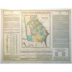
Geographical, Statistical and Historical Map of Georgia
Nice example of this fine map of Georgia, from the 1827 edition of Carey & Lea's Geographical, Statistical and Historical Atlas of America, with two columns of conte...
Date: Philadelphia, 1822
Selling price: ????
Please login to see price!
Sold in 2023
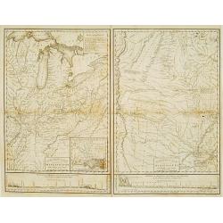
Country drained by the Mississippi Eastern Section. (with) Country of the Mississippi.
Rare map in two sheets stretching from Mississippi to Lake Superior. An inset box at top right includes a series of explanations to the symbols on the map. From: "Ac...
Date: Philadelphia, 1823
Selling price: ????
Please login to see price!
Sold
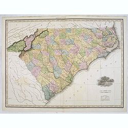
Map of North & South Carolina by H.S. Tanner.
Uncommon and important map of North and South Carolina by H.S. Tanner and published in his "New American Atlas" from 1823. Henry Schenck Tanner (1786-1858) was ...
Date: Philadelphia, Henry Tanner, 1823
Selling price: ????
Please login to see price!
Sold in 2014
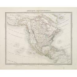
Amérique septentrionale.
A fine map of North America published by the well-known Paris publisher of maps, globes and atlases.The map includes "Mormonfort" next to Lac Salé. Mormons arr...
Date: Paris, 1824
Selling price: ????
Please login to see price!
Sold in 2023

Map of the Country Embracing the Route of the Expedition of 1823 commanded by Major SH Long.
Folding map originating from the rare book "Narrative of an Expedition to the Source of St. Peter's River : Lake Winnepeek, Lake of the Woods, &c., &c. Perfo...
Date: H.C.Carey and E. Lea, 1824
Selling price: ????
Please login to see price!
Sold in 2008

Freistaat von Nordamerica. . .
Scarce and unusual German map featuring primarily topography. Twenty-nine states and territories are outlined and named in a panel at bottom. A huge Louisiana stretches t...
Date: Berlin, 1824
Selling price: ????
Please login to see price!
Sold in 2016

OHIO (Geographisch - statistische und historische Charte de Staates Ohio)
From the rare German edition of Carey and Lea?s, A Complete Historical, Chronological, and Geographical American Atlas, an early and impressive map of Ohio bordered with ...
Date: London and Weimar, 1825
Selling price: ????
Please login to see price!
Sold
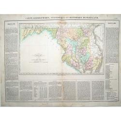
Carte Géographique .. du Maryland.
"Detailed map of Maryland. From J.A. Buchon, ""Atlas Gégraphique Statistique, historique et chronologique des deux Ameriques et des isles adjacentes; trad...
Date: Paris 1825
Selling price: ????
Please login to see price!
Sold

Massachusetts.
This is the map of Massachusetts is from a plano edition of the very scarce German edition of Carey & Lea's "A Complete Historical, Chronological, and Geographic...
Date: Weimar, 1822-1825
Selling price: ????
Please login to see price!
Sold

Carte Générale des Etats Unis de L''Amérique Septentrionale..
Detailed map of the United States. Prepared by L.Vivien and engraved in steel by Giraldon-Bovinet.Published by Menard and Desenne, rue Git-le-Ceur 8, Paris.
Date: Paris, 1825
Selling price: ????
Please login to see price!
Sold in 2015
![Carte Géographique [. . .] Connecticut.](/uploads/cache/14220-250x250.jpg)
Carte Géographique [. . .] Connecticut.
Detailed map of Connecticut. From J.A. Buchon, Atlas Gégraphique Statistique, historique et chronologique des deux Amériques et des isles adjacentes, traduit de l'atlas...
Date: Paris, 1825
Selling price: ????
Please login to see price!
Sold in 2015

Carte Geographique, Statistique et Historique Du New-Jersey.
Very detailed map from Buchon's french edition of Carey & Lea's American Atlas. The map is surrounded with lengthy text, dates, and tables. Includes information about...
Date: Paris, 1825
Selling price: ????
Please login to see price!
Sold in 2020
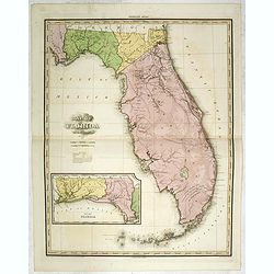
Map of Florida by H.S. Tanner. Improved to 1825
A very fine example of the revised 1825 issue of Henry Schenk Tanner's important map of Florida, with significant changes to the mapping. The second edition of the map sh...
Date: Philadelphia, Henry Tanner, 1825
Selling price: ????
Please login to see price!
Sold in 2014
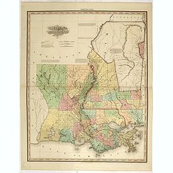
Louisiana and Mississippi by H.S. Tanner. Improved to 1825
A very fine example of the revised 1825 issue of Henry Schenk Tanner's important map of Louisiana and Mississippi. "Improved to 1825" has been added to the titl...
Date: Philadelphia, Henry Tanner, 1825
Selling price: ????
Please login to see price!
Sold in 2015
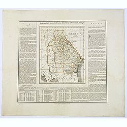
Geographisch-Statistische und Historische Charte von Georgia.
A nice map of the southern US state of Georgia, from the German version of Carey and Lea's English language atlas. This atlas was issued in six editions, from 1822-1827, ...
Date: Weimar, 1825
Selling price: ????
Please login to see price!
Sold in 2017

Carte Générale des Etats Unis de L'Amérique Septentrionale. . .
A highly interesting map of much of today's USA, the Bahamas, and parts of Canada. The map features the 54° 40' or Fight border with the huge Northwest region extending ...
Date: Paris, 1825
Selling price: ????
Please login to see price!
Sold in 2018
