Browse Listings in America > North America

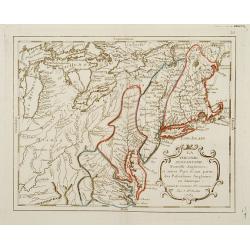
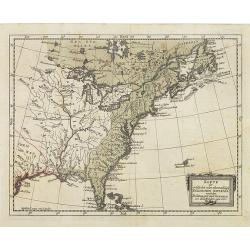
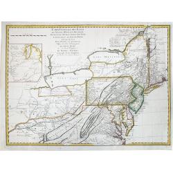
Cart de la Nouvelle Angleterre, Comprenant..
Complete title: ?Cart de la Nouvelle Angleterre, Comprenant les Etats de Massachusetts bay, N. Hamp Shire, Connecticut et Rhode Island?.An extremely scarce map of New Eng...
Place & Date: Paris 1782
Selling price: $580
Sold

L'Amerique Septentrionale divisé en fes principaux.
A finely engraved map of North America, prepared by Janvier. The map is most notable for it's depiction of Mer de L'Quest or Sea of the West, a great sea, easily the size...
Place & Date: Paris 1782
Selling price: $500
Sold

Amerique Septentrionale
Charming map of early North America including Central America and the West Indies. Filled with place names, Indian locations, and topographical information such as rivers...
Place & Date: Paris 1782
Selling price: $100
Sold in 2008

Carte d\'une partie de l\'Amerique.. et de la Louisiane..
A handsome and seldom-seen map of the Spanish colonial period. Included in Voyages de Mr. de Pagés.De Pages, a French nobleman and Navy captain, crossed the \"Provi...
Place & Date: Paris, 1782
Selling price: $700
Sold in 2008

Carte De La Louisiane Et Du Cours Du Mississipi Avec Les Colonies Anglaises. Revue, Corrigee et considerablemt. Augmentee en 1782 . . . Par Guillaume De L'Isle. . .
Unrecorded state of De L'Isle's seminal map, substantially updated with information on the British Colonies at the conclusion of the Revolutionary War.Accurate map showin...
Place & Date: Paris, 1782
Selling price: $1600
Sold in 2013

L'AMERIQUE SEPTENTRIONALE divisee en ses principaux Etats.
A fine example of Janvier's map of North America to illustrate the sea of the west "Mer ou Baye de l'Ouest", prior to the incorporation of information from Cook...
Place & Date: Paris, 1782
Selling price: $250
Sold in 2017
![L'AMERIQUE SEPTENTRIONALE divisee en ses principaux ETATS, 1782.[Great Western Sea]](/uploads/cache/82628-250x250.jpg)
L'AMERIQUE SEPTENTRIONALE divisee en ses principaux ETATS, 1782.[Great Western Sea]
A fine example of Janvier's map of North America to illustrate the sea of the west. "Mer ou Baye de l'Ouest", prior to the incorporation of information from Coo...
Place & Date: Paris, 1782
Selling price: $250
Sold in 2019
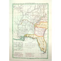
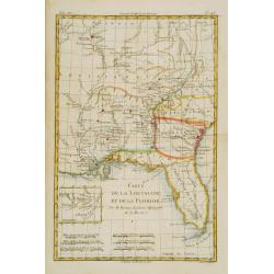
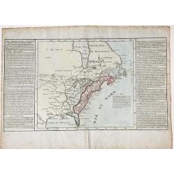
Carte de la Louisinae, et de Floride.
A handsome map of the American Southeast, including the Mississippi River Valley. The work covers from Charleston, South Carolina, extending west past New Orleans and nor...
Place & Date: ca.1783
Selling price: $200
Sold

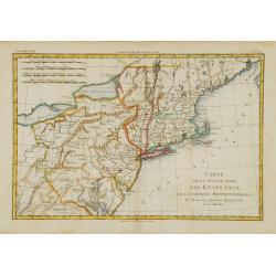
Amérique Septentrionale avec les Nouvelles Découvertes fait au Nord, par les Russes et les Anglois..
Rare map of North America, showing a remarkable NW Coast of America, including the recently discovered sea (by the Russians) of the West. The NW Coast and area near Canad...
Place & Date: Paris, 1783
Selling price: $800
Sold
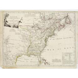
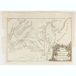
La Virginie, Pennsilvanie, Nouvelle Angleterre, et autres Pays fesant partie des Possessions Angloises, en Amérique..
Rare map, extending from Maine to the Chesapeake and west to include Lake Michigan. A boundary line confines the English colonies to the coast. F. Duquene is named along ...
Place & Date: Paris, 1783
Selling price: $330
Sold

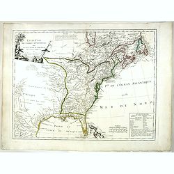
Partie Méridionale des possessions Angloises en Amérique..
Rare map of the South, showing the regions east of the Mississippi and extending North to Virginia and Kentucky. The map is filled with place names, Indian villlages, ear...
Place & Date: Paris, 1783
Selling price: $350
Sold
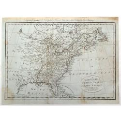
CARTE DES ETATS-UNIS D'AMÉRIQUE, et du Cours du Mississipi..
First state of three with changed date and imprint. It was first published in 1783 by Desnos, then by Esnauts et Rapilly and was re-issued in 1787. This map composed by B...
Place & Date: Paris 1783
Selling price: $3200
Sold

Partie de L'Amerique Septentrionale qui comprend le Canada, la Louisiana, le Labrador, le Groenland, les Etats-Unis et la Floride
Jean Lattré, Paris-based engraver and publisher. Worked with Robert de Vaugondy, J. Janvier and R. Bonne. " Atlas Monderne', 1771, 1783 , 1793. Rigobert Bonne (1727...
Place & Date: Paris, 1783
Selling price: $650
Sold

Canada IIe. Feuille.
Attractive map covering the eastern half of the United States, from the gulf of Mexico as far as Canada. Boundaries outlined in hand color.From theAtlas moderne ou collec...
Place & Date: Paris, ca 1783
Selling price: $150
Sold in 2013

L' Amerique Septentrionale divisée en ses principaux Etats... (Sea of the West)
Attractive map of North and Central America, ornated with a decorative title cartouche. Boundaries outlined in hand color.Showing the explorations of Verenrye with regard...
Place & Date: Paris, 1771-1783
Selling price: $300
Sold in 2017
![[No title] East coast of US.](/uploads/cache/23469-250x250.jpg)
[No title] East coast of US.
Covering the French Louisiana and the British Colonies with their western boundary on the Mississippi River.Nice detail, particularly of the French forts and Indian villa...
Place & Date: Paris ca 1783
Selling price: $150
Sold in 2014

CARTE DES ETATS-UNIS D'AMERIQUE, et du Cours du Mississipi. . .
Separate publication. First state of three. First published in 1783 by Desnos, then by Esnauts et Rapilly and was re-issued in 1787. Louis Brion de la Tour was a military...
Place & Date: Paris, 1783
Selling price: $3000
Sold in 2013

Carte Du Canada et de La Louisiane Qui Forment La Nouvelle France et Des Colonies Anglois . . . 1756
An important and rare pre-revolutionary French Indian war map by Nolin of Canada and the British Colonies, south to the Florida Peninsula, and from the eastern coastline ...
Place & Date: Paris, 1783
Selling price: $1400
Sold

Amérique septentrionale avec les nouvelles découvertes. . .
Large Mer de L'Quest. Rare map of North America, showing a remarkable NW Coast of America, including the recently discovered sea (by the Russians) of the West. The NW Coa...
Place & Date: Paris, 1783
Selling price: $300
Sold in 2019
Map of the United States in North America: with the British, French and Spanish Dominions adjoining, according to the Treaty of 1783.
One of the earliest obtainable English Maps to name the newly independent United States of America.The map shows the United States extending to the Mississippi River, wit...
Place & Date: London, 1783
Selling price: $600
Sold in 2017
![ETATS-UNIS DE L'AMÉRIQUE divises en 13 Provinces... [early USA].](/uploads/cache/83012-250x250.jpg)
ETATS-UNIS DE L'AMÉRIQUE divises en 13 Provinces... [early USA].
Attractive map from Lamarche's Atlas Elementaire. Printed 3 years after the foundation of the New Republic. Lamarche was the successor to Vaugondy (often known as Delamar...
Place & Date: Paris, 1783
Selling price: $130
Sold in 2019
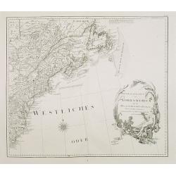
![AMERIQUE Septentrionale avec ses principales Divisions et leurs Capitales. [Mer de l'Ouest].](/uploads/cache/83552-250x250.jpg)
AMERIQUE Septentrionale avec ses principales Divisions et leurs Capitales. [Mer de l'Ouest].
An outlined colored map of north America , showing the Baye d'Hudson and the mythical 'Mer de l'Ouest'. With the names of cities, provinces and much more. With a numbered...
Place & Date: Paris, 1783
Selling price: $120
Sold in 2020

Parte del Nord del America Settentrionale ad uso della storia filosofica e politica degli Stabilimenti e del Commercio degli Europei nelle due Indie.
Uncommon map of the eastern part of North America. Drawn by R. Bonne for an Italian version of Abbé Raynal's Histoire philosophique et politique".
Place & Date: 1783
Selling price: $90
Sold in 2020

Amerique Septentrionale avec les Nouvelles Découvertes
The map of the North America in a quiet unusual shape.Comes from rarely seen Jean-Baptiste Nolin atlas “Atlas Général a l’usage des colleges et maisons d’educatio...
Place & Date: Paris, 1783
Selling price: $300
Sold in 2022

Karte des oestliehe oder ehemahlige ENGLISCHEN AMERIKA nach den Besitzungen und ..
Rare 18th century German map of eastern United States. From: Johan Jacob Moser, Nord-America nach den Friedenschlussen vom Jahr 1783,1784.A first state.
Place & Date: Germany 1784
Selling price: $475
Sold

Charte uber die XIII vereingte Staaten von Nord-America..
Fine large map of the newly formed United States of America. The southern states are shown with their western boundaries on the Mississippi River, although the coloring s...
Place & Date: Nuremberg ca. 1784
Selling price: $1675
Sold

Carte des nouvelles decouvertes au Nord de la Mer du Sud.
Although concentrating on the northern Pacific, this map show all of North America and Mexico.A very interesting Northwest Passage is shown.While the Russian coastline is...
Place & Date: Venice, 1776 - 1784
Selling price: $1200
Sold in 2008

Nouvelle Carte des Decouvertes Faites par des Vaisseaux Russes aux Cotes Inconnues del' Amerique Septentrionale avec les Pais Adiancents..
Santini's version of Gerhard Muller's landmark map of 1754 showing the discoveries of Captains Bering and Tschirikow.Muller originally published his map in response to Jo...
Place & Date: Venice, 1784
Selling price: $1050
Sold in 2011

Partie Méridionale de la Louisiane, avec la Floride, la Caroline et la Virginie..
Fine map of southeastern part of the United States after d'Anville's, to whom Santini gives credit in the cartouche.It covers the Atlantic coastline between the Chesapeak...
Place & Date: Venice, 1776 - 1784
Selling price: $1500
Sold in 2008

(BOSTON TEA PARTY) Die Einwohner von Boston werfen den englisch-ostindischen Thee ins Meer am 18 December 1773
SCARCE print, showing the citizens of Boston, disguised as Indians, boarding ships in Boston Harbor and throwing 342 chests of tea overboard. One of twelve scenes depict...
Place & Date: Germany, 1784
Selling price: $239
Sold in 2013
Karte des oestliehe oder ehemahlige ENGLISCHEN AMERIKA nach den Besitzungen und ..
Rare 18th century German map of eastern United States. From: Johan Jacob Moser, Nord-America nach den Friedenschlussen vom Jahr 1783.A first state.
Place & Date: Germany, 1784
Selling price: $350
Sold in 2022

Partie Occidentale du Canada et Septentrionale de la Louisiane..
Fine copper engraved map of the Great Lakes region after d'Anville's, to whom Santini gives credit in the cartouche.The map extends from the upper Mississippi River valle...
Place & Date: Venice, 1776 - 1784
Selling price: $465
Sold in 2013

Carte Générale du Canada, de la Louisiane, de la Floride, de la Caroline..
Map of the eastern part of the United States and Canada. With inset map of Hudson and Baffin bays. in the lower right corner.Venetian edition of d'Anville's map, from &qu...
Place & Date: Venice, 1776 - 1784
Selling price: $315
Sold in 2013

Partie Méridionale de la Louisiane, avec la Floride, la Caroline et la Virginie..
Fine map of southeastern part of the United States after d'Anville's, to whom Santini gives credit in the cartouche.It covers the Atlantic coastline between the Chesapeak...
Place & Date: Venice, 1776 - 1784
Selling price: $420
Sold in 2013
![Bowles's new pocket map of the following Independent States of North America : viz. Virginia, Maryland, Delaware, Pensylvania, New Jersey, NewYork, Connecticut & Rhode Island [. . .] by Lewis Evans.](/uploads/cache/34894-250x250.jpg)
Bowles's new pocket map of the following Independent States of North America : viz. Virginia, Maryland, Delaware, Pensylvania, New Jersey, NewYork, Connecticut & Rhode Island [. . .] by Lewis Evans.
Rare map, based on Evans' General Map of the Middle British Colonies In America (publ. as of 1755). The first map to eliminate "Middle British Colonies" and rep...
Place & Date: London, 1784
Selling price: $1800
Sold
A Correct Map of the United States of North America Including the British and Spanish Territories, Carefully Laid Down Agreeable to the Treaty of 1784
Fine early map of the United States with the Mississippi River as the Western Boundary. Created at the end of the American Resolution, after the Treaty of Paris. Publishe...
Place & Date: London, 1784
Selling price: $250
Sold in 2017

Nouvelle carte des decouvertes faites. . .
Santini's version of Gerhard Muller's landmark map of 1754 showing the discoveries of Captains Bering and Tschirikow.Muller originally published his map in response to Jo...
Place & Date: Venice, 1784
Selling price: $1000
Sold in 2015

A Correct Map of the United States of North America Including the British and Spanish territories, Carefully Laid Down Agreeable to the Treaty of 1784
One of the first maps published after the American Revolution, after the TREATY of PARIS. The west of the U.S. was Louisiana and New Mexico and west of the Mississippi ma...
Place & Date: London, 1784
Selling price: $211
Sold in 2015

Chart of the N.W. Coast of America and N.E. Coast of Asia explored in the Years 1778 & 1779. . .
A scarce edition of Captain James Cook's discoveries in the Pacific Northwest, Alaska, and the Behring Strait. The map shows the northeast parts of Asia and the northwest...
Place & Date: London, ca 1784
Selling price: $105
Sold in 2019

Charte über die XIII. vereinigte Staaten von Nord-America, Entworfen duch F.L. Güssefeld. . .
A large map of the 13 United States, shortly after the American Revolutionary War or the American War of Independence, which ended in 1783. A very detailed map with many ...
Place & Date: Nuremberg, 1784
Selling price: $650
Sold in 2019
ETATS-UNIS / DE L'AMÉRIQUE SEPTENTRIONALE / Avec / LES ISLES ROYALE, DE TERRE NEUVE, / DE S.T JEAN, L'ACADIE, &c. / 1785. / Supplement a l'Atlas de M. Robert de Vaugondy. / a Paris Ches Boudet Ingenieur du Roi.
Rare early map of the newly created United States with the variant imprint of Boudet. The map is highly detailed, extending to the Rio Grande and including notes on the S...
Place & Date: Paris 1785
Selling price: $1300
Sold

America settentrionale divisa ne'suoi principali stati.
Decorative and detailed map of North America, with some Contemp. manuscript notations in the Pacific.The map includes a notation of a Chinese Colony Fou Sang, based upon ...
Place & Date: Venise, 1785
Selling price: $400
Sold in 2012

Messico ouvero Nuova Spagna che contiene Il Nuova Messico La California con una Parte de Paesi Adjacenti. . .
Decorative and detailed map of the southern part of the United States, Mexico and Central America. The map is filled with remarkable detail throughout, particularly in Te...
Place & Date: Venise, 1785
Selling price: $300
Sold in 2019

Chart of the NW Coast of America and NE Coast of Asia...
Map of the Northwest Coast of Alaska. by Captain James Cook (1728-1779). On his third and final voyage (1776-1780), Captain James Cook made his most valuable discovery fo...
Place & Date: London, 1785
Selling price: $350
Sold in 2010

America settentrionale divisa ne\'suoi principali stati.
Decorative and detailed map of North America, with some Contemp. manuscript notations in the Pacific.The map includes a notation of a Chinese Colony Fou Sang, based upon ...
Place & Date: Venise, 1785
Selling price: $275
Sold in 2011

Messico ouvero Nuova Spagna che contiene Il Nuova Messico La California con una Parte de Paesi Adjacenti. . .
Decorative and detailed map of the southern part of the United States, Mexico and Central America. The map is filled with remarkable detail throughout, particularly in Te...
Place & Date: Venise, 1785
Selling price: $200
Sold in 2011

Messico ouvero Nuova Spagna che contiene Il Nuova Messico La California con una Parte de Paesi Adjacenti. . .
Decorative and detailed map of the southern part of the United States, Mexico and Central America. The map is filled with remarkable detail throughout, particularly in Te...
Place & Date: Venise, 1785
Selling price: $150
Sold in 2014

Carte de la Cote N.O. de L'Amerique et de la Cote N.E. de l' Asie.
Map of the north Pacific with Alaska, engraved by André. This is the general map of the Northwest Coast from the atlas volume of the first French edition of Cook's third...
Place & Date: Paris, 1785
Selling price: $32
Sold in 2021

ETATS-UNIS DE L'AMÉRIQUE SEPTENTRIONALE Avec LES ISLES ROYALE, DE TERRE NEUVE...
Scarce early map of the newly created United States, with a note which includes 10 new proposed states proposed by Thomas Jefferson--Silvania, Michigania, Chersonesus, Ar...
Place & Date: Paris, 1785
Selling price: $1000
Sold in 2016
ETATS-UNIS DE L'AMÉRIQUE SEPTENTRIONALE Avec LES ISLES ROYALE, DE TERRE NEUVE...
Scarce early map of the newly created United States, with a note which includes 10 new proposed states proposed by Thomas Jefferson--Silvania, Michigania, Chersonesus, Ar...
Place & Date: Paris, 1785
Selling price: $1000
Sold in 2020

A Map of the United States of America Agreeable to the Peace of 1783.
An unusual map of the United States issued shortly after the end of the American Revolutionary War. The map depicts the United States according to the 1783 Treaty of Pari...
Place & Date: London, 1785
Selling price: $60
Sold in 2018

(Russian map showing UNITED STATES, after Janvier).
An exceptionally rare, Russian map showing the eastern portion of the United States, after the popular map by Janvier. Text/imprint in Russian.
Place & Date: St. Petersburg, 1785
Selling price: $180
Sold in 2020

Carte de la Cote N.O. de l'Amerique et de la Cote N.E. de l'Asie, Reconnues en 1778 et 1779. Les parties de la Cote d'Asie qui ne sont pas ombrees sont tirees d'une Carte Manuscrite que nous donnerent les Russes.
Map of the North Pacific and contiguous coastlines of Alaska and Russia, published in the first French edition of the official account of James Cook's Third Voyage. The ...
Place & Date: Paris, 1785
Selling price: $275
Sold in 2022

A new map of North America, with the West India Islands..
An important and grand map of the United States, printed on four joined sheets and at a very large-scale, extends to include all of known North America and the West Indie...
Place & Date: London, 1763-1786
Selling price: $2500
Sold

L'Amerique septentrionale divisee en ses principaux etats.
A scarce map of North America showing the principal American States and the possessions of Spain and France. Not in Mcguirk, Mer de l'OuestOf cartographic interest is the...
Place & Date: Paris, 1786
Selling price: $250
Sold in 2021

AMERIQUE SEPTENTRIONALE dressée sur les Relations les plus modernes des Voyageurs et Navigateurs ou se remarquent LES ETATS UNIS. . .
This large map of North America and the West Indies was originally published in 1750: however after the Treaty of Paris recognized the United States in 1783 the map was '...
Place & Date: Paris, after 1786
Selling price: $750
Sold in 2011

Plan of Port des Francais on the North West Coast of America in 58° 37' Latitude North and 139° 50 of Longitude West Discovered in July, 1786. . .
A fine copperplate chart of the 'Port des Francais' in Alaska. After reaching the northwest coast of America, at the height of Mount Saint-Elie, after one year of navigat...
Place & Date: Paris, 1786
Selling price: $17
Sold in 2018
Carte Pour Servir Au Journal de Mr. Le Marquis de Chastellux Redigee par Mr. Dezoteux . . .
Chastellux's map of the Chesapeake region, including parts of Virginia, Maryland, Delaware & Pennsylvania. This map printed on thin paper shows Chastellux's route thr...
Place & Date: Paris, 1786
Selling price: $131
Sold in 2021

Amerique Septentrionale.
Fine map of Northern and Central America, showing even part of the South American continent, prepared by R.Bonne and included in his Atlas Encyclopédique.. Rigobert Bonn...
Place & Date: Paris 1787
Selling price: $100
Sold
Carte de la Louisiane, et de la Floride.
Handsome map of the American Southeast and the Mississippi River Valley. The map extends from Charleston, South Carolina west to include New Orleans and north well into I...
Place & Date: Paris 1787
Selling price: $130
Sold
Carte de la Partie nord des Etats Unies de L'Amerique Sept..
Fine map of the east coast of America, including the Lakes Erie and Ontario, prepared by R.Bonne and included in his Atlas Encyclopédique.. Rigobert Bonne (1727-1795) wa...
Place & Date: Paris 1787
Selling price: $100
Sold

Carte d'une partie de L'Amerique septentrionale..
The map was first published with a title Canada et Louisiane par le Sr. Le Rouge.. : during the Revolutionary War, Le Rouge reworked the plate and re-titled it Theatre de...
Place & Date: Paris 1787
Selling price: $925
Sold

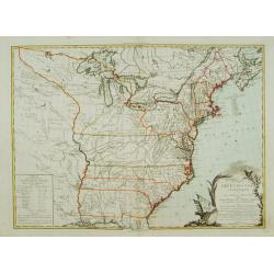
Carte Generale des Etats de Virginie, Maryland, Delaware, Pensilvanie, Nouveau-Jersey, New-York, Connecticut et Isle de Rhodes. Ainsi que des Lacs Erie, Ontario, et Champlain. D'Apres la Carte Ameriquaine de Louis Evans
Nice french map of the eastern part of the USA with the great lakes.
Place & Date: Paris, 1787
Selling price: $103
Sold in 2013

Carte de L'Entrée de Norton et du Détroit de Bhering, ...
The Bering Straits and Norton Sound, Alaska, showing the two attempts of Captain Cook's ship to penetrate the Straits on his third & final, fatal, voyage in 1778-79.
Place & Date: Paris, 1787
Selling price: $25
Sold in 2011

Carte de la Louisiane, et de la Floride.
Handsome map of the American Southeast and the Mississippi River Valley. The map extends from Charleston, South Carolina west to include New Orleans and north well into I...
Place & Date: Paris, 1787
Selling price: $180
Sold

A correct map of the United States of North America..
Fine and uncommon map of the United States according to the treaty of 1784. Engraved for BANKE'S New System of Geography, Published by the Kings Royal Licence.Thomas Bowe...
Place & Date: London, 1787
Selling price: $170
Sold in 2011

Carte de L'Entre de norton et du Detroit de Bhering.
Fine detailed map of the Behring Strait, the passage between Russia and Alaska. Includes the track of the voyage of Captain James Cook. Engraved and signed in engraving b...
Place & Date: Paris, 1787
Selling price: $30
Sold in 2015

Etats-Unis de l' Amerique Seple. avec le Canada et la Floride
An attractive, early map of eastern United States and Canada decorated with a Baroque style title cartouche.Interestingly, North and South Carolina, plus Georgia, extend ...
Place & Date: Paris, 1787
Selling price: $135
Sold in 2016
![[untitled map showing the route of the Continental Army from Boston to Yorktown]](/uploads/cache/40226-250x250.jpg)
[untitled map showing the route of the Continental Army from Boston to Yorktown]
Revolutionary War Battle map covering the East Coast of America from Boston Harbor to the Pamptico River in North Carolina. Its primary purpose is to depict the route of ...
Place & Date: Paris, c. 1787
Selling price: $750
Sold in 2018
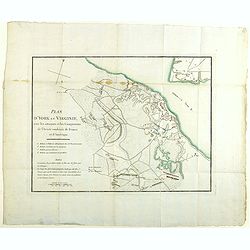
Plan d'York en Virginie, avec les attaques et les campemens de l'Armee combinee de France et d'Amerique
Map showing the battle of Yorktown, the final battle of the American Revolution, based upon French sources. The positions of the American, French and English forces and a...
Place & Date: Paris, Buisson, 1787
Selling price: $350
Sold in 2020
CARTE GENERALE DES ETATS de Virginie, Maryland, Delaware, Pensilvanie, Nouveau Jersey, New York, Connecticut et Isle de Rhodes. . .
A rare example of Louis Evans' important, first publication map of the Middle Colonies of 1755. Highlighted are Pensilvania and New Jersey. Engraved by Pierre Francois Ta...
Place & Date: Paris, Tardieu, 1787
Selling price: $600
Sold in 2020
![[2 sheets] Carte de la Cote N.O. de l'Amerique et de la cote N.E. de l' Asie. / Carte de L'Entree de Norton et du Detroit de Bhering. . .](/uploads/cache/83615-250x250.jpg)
[2 sheets] Carte de la Cote N.O. de l'Amerique et de la cote N.E. de l' Asie. / Carte de L'Entree de Norton et du Detroit de Bhering. . .
A set of maps of the north Pacific with Alaska, engraved by André. They are after the general map of the Northwest Coast from the atlas volume of the first French editio...
Place & Date: Paris, 1785-1787
Selling price: $55
Sold in 2020
![L' Ancien et le nouveau Mexique, avec la Floride et la basse Louisiane.. [Texas,California]](/uploads/cache/84796-250x250.jpg)
L' Ancien et le nouveau Mexique, avec la Floride et la basse Louisiane.. [Texas,California]
Fine map on 2 joined sheets, of the southern United States [Florida, Louisiana, Texas, New Mexico and California , further on Mexico, the Central American States, and the...
Place & Date: Paris 1787
Selling price: $130
Sold in 2021
DES POSSESSIONS FRANCOIS AUJOURD'HUI SOUS LA DOMINATION ANGLOIFES.
An interesting, decorative map from Labrador and the Hudson Bay area in Canada to the Gulf of Mexico. Inland as far as the Lake of the Woods and the Great Plains. French ...
Place & Date: Paris, 1787
Selling price: $110
Sold in 2022

Karte von den N.W.Amerikanische und N.O.E. Asia..
German edition of Cook's explorations along the NW Coast of America and NE Coast of Asia, based upon the original work by Lieutenant Henry Roberts.A detailed large-scale ...
Place & Date: Vienna 1788
Selling price: $270
Sold in 2008
Generalkarte von Nord America samt den Westindischen Inseln . . .
Map of the North American coastal states from New Scotland to Pennsylvania. Sheet 20 of Schraembl's "Allgemeiner Grosser Atlas", this is one of the first maps i...
Place & Date: Vienna, 1788
Selling price: $400
Sold in 2020
![[Map of North West America with Great Lakes region.]](/uploads/cache/26129-250x250.jpg)
[Map of North West America with Great Lakes region.]
Map of New Mexico, Louisiana, parts of Georgia, North Carolina and the Michigan lakes. Inset map of Baffin and Hudson Bay.Sheet 21 of Schraembl's "Allgemeiner Grosse...
Place & Date: Vienna, 1788
Selling price: $300
Sold in 2017

Pirogue du port des français. / Pirogue, trouvée au port des français.
From Atlas du Voyage de la Pérouse.Lituya Bay is a fjord located on the coast of the Southeast part of the U.S. state of Alaska. The bay was noted in 1786 by Jean-Franç...
Place & Date: Paris, 1788
Selling price: $77
Sold in 2010
![Untitled [Virginia Land Grant With Manuscript Map]](/uploads/cache/36846-250x250.jpg)
Untitled [Virginia Land Grant With Manuscript Map]
A fascinating item of colonial ephemera, this land grant printed on vellum with hand-written infill includes a manuscript map of the 2000 acres, set within a rectangular ...
Place & Date: Richmond, Virginia 1788
Selling price: $2200
Sold in 2016

LES ETATS UNIS DE L' AMERIQUE SEPTENTRIONALE. Partie Occidentale.
A detailed map of the region bounded by New England, Florida, Mississippi river, Louisiana and Great Lakes of Canada. Includes towns, mountains, rivers, lakes, Indians, F...
Place & Date: Paris, 1788
Selling price: $350
Sold in 2019