Browse Listings in Recent acquisitions
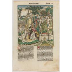
Adam and Eve, eating the apple and being expelled from paradise. Folio VII
One of the most sought-after prints from the Nuremberg Chronicle , Adam and Eve, eating the apple and being expelled from paradise.Page from the richest illustrated Incun...
Place & Date: Nuremberg, 12 July 1493
![Septima etas mudi. CCLXII [Armageddon.]](/uploads/cache/49053-250x250.jpg)
Septima etas mudi. CCLXII [Armageddon.]
One of the most sought-after prints from the Liber chronicarum or Nuremberg Chronicle, Armageddon, shows horrors in the sky engaged in enraged combat. Armageddon is the a...
Place & Date: Nuremberg, 12 July 1493
Selling price: $1000
Sold in 2025
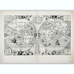
Benedict. Arias Montanus Sacrae Geographiae Tabulam Ex Antiq
THE EXTREMELY RARE FIRST STATE landmark world map, famed for its depiction of the Australian landmass.One of the earliest printed maps to depict the “terra incognita�...
Place & Date: Anvers 1571 /1572
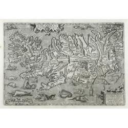
Islandia.
Perhaps the most famous map of Iceland. On the south side of the island a collection of all possible sea monsters is depicted. Polar bears on ice flows and volcanoes in t...
Place & Date: Antwerp, 1603
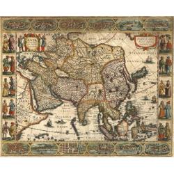
Asia recens summa cura delineata.
This is the rare early issue with decorative paneled borders of four sides. It is surrounded by elaborate borders incorporating twelve bird's eye views of cities and te...
Place & Date: Amsterdam, H.Hondius,1623
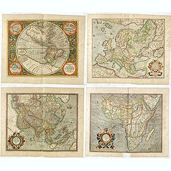
Set of four continents.
Fine set of 4 continents prepared by Gerard Mercator. The general map of Europe, as well as Americae Pars, Greenland, Iceland, a Polar landmass, along with the mythical i...
Place & Date: Amsterdam, 1628
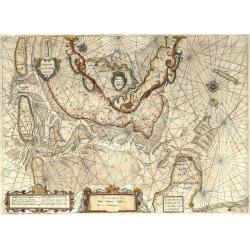
Pascaarte, van de Zuijderzee, Vliestroom, Vlie, en Amelandergat…
Very rare chart of the Dutch Zuiderzee, here in its rare 5th state (o f6). Showing the coastlines along the Dutch inner sea. Two compass roses indicate north to the left ...
Place & Date: Amsterdam, c. 1660
![[2 maps] Nieuwe Hemels Spiegel waer door den hemel, aerde en zee dadelik kan afgemeten werden. Noyt gesien en dat op alles Polus hooghten seer noodig voor Stierlieden.](/uploads/cache/49046-(1)-250x250.jpg)
[2 maps] Nieuwe Hemels Spiegel waer door den hemel, aerde en zee dadelik kan afgemeten werden. Noyt gesien en dat op alles Polus hooghten seer noodig voor Stierlieden.
A set of two copper engravings made by Andreas van Luchtenburg in Rotterdam, published separately by Cornelis Danckerts. Nieuwe Hemels Spiegel waer door den hemel, aerd...
Place & Date: Rotterdam, Amsterdam, ca. 1684
![(Chatelain "Atlas Historique" in 7 volumes.]](/uploads/cache/47053X-250x250.jpg)
(Chatelain "Atlas Historique" in 7 volumes.]
Henri Abraham Chatelain, whose Atlas Historique was one of the most expansive encyclopedias of the age. First published in 1705, Chatelain's Atlas Historique was part o...
Place & Date: Amsterdam: Chez Zacharie Châtelain, 1732 - 1739
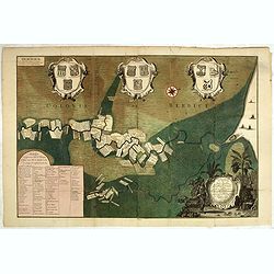
Naaukeurige Platte Grond van den Staat en den Loop van Rio de Berbice Met derzelver Plantagien in de Geoctrojeerde Colonie de Berbice Gelegen. . .
Uncommon large-scale map of Berbice with Rio de Berbice and Rio de Canjewith at the bottom left a list of plantation owners. In top 3 x 3 coats of arms in cartouches. The...
Place & Date: Amsterdam, 1742
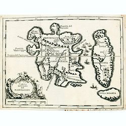
Carta Topografica dell' Isola Del Maritaggio di Monsieur le Boble per la prima volta. Tradotta dal francese in italiano.
Second Italian printing of Eustache Le Noble’s "Carte de l’isle de marriage." The book’s text offers instructions on how to reach this matrimonial island ...
Place & Date: Cosmopoli, 1766
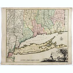
Connecticut and Parts adjacent at Amsterdam. .
A nice example of this early map of the state of Connecticut with part of Rhode Island to the east, Long Island to the south, and New York to the east. Rivers, roads, t...
Place & Date: Amsterdam, 1780

View of Singapore
Very rare view of Singapore from the Singapore River Basin. With a numbered key (1-19) underneath the illustration. In the center Government Hill with Governer's House (1...
Place & Date: ca. 1850
Volume III of the monumental atlas, ‘L’Orbe Cattolico ossia Atlante Geografico Storico Ecclesiastico’.
PETRI Girolamo's extremely rare Atlas volume III of the monumental atlas, ‘L’Orbe Cattolico ossia Atlante Geografico Storico Ecclesiastico’, respectively depictin...
Place & Date: Rome, 1858
![[Lot of 9 maps] Plan général de Sébastopol avec indication des travaux du siege et de la defense au 28 mars - 9 avril 1855. Feuille 10. xiii](/uploads/cache/33907-250x250.jpg)
[Lot of 9 maps] Plan général de Sébastopol avec indication des travaux du siege et de la defense au 28 mars - 9 avril 1855. Feuille 10. xiii
A group of nine (of 14) very rare panoramic town-plans of the siege of Sebastopol or maps of the Crimea. In lower margin : "Gravé au Dépôt topographique de la Gue...
Place & Date: St. Petersburg, N. Thieblin, 1863
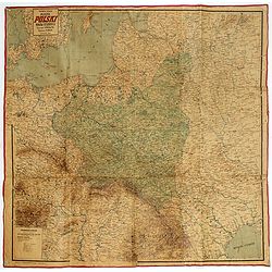
Mapa Polski i Krajów Osciennych - Wydanie trzecie. Opracowal Stanislaw Max. Wydani M. Arcta.
‘The Birth of Modern Poland on a map’ - an excellent wall map of Poland and surrounding regions, published in Warsaw near the end of World War I, when Poland’s fate...
Place & Date: Warsaw, [H. Sklodowski], 1918
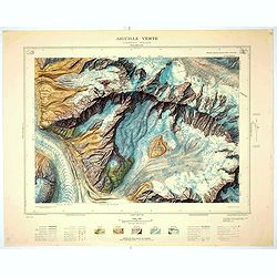
Aiguille verte - Chamonix N°6 Sud
Magnificent 1:10,000 scale color printed map of l'Aiguille verte (Chamonix N°6 Sud) based on stereotopographic ground and aerial surveys carried out in the field in 1950...
Place & Date: Paris, 1953
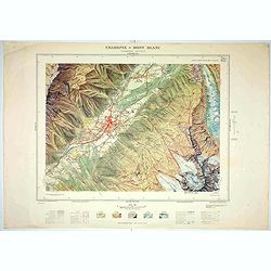
Chamonix - Mont Blanc - Chamonix N°5 Sud.
Magnificent 1:10,000 scale color printed map of Chamonix - Mont Blanc (Chamonix N°5 Sud) based on stereotopographic ground and aerial surveys carried out in the field in...
Place & Date: Paris, 1953
![[A collection of 100 Soviet propaganda poster published in the 1980's]](/uploads/cache/47076-250x250.jpg)
[A collection of 100 Soviet propaganda poster published in the 1980's]
A collection of 100 Soviet propaganda posters published during the early years of the Perestroika & Glasnost period. Most posters are made by Plakat (All-Union Poster...
Place & Date: Moscow, ca. 1980-1989