Browse Listings in America > South America
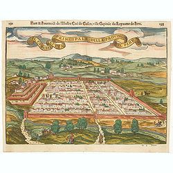
Il Cuscho citta principale della provincia del Peru.
A very desirable and scarce item of this decorative and early bid's-eye town-plan of the Inca city of Cuzco. Several figures shown inside the city walls and on the hillsi...
Place & Date: Lyons, 1564
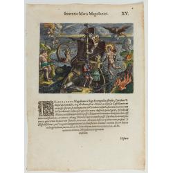
Inventio Maris Magallanici.
Allegorical scene allegorical image celebrating the circumnavigation of the earth by Ferdinand Magellan. The image shows Magellan on board of his ship, surrounded by myth...
Place & Date: Frankfurt, 1594
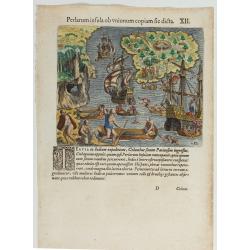
(Island of Pearls) Perlarum insula ob unionum copiam sic dicta.
A depiction of Cubagua as the Perlarum Insula (Island of Pearls), with in the foreground, two large ships send dinghies toward busy Native Americans collecting pearl oyst...
Place & Date: Frankfurt, 1594
![Hanc Tabulam continens Laetam Pharnambuci.. . [Brazil].](/uploads/cache/16521-250x250.jpg)
Hanc Tabulam continens Laetam Pharnambuci.. . [Brazil].
An extremely rare and decorative map of coast-line of Pernambuco. With one inset: In the upper left corner a map of Brazil, with title in five lines Dutch and five lines ...
Place & Date: Amsterdam, 1630
![[The Dutch covalesce on the Isle Santa Clara.]](/uploads/cache/40359-250x250.jpg)
[The Dutch covalesce on the Isle Santa Clara.]
Fanciful map of the Island of Santa Clara (Isla Do Francez), as seen by the Dutch in 1599, during the exploration of Olivier de Noort, published by Theodore de Bry, one y...
Place & Date: Frankfurt, M.Merian, 1633
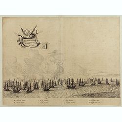
Quartum Praelium Coniovian inter et Fluvium Rio Grande XVII Ian
Decorative engraving of the fourth sea battle with the Portuguese fleet offshore at the Rio Grande, in1640. Engraved by J. van Brosterhuyzen after a design by Frans J. Po...
Place & Date: Joannes Blaeu, Amsterdam 1647
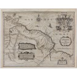
GUIANA sive Amazonum Regio.
This very rare map shows northwest Latin America with Surinam and French Guiana and was engraved by Johann Philipp Thelott. The map comes from the work of Johann Joachim ...
Place & Date: Franckfurt 1669
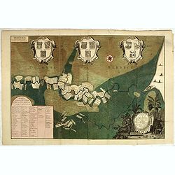
Naaukeurige Platte Grond van den Staat en den Loop van Rio de Berbice Met derzelver Plantagien in de Geoctrojeerde Colonie de Berbice Gelegen. . .
Uncommon large-scale map of Berbice with Rio de Berbice and Rio de Canjewith at the bottom left a list of plantation owners. In top 3 x 3 coats of arms in cartouches. The...
Place & Date: Amsterdam, 1742
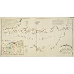
Nieuwe gemeten kaart van de colonie de Berbice met der zelver plantagiën en de namen der Bezitters. . .
Re-issue of his map from 1740, without the printed list of owners, with a large added contemp. hand-colored cartouche Relaas van de rebellie, ontstaan op de plantagien in...
Place & Date: Amsterdam, ca.1763
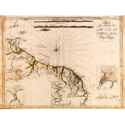
Guyana, Surinam, Amapa.
Very rare Ottoman printed map of Guyana, Suriname and Amapa. With Trinidad, an inset map of the mouth of the Rivers Essequibo, Courantyne, Suriname with Paramaribo.From C...
Place & Date: Uskudar (Istanbul), 1803
Selling price: $1750
Sold in 2024
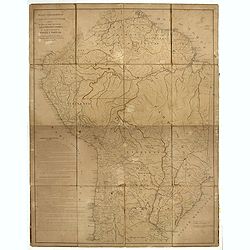
Mapa geogra´fico de la mayor parte de la Ame´rica Meridional que contiene los paises por donde debe trazarse la li´nia divisoria que divida los dominios de Espan~a y Portugal. . .
Rare first edition of the map drawn by Francisco Requena (1743-1824) after his expedition to the Amazon in order to delineate the boundary between the Spanish and Portugu...
Place & Date: Bourquin, F. Philadelphia, ca. 1876
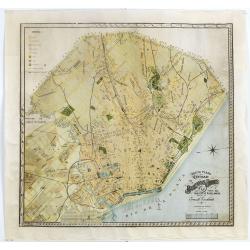
Nuevo plano de la ciudad de Buenos Aires y parte del partido de avellaneda . . .
A rare detailed city plan of Buenos Aires prepared in 1912 by Ernesto Escalante. The plan depicts the city from the Partido de Avellaneda and the Villa Riachuelo to the R...
Place & Date: Buenos Aires, 1912