.jpg)
Browse Listings in Europe > Netherlands > Limburg > maps

Ducatus Limburg.
In 1616 prepared by Aegidio Martini. Includes the towns of Maastricht as well as of Aachen. A very large title cartouche with two putti.
Place & Date: Amsterdam 1639

Tabula ducatus Limburch et comitatus Valckenburch. . .
The map describes the southern part of Limburg and reaches into Belgium (Liege, Verviers) and Germany. With two very decorative cartouches.
Place & Date: Amsterdam, 1690

Tabula ducatus Limburch et comitatus Valckenburch. . .
The map describes the southern part of Limburg and reaches into Belgium (Liége, Verviers) and Germany. With two very decorative cartouches.
- $250 / ≈ €220
Place & Date: Amsterdam, 1690

Le Limbourg ou font le duche de Limbourg. . .
Fine map of the Limburg with a decorative title and scale cartouche.Alexis-Hubert Jaillot (1632-1712), was a French cartographer. He joined the Sanson heirs and redrew Ni...
- $200 / ≈ €176
Place & Date: Amsterdam, 1692
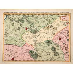
Carte particuliere des environs de Fauquemont et Aix la Chapelle.
An attractive map of the southern part of Limburg, centered on Valkenburg, Aachen, Rolduc and Dalem.
- $100 / ≈ €88
Place & Date: Paris, 1740

Département de la Meuse Inf.re.
Map representing the area around Maastricht, with a short key list in the lower right corner.From Atlas de la Géographie de toutes les parties du monde .. Ouvrage destin...
- $40 / ≈ €35
Place & Date: Paris, Prudhomme, Levrault, Debray, 1806