.jpg)
Browse Listings in Europe > Netherlands > Holland - North > maps
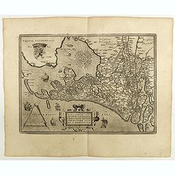
Hollandiae Antiquorum Catthorum..
This map shows Holland in great detail, including small towns, walled cities, rivers and lakes (many of which were reclaimed in the 17th century, and no longer exist). A ...
$500 / ≈ €440
Place & Date: Antwerp, 1598

Hollandia Septentrionalis.
An attractive miniature map of the north Holland, northwards from Amsterdam to the Zijpe polder, published by Petrus Bertius, in Amsterdam at the beginning of the sevente...
$150 / ≈ €132
Place & Date: Amsterdam, 1606

De Tesselstroom met de Gaten van Marsdiep./ De Mase met. . .
Three charts on one sheet depicting the entrances to the Zuiderzee between Holland, Texel and Vlieland. The entrances of the Maas with Rotterdam and in a small inset the ...
- $500 / ≈ €440
Place & Date: Amsterdam, 1662