.jpg)
Browse Listings in Europe > Netherlands
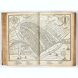
![[Lot of 25 leaves of France, Brabant, Netherlands, Luxemburg]](/uploads/cache/48264-250x250.jpg)
[Lot of 25 leaves of France, Brabant, Netherlands, Luxemburg]
Twenty-five text leaves with wood block illustrations relating to France, Brabant, the Netherlands, Luxemburg. From the 1552 Latin text edition of Münster's Cosmographia...
- $100 / ≈ €88
Place & Date: Basel, 1552
-250x250.JPG)
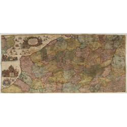
Fiandra Brabantia et Holanda nvova
Fiandra Brabantia et Holanda nvovaDella Fiandra Brabantia, et Olanda quinta nvova tavola d’EuropaThis map is the first known map of the Netherlands as a whole. It comes...
Place & Date: Venetië, 1561
![Groeninga MDLXXIII. [Groningen]](/uploads/cache/27192-250x250.jpg)
Groeninga MDLXXIII. [Groningen]
RECTO: A panoramic view of the city of Groningen dated 1573.VERSO: a woodcut of a cow, a bull and their calf.Taken from Sebastian Munster's encyclopedic work, the "C...
Place & Date: Basle, ca. 1564
-250x250.jpg)
La descrittione di Belgica con le sve frontiere (maps of the Seventeen Provinces)
La descrittione di Belgica con le sve frontiere Omnis Belgica intra Rhenum, marronam, Sequana[m] ac Oceanum, ... This is one of the earliest printed maps of the Sev...
Place & Date: Antwerp, 1567
DESCRIPTION DE TOUT LE PAIS BAS Autrement dict La Germanie Inferieure, ou Basse-Allemaigne…
First French edition. Illustrated with a coat of arms and portrait of Philips II, with a folding map of The Netherlands and maps and views of Brabant, Louvain, Brussel, A...
- $4500 / ≈ €3962
Place & Date: Anvers. Guillaume Silvius, 1567
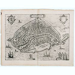
Dordrecht.
Very desirable and early town-plan of Dordrecht.From volume one of the greatest publication in this genre!. The Civitates was compiled and written by George Braun, Canon ...
- $200 / ≈ €176
Place & Date: Cologne, 1575
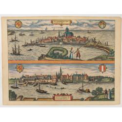
Roterodamum.. (Rotterdam) / Gouda.
One of the oldest panoramic views of the cities of Gouda and Rotterdam.From the greatest publication in this genre !. The ,Civitates, was compiled and written by George B...
- $500 / ≈ €440
Place & Date: Cologne 1580
Brabantiae Descriptio.
In an inset Mechelen and surroundings. Decorative scale and title cartouche with dedicational initials, which may refer to Laurentius Michaelis, who may be connected with...
Place & Date: Antwerp, 1598
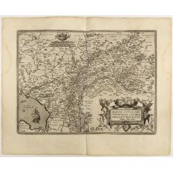
Gelriae, Cliviae, Finitimorumque Locorum Verissima..
East to the top. Fine map of Geldria and Limburg, prepared by Christian s'Grooten. Very fine title cartouche lower right with painter's utensils around the cartouche. ...
Place & Date: Antwerp, 1598
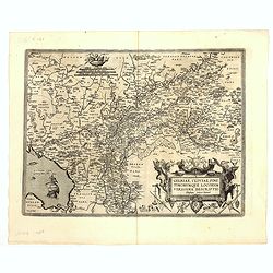
Gelriae, Cliviae, Finitimorumque Locorum Verissima..
East to the top. Fine map of Gelderland and Limburg, prepared by Christian s'Grooten. Very fine title cartouche lower right with painters utensils around cartouche.Dare t...
Place & Date: Antwerp, 1598
Hollandiae Antiquorum Catthorum..
This map shows Holland in great detail, including small towns, walled cities, rivers and lakes (many of which were reclaimed in the 17th century, and no longer exist). A ...
Place & Date: Antwerp, 1598

Inferior Germania.
Very rare map of the Benelux, centered on the Netherlands. According to van der Heijden only known in 6 examples. Two compass-roses with rumb lines but without the names ...
Place & Date: Amsterdam,ca. 1600

Descriptio Arcis Britannicae.
An original early 17th century copper engraved miniature antique map of the Roman remains in the sand dunes near Katwijk aan Zee in south Holland by Petrus Bertius. In Ro...
- $100 / ≈ €88
Place & Date: Amsterdam, 1606

Brabantia.
A lovely miniature map of the Duchy of Brabant, published by Petrus Bertius, in Amsterdam at the beginning of the seventeenth century. There is a nice, small strap-work t...
Place & Date: Amsterdam, 1606

Hollandia Septentrionalis.
An attractive miniature map of the north Holland, northwards from Amsterdam to the Zijpe polder, published by Petrus Bertius, in Amsterdam at the beginning of the sevente...
Place & Date: Amsterdam, 1606

Geldria.
An original early 17th century copper engraved miniature antique map of the Dutch province of Gelderland by Petrus Bertius, that was published in Amsterdam at the beginni...
- $100 / ≈ €88
Place & Date: Amsterdam, 1606
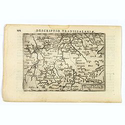
Descriptio Transisalaniae.
An original early 17th century copper engraved miniature antique map of the eastern Dutch region of Overijssel by Petrus Bertius. The title is displayed in a simple strap...
- $100 / ≈ €88
Place & Date: Amsterdam, 1606

Brabantia.
Decorative regional map of northern Belgium and the Dutch province Brabant, extending north to Breda and south to Namur, with Antwerp and Brussels near the center.Oriente...
- $150 / ≈ €132
Place & Date: Amsterdam, 1608

Auriaco infaelix Roermonda. . .
Showing the siege in May 1572 of Roermond.
- $100 / ≈ €88
Place & Date: Amsterdam, 1612

Gelriae, Cliviae, Finitimorumque Locorum Verissima Descriptio.
From the very rare Galle edition of the Ortelius Atlas, published after 1612. Fine map of Geldria and Limburg, prepared by Christian s'Grooten. Very fine title cartouche ...
Place & Date: Antwerp, after 1612
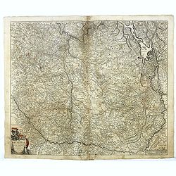
![Description de tovts les Pays-Bas, autrement appellez, la Germanie Inferieure, ov Basse Allemagne / par Messire Loys Gvicciardin [...]](/uploads/cache/48781-250x250.jpg)
Description de tovts les Pays-Bas, autrement appellez, la Germanie Inferieure, ov Basse Allemagne / par Messire Loys Gvicciardin [...]
Fine early edition of the French oblong edition of this famous description of the Low Countries. For the French edition most plates are newly engraved by Petrus Kaerius.....
- $3500 / ≈ €3082
Place & Date: Arnhem, Janssonius, J.,1613

Adrians VI. Pontifex Maximus Ultraiectinus Vixit Annos 64 1/2.
The engraving depicts a half length oval portrait of Pope Adrian VI, born Adriaan Florensz (Boeyens) (1459 ? 1523), was born in the Prince-Bishopric of Utrecht in the Net...
- $25 / ≈ €22
Place & Date: Amsterdam, Cloppenburch, 1621
![Lovenstein. [Loevestein]](/uploads/cache/13749-250x250.jpg)
Lovenstein. [Loevestein]
View of the castle Loevestein, near Gorinchem.. On the sky, three hands holding a quill, a stone and a stick are depicted. With a verse in two languages underneath the pi...
- $60 / ≈ €53
Place & Date: Frankfurt, 1624
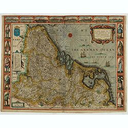
A new mape of Ye XVII Provinces of Low Germanie.
Showing all 17 Provinces of the Netherlands before the split between Spain and the Protestant Provinces under the House of Orange. The map was published while the war of ...
- $2300 / ≈ €2025
Place & Date: London, George Humble, 1626 [1627

Novissima et Accuratissima Brabantiae Ducatus Tabula.
North is to the right. Like all other maps of Brabantiae Ducatus, it encloses the area between the rivers Rhine, Maas and Schelde, with Namur as the most southern town. O...
- $350 / ≈ €308
Place & Date: Amsterdam, 1629

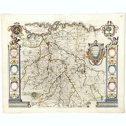
Ducatus Geldriae novissima. . .
Early map of Gelderland, but also including Utrecht, and parts of Brabant. Shows many cities (like Nijmegen, Eindhoven, Zutphen, Zwolle, etc), roads, rivers, woods, regio...
- $350 / ≈ €308
Place & Date: Amsterdam, 1629-1630

(Zeeland)
Rare map of Zeeland, first issued by Petrus Kaerius, than by Claes Jansz. Visscher. The copper plate was previously made by an anonymous engraver, and than came into the ...
- $1050 / ≈ €925
Place & Date: Amsterdam, 1631

Carte Generale des Dixet Sept Provinces des Pays Bas.
Rare map of the Low Countries, including Belgium, the Netherlands and Luxembourg after Tassin and offered for sale by the publisher N. Berey.
- $650 / ≈ €572
Place & Date: Paris, 1634

Comitatus Zutphania.
With an inset a plan of the town of Zutphen. Originally published by Petrus Kaerius in 1617. Published by Visscher in his "Belgium sive Germania Inferior continens p...
Place & Date: Amsterdam, 1634

Ducatus Limburg.
In 1616 prepared by Aegidio Martini. Includes the towns of Maastricht as well as of Aachen. A very large title cartouche with two putti.
Place & Date: Amsterdam 1639

Zuydhollandia stricte sumta.
The count ship of Holland was subdivided into a number of bailiwicks. The most southerly bailiwick, bordering on Brabant was named Zuid-Holland. Many floods changed the a...
- $350 / ≈ €308
Place & Date: Amsterdam, 1645

Zuydhollandia stricte sumta.
The count ship of Holland was subdivided into a number of bailiwicks. The most southerly bailiwick, bordering on Brabant was named Zuid-Holland. Many floods changed the a...
- $400 / ≈ €352
Place & Date: Amsterdam, 1645

Quarta pars Brabantiae cujus caput Sylvaducis.
The coat of arms of Brabant and 's-Hertogenbosch do appear on the map. But the municipal arms in the columns on right and left-hand side have not yet been filled in. The...
Place & Date: Amsterdam, 1645

Brabantia Ducatus.
A very decorative map by Willem Blaeu with west is at the top. On the lower left a magnificent cartouche with a sitting female figure carrying a globe and compasses and t...
Place & Date: Amsterdam, 1645
Quarta pars Brabantiae cujus caput Sylvaducis.
The coat of arms of Brabant and 's-Hertogenbosch do appear on the map. But the municipal arms in the columns on right and left-hand side have not yet been filled in. The ...
Place & Date: Amsterdam, 1645

Brabantia Ducatus.
West is at the top. On the lower left a magnificent cartouche with a sitting female figure carrying a globe and compasses and the coat of arms of Brabant. Like all other ...
- $500 / ≈ €440
Place & Date: Amsterdam, 1650

De Tesselstroom met de Gaten van Marsdiep./ De Mase met. . .
Three charts on one sheet depicting the entrances to the Zuiderzee between Holland, Texel and Vlieland. The entrances of the Maas with Rotterdam and in a small inset the ...
- $500 / ≈ €440
Place & Date: Amsterdam, 1662

Pas-Caart van de ZUYDER-ZEE, Texel ende Vlie-stroom.als mede 't Amelander gat (Hollandt/Vrieslandt)
An attractive chart of the Zuiderzee, now the inland water het IJselmeer.HOLLANDT / VRIESLANDTPas-Caart van de Zuyder-Zee, Texel ende Vlie-stroom.als mede 't Amelander g...
- $1200 / ≈ €1057
Place & Date: Amsterdam, c. 1665
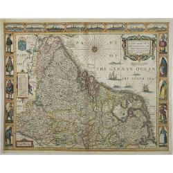
A new mape of Ye XVII Provinces of Low Germanie.
Showing all 17 Provinces of the Netherlands before the split between Spain and the Protestant Provinces under the House of Orange.The map was first published. At the same...
Place & Date: London, 1676

Belgium Foederatum emendate auctum et novissimé editum.
Fine detailed map of the area of the modern Netherlands less the southern part of Limburg. Title cartouche representing the commerce, the arts and the sciences. The Lion ...
Place & Date: Amsterdam, 1680
Tabula Ducatus Brabantiae continens Marchionatum Sacri Imperii et Dominium Mechliniense emendate à F. de Wit 1666
Shows present-day Belgium and Dutch province of Brabant. Including the Maas and Waal rivers. Shows Antwerp, Brussels, Namur, Liege and Venlo among other towns and cities....
Place & Date: Amsterdam, 1680
Selling price: $25
Sold in 2016

Paskaerte van het inkoomen van de MAES, Tot aen 't Eylandt Roosenburgh als mede 't Inkoomen van 't Goereesche Gat.. / Pascaert van 't Eylandt Roosenburg door de Oude en Nieuwe Maes....
A very attractive sea chart on two sheets of the mouth of the river Maas. The left sheet shows Dordrecht, Rotterdam and the fortress at Willemstad. Rghthand sheet dep...
Place & Date: Amsterdam, 1680

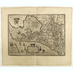
Transisalania provincia vulgo Over-Yssel auctore N.ten Have
Detailed map prepared by Nico ten Have.
Place & Date: Amsterdam, 1690

Tabula ducatus Limburch et comitatus Valckenburch. . .
The map describes the southern part of Limburg and reaches into Belgium (Liege, Verviers) and Germany. With two very decorative cartouches.
Place & Date: Amsterdam, 1690

Tabula ducatus Limburch et comitatus Valckenburch. . .
The map describes the southern part of Limburg and reaches into Belgium (Liége, Verviers) and Germany. With two very decorative cartouches.
- $250 / ≈ €220
Place & Date: Amsterdam, 1690

La seigneurie d'ouest-Frise ou Frise Occidentale
Fine map of the Friesland with a decorative title and scale cartouche.Alexis-Hubert Jaillot (1632-1712), was a French cartographer. He joined the Sanson heirs and redrew ...
Place & Date: Amsterdam, 1692

Le Limbourg ou font le duche de Limbourg. . .
Fine map of the Limburg with a decorative title and scale cartouche.Alexis-Hubert Jaillot (1632-1712), was a French cartographer. He joined the Sanson heirs and redrew Ni...
- $200 / ≈ €176
Place & Date: Amsterdam, 1692

s'Lants Zee-Magazyn en Scheeps Timmer-werf.
Decorative view of the back yard formerly the V.O.C. warehouse and arsenal for the Admiralty of Amsterdam, now-a-days the Scheepvaartmuseum (Maritime Museum).The print is...
- $250 / ≈ €220
Place & Date: Amsterdam, 1694

Prospectus Castelli Boxmerce / Prospectus Castelli Asten.
Early view of the castle of Boxmeer, engraved by H. Causé after a design by J. van Croes and published in "Vermakelykheden van Brabant en deszelfs onderhoorige land...
- $35 / ≈ €31
Place & Date: Amsterdam, 1696

Septendecm. Provinciae Germaniae Inferior. . .
A general map of the Netherlands, Luxembourg and Belgium. Fine title cartouche showing Mercury, Neptune, globe, etc. Lower right coat of arms of 17 Provinces.
- $150 / ≈ €132
Place & Date: Amsterdam, 1700
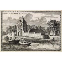
Generaliteits Kruyt-Magasyn.
The print depicts the gunpowder storage in Rotterdam. A most decorative item.
- $50 / ≈ €44
Place & Date: Amsterdam, 1703

La Mayerie de BOLDVC,. . .
From his atlas Oorlogs tablessen, Oft uytgesochte Kaarten . Covering the so-called area Meierij van 's-Hertogenbosch . Eindhoven in the centre of the map.
- $150 / ≈ €132
Place & Date: Amsterdam, 1706

Carte du Brabant, suivant les Nouvelles Observations de Messrs de L'Academie Royale des Sciences etc. . .
Although not renowned for the originality of his work, Pieter van der Aa is highly thought of for the design and quality of his output. Showing the present-day Dutch and ...
- $300 / ≈ €264
Place & Date: Amsterdam, 1713

L'Utrecht. . .
Although not renowned for the originality of his work, Pieter van der Aa is highly thought of for the design and quality of his output. Showing Dutch province of Utrecht....
Place & Date: Amsterdam, 1713
![Flessingue Ville de l'Ile de Walcheren. [Vlissingen]](/uploads/cache/13105-250x250.jpg)
Flessingue Ville de l'Ile de Walcheren. [Vlissingen]
A very RARE panoramic view of the city of Vlissingen. The plate is numbered in red pencil in the upper right corner.Engraved by Jean Crepy (the father), who was active as...
- $400 / ≈ €352
Place & Date: Paris, 1690-1720
Les Provinces des Pais Bas Autrichiens contenants en XXIV Feuilles les comtées d'Artois, de Flandres, de Hainaut, de Namur et des Duchées de Luxembourg…
Rare wall map of the Catholic of Austrian Low Countries, roughly the southern part of present-day The Netherlands, Belgium and Luxembourg. Map has some large cartouches, ...
Place & Date: Augsburg, 1725

Les Provinces Unies des Pays Bas, suivant les nouvelles observations. . .
With decorative title cartouche upper left corner.This example is unusual in having the additional separately engraved decorative framework border around the map, the res...
Place & Date: Amsterdam, 1728

Gemete Kaerte van de Stede Beverwyk, zoo als die tegenwoordigh zich vertoont.
Uncommon plan of Beverwijk made in the year 1739. Published in Hollandsche Arcadia. Title in Dutch and French.
- $75 / ≈ €66
Place & Date: Amsterdam, ca.1740

Platte Gront van de Hofstede Waterlant toebehorende den Ed. Achtb. Heer Dirk Trip Schepen te Amsterdam.
Uncommon plan of Hofstede Waterlant. Published in Hollandsche Arcadia. Title in Dutch and French "Plan de la Maison et Jardins appartenant a l'Illustre Dirk Trip Ech...
- $40 / ≈ €35
Place & Date: Amsterdam, 1740
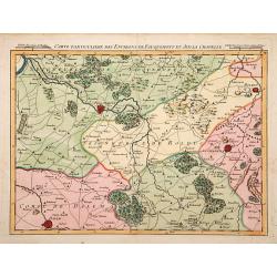
Carte particuliere des environs de Fauquemont et Aix la Chapelle.
An attractive map of the southern part of Limburg, centered on Valkenburg, Aachen, Rolduc and Dalem.
- $100 / ≈ €88
Place & Date: Paris, 1740

Comté d'Hollande, seigneurie d'Utrecht, comtés de Zelande, de Zutphen et duché de Brabant &c. Dressés sur les Mémoires faits par ordre des Estats Généraux et augmentés sur les Observations nouvelles.
Pocket atlas illustrated with a folded engraved title, a general map and 34 folded maps, including maps of the Netherlands, Belgium and parts of Germany.Provenance : Ex-l...
- $2400 / ≈ €2113
Place & Date: Paris, Crépy, ca. 1748

Transisalania vulgo Over-Yssel auct. N. ten Have. . .
Map of the central part of the Netherlands, prepared by N. ten Have with a decorative cartouche lower left.Joachim Ottens (1663 - 1719) and his sons Renier and Joshua wer...
- $225 / ≈ €198
Place & Date: Amsterdam, ca. 1750

Le Brabant. Ou la Campagne du Roy de 1746. . .
Uncommon map of Dutch and Belgium Brabant by George Louis Le Rouge, who was active from 1740- till 1780 as a publisher and was appointed engineer for the King of France.D...
- $300 / ≈ €264
Place & Date: Paris, ca. 1750

Belgium Foederatum auctius et emendatius edit..
Map of the northern part of the Netherlands. With a decorative title cartouche, with an inset map of South East Asia.
- $500 / ≈ €440
Place & Date: Augsburg, 1760

Partie Septentrionale des Pays Bas..
"Detailed map covering the Low Countries, published by Jean Latré."
- $400 / ≈ €352
Place & Date: Paris 1760
De Maria kerk te Leiden.
In the eighteenth and nineteenth centuries, there were many popular speciality establishments in Paris, Augsburg and London that produced optical viewing devices and spec...
- $200 / ≈ €176
Place & Date: Paris, 1760

The United Provincies.
Uncommon miniature map of The Netherlands, engraved by J.Ellis for "A New General and Universal Atlas Containing Forty five Maps by Andrew Dury".This miniature ...
- $50 / ≈ €44
Place & Date: London, 1761-1763

t'Oost-Indisch-Huys.
A decorative print of the East Indian House, the headquarters of the V.O.C., a place for meeting, trading and storage of spices and ship equipment. The maps and charts we...
- $150 / ≈ €132
Place & Date: Amsterdam, 1760-1767

s'Lands en Oost-Indische Lynbanen.
A decorative print of the Lynbanen a place were V.O.C. ship riggings and ropes were produced and kept.From J.Wagenaar: Amsterdam in zijne opkomst, aanwas, geschiedenisse....
- $100 / ≈ €88
Place & Date: Amsterdam, 1760-1767

Chorographie des Pays Bas Hollandois et Autrichiens. . .
Fine detailed and uncommon map of the modern Netherlands, Belgium and Luxembourg. Prepared by Etienne André Philippe de Pretot (1708-1787) after sources according to the...
- $200 / ≈ €176
Place & Date: Paris, 1772

Kapel van Vlierden.
Etching of the old chapel of Vlierden (near Deurne), from Het Verheerlijkt Nederland of Kabinet van hedendaagsche gezichten.. published by Isaac Tirion in Amsterdam. Etch...
- $80 / ≈ €70
Place & Date: Amsterdam 1745-1774
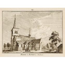
Kerk te Asten in Peelland.
"Etching of the church of Asten, from ""Het Verheerlijkt Nederland of Kabinet van hedendaagsche gezichten.."" published by Isaac Tirion in Amster...
- $80 / ≈ €70
Place & Date: Amsterdam 1745-1774

Les Dix-Sept Provinces des Pays-Bas. . .
Map of the present-day Benelux by L.C. Desnos. Engraved by Cordier.
- $100 / ≈ €88
Place & Date: Paris, 1784

Partie septentrionale des Pays-Bas comprenant .. des provinces unies. . .
Finely and crisply engraved map of Netherlands.Venetian edition of Giles Didier Robert De Vaugondy's map from Atlas Universel printed in 1776-84.Ornamental title cartouch...
Place & Date: Venice, 1776 - 1784
![Matelot Hollandais [Dutch sailor]](/uploads/cache/28927-250x250.jpg)
Matelot Hollandais [Dutch sailor]
Etching showing a typical Dutch sailor, after Jacques Grasset de Saint-Sauveur (1757–1810). Taken from "Costumes Civils actuels de tous les peuples connus, dessin�...
- $80 / ≈ €70
Place & Date: Paris, Pavard, 1788

Les Pays Bas François, Autrichiens, et Hollandois..
Finely engraved map centered on the Netherlands, extending to include Belgium and Luxembourg.Finely embellished with a large title cartouche surmounted by Mercury's head....
- $75 / ≈ €66
Place & Date: Paris, 1790

't dorp Aalst.
Rare print of the old church of Aalst (near Eindhoven), from Vaderlandsche gezichten of afbeeldingen.. by J.Bulthuis, printed by H.Gartman in Amsterdam.
- $100 / ≈ €88
Place & Date: Amsterdam 1786-1792

't dorp Boxtel.
Rare print of a view on the town of Boxtel (near Eindhoven), from Vaderlandsche gezichten of afbeeldingen.. by J.Bulthuis, printed by H.Gartman in Amsterdam.
- $150 / ≈ €132
Place & Date: Amsterdam, 1786-1792

Dutch landscape.
Finely executed water color in pen and ink and gray wash color. Showing a Dutch landscape with farm house and windmills on the horizon.
- $60 / ≈ €53
Place & Date: Probably The Netherlands, ca. 1800

Département de la Meuse Inf.re.
Map representing the area around Maastricht, with a short key list in the lower right corner.From Atlas de la Géographie de toutes les parties du monde .. Ouvrage destin...
- $40 / ≈ €35
Place & Date: Paris, Prudhomme, Levrault, Debray, 1806