Malta.
A miniature map of the lovely Mediterranean island of Malta, published by Petrus Bertius in Amsterdam, at the beginning of the seventeenth century. An attractive small ma...
- $200 / ≈ €176
Place & Date: Amsterdam, 1606

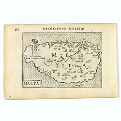
Descriptio Melitae / Malta.
A rare miniature map of Malta. Title cartouche on the lower left corner.First published in 1598 in his Caert-Thresoor, the plates were executed by the most famous engrave...
- $300 / ≈ €264
Place & Date: Amsterdam, Cornelis Claes, 1606

Malta maris medit.inf.
The representation of the town of Valletta on MaltaMeisner added in its center point a metaphorical representation of a medical doctor speaking out a baroque sentence of ...
- $400 / ≈ €352
Place & Date: Frankfurt, 1638

L'Isle de Malte avec ses Voisines./ La Valete Forte..
Uncommon map Malta. Four maps on one sheet. With inset maps of Valletta.Like Sanson, Briet was born in Abbeville and became a Jesuit at age 18. His "Parallela Geogra...
Place & Date: Paris, 1653
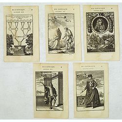
Set of 5 Malta related copper engravings.
Set of 5 Malta related copper engravings from the French edition the "Description De L'Univers" by Allain Manesson Mallet. French edition, 1683..By Allain Manne...
- $200 / ≈ €176
Place & Date: Paris, 1683
Malte.
A charming late 17th century French plan of La Valletta. With a ribbon style title cartouche and a nautical sailing ship scene across the top.By Allain Manneson Mallet (1...
- $225 / ≈ €198
Place & Date: Paris, 1683
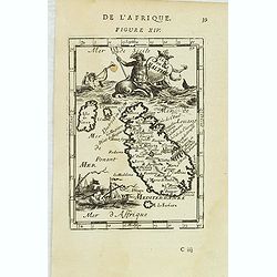
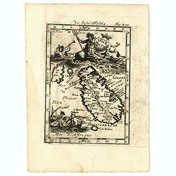
Isle de Malthe.
A charming late 17th century French map of Malta and Gozo with a large pictorial cartouche depicting Neptune and a mermaid, a nautical sailing ship scene across the botto...
- $250 / ≈ €220
Place & Date: Paris, 1683

D. Gregoire Caraffe G. M. de Malte. M.C.D.LXXXI.
Portrait of Gregorio Carafa (1615 - 1690), 62nd Prince and Grand Master of the Order of Saint John (Knights of Malta) 1680 until his death in 1690.The sea battle undernea...
- $30 / ≈ €26
Place & Date: Paris, Denys Thierry, 1683
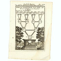
Arbre de Consanguinite Pour Faire Les Preuves de Noblesse de Chevalier de Malte.
An attractive piece that loosely translates to: Tree of Consanguinity To prove of Nobility of Knight of Malta. From Mallet's monumental Description de l' Univers, first p...
- $80 / ≈ €70
Place & Date: Paris, 1683
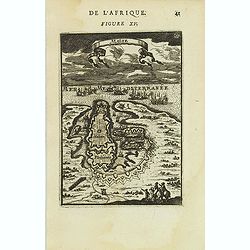
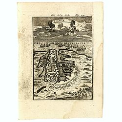
Isle de Malthe. Die Insul Maltha Fig: XIV.
A charming late 17th century map of Malta and Gozo with a large pictorial cartouche depicting Neptune and a merman, a nautical sailing ship scene across the bottom.The co...
- $250 / ≈ €220
Place & Date: Frankfurt, 1685
Malte Die Stadt Malta Fig: XV.
A charming late 17th century birds-eye view of Valletta and its fortifications from the southeast with battle ships in the sea. Title scroll in the sky.The copper plate s...
- $250 / ≈ €220
Place & Date: Franckfurt, 1685
![Ancien Cheva.er de Malte Ein Alter Malthese Ritter Fig: XVI [Together with] D. Gregoire Caraffe G.M. de Malte MDCLXXXI.](/uploads/cache/35860-250x250.jpg)
Ancien Cheva.er de Malte Ein Alter Malthese Ritter Fig: XVI [Together with] D. Gregoire Caraffe G.M. de Malte MDCLXXXI.
Two charming late 17th century engravings of an Knight of Malta and an round portrait of Gregoire Carafa.The copper plate seems during the printing process not well clean...
- $120 / ≈ €106
Place & Date: Frankfurt, 1685
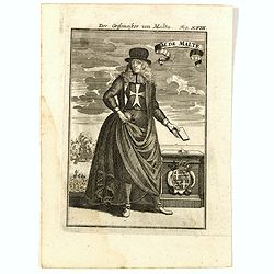
GM de Malte. Der Grossmeister von Malta Fig. XVIII.
Charming late 17th century engraving of grand master of Malta.By Allain Manneson Mallet (1630-1706), a well traveled military engineer and geographer who worked in 17th c...
- $120 / ≈ €106
Place & Date: Frankfurt, 1685
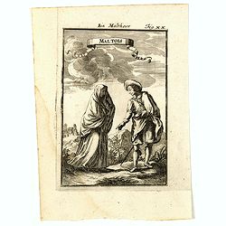
Maltois. Ein Maltheser Fig. XX.
Charming late 17th century engraving of a couple in local dress from Malta.By Allain Manneson Mallet (1630-1706), a well traveled military engineer and geographer who wor...
- $120 / ≈ €106
Place & Date: Frankfurt, 1685
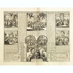
Carte du gouvernement ecclesiastique civil et militaire de l'Empire de l'ordre teutonique et de Malte et des villes anseatiques.
Interesting sheet with a detailed series of views showing the various councils of the Hanseatic League, including the councils of war, finance, state and the college of t...
- $75 / ≈ €66
Place & Date: Amsterdam, 1720
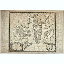
Plan général de la ville capitale de Malte dressé sur les memoires des grands officiers de l'Ordre, dédiée et présentée à S.A.S. Mgr le prince de Conty, prince du sang, grand prieur de France. . .
First edition of this attractive large scale plan of Valetta on Malta. To the left and right a numbered key 1 - 269. In lower left, a title cartouche with a dedication to...
Place & Date: Paris, 1751

Island of Elba / Malta / Inner harbour of Malta / Alexandria.
Four views on a sheet, engraved by S.I Neele. Profile views of the island of Elba, Alexandria and two profile views of Malta and the Inner Harbour in Valletta.
- $140 / ≈ €123
Place & Date: London, 1803

Gruppo delle Isole di Malta.
Uncommon map of Malta and Gozzo, published in "Atlante Geografico dell Italia".
- $250 / ≈ €220
Place & Date: Rome, 1860