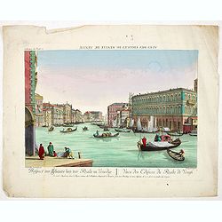
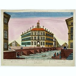
Prospect der Gebäude beij der Realte in Venedig. - Vuës des Edifices du Realte de Venisi. (Buildings near Rialto Bridge in Venice)
Rare so-called optical print illustrating buildings close to the Ponte di Rialto (Rialto Bridge) in Venice. Engraved by Fredrich Leizelt after Joseph Baudin, who was an i...
- $300 / ≈ €264
Place & Date: Augsburg, 1760

Carte réduite du Golphe de Genes. Conenant partie des cotes de Provence, celles de Piemont, de Genes et de Toscane . . .
Superb sea chart covering the coasts of the French and Italian Riviera's, Tuscany and northern tip of Corsica, prepared by Jacques Nicolas Bellin (1703-1772) the Royal Hy...
Place & Date: Paris, 1768

Etat de l'Eglise et Duché de Toscane.
Map of central Italy with Tuscany region by Rigobert Bonne.
- $75 / ≈ €66
Place & Date: Paris, 1771
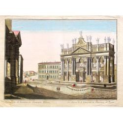
Tempum S.Joannis in Laterano Romae. . .
A so-called optical print. In the eighteenth and nineteenth centuries there were many popular specialty establishments in Paris, Augsburg and London which produced optica...
- $150 / ≈ €132
Place & Date: Italy, ca.1780
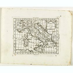
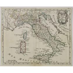
Italia divisa né suoi differenti stati.
Rare map of Italy, Sardinia and Corsica from "Atlante Novissimo ad uso Dei Giovani Studiosi Contenuto In Carte XXVII.", published by Giovanni Zempel in Rome, ca...
- $50 / ≈ €44
Place & Date: Rome, 1780
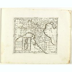
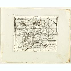
L'Italia Settentrionale presa da quella del Sig. Zannoni.
Rare map of Italy with inset map with Corsica and Sardinia, from "Atlante Novissimo ad uso Dei Giovani Studiosi Contenuto In Carte XXVII.", published by Giovann...
- $75 / ≈ €66
Place & Date: Rome, 1780
Parte Occidentale del Regno Italico, Il Piemonte e Genovestato.
Rare map of Piemonte region in Italy, centered on Piemonte region, Genova and Milan, from "Atlante Novissimo ad uso Dei Giovani Studiosi Contenuto In Carte XXVII.&qu...
- $75 / ≈ €66
Place & Date: Rome, 1780

Partie Meridionale du Cercle d'Autriche qui comprend La basse partie du Duché de Strie, Le Duché de Carinthie, divisé en haute et basse, Le Duché de Carniole. . . Et l'Istrie Impériale. . .
Uncommon, finely and crisply engraved map with large decorative title cartouche.Very detailed sheet that is centered roughly on Trieste and extends in to the mouth of the...
Place & Date: Venice, 1784

Partie Meridionale du Cercle d'Autriche qui comprend La basse partie du Duché de Strie, Le Duché de Carinthie, divisé en haute et basse, Le Duché de Carniole. . . Et l'Istrie Impériale. . .
Uncommon, finely and crisply engraved map with large decorative title cartouche.Very detailed sheet that is centered roughly on Trieste and extends in to the mouth of the...
- $100 / ≈ €88
Place & Date: Venice, 1784

L'Etat de Venise et le Duché de Mantoue..
Attractive map covering the region centered on today region Veneto and its chief town Venice.Extending westwards to include part of Lombardy and eastward to Trieste and I...
- $100 / ≈ €88
Place & Date: Paris, 1790

Partie de l' Italie, comprenant les Etats du Roy de Sardaigne. . .
Decorative map of northwest Italy and the Golfo di Genova. With ornamental title cartouche.Flanked by two columns of French text containing geographical information about...
- $100 / ≈ €88
Place & Date: Paris, 1790
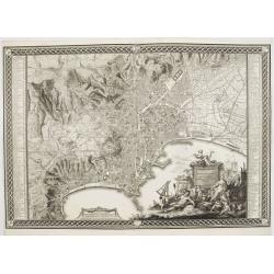
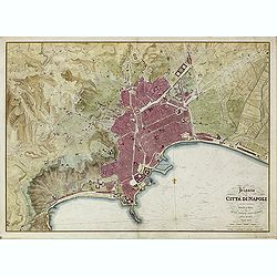
Planta della citta di Napoli come esifte nel prefeute Anno MDCCXC.
Stunning plan of Naples, prepared by Rizzi-Zannoni and engraved by Giuseppe Guerra from Naples. To the right and left a key to the important places of interest, among the...
- $1600 / ≈ €1409
Place & Date: Naples, 1790
Prospect von Livorn. - Venduta del Palazo del Console D'Olanda in Venezia Nova in Livorne.
So called optical print published by Joseph Carmine showing the home of the Dutch consul in Livorno. Engraved after a design of Antonio Piemontesi. A well-known publisher...
- $100 / ≈ €88
Place & Date: Augsburg, ca. 1790

L'alta Lombardia, Terzo Foglio Che comprende parte degli Stati del Re di Sardegna e parte della Repubblica di Genova.
Interesting map covering the border between France and Italy. In Nuovo Atlante Geografico Universale.
- $200 / ≈ €176
Place & Date: Rome, 1791

Bataille sur la rive droite de la Brenta. gagnée par les Français de 22 fructidor an 4. Bonaparte Général en chef. . .
Uncommon optical print showing the siege of Bassano in 1795, during the French Revolutionary Wars, in the territory of the Republic of Venice, between a French army under...
- $150 / ≈ €132
Place & Date: Paris, ca. 1795

Bataille sur la rive droite de la Brenta. gagnée par les Francais de 22 fructidor an 4. Bonaparte Général en chef. . .
Uncommon print showing the siege of Bassano in 1795, during the French Revolutionary Wars, in the territory of the Republic of Venice, between a French army under Napoleo...
- $150 / ≈ €132
Place & Date: Paris, ca. 1795

(Untitled map of northern Italy)
Including the towns of Milan, Bergamo, Mantova, Verona with the river Po in the bottom. One page from his multi sheet map "Carta del Territorio della Repubblica Casa...
- $250 / ≈ €220
Place & Date: Florence, 1797

Campagna di Roma Di nuova Projezione. . .
A very striking map of the area south east of Rome, engraved by G.Pitteri embellished with an colored pictorial title cartouche.
Place & Date: Venice, 1798
Selling price: $200
Sold in 2015
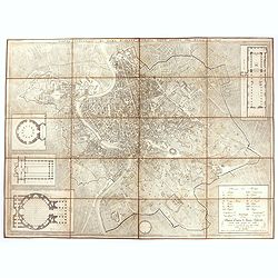
Plan de la ville de Rome, d'après celui publié par J.B. Nolli . . .
Beautiful town-plan of Rome, drawn up after the famous plan of Rome, executed by Giambattista Nolli in 1748. Decorated with a beautiful title cartouche topped by the coat...
- $1000 / ≈ €880
Place & Date: Paris, Jean, 1801

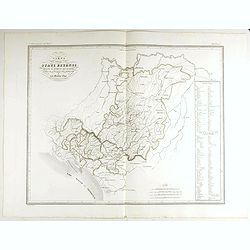
Carte générale des marches, positions, combats et batailles de l'Armée de réserve. . . (N°12)
Very detailed map centered on the Italian Alps showing the marches, positions, combats and battles of the famous Napoleon's crossing the Alps in the year 8 (1799) . In an...
- $750 / ≈ €660
Place & Date: Paris, 1803
Carte d' Italie . . .
Map of Italy from Atlas moderne portatif composé de vingt-huit cartes sur toutes les parties du globe terrestre .. A l'usage des Colléges, des Pensions & des Maison...
Place & Date: Paris, Prudhomme, Levrault, Debray, 1806
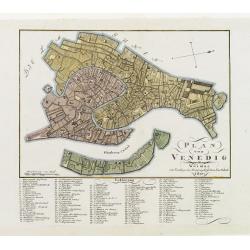
Plan von Venedig.
An uncommon and finely rendered town-plan of Venice. The work is highly detailed and provides a 133-point legend identifying the town's key sites and places of import. L...
Place & Date: Weimar, 1807

Département des Apennins Divisé en 3 Arrondissemens et en 18 cantons.
Published in the "Atlas National de France" at Chanlaire. Engraved by P.A.F. Tardieu. Represents the department of Apennines which was under French administrati...
Place & Date: Paris, 1790-1811
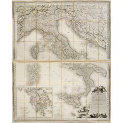
Carte Statistique, Politique, et Mineralogique de l'Italie o'u sont tracées toutes les routes, relais, et distances de postes. . .(2 Maps)
Folding map, extending west to east from Monaco to Otranto and north to south from The Alps to Malta, inset of Greece,. Cartouche depicting Rome and her classical past. P...
- $1000 / ≈ €880
Place & Date: Paris, 1816

Europe. Naples et Sicile. N.26.
Detailed map including lower half of Italy with the island of Sicily.From his famous Atlas Universel . This atlas was one of the most remarkable world atlases ever produc...
Place & Date: Brussels, 1825-1827
Pianta della Citta di Napoli e de' soui contorni.
Uncommon large scale town-plan of Naples. Drawn and engraved by the "Reale officio topografico".
- $1500 / ≈ €1321
Place & Date: Naples, 1828
Pianta topografica di Roma moderna estratta dalla grande del Nolli an 1829
Town plan of Rome based on map by Giovanni Battista Nolli, ( fl. 1692-1756). Engraved by Pietro Ruga. With a key (I - XIV), scale and text "Nuova pianta di Roma mode...
- $500 / ≈ €440
Place & Date: Rome, 1829

Guide de Florence et de ses environs Redige´ sur un plan entierement nouveau par l'Abbé A. Bulgarini et Traduit en français par A. Le Rendu. Deuxième édition.
Second edition. With 1 engr. folding plan (Pianta della Citta di Firenze. I. Balatri inc. e scris.) and 12 copper plates with views in Florence. The folding plan has meas...
- $550 / ≈ €484
Place & Date: Florence, Gaspard Ricci, 1839
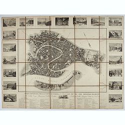
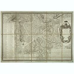
Pianta Topografica della R.a Città di Venezia con XIX de suoi principali prospetti.
A detailed town plan of Venice with an extensive key underneath and nineteen views of the important buildings among which: Piazza di S. Marco, Canal Grande, Tempio della ...
Place & Date: Milan: Santo Vallardi, c.1840

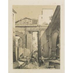
La Rue des Tombeaux à Pompeia.
Uncommon and decorative lithography published by Carl Johan Billmark and printed by Lemercier in Paris, 55 rue de Seine, the leading firm in Europe at that time. From: ...
- $80 / ≈ €70
Place & Date: Paris, c.1859
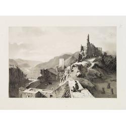
Sigmundskron (Tyrol, près de Bolzan).
Uncommon and decorative lithography published by Carl Johan Billmark and printed by Lemercier in Paris, 55 rue de Seine, the leading firm in Europe at that time. From: It...
- $60 / ≈ €53
Place & Date: Paris, c.1859

Les Trois Temples de Pestum. Royaume de Naples.
Uncommon and decorative lithography of the Temples of Paestum near Naples. Published by Carl Johan Billmark and printed by Lemercier in Paris, 55 rue de Seine, the leadin...
Place & Date: Paris, c.1859

Lac de Nemi (environs de Rome).
Uncommon and picturesque lithography of Lake Nemi, a small circular volcanic lake in the Lazio region, 30 kilometers south of Rome. Published by Carl Johan Billmark and p...
Place & Date: Paris, c.1859

Rome. Vue prise du Mont Palatin.
Uncommon and picturesque lithography of Rome. View from Mount Palatin. Published by Carl Johan Billmark and printed by Lemercier in Paris, 55 rue de Seine, the leading fi...
Place & Date: Paris, c.1859
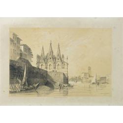
S. Maria della Spina (à Pise).
Uncommon lithography of the Church of S. Maria della Spina in Pisa. Published by Carl Johan Billmark and printed by Lemercier in Paris, 55 rue de Seine, the leading firm ...
Place & Date: Paris, c.1859

Rome (Ponte Rotto).
Uncommon and picturesque lithography of Rome with a view of the Rotto Bridge. Published by Carl Johan Billmark and printed by Lemercier in Paris, 55 rue de Seine, the lea...
Place & Date: Paris, c.1859

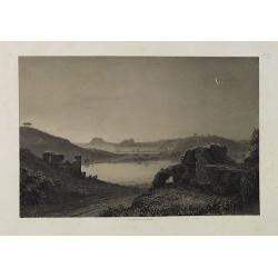
Lac de Garda Vue prise à Teno.
Uncommon and picturesque view of the Garda lake from the town of Teno. Published by Carl Johan Billmark and printed by Lemercier in Paris, 55 rue de Seine, the leading fi...
Place & Date: Paris, c.1859
Lac d'Averne (Roye. De Naples).
Uncommon and picturesque lithography of the Lake Avernus (Lago d'Averno). It was believed to be the entrance to the underworld, and is portrayed as such in the Aeneid of ...
Place & Date: Paris, c.1859
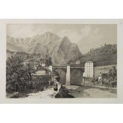
Pont du Crevola au pied de Simplon (Italie).
Uncommon and picturesque lithography of the Crevola Bridge at the foot of the Simplon Mountain in Italy. Published by Carl Johan Billmark and printed by Lemercier in Pari...
Place & Date: Paris, ca.1859

Savona Golfe de Gênes.
Uncommon and picturesque view of Sanova in the northern Italian region of Liguria in the Riviera di Ponente on the Mediterranean Sea. Published by Carl Johan Billmark and...
Place & Date: Paris, ca.1859

Rome. Les Trois colonnes de Grecostatis, et le Forum Romanum.
Uncommon and picturesque lithography of the Forum Romanum in Rome. On foreground the remains of the Temple of Castor and Pollux.Published by Carl Johan Billmark and print...
Place & Date: Paris, c.1859

Subiaco. Environs de Rome.
Uncommon and picturesque view of Subiaco in the Province of Rome, in Lazio. Subiaco is famous as it was the first city in Italy where books were printed, in the 15th cent...
Place & Date: Paris, ca.1859
Portique d'Octavie à Rome.
Uncommon and decorative lithography of the Porticus Octaviae (portico of Octavia) in Rome. Published by Carl Johan Billmark and printed by Lemercier in Paris, 55 rue de S...
Place & Date: Paris, c.1859
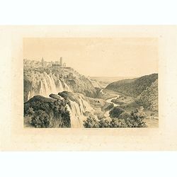
Cascatelles à Tivoli.
Uncommon and decorative lithography of the waterfalls near Tivoli.Published by Carl Johan Billmark and printed by Lemercier in Paris, 55 rue de Seine, the leading firm in...
- $100 / ≈ €88
Place & Date: Paris, c.1859
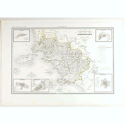
Divisione Militare di Genova. Albenga / Savona.
Very finely engraved and detailed map covering the Mediterranean coast from Oneglia, Albenga, Noli until Savona. Upper corners, two inset plans of Savona and Albenga. Key...
- $250 / ≈ €220
Place & Date: Rome, 1860
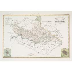
Governo di Milano / Provincia di Mantova e Cremona.
Very finely engraved and detailed map centered on Mantua, including Cremona. Lower corners two inset plans of Mantua and Cremona. Upper left corner, a key. Engraved by Ve...
- $250 / ≈ €220
Place & Date: Rome, 1860

Combat de Palestro.
Showing the battle of Palestro lithographed by E.S. Walter and printed by De Becquet and published by Rousselot in Paris.The lithograph is part of a series of prints publ...
- $100 / ≈ €88
Place & Date: Paris, ca. 1860
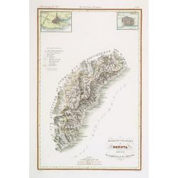
V. Compartimento Grossetano. . .
Very finely engraved and detailed map of Tuscany, centered on Grosseto. The island of Elba in left part.. In the corners insets of Sovana, Massa, Piombino, Orbetello and ...
- $200 / ≈ €176
Place & Date: Rome, 1860
Carta degla Stati Estensi avanti il domino dei Romani Sotto Il governo dei Medesimi.
Very finely engraved and detailed map of the Duchy of Lucca before the dominion of the Romans under the rule of the same and in the Middle AgesWith a key on the right par...
- $200 / ≈ €176
Place & Date: Rome, 1860
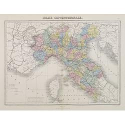
Italie Septentrionale.
A decorative map of northern Italy from Géographie Universelle, Atlas Migeon, published by J. Migeon.From one of the last decorative atlases published in the 19th centur...
- $25 / ≈ €22
Place & Date: Paris, 1874
![[Lake Garda and its surroundings].](/uploads/cache/46166-250x250.jpg)
[Lake Garda and its surroundings].
Alexey Afinogenovich Ilyin was a lieutenant general and cartographer (1832-1889). In 1856, after graduating from the Academy of the General Staff, he was at the military ...
- $100 / ≈ €88
Place & Date: St. Petersburg, 1899
