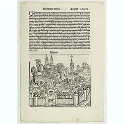
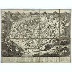
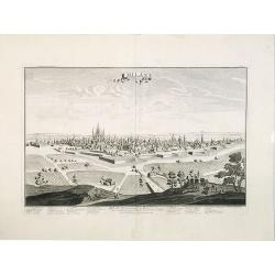
Quita Etas Mundi. Folium.LXVIII (Verona)
The Latin text page is illustrated with an imaginary of Verona, Italy. VERSO are portraits of poets and teachers.Page from the richest illustrated Incunable, the famous:...
Place & Date: Nuremberg, 12 July 1493
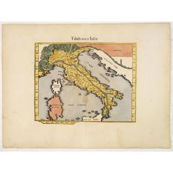
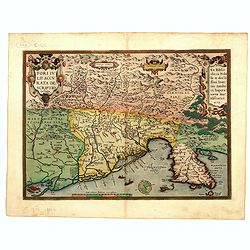
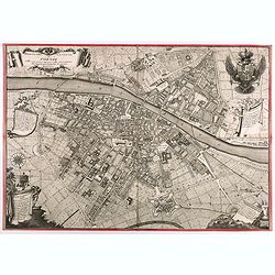
.Tabula nova Italiae. (Modern Italy)
Wood block printed modern map of Italy, prepared by Lorenz Fries and one of the earliest modern maps of Italy and environs. Based on the slightly larger map from 1513 pub...
Place & Date: Vienna, 1525 -1541
![[Toscana / Tuscany] En, candidi lectores, elegantioris Italiae partis, Tusciae scilicet, topographiam. aenis nris formis excussam in hac Tabella vobis denuo damus. . .](/uploads/cache/47717-250x250.jpg)
[Toscana / Tuscany] En, candidi lectores, elegantioris Italiae partis, Tusciae scilicet, topographiam. aenis nris formis excussam in hac Tabella vobis denuo damus. . .
A rare map of Tuscany, including the islands of Elba, Giglio, Giannutri and part of Corsica, and covering the whole of Tuscany, part of Liguria, Lombardy, Emilia, Umbria,...
- $5000 / ≈ €4402
Place & Date: Rome, ca 1557
![Amphitheatri Veronen[sis] diligens et accurata delineatio…](/uploads/cache/49136-250x250.jpg)
Amphitheatri Veronen[sis] diligens et accurata delineatio…
The print features the Amphitheater of Verona, it comes from "Speculum Romanae Magnificentiae" (The Mirror of Roman Magnificence). Example of the first state of...
- $900 / ≈ €792
Place & Date: Rome, Antonio Lafreri, ca. 1560

Pedemontanae Vicinorumque Regionum.
Fine map including the Italian coast from Monaco till Genoa. Milan in the upper righthand corner and Turin in the center of the map.
- $600 / ≈ €528
Place & Date: Antwerp, 1574-1575
Messana, Urbs est Sicilie maxima, situ, opulentia, & tuta navium statione.
Very desirable and early town-plan of Messina on Sicily, with a numbered key (1-167) in lower part. "Messina is shown from the east, in a view looking down upon the ...
- $500 / ≈ €440
Place & Date: Cologne, (1572) 1577
Veronae Urbis Territorium.
Very fine map of part of Italy centered on Verona, Vizenza and Lake Garda. Prepared by Bernardino Brugnoli, which first was published in 1574 by Forlani. Ortelius' map is...
Place & Date: Antwerp, 1584

Siciliae Veteris Typus.
A very beautiful early map of ancient Sicily. Title cartouche centered on the upper part: includes also an inset map of Syracuse in the upper left, and a list of the town...
- $600 / ≈ €528
Place & Date: Antwerp, 1587
Fori Ivlii accvrata descriptio
Map from 'Theatrum Orbis Terrarum [Atlas of the Whole World]': published in Antwerp. Provenance: This map is from the personal collection of dr. Marcel van den Bro...
Place & Date: Antwerp, 1592
Patavini territorii../ Tarvisini agri typus.. (2 maps on one sheet)
Two maps on one sheet. Map to the left is a detailed map including Venice and the area north of it, including Padua and Vincenza. Very fine map after Giacomo Gastaldi. Th...
- $300 / ≈ €264
Place & Date: Antwerp, 1598
![[View of Caorle].](/uploads/cache/45190-250x250.jpg)
[View of Caorle].
Very rare view of Caorle, at the time an island, published in the first edition of "Viaggio da Venetia, a Costantinopoli. Per Mare, e per Terra, & infieme quello...
Place & Date: Venice, Giacomo Franco, 1598
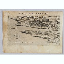
Polla Querrner [Pula in southern Istria)
Very rare view of Pula in southern Istria, published in the first edition of "Viaggio da Venetia, a Costantinopoli. Per Mare, e per Terra, & infieme quello di Te...
Place & Date: Venice, Giacomo Franco, 1598
![[San Nicola, Tremiti islands, in Italy. ]](/uploads/cache/45204-250x250.jpg)
[San Nicola, Tremiti islands, in Italy. ]
Very rare view of San Nicola, Tremiti islands, in Italy, published in the first edition of "Viaggio da Venetia, a Costantinopoli. Per Mare, e per Terra, & infiem...
Place & Date: Venice, Giacomo Franco, 1598
![[ View of Cruzola]](/uploads/cache/45205-250x250.jpg)
[ View of Cruzola]
Very rare view of Tremite Islands Island published in the first edition of "Viaggio da Venetia, a Costantinopoli. Per Mare, e per Terra, & infieme quello di Terr...
Place & Date: Venice, Giacomo Franco, 1598
![[ View of Ragusi]](/uploads/cache/45206-250x250.jpg)
[ View of Ragusi]
Very rare view of Ragusa published in the first edition of "Viaggio da Venetia, a Costantinopoli. Per Mare, e per Terra, & infieme quello di Terra Santa. Da Gios...
Place & Date: Venice, Giacomo Franco, 1598
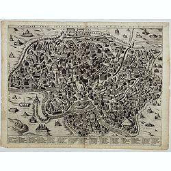
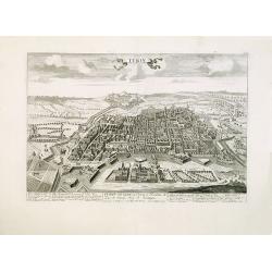
Antiquae urbis perfecta et Nova delineatio. [ Ancient Rome)
First state before imprint of Jacobus de Rubeis. A rare view of Ancient Rome from the Lafreri-School in the style of Ambrogio Brambilla's view of about 1575. A unique opp...
Place & Date: Rome, ca. 1600
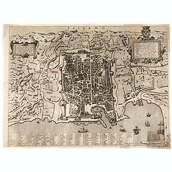
Palermo.
Rare bird's-eye view of Palermo, the plan showing the city and harbor within the city walls, with the surrounding countryside, title and dedicatory verse set in elaborate...
- $3000 / ≈ €2641
Place & Date: Seina, ca. 1600
![FIORENZA [FLORENCE].](/uploads/cache/49141-250x250.jpg)
FIORENZA [FLORENCE].
State 2 of this bird's-eye view of Florence. In the center, under the upper border, the engraved title "Fiorenza". At the top left, a compass rose is represente...
- $2000 / ≈ €1761
Place & Date: Siena, Pietro Petrucci, ca. 1600
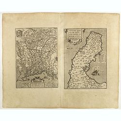
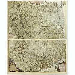
![Larii Lacus Vulgo Comensis Descriptio . . . [and] Terretorii Romani Descrip. [and] Fori Iulii Vulgo Frivli Typus. . .](/uploads/cache/48574-250x250.jpg)
Larii Lacus Vulgo Comensis Descriptio . . . [and] Terretorii Romani Descrip. [and] Fori Iulii Vulgo Frivli Typus. . .
Set of 3 maps of Lake Como, the region around Rome and the region around the Upper Adriatic, centered on Udinese from 'Theatrum Orbis Terrarum [Atlas of the Whole World]...
Place & Date: Antwerp, 1609/1612
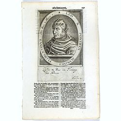
Leo X. Pontifex Maximus Florentinus Sedit Annos 8 Menses 8. / Paulus Quartus Neapolitanus Pontifex Maximus..
The engraving depicts a half length oval portrait of the Pope "Leo X", signed lower right corner N. de Cleck".On verso a half length oval portrait of "...
- $15 / ≈ €13
Place & Date: Amsterdam, Cloppenburch, 1621
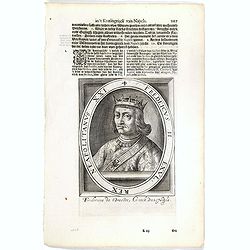
Fredeicus II. EXVL, Rex eapoltanus XXI.
The engraving depicts a half length oval portrait of "Fredericus II" and on the verso a portrait of "Ferdinandus V".Nicolaes de Clerck (de Klerc) was ...
- $20 / ≈ €18
Place & Date: Amsterdam, Cloppenburch, 1621
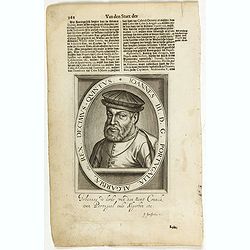
Ionnes III. D. G. Portugaliae Algarbiae etc. Rex. Decimus- Quintus / Fredeicus. II. Exul, Rex Neapolitanus XXI.
The engraving depicts a half length oval portrait of Naples King Fredericus. II and Portuguese King Iohannes III..Nicolaes de Clerck (de Klerc) was active as engraver and...
- $45 / ≈ €40
Place & Date: Amsterdam, Cloppenburch, 1621

Mantua ducatus.
Originally engraved for Jodocus Hondius II, at his death in August 1629 this map was, among 39 other copper plates, purchased by Willem Blaeu who deleted Hondius' name an...
- $300 / ≈ €264
Place & Date: Amsterdam, 1634

Mantua ducatus.
Important map of northern Italy centered on the dramatic fortress of Mantua.
- $300 / ≈ €264
Place & Date: Amsterdam, 1635

Mantua ducatus.
Centered at the town of Mantua.As Willem Blaeu died in 1638 most of his maps are actually published by his son Joan. This map carries his (engraved) signature and was act...
Place & Date: Amsterdam, 1638
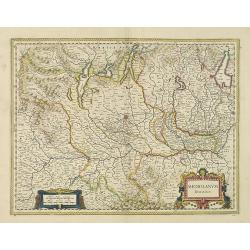
Mediolanum Ducatus.
Very fine map centered on Milan Including Lake Como, Lake Garda, Lake Majore, Parma, etc.As Willem Blaeu died in 1638 most of his maps are actually published by his son J...
Place & Date: Amsterdam, 1638
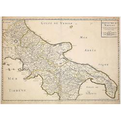
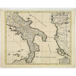
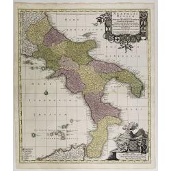
Royaume de Naples..
Fine map of the southern part of Italy.This edition carries the date 1648, engraved by AB. De la plaets. With the manuscript number in the upper right corner.Nicolas Sans...
Place & Date: Paris, 1648
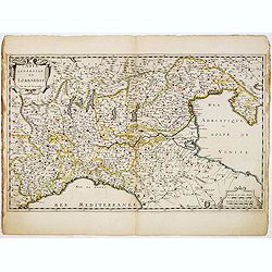
Carte Générale de Lombardie.
Fine map of Northern and middle part of Italy, engraved by A Peyrouin. According to the credit in the cartouche the map has been prepared by Pierre Duval.
- $300 / ≈ €264
Place & Date: Paris, ca. 1650

Le Royaume de Sicile.
Uncommon map Sicily and part of Palermo. Very good impression.Like Sanson, Briet was born in Abbeville and became a Jesuit at age 18. His "Parallela Geographiae Vete...
Place & Date: Paris, 1653
![Nova & exacta Chorographia Latii sive Territorii Romani iuxta veterem et novum situm parallela nomimu[m] comparatione elaborata.](/uploads/cache/44863-250x250.jpg)
Nova & exacta Chorographia Latii sive Territorii Romani iuxta veterem et novum situm parallela nomimu[m] comparatione elaborata.
Map of central Italy, centered on Rome from "Latium" by A. Kircher and designed by Innocenzo Mattei. The title cartouche in the lower right, small legend with 1...
Place & Date: Amsterdam, 1671

Histoire de la République de Venise.
The History of the Republic of Venice Historia della Republica Veneta (dal 1613 al 1671), in Italian, which goes from 1613 to 1671, was translated by François Tallemant,...
- $1800 / ≈ €1585
Place & Date: Cologne, Pierre Marteau, 1682
L'Italie distinguee suivant l'estendue de tous les estats. . .
Fine map of Italy with a decorative title and scale cartouche.Alexis-Hubert Jaillot (1632-1712), was a French cartographer. He joined the Sanson heirs and redrew Nicolas ...
- $500 / ≈ €440
Place & Date: Amsterdam, 1692
Le royaume de Naples divise en 12 provinces.
Fine map of Royaume of Naples with a decorative title and scale cartouche.Alexis-Hubert Jaillot (1632-1712), was a French cartographer. He joined the Sanson heirs and red...
Place & Date: Amsterdam, 1692
Principaute de Piemont Seigneurie de Verceil... Principauté d'Oneglia... Le Comté de Nice le Marquisat de Salusse et Principauté de Monaco.
This very spectacular engraved map of the Comté de Nice et Principauté de Monaco has very spectacular coloring and lettering heightened in gold.The style is similar to ...
Place & Date: Paris, 1693
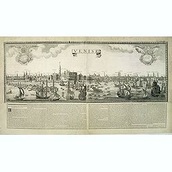
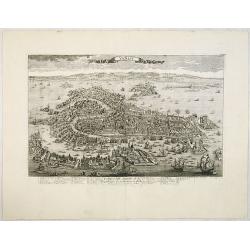
Venise. 1700
Extremely rare panoramic broad sheet panoramic town-view of Venice with underneath in letter press a description of the town's history. The view measures more than 1 mete...
Place & Date: Paris, 1699
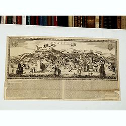
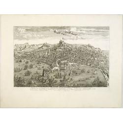
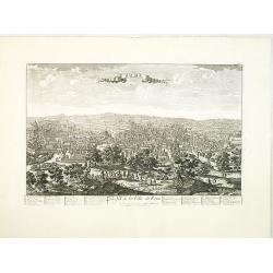
Naples. 1699. Nouvelle et exacte description de la tres-celebre & ancienne Ville de NAPLES
Only recorded broad sheet panoramic view of Naples with underneath in letter press a description of the town's history : "Nouvelle et exacte description de la tres-c...
Place & Date: Paris, 1699
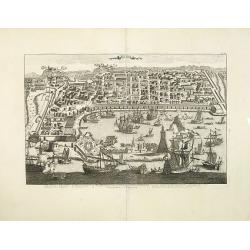
Plaisance ou Piacensa, ville de la Lombardie, capitale du duché de Plaisance.
Rare and beautiful bird's-eye plan of the town of Plaisance in Lombardy, accompanied by 120 key to the most important points in town. Second state with " XIX" i...
- $400 / ≈ €352
Place & Date: Amsterdam, 1704
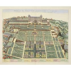
Hortus et Palatium Atestinorum Tyburi.
Showing in great detail the hortus and gardens of Villa Tivoli.Joan Blaeu published during his life three town-books of Italy: Citta del Vaticano, Roma and Napoli. By the...
Place & Date: Amsterdam, 1705
Carte du gouvernement militaire de la République de Venise . . .
Very decorative folio sheet with five engraved views in Venice: "Vue de la Palace de St. Marc" (Piazza San Marco), a birds-eye map of "L'Arcenal", &qu...
Place & Date: Amsterdam, 1720

L'Italie dans son Premier Etablissement sous la Republique Romaine. . .
Map of Italy when first established under the Roman Republic after the division by Ayuguste Caesar, its various Papal governments: ancient Rome and its surround dings, a ...
Place & Date: Amsterdam, 1728
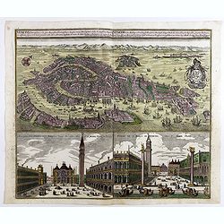
Iconografica Rappresentatione della Inclita Città di Venezia Consacrata al Reggio Serenissimo Domino Veneto.
The extremely rare first state of Ughi's Wall Map of Venice published by Giuseppe Baroni in 1729. - Ughi's map of Venice is one of the largest maps of Venice ever publish...
- $75000 / ≈ €66037
Place & Date: Venice, Giuseppe Baroni á S. Giuliano, 1729
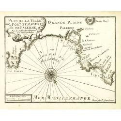
Plan de la Ville, Port et rades de Palerme. . .
An attractive chart centered on Palermo. With scale and large compass-rose. Dated 1727, with the privilege of the King. From : Recueil des Plusieurs plans des ports et ra...
- $250 / ≈ €220
Place & Date: Marseille, 1730

Plan du Port de Trapano et des isles Favouillane.
An attractive chart centered on Trapani on the west coast of Sicily in Italy. It is the capital of the Province of Trapani. The right the island of Favignana and Levanzo ...
- $300 / ≈ €264
Place & Date: Marseille, 1730

Plan du Golfe de Naples.
An attractive chart centered on the Gulf of Naples. Mount Vesuvius to the right. With scale and large compass-rose. Dated 1727, with the privilege of the King. From : Rec...
- $350 / ≈ €308
Place & Date: Marseille, 1730
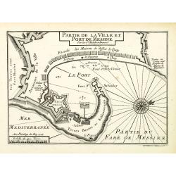
Plan de la Ville et Port de Messine.
An attractive chart centered Messina on Sicily. With scale and large compass-rose. Dated 1727, with the privilege of the King. From : Recueil des Plusieurs plans des port...
- $250 / ≈ €220
Place & Date: Marseille, 1730
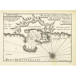
Plan de la Ville et Port de Civita-Vechia.
An attractive chart centered on Civitavecchia, a town and comune of the province of Rome in the central Italian region of Lazio.With scale and large compass-rose. Dated 1...
- $200 / ≈ €176
Place & Date: Marseille, 1730

Plan de Porto Ferraro en l'isle de l'Elbe.
An attractive chart centered on the Mediterranean. With scale and large compass-rose. Dated 1727, with the privilege of the King. From : Recueil des Plusieurs plans des p...
- $200 / ≈ €176
Place & Date: Marseille, 1730
Venetia potentissima e la più magnifica fiorentissimae la più ricca città capitale della Serenissima repubblica . . .
Birds-eye plan view of Venice, depicting the city's architectural landmarks. Below Saint Marco square.Matthaus Seutter the elder first published his "Atlas Geographi...
Place & Date: Augsburg, 1730
Neapolis Regnum . . .
Map of the region from Naples to Calabria. Cartouche representing Vesuvius erupting.Matthaus Seutter the elder first published his "Atlas Geographicus" in 1720 ...
Place & Date: Ausburg, 1730
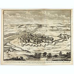
A view of Cassel, a very strong city in Italy, taken by the Duke of Savoy in Decem.r 1706
An interesting copper engraved plan of the Fortification of Cassel in Italy, with an attractive rococo cartouche, showing an overview of the battlefield and surrounding a...
Place & Date: London, 1743
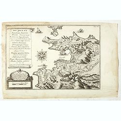
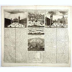
Hic Jacent Puteolorum Bajarum, Miseni Cumarium. . .
A bird's-eye view of Puzzoli and environs, depicting fascinating topographical and architectural features of interest. Title cartouche describes the map and area in Latin...
- $80 / ≈ €70
Place & Date: London, 1725-1744
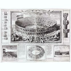
Anfiteatro detto l'Arena di Verona.
Large two sheet copper engraving of the Amphitheater of Verona after a design of Adriano Cristofali. On three sides it is surrounded by architectural details interspersed...
- $2200 / ≈ €1937
Place & Date: Verona, 1744

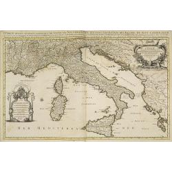
Regionum Italiae mediarum Tabula Geographica. . .
Fine historical map of central Italy with Tuscany, centered on Rome, in the south Pompeii, in the top the island of Giglio and the town Orbetello. Lower left inset plan o...
- $150 / ≈ €132
Place & Date: Paris, 1745

Carte Générale de l'Etat de Gênes.
Detailed map centered on the Gulf of Genoa. It shows the Italian region Liguria and extends westwards as far as Nice.Key map for the nine large-scale maps de Vaugondy mad...
- $100 / ≈ €88
Place & Date: Paris, ca. 1748

VI. Carte des Confins de l'Etat de Gênes où sont Novi, Gavi, et Ottagio..
Detailed small map encompassing the part of Piedmont between Alessandria, Tortona and Novi Ligure.Relief shown pictorially. From Atlas Portatif Universel, by Robert de Va...
- $150 / ≈ €132
Place & Date: Paris, later than 1748
![VIII. Carte de l'Etat de Genes [. . .] Toscane.](/uploads/cache/24551-250x250.jpg)
VIII. Carte de l'Etat de Genes [. . .] Toscane.
Detailed small map showing an area straddling the provinces of Genoa, La Spezia, Parma and Massa Carrara, Tuscany.Relief shown pictorially. From Atlas Portatif Universel,...
Place & Date: Paris, later than 1748
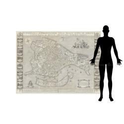
Venise / Ville capitale de la République de même nom en Italie.
A very decorative and extremely rare town plan of Venice, including a numbered legend in the lower part. Published by Jacques Chéreau, (1688 - 1776). Engraved by Pierre-...
- $4000 / ≈ €3522
Place & Date: Paris, ca.1750
Naples, Ville de la Province de Labour, Archiépiscopale, et Capitale du Royaume de Naples.
A very decorative and extremely rare view of Naples, including a numbered (1-18) key in the lower part. Published by Jacques Chéreau, (1688 - 1776). Engraved by Aveline ...
- $3500 / ≈ €3082
Place & Date: Paris, ca.1750
Messine. Anciennement Messena Ville . . .
A very decorative and extremely rare view of Messina on Sicily, including a numbered (1-16) key in lower part. Published by Jacques Chéreau, (1688 - 1776). Engraved by A...
- $3000 / ≈ €2641
Place & Date: Paris, ca.1750
Rome. Profil de la Ville de Rome.
A very decorative and extremely rare town view of Rome, including a numbered key ( 1-47 ), in lower part. The Vatican with St.Pierre in the left, with great detail. Publ...
- $3300 / ≈ €2906
Place & Date: Paris, ca.1750
Milan. Ville forte, Capitale du Duché de même nom, l'une des plus grandes des des plus considérables de l'Italie.
A very decorative and extremely rare of Milan, including a numbered key ( 1-35 ) in lower part. Published by Jacques Chéreau, (1688 - 1776). Engraved by Aveline and fir...
- $3500 / ≈ €3082
Place & Date: Paris, ca.1750
Turin. Ville Capitale du Piemont et Residence du Duc de Savoye Roy de Sardigne.
A very decorative and extremely rare town-view of Turin, including a numbered key ( 1- 28 ) in lower part. Published by Jacques Chéreau, (1688 - 1776). Engraved by Pierr...
- $2500 / ≈ €2201
Place & Date: Paris, ca.1750
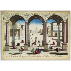
Arc de Triomphe ou se passe la proscription d'Octave et d'Antoine.
J. Chereau was a publisher of optical prints, established in Paris, rue St.Jacques.In the eighteenth and nineteenth centuries, there were many popular specialty establish...
- $200 / ≈ €176
Place & Date: Paris, ca. 1750
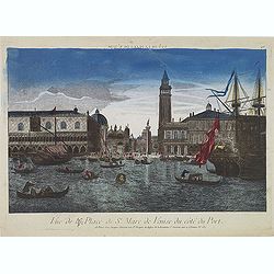
Vue de la Place de St Marc de Venise du côté du port.
Optical print showing the Doge's Palace (Palazzo Ducale), San Marco Square, and Saint Mark's Basilica (Basilica di San Marco in Venice, as seen from the waterside. The im...
- $300 / ≈ €264
Place & Date: Paris, ca. 1750
Vue de l'Entree de la Cour.. de la rue de l'Arno a Florence
So-called optical print of Arno Street in Florence, in Tuscany region. Probst was the best-known publishers of optical prints, established in Augsburg.In the eighteenth ...
- $150 / ≈ €132
Place & Date: Augsburg 1750
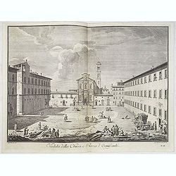
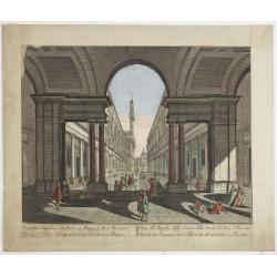
Veduta della Chiesa e Piazza d'Ognissanti.
Lively view of Piazza Ognissanti in Florence after Giuseppe Zocchi (1711or 1717 - 1767) and engraved by Giuseppe Papini. From "Scelta di XXIV Vedute delle principali...
- $500 / ≈ €440
Place & Date: Florence, Bouchard, 1754
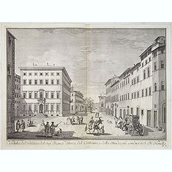
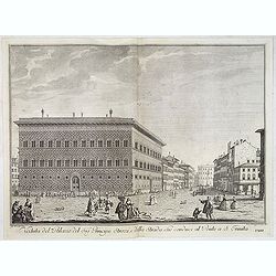
Veduta del Palazzo del Sig.re Marchese Strozzi, del Centauro e della Strada che conduce a S. Maria Novella.
Lively view of a square with the Palace of the Marquis Strozzi of Florence after Giuseppe Zocchi (1711or 1717 - 1767) and engraved by B.Sgrilli. From "Scelta di XXIV...
- $500 / ≈ €440
Place & Date: Florence, Bouchard, 1754
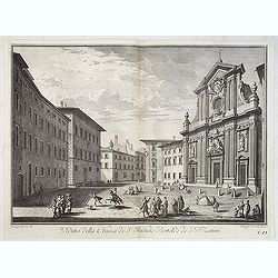
Veduta della Chiesa di S. Michele Bertelde de' PP. Teatini.
Lively view of a square with the Church of Santi Michele e Gaetano in Florence after Giuseppe Zocchi (1711or 1717 - 1767) and engraved by B.Sgrilli. From "Scelta di ...
- $500 / ≈ €440
Place & Date: Florence, Bouchard, 1754
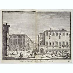
Veduta de' Palazzi de' Sig. March. Corsi e Viviani.
Lively street scene with several palaces in Florence after Giuseppe Zocchi (1711or 1717 - 1767) and engraved by Mich. Mariesschi and Vincenzo Francesschini. From "Sc...
- $500 / ≈ €440
Place & Date: Florence, Bouchard, 1754
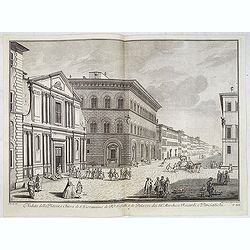
Veduta del Palazzo del Sig.re Principe Strozzi, e della strada che conduce al Ponte a S. Trinita.
Lively street scene with the palace of Mr. Strozzi in Florence after Giuseppe Zocchi (1711or 1717 - 1767) and engraved by Bal. Gabbuggiami from Rome. From "Scelta di...
- $750 / ≈ €660
Place & Date: Florence, Bouchard, 1754
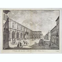
Veduta dello Spedale, e della Piazza di S. Maria Nuova.
Lively view of a square in Florence after Giuseppe Zocchi (1711or 1717 - 1767) and engraved by B.Sgrilli. From "Scelta di XXIV Vedute delle principali contrade, piaz...
Place & Date: Florence, Bouchard, 1754
Veduta della Piazza, e Chiesa di S. Giovannino de' PP. Gesuiti, e de' Palazzi de' SS.ri Marchese Riccardi, e Panciatichi.
Lively street scene showing all the buildings aligned with Palazzo Medici Riccardi as far as the end of the road. The effect is that of a more imposing theatricality, wit...
- $500 / ≈ €440
Place & Date: Florence, Bouchard, 1754
Pianta Della Citta di Firenze nelle seu vere misure colla descrizione dei luoghi piu notabili di ciascun Quartiere.
A highly decorative plan of Florence by Ferdinando Ruggieri. In addition to the detailed plan of the City, it includes fine decorative embellishments and demonstrates the...
Place & Date: Florence, 1755
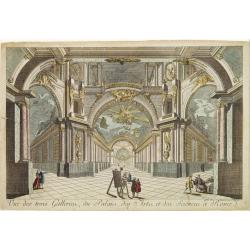
Vue des trois Gallerie, du Palais des Arts..Science a Rome.
So-called optical print. Daumont was a well-known publisher of optical prints, established in Paris. In the eighteenth and nineteenth centuries there were many popular sp...
Place & Date: Paris, 1760
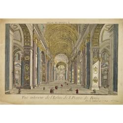
Vue interieur de l'Eglise de S.Pierre de Rome.
So-called optical print of St. Pieter church of Rome. A well-known publisher of optical prints, established in Paris. In the eighteenth and nineteenth centuries there wer...
Place & Date: Paris, 1760
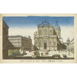
Eglise et place de Saint Andre dellavalle à Rome.
Perspective view of the church and place Sant'Andrea della Valle church in Rome. Sant'Andrea della Valle later became a model for the construction of other churches like ...
Place & Date: Paris, 1760
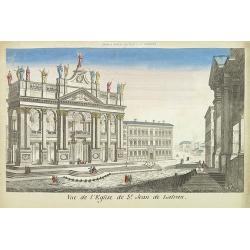
Vue de l'eglise de St Jean de Latran.
So-called optical print of the church Saint Jean de Latran, by Basset a well-known publisher of optical prints, established in rue St.Jacques in Paris. With brief key lis...
- $150 / ≈ €132
Place & Date: Paris, 1760
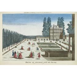
Maison de plaisance près de Parme.
So-called optical print of a country house near Parma, by the well-known publisher of optical prints, Basset, established in rue St.Jacques in Paris.In the eighteenth and...
- $150 / ≈ €132
Place & Date: Paris, 1760
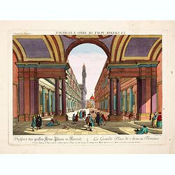
Prospect des grossen Arno Platzes in Florenz.
Rare so-called optical print illustrating a Street scene in Florence with the Palazzo Vecchio (town hall) and its Duomo (cathedral) in the background. Engraved by Balth F...
- $250 / ≈ €220
Place & Date: Augsburg, 1760
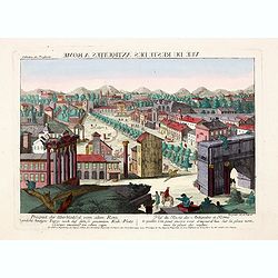
Prospect der Überbleibssel von altem Rome. - Vue du Reste des Antiquites a Rome.
A rare so-called optical print illustrates Roman Forum, ancient Rome's showpiece center, a grandiose district of marble-clad temples, proud basilicas and vibrant public s...
- $250 / ≈ €220
Place & Date: Augsburg, 1760