Browse Listings in Europe > Greece > Greek Islands
![[Euboe].](/uploads/cache/41989-250x250.jpg)
[Euboe].
Woodcut Ptolemaic-style map by Sebastian Münster figuring Euboea Island, published in the edition of Strabo by Henri Petri in 1571."Strabonis rerum geographicarum&q...
- $100 / ≈ €88
Place & Date: Basle, Henri Petri, 1571
![Zafalonia [Map of Kefalonia]](/uploads/cache/45223-250x250.jpg)
Zafalonia [Map of Kefalonia]
Very rare map of the island of Kefalonia published in the first edition of "Viaggio da Venetia, a Costantinopoli. Per Mare, e per Terra, & infieme quello di Terr...
- $450 / ≈ €396
Place & Date: Venice, Giacomo Franco, 1598
![[Map of Zakynthos or Zante]](/uploads/cache/45226-250x250.jpg)
[Map of Zakynthos or Zante]
Very rare map of Zakynthos or Zante, a Greek island in the Ionian Sea. It is the third largest of the Ionian Islands. Published in the first edition of "Viaggio da V...
- $450 / ≈ €396
Place & Date: Venice, Giacomo Franco, 1598
![[Map of Morea]](/uploads/cache/45228-250x250.jpg)
[Map of Morea]
Very rare map of the island Morea published in the first edition of "Viaggio da Venetia, a Costantinopoli. Per Mare, e per Terra, & infieme quello di Terra Santa...
- $450 / ≈ €396
Place & Date: Venice, Giacomo Franco, 1598
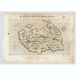
Murgo.
Very rare map of Amorgos published in the first edition of "Viaggio da Venetia, a Costantinopoli. Per Mare, e per Terra, & infieme quello di Terra Santa. Da Gios...
- $300 / ≈ €264
Place & Date: Venice, Giacomo Franco, 1598
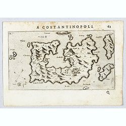
Millo.
Very rare view of Milos Island published in the first edition of "Viaggio da Venetia, a Costantinopoli. Per Mare, e per Terra, & infieme quello di Terra Santa. D...
- $450 / ≈ €396
Place & Date: Venice, Giacomo Franco, 1598

Rhodi.
A beautiful miniature map of the Greek island of Rhodes, published by Petrus Bertius in Amsterdam at the beginning of the seventeenth century.Engraved by Petrus Kaerius. ...
Place & Date: Amsterdam, 1606

Morea olim Peloponnesus.
Gerard Mercator's map of the Greece's Peloponnesus peninsula called and labeled Morea. A few of the other smaller islands appear included the larger Cerigo (today's Cythe...
- $300 / ≈ €264
Place & Date: Amsterdam, 1630

Candie.
Rare map of Crete with in top six small inset maps of Greek islands, published by Jollain in 1667. Published in "Trésor Des Cartes Geographiques Des Principaux Esta...
- $350 / ≈ €308
Place & Date: Paris, 1667

Moree jadis Peloponese.
Rare map of Peloponnese, published by Jollain in 1667. Published in "Trésor Des Cartes Geographiques Des Principaux Estats de Lunivers".This atlas is based upo...
- $300 / ≈ €264
Place & Date: Paris, 1667

Insula Candia ejusque fortificatio.
An earlier and smaller version of De Wit's map of Candia. Richly engraved work, one of the most beautiful ever produced of Crete. There are insets of the fortifications a...
- $2500 / ≈ €2201
Place & Date: Nuremberg, 1680

Peloponnesus Hodie Morea Ad Normam Veterum Et Recentiorum Mappa Accuratissime Adornata Aeri Incisa Et Venalis. . .
Decorative regional map of Morea and contiguous islands, with an ornate cartouche showing a lion bearing a sword defeating Turkish and other invaders.
- $450 / ≈ €396
Place & Date: Augsburg, 1740
![[56] I.Scio.](/uploads/cache/12828-250x250.jpg)
[56] I.Scio.
"Charming chart of the harbour of the Greek town of Chios. Showing town and harbour plan, with soundings, anchorages, rocks, shoals, fortifications and lighthouses.J...
- $80 / ≈ €70
Place & Date: Marseille, 1764

Graeciae pars septentrionalis. . .
Rare map of northern part of Greece and part of Turkey, prepared by Nolin and published by L.J. Mondhare for his Atlas Général a l'usage des colleges et maisons d'educa...
- $80 / ≈ €70
Place & Date: Paris, 1781

Provincia ecclesiastica di Naxos e delegazione aplica di Grecia. (Tav XCVII)
A large-format map of Naxos with it's dioceses. This Greek island in the South Aegean, is the largest of the Cyclades island group. The map is finely engraved and beautif...
- $250 / ≈ €220
Place & Date: Rome, 1858

Provincia ecclesiastica di Corfu nell isole Jonie. Tav. XCV.
A large-format map centered on Corfu with it's dioceses. The map is finely engraved and beautifully colored and was prepared by Girolamo Petri, a lawyer who served as a s...
- $450 / ≈ €396
Place & Date: Rome, Tipografia della Reverenda Camera Apostolica, 1858-1859