
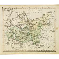
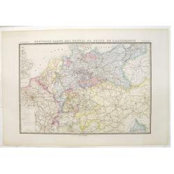
Cercle de Baviere où se trouvent le Palatinat de Baviere et l'Archev. De Saltzbourg.
Small detailed map of the southeastern part of Bavaria, including part of Austria. From Atlas Portatif Universel, by Robert de Vaugondy.Edited by : "Au dépôt de G�...
- $30 / ≈ €26
Place & Date: Paris, 1799
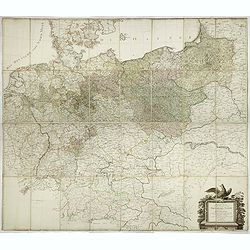
General Karte von den saemtlichen Kšnig. Preussischen Staaten welche zugleich als POSTKARTE durch die Länder der Preussischen Monarchie und durch ganz Deutschland diendt. . .
Large wall map (1,25 x 1,38 meters) of Prussia and present-day Poland, prepared by D.F. Sotzmann and published by Königl. Preuss. Academie Kunst und Buchhandlung.A detai...
- $1500 / ≈ €1321
Place & Date: Berlin, 1802

Cercle de Haute Saxe et de Basse Saxe. . .
Map of the duchies of Saxony (upper & lower). By C. F. Delamarche, successor of Robert de Vaugondy, Geographer.
- $50 / ≈ €44
Place & Date: Paris, 1794 - 1806

L'Allemagne . . .
Map of Germany, from Atlas moderne portatif composé de vingt-huit cartes sur toutes les parties du globe terrestre .. A l'usage des Colléges, des Pensions & des Mai...
- $50 / ≈ €44
Place & Date: Paris, Prudhomme, Levrault, Debray, 1806

Carte d'Allemagne et de la Republique Helvetique.
Map of central Europe centered on Germany, extending southwards and eastwards to include Poland, the Czech Republic, Austria, Switzerland, Slovenia and part of Italy.From...
Place & Date: Paris, Prudhomme, Levrault, Debray, 1806

Femme d'Ausbourg.
Originally hand-colored mezzotint from 'Costumes civils actuels de tous les peuples connus'. After Jacques Grasset de Saint-Sauveur. As an etcher, drawer and writer, Gras...
- $50 / ≈ €44
Place & Date: Paris,1806
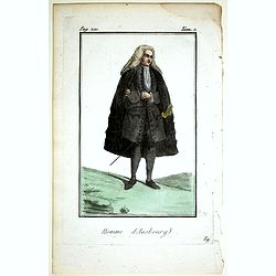
Homme d'Ausbourg.
Originally hand-colored mezzotint from 'Costumes civils actuels de tous les peuples connus'. After Jacques Grasset de Saint-Sauveur. As an etcher, drawer and writer, Gras...
- $50 / ≈ €44
Place & Date: Paris,1806
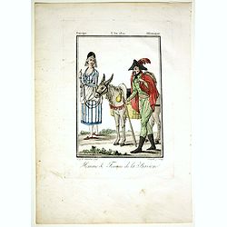
Homme & Femme de la Baviere.
Originally hand-colored mezzotint from 'Costumes civils actuels de tous les peuples connus'. Engraved by Félix Mixelle after Jacques Grasset de Saint-Sauveur.As an etche...
- $50 / ≈ €44
Place & Date: Paris,1806

Deutschland (with Poland)
Nice small map of Germany by Johannes Walch in his rare Allgemeiner Atlas Nach den bewährsten Hülfsmitteln und astronomischen Ortsbestimungen…, edition of 1812.Johann...
- $75 / ≈ €66
Place & Date: Augsburg, 1812

Westphalen.
Nice small map of Westphalia in Germany by Johannes Walch in his rare Allgemeiner Atlas Nach den bewährsten Hülfsmitteln und astronomischen Ortsbestimungen…, edition ...
- $50 / ≈ €44
Place & Date: Augsburg, 1812
Brandenburg und Pommern.
Nice small map of Brandenburg and Pommeren, centered on Berlin by Johannes Walch in his rare Allgemeiner Atlas Nach den bewährsten Hülfsmitteln und astronomischen Ortsb...
- $75 / ≈ €66
Place & Date: Augsburg, 1812

General Charte der Preussischen Monarchie in zwey Blattern. . .
Uncommon and detailed map of Kingdom of Prussia with present day Poland and Germany. Uncommon map engraved by Ludwig Hess and published in Weimar by Fr. Wilhelm Streit.
- $1000 / ≈ €880
Place & Date: Weimar, 1812
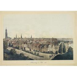
Hamburg im Jahre 1813
Decorative lithographed view of Hamburg. The print is issued in colors but finished by hand.
- $150 / ≈ €132
Place & Date: Germany,1820
![[No tittle] Partie de la Prusse.](/uploads/cache/30632-250x250.jpg)
[No tittle] Partie de la Prusse.
Detailed map of the south of Baltic Sea. With a paper printed label of the Paris map seller Jean Goujon who was active from 1793-1826. The label carries the address of Ru...
- $90 / ≈ €79
Place & Date: Paris, c. 1820

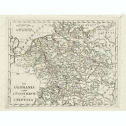
La germania con i Paesibassi e l'elvezia.
Charming map of Germany, The Netherlands, Switzerland and part of Poland from the rare atlas Atlante Tascabile o sia Serie di Num. XXI Cartine Geografiche nelle quali si ...
- $80 / ≈ €70
Place & Date: Rome, 1823
La germania con i paesi bassi e l'elvezia.
Charming map of Germany, Netherlands, Switzerland, Austria from the rare atlas Atlante Tascabile o sia Serie di Num. XXI Cartine Geografiche nelle quali si rappresenta in...
- $65 / ≈ €57
Place & Date: Rome, 1823

Allemagne . . .
Detailed map of Germany and Austria, prepared by A. H. Basset, rue Saint-Jacques, no. 64, Paris and published in Atlas classique et Universel de Géographie . . . .The en...
- $80 / ≈ €70
Place & Date: Paris, A.H. Basset, 1828
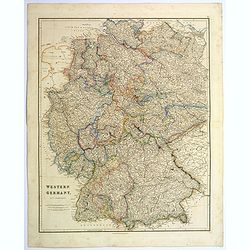
Western Germany.
A lovely, large steel engraved map of Western Germany. Some of the states engraved are: Holstein, Hannover, Mecklenburg, Saxony, Bavaria, Württemberg and Nassau. An extr...
Place & Date: London, 1839

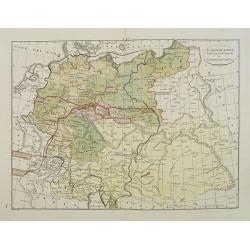
Prussia & Poland.
A glorious, large steel engraved map of Prussia and Poland. Some of the states covered are: Saxony, Pomerania, Posen, Brandenburg, Western & Eastern Prussia and the K...
Place & Date: London, 1839
L'Alemagna . . .
A rare double-page map of Germany and Poland. Prepared by Las Casas and engraved by G.V.Pasquali for l'Atlante Storico, Letterario, Biografico, Archeologico. . . with at...
- $50 / ≈ €44
Place & Date: Venice, 1840
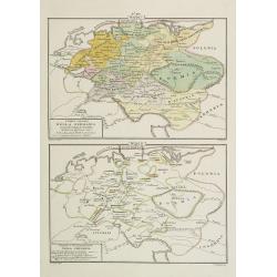
I dieci circoli Della Germania . . . / Permute e Secolarizzazioni Nella Germania . . .
Two rare maps of Germany: Top map: 160 x 235mm. Bottom map: 160 x 235mm.Prepared by Las Casas for l'Atlante Storico, Letterario, Biografico, Archeologico. . . with attri...
- $30 / ≈ €26
Place & Date: Venice, 1840

La Germania, suoi ducati e dependenze . . . /Origine e derivazione de principali stati . . .
Two rare maps of ancient Germany: Top map: 160 x 235mm. Bottom map: 160 x 235mm.Prepared by Las Casas for l'Atlante Storico, Letterario, Biografico, Archeologico. . . wi...
- $25 / ≈ €22
Place & Date: Venice, 1840
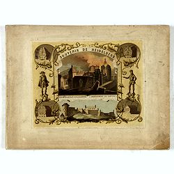
(Title page) Souvenir de Heidelberg.
Cover for a souvenir album with chromolithographed design and entitled: Souvenir de Heidelberg prepared by Louis Charles François. He emigrated with his family in May 17...
- $50 / ≈ €44
Place & Date: Graimberg, Heidelberg, ca. 1840

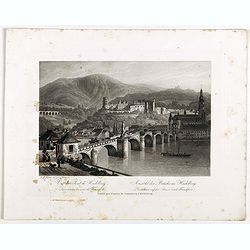
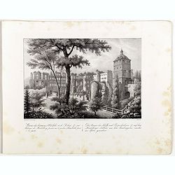
Ansicht der Heidelberger Schlosses. . .
Early lithograph published by Louis Charles François de Graimberg-Belleau. Lithographed by C.F Müller.French artist. Son of Gilles-François Belleau Graimberg. Louis Ch...
Place & Date: Graimberg, Heidelberg, ca. 1840

Vue de la porte Charles. . . Ansicht ded Karlthors . . .
Early aquatint after Louis Charles François de Graimberg-Belleau. Engraved by J.J Tanner.French artist. Son of Gilles-François Belleau Graimberg. Louis Charles Françoi...
Place & Date: Graimberg, Heidelberg, ca. 1840
Vue du pont de Heidelberg. Ansicht der Brücke in Heidelberg.
Early aquatint after Louis Charles François de Graimberg-Belleau. Engraved by J.J Tanner.French artist. Son of Gilles-François Belleau Graimberg. Louis Charles Françoi...
Place & Date: Graimberg, Heidelberg, ca. 1840

Vue de Heidelberg . . . Ansicht von Heidelberg . . .
Early aquatint after Louis Charles François de Graimberg-Belleau. Lithographed by J.J Tanner.French artist. Son of Gilles-François Belleau Graimberg. Louis Charles Fran...
Place & Date: Graimberg, Heidelberg, ca. 1840
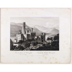
Vue du château de Stolzenfels . . . Ansicht des Schlofses Stolzenfels . . .
Early aquatint after Louis Charles François de Graimberg-Belleau. Lithographed by J.J Tanner.French artist. Son of Gilles-François Belleau Graimberg. Louis Charles Fran...
Place & Date: Graimberg, Heidelberg, ca. 1840

Das grofse Fafs au Heidelberg . Le gros tonneau de Heidelberg.
Engraving after Louis Charles François de Graimberg-Belleau. Engraved by J.J Tanner.French artist. Son of Gilles-François Belleau Graimberg. Louis Charles François emi...
Place & Date: Graimberg, Heidelberg, ca. 1840

Nördlicher Theil des Heidelberg schlosses. Vue de la partie du nord du château de Heidelberg.
Early lithographs after Louis Charles François de Graimberg-Belleau. Lithographed by C.F Müller.French artist. Son of Gilles-François Belleau Graimberg. Louis Charles ...
Place & Date: Graimberg, Heidelberg, ca. 1840

Nördlicher Theil des Heidelberger schlosses. . . Façade nord du château de Heidelberg . . .
Early aquatint after Louis Charles François de Graimberg-Belleau. Engraved by Hibon and F. Salathé.French artist. Son of Gilles-François Belleau Graimberg. Louis Charl...
Place & Date: Graimberg, Heidelberg, ca. 1840

Vue du château et de la ville de Heidelberg . . . Ansicht des schlosses und der stadt Heidelberger . . .
Engraving after Louis Charles François de Graimberg-Belleau. Lithographed by Ch. Haldennvang.French artist. Son of Gilles-François Belleau Graimberg. Louis Charles Fran...
Place & Date: Graimberg, Heidelberg, ca. 1840

Vue du château de Heidelberg . . . Ansicht des Heidelberger schlosses . . .
Engraving after Louis Charles François de Graimberg-Belleau. Engraved by Charles Haldenwang.French artist. Son of Gilles-François Belleau Graimberg. Louis Charles Fran�...
Place & Date: Graimberg, Heidelberg, ca. 1840
Ruines des batimens d' Adolphe et de Robert J au châteaude Heidelberg . . . Die ruinen des Adolfs und Rupruhtsbaues J auf dem Heidelberg . . .
Early lithography after Louis Charles François de Graimberg-Belleau. Lithographed by L. Faure.French artist. Son of Gilles-François Belleau Graimberg. Louis Charles Fra...
Place & Date: Graimberg, Heidelberg, ca. 1840

Le châteaude Heidelberg au commencemment de XVIIe siecle. . . Das Heidelberg schlosse von den acusseren . . .
Early lithography after Merian. Lithographed by L. Faure.French artist. Son of Gilles-François Belleau Graimberg. Louis Charles François emigrated with his family in Ma...
Place & Date: Graimberg, Heidelberg, ca. 1840

Le châteaude Heidelberg et ses environs . . . Das Heidelberg schlosse mit seinen umgebungen . . .
Early lithographs after Louis Charles François de Graimberg-Belleau. Lithographed by L. Faure.French artist. Son of Gilles-François Belleau Graimberg. Louis Charles Fra...
Place & Date: Graimberg, Heidelberg, ca. 1840

Ansicht des Heidelberger schlosses . . . Vue du château de Heidelberg . . .
Early lithographs after Louis Charles François de Graimberg-Belleau. Lithographed by Salathé.French artist. Son of Gilles-François Belleau Graimberg. Louis Charles Fra...
Place & Date: Graimberg, Heidelberg, ca. 1840

Prusse.
Detailed map of Prussia, prepared by Charles V. Monin (fl.1830-1880) a French cartographer of Caen and Paris. Published in Atlas Universel de Géographie Ancienne &c ...
- $40 / ≈ €35
Place & Date: Paris, 1845

Le Vie Ferrate e le Strade Postali della Germania centrale e meridionale . . .
Uncommon map of Germany and part of France and Switzerland prepared by Francesco Costantino Marmocchi. Above the map "Geografia Commerciale". From "Il Glob...
- $25 / ≈ €22
Place & Date: Genova, Paolo Rivara fu Giacomo, 1858

Le Vie Ferrate e le Strade Postali della Germania orientale . . .
Uncommon map of Germany and part of Poland, Hungary and Italy prepared by Francesco Costantino Marmocchi. Above the map "Geografia Commerciale". From "Il G...
- $25 / ≈ €22
Place & Date: Genova, Paolo Rivara fu Giacomo, 1858

Provincia ecclesiastica di Colonia nella Prussia (Tav LXXXI)
This large-format south Germany Cologne map is finely engraved and beautifully colored and was prepared by Girolamo Petri, a lawyer who served as a senior official within...
- $250 / ≈ €220
Place & Date: Rome, 1858

Hambourg.
Uncommon and decorative lithography of the harbor of Hamburg, published by Carl Johan Billmark and printed by Lemercier in Paris, 55 rue de Seine, the leading firm in Eur...
- $90 / ≈ €79
Place & Date: Paris, c.1859
Nouvelle carte des routes de poste de l'Allemagne.
Large post road maps map of Germany, Poland, Austria, Franc, Switzerland, Austria and the Low Countries published by A. Logerot and engraved by C.Dyonnet.The mapsmakes di...
- $350 / ≈ €308
Place & Date: Paris, A. Logerot, c.1867
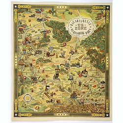
US ZONE. Bavaria, Hesse, Wurtemberg, Baden.
An unusual decorative pictorial map, from the years immediately following World War II, depicting the American Zone of Occupation in southern Germany. It portrays rural ...
- $450 / ≈ €396
Place & Date: Munich, 1940
![Map of the Occupied Areas. Carte des Zones d'Occupation. Der Besatzungs-Zonen mit Neuen Postleitgebieten. Karta Okkupacionnych Zon [in Cyrillic.]](/uploads/cache/42060-250x250.jpg)
Map of the Occupied Areas. Carte des Zones d'Occupation. Der Besatzungs-Zonen mit Neuen Postleitgebieten. Karta Okkupacionnych Zon [in Cyrillic.]
A poster map of Germany and Austria showing the Allied occupation zones as agreed at the Potsdam Conference after the end of the Second World War, with an inset detail of...
- $350 / ≈ €308
Place & Date: Frankfurt-am-Maine: Atlanta-Service, 1946