
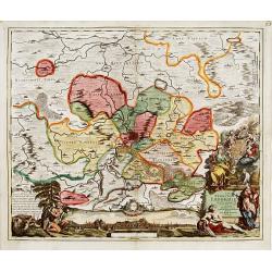
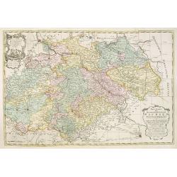
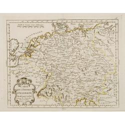
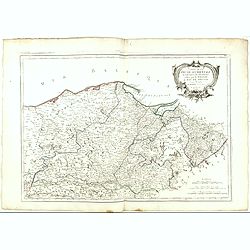
La Souabe meridionale, suivant les nouvelles observations..
Uncommon edition of this map of Southern Germany. With decorative title cartouche lower right corner.This example is unusual in having the additional separately engraved ...
- $90 / ≈ €79
Place & Date: Amsterdam 1728

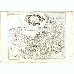
L'Archeveché de Mayence, suivant les nouvelles observations..
With decorative title cartouche lower left corner. Including river Rhine. This example is unusual in having the additional separately engraved decorative framework border...
- $100 / ≈ €88
Place & Date: Amsterdam, 1728

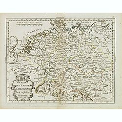
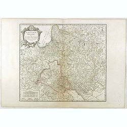
Landgraviat de Hesse, suivant les nouvelles observations..
With decorative title cartouche lower right corner.This example is unusual in having the additional separately engraved decorative framework border around the map, the re...
- $90 / ≈ €79
Place & Date: Amsterdam 1728

Nova et Accurata Ducatus Cliviae et Comitatus Marchiae.
With an elaborate -uncolored- title cartouche.
Place & Date: Augsburg, 1728

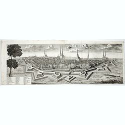
Heidelberg.
A spectacular panoramic view of Heidelberg, with legends numbered from 1-72 in German. With the title in a banderol.After a design by Friedrich Bernhard Werner (1690-1776...
- $1500 / ≈ €1321
Place & Date: Augsburg, 1729

Bamberg in Francken.
A spectacular panoramic view of Bamberg, with legends numbered from 1-24 in German. With the title in a banderol.After a design by Friedrich Bernhard Werner (1690-1776) w...
- $1500 / ≈ €1321
Place & Date: Augsburg, 1729

Ingolstadt.
A spectacular panoramic view of Ingolstadt in Bavaria, with legends numbered from A-P and 1-6 in German. With the title in a banderol.After a design by Friedrich Bernhard...
- $1500 / ≈ €1321
Place & Date: Augsburg, 1729

Hamburg.
A spectacular panoramic view of Hamburg, with legends numbered 1-19 and A-Z in German. With the title in a banderol.After a design by Friedrich Bernhard Werner (1690-1776...
- $2000 / ≈ €1761
Place & Date: Augsburg, 1729
Lübeck.
A spectacular panoramic view of Lübeck, with legends numbered 1-28 in German. With the title in a banderol.After a design by Friedrich Bernhard Werner (1690-1776) who wa...
- $1500 / ≈ €1321
Place & Date: Augsburg, 1729

Praefectura Lipsiencis. . .
Detailed map centered around Leipzig with large pictorial cartouche and smaller cartouche of explanations. Alphabetical list of place names down both sides.
- $150 / ≈ €132
Place & Date: Augsburg, 1730

Augusti. II. Re di Polonia, Ellettore di Sassonia.
Portrait of Augustus II the Strong (12 May 1670 – 1 February 1733) of the Albertine line of the House of Wettin was Elector of Saxony (as Frederick Augustus I), Imperia...
Place & Date: Venice, 1739
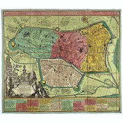
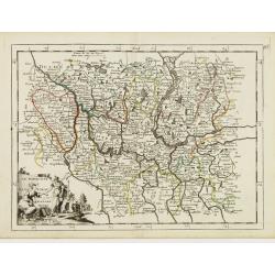
Nova Territorii Erfordien in suas praefecturas..
"Showing the area of Erfurt. In the lower part, there is a panoramic view of the town. Lower left and right splendid cartouches.The cartouches are painted in a stron...
- $300 / ≈ €264
Place & Date: Nurenberg, 1740

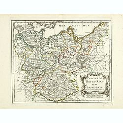
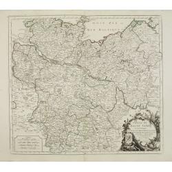
Circulus Saxoniae inferioris.
Detailed map of Saxen, including Bremen, Berlin, Lübeck, etc. Johann Baptist Homann (1663-1724) was a German engraver and publisher, who established himself and his fami...
- $200 / ≈ €176
Place & Date: Nuremberg 1740

Ducatus Magdeburgensis Et Halensis cum finitimis Delineatio geographica. . .
Very decorative map centered on Magdeburg with Elbe river. With a key to the left and right of the map.
- $75 / ≈ €66
Place & Date: Augsburg, ca. 1740

Delineatio geographica praefecturarum Wittebergensis et Graefenhaynichen; in circulo electorali sitarum. . .
Very decorative map of Mansfeld Land, a region in the southwestern corner of the German state of Saxony-Anhalt. The region derives its name from the counts of Mansfeld, w...
- $75 / ≈ €66
Place & Date: Augsburg, ca. 1740

Delineatio geographica praefecturarum Wittebergensis, et Graefenhaynichen. . .
Showing Amt Wittenberge with the river Elbe. Wittenberge is a town of eighteen thousand people on the middle Elbe in the district of Prignitz, Brandenburg.
- $75 / ≈ €66
Place & Date: Augsburg, 1740

Delineatio Geographica Ditionis Martisburgensis hodie regiis et electoralibus auspiciis florentis edita. . .
Map shows the surrounding of the city of Halle. With a very large title cartouche occupying the lower left corner. Engraved by Tobias Conrad Lotter.
- $75 / ≈ €66
Place & Date: Augsburg, 1740

Praefecturae Principatus Querfurtensis Dahmiana et Iüterboccensis cum vicinia oppidis, vicis, pagis accurate distincta. . .
Showing the region of Ämter Dahme, Jüterbog, Baruth. With in the north Potsdam and in the south Schönwalde, in the west Brück/ Zahna and in the east Buchholz/ Luckau.
- $50 / ≈ €44
Place & Date: Augsburg, ca. 1740
Accurata recens delineata ichnographia celeberrimæ liberæ Imperii civitatis ac Sueviæ metropolis Agustæ Vindelicorum -Neu verfertigt accurater ... Haupt Stadt Augspurg.
Superb plan of the fortified town of Augsburg, brilliantly colored at the time, with title in Latin and German. The plan was designed by Johann Thomas Kraus, engraver, ar...
- $1200 / ≈ €1057
Place & Date: Nuremberg, ca. 1740
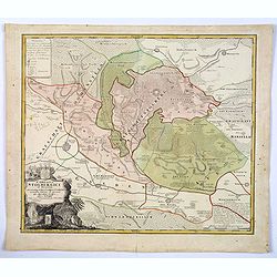
Comitatus Stolbergici ad Hercyniam. . .
The County of Stolberg (Grafschaft Stolberg) was a county of the Holy Roman Empire located in the Harz mountain range in present-day Saxony-Anhalt, Germany. It was ruled ...
- $100 / ≈ €88
Place & Date: Nuremberg, ca 1740

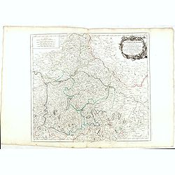
Cours du Danube, Feuille 1 contenant LA SUABE . . .
Fine map of part of the River Danube, including the southern German province of Swaben.From his rare atlas "Theatre de la Guerre en Allemagne, contenant toutes les O...
Place & Date: Paris, 1744

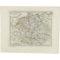
Nieuwe Kaart van de Frankische en Zwabische Kreits.
Deatailed map of the Southern part of Germany. Isaak Tirion was born in Utrecht ca. 1705. He came to Amsterdam ca. 1725. Tirion published a number of important books, m...
- $100 / ≈ €88
Place & Date: Amsterdam, 1745
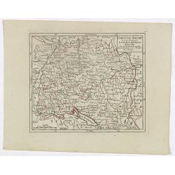
![Partie Septentrionale de la Souabe [and] Partie Meridionale de la Souabe. (2 maps)](/uploads/cache/21468-250x250.jpg)
Partie Septentrionale de la Souabe [and] Partie Meridionale de la Souabe. (2 maps)
Pair of maps forms a large, detailed view of Swabia, one of the ten circles of the Holy Roman Empire and containing some of the historically most interesting and cultural...
- $250 / ≈ €220
Place & Date: Amsterdam c. 1745

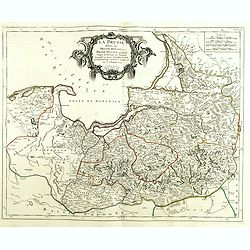
Corbeiensis Dioecesis pro ut nunc est, descriptio noua Authore Joanne Gigante D. Medico et Mathemat.
Rare map of eastern part of Germany. West to the top. Showing the river Weser. Prepared by Johann Michael Gigas (1582-1637).
- $200 / ≈ €176
Place & Date: Venice, 1746

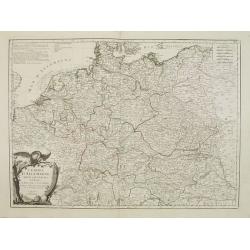
Nieuwe Kaart van Duitsland..
Detailed map of Germany, including The Netherlands, Belgium, Luxembourg, Switzerland and Austria. Isaac Tirion was born in Utrecht ca. 1705. He came to Amsterdam ca. 1725...
- $120 / ≈ €106
Place & Date: Amsterdam, 1747
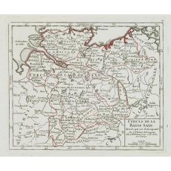
Cercle de la Basse Saxe, divisée par ses Principautés.
Small detailed map of the northern part of Germany. From Atlas Portatif Universel, by Robert de Vaugondy.Unrecorded state with erased date. Page 22 outside border top rig...
- $50 / ≈ €44
Place & Date: Paris, later than 1749

Partie Sept.le du Cercle de la Haute Saxe divisé par ses Principautés.
Small detailed map of the northeastern part of Germany, with Berlin at the bottom. Including part of Poland. From Atlas Portatif Universel, by Robert de Vaugondy.Unrecord...
- $75 / ≈ €66
Place & Date: Paris, later than 1749

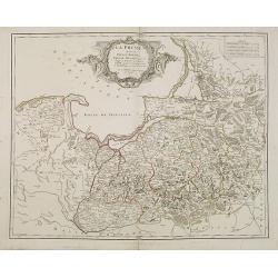
La Prusse divisée en Prusse royale, et Prusse Ducale. . .
Finely and crisply engraved map of Prussia including The Bay of Danzig. Ornamental title cartouche in the upper part of the map from his "Atlas Universel".Gille...
- $300 / ≈ €264
Place & Date: Paris, 1750

Principatus Halberstadiensis, abbat : Quedlinburgens cum Comitatu Wernigerodano, ad hodiernum verum statum ex acta prodiit ex officina geogr. . .
Detailed map showing principality Halberstadt, Abtei Quedlinburg and the county Wernigerode. Including the towns of Osterwieck, Stollberg, Aschersleben and Oschersleben.
Place & Date: Augsburg, 1750

Electoratus saxonici praefecturae annaburgensis pretzschens torgaviensis schweinicensis. . .
Highly detailed map showing the regions of Annaburg, Pretzsch, Schweinitz in Sachsen-Anhalt, Torgau in Sachen and Mühlberg an der Elbe in Brandenburg. In the center of t...
- $60 / ≈ €53
Place & Date: Augsburg, 1750
La Prusse divisée en Prusse Royale et Prusse Ducale. . .
Finely and crisply engraved map of Prussia including The Bay of Danzig. Folio map by Giles Didier Robert De Vaugondy.Ornamental title cartouche in the upper part of the m...
- $350 / ≈ €308
Place & Date: Paris, 1751

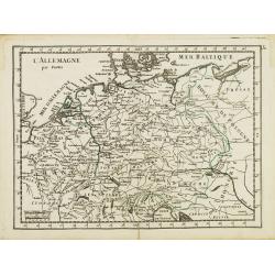
L'Allemagne.
Scarce small map of Germany, Poland and Low Countries based on cartography of Guillaume Delisle (. Published in "Nouveau traité de geographie par M**** ", publ...
- $50 / ≈ €44
Place & Date: Paris, 1752

Cercle de Franconie . . .
Finely and crisply engraved map of part of Germany. Map by Giles Didier Robert De Vaugondy with erased title cartouche. Ornamental title cartouche in the upper part of ma...
- $50 / ≈ €44
Place & Date: Paris, 1752
L' Allemagne par Postes.
Fine map of Germany. George Louis Le Rouge was active from 1740 to 1780 as a publisher and was appointed engineer for the King of France. From his "Atlas Nouveau Por...
- $60 / ≈ €53
Place & Date: Paris 1756
Le Marquisat et Electorat de Branderbourg.
Fine map of Brandenburg, with decorative title cartouche. George Louis Le Rouge was active from 1740- till 1780 as a publisher, and was appointed engineer for the King of...
- $30 / ≈ €26
Place & Date: Paris 1756

Cercle de Basse Saxe.
Fine map of Lower Saxony, with decorative title cartouche. With manuscript notes in left and right margins giving some historical information about the region. George Lou...
- $50 / ≈ €44
Place & Date: Paris, 1756

Cercle de Westphalie.
Fine map of North Rhine-Westphalia. George Louis Le Rouge was active from 1740 till 1780 as a publisher, and was appointed engineer for the King of France. From his Atlas...
- $30 / ≈ €26
Place & Date: Paris 1756

Germania Antiqua. . .
A fine map of ancient Germany, Poland and the Netherlands from his "Atlas Universel".Gilles Robert de Vaugondy (1688–1766), also known as Le Sieur or Monsieur...
- $50 / ≈ €44
Place & Date: Paris, 1756
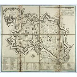
Plan de Hanover.
Town-plan of Hanover, with the new town of St Aegidien built in 1747. Decorated with a title cartouche and accompanied by a numbered key (1-79) of the main streets and bu...
- $200 / ≈ €176
Place & Date: Paris, 1757
Neue Karte des Kuhrfürstenthums Sachsen. . .
Scarce road map, first published by Peter Schenk II (1698-1775) in his "Neuen Sächsischen Atlas". It is based on a map already created and 1732 and improved in...
- $750 / ≈ €660
Place & Date: Amsterdam, 1758
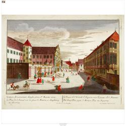
Der Zeug=Platz gegen S.Morizen Plaz zu Augspurg.
A well-known publisher of optical prints, established in Augsburg.In the eighteenth and nineteenth centuries there were many popular speciality establishments in Paris, A...
- $200 / ≈ €176
Place & Date: Augsburg, 1760
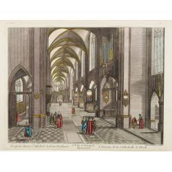
13e. Vüe d'Optique Representant L'Interieur de la Cathedralle de Dorth.
Optical view representing the interior of a Cathedral in Dörth, near Wiesbaden. Published by Daumont, a well-known publisher of optical prints, established in Paris.In t...
- $200 / ≈ €176
Place & Date: Paris, 1760
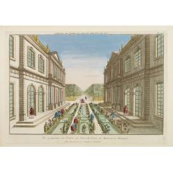
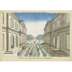
Vue perspective de l'Entrée du Parc du Prince de Manheim en Allemagne.
Perspective view of the Royal Park in Manheim by Basset, a well-known publisher of optical prints, established in rue St.Jacques in Paris. With brief key list.In the eigh...
- $200 / ≈ €176
Place & Date: Paris, 1760
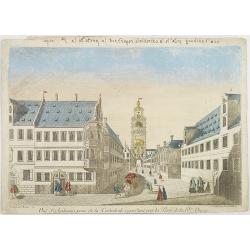
Vue perspective de la Ville et Forteresse Electorale de Koningstein, et de la Montagne de Lilienstein avec ses environs du côté du Couchant, dépendant des Etats de Saxe, appartenant à Sa Majesté le Roy de Pologne.
Perspective view of Königstein fortress, situated near to Dresden in Saxony. To the left the Fortress and in the foreground the river Elbe. The castle was inhabited by A...
Place & Date: Paris, 1760

Vüe de Morestburg en Saxe, l'une des Maisons de Chasse du Roy de Pologne. (Castle Moritzburg)
So-called optical print illustrating a perspective view of the Castle Moritzburg, a Baroque Germanic castle in the small town of Moritzburg in the German state of Saxony....
- $250 / ≈ €220
Place & Date: Paris, 1760

A view of BILNITZ in Saxony one of the palaces of the King of Poland. / Vüe de Bilnitz, en Saxe, un des Palais du Roi de Pologne.
So-called optical print illustrating a perspective view of Pillnitz Castle, a restored Baroque castle at the eastern end of the city of Dresden. The castle was once the s...
- $300 / ≈ €264
Place & Date: Paris, 1760
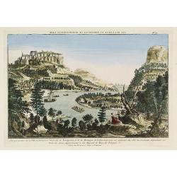
Vue de la Fontaine des Eaux chaudes et de la place d'Aix la Chapelle.
So-called optical print illustrating a perspective view of Aachen, in Nordrhein Westphalia, and namely the Elisa Fountain which contains two fountains with thermal water....
- $250 / ≈ €220
Place & Date: Paris, 1760
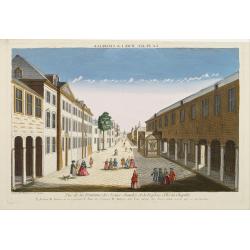
Vue d'Ausbourg prise de la Cathedrale regardant vers la Porte de la Sainte Vierge.
Charming view of the Cathedral (Dom St. Maria) in Augsburg. In top of the print the title, in mirror image, in manuscript. Published by André Basset, the younger engrave...
- $100 / ≈ €88
Place & Date: Paris, ca 1760
Entree du parc du Prince à Manheim.
Perspective view of the Royal Park in Manheim by Basset, a well-known publisher of optical prints, established in rue St.Jacques in Paris. With a brief key list.In the ei...
- $75 / ≈ €66
Place & Date: Paris, 1760
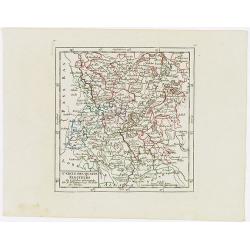
![Partie septentrionale du cercle de Haute Saxe [...] Brandebourg.](/uploads/cache/33211-250x250.jpg)
Partie septentrionale du cercle de Haute Saxe [...] Brandebourg.
Finely and crisply engraved map of north eastern part of Germany, including part of Poland. With inset map of Brandenburg. Map by Giles Didier Robert De Vaugondy with era...
- $150 / ≈ €132
Place & Date: Paris, c. 1760

Empire of Germany.
Uncommon miniature map of Germany, Poland, the Low Countries and Eastern Europe, engraved by Thomas Kitching for "A New General and Universal Atlas Containing Forty ...
- $40 / ≈ €35
Place & Date: London, 1761-1763
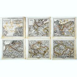
The Empire of Germany.
Uncommon miniature map in six sheets of the Empire of Germany, engraved by Thomas Kitching for "A New General and Universal Atlas Containing Forty five Maps by Andre...
- $75 / ≈ €66
Place & Date: London, 1761-1763
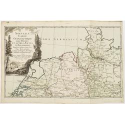
Nouvelle carte géographique des postes et autres routes d'Allemagne. . .
Map showing the northern provinces in Germany and part of the Netherlands. Decorative title cartouche in the upper left corner. A so-called post road maps.
- $80 / ≈ €70
Place & Date: Paris, 1766

Bataille du Johansberg Gagnée par son Altesse Sérénissime Monseigneur le Prince de Condé . . . Le 30 Aoust 1762 . . .
Five detailed military battle-plans showing the four stages in the siege of Johansburg and the battle plan around Grüningen published by Jean de Beaurain (1696–1771) ....
- $150 / ≈ €132
Place & Date: Paris, 1766
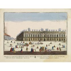
(Berlin) Prospectus Armamentarii regnii versus arcem principis regis haereditarii Berolini.
A square in Berlin. In the eighteenth and nineteenth centuries there were many popular speciality establishments in Paris, Augsburg and London which produced optical view...
- $200 / ≈ €176
Place & Date: Italy, 1770
Cercles de Haute-Saxe et de Basse-Saxe.
Early edition of this fine map of the duchies of Saxony (upper & lower), including part of present-day Poland. Published in "Atlas Portatif de Vaugondy".Cha...
- $75 / ≈ €66
Place & Date: Paris, ca.1770
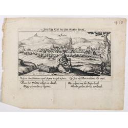
Sontra.
A panoramic view of the city Sontra in Hessen . With motto "ein klug Kind das sein Mutter kennt". On the foreground, a woman with two children and a crypt. With...
- $50 / ≈ €44
Place & Date: Frankfurt, 1623-1778

La Germania divisa ne' suoi differenti stati
Rare map of Germany, from "Atlante Novissimo ad uso Dei Giovani Studiosi Contenuto In Carte XXVII.", published by Giovanni Zempel in Rome, ca. 1780.The map is b...
- $25 / ≈ €22
Place & Date: Rome, 1780
Carte de l'Empire d'Allemagne Divisé par Cercles..
Rare map of Germany and the Low Countries prepared by J.B.Nolin and published by Monhare for his Atlas Général a l'usage des colleges et maisons d'education.Louis Josep...
- $100 / ≈ €88
Place & Date: Paris, 1783

Carte de L'Empire D'Alemagne avec les Etats de Bohême..
Attractive map centered on the southwestern part of Germany, including Switzerland, Luxembourg and part of Austria.Decorative title cartouche with wine grapes, musical in...
- $75 / ≈ €66
Place & Date: Paris ca 1783
Carte de l'Empire d' Allemagne . . .
Scarce map of Germany prepared by de la Fosse and published by L.J. Mondhare for his Atlas Général a l'usage des colleges et maisons d'education.. Louis Joseph Mondhare...
- $50 / ≈ €44
Place & Date: Paris, 1783

Cercle de Haute Saxe.
Finely and crisply engraved map of Germany, centered on Leipzig .Venetian edition of Giles Didier Robert De Vaugondy's map from Atlas Universel printed in 1776-84.Ornamen...
- $150 / ≈ €132
Place & Date: Venice, 1776 - 1784
Cercle de Basse Saxe où sont distingués les états de ... et des évêchés d'Hildesheim et d'Halberstadt par le Sr. Robert.
Finely and crisply engraved map of northern part of Germany, including the river Elbe, with Hamburg until Potsdam. In the upper right the Baltic coast including Wismar, R...
- $150 / ≈ €132
Place & Date: Venice, 1776 - 1784
L'Empire d'Allemagne..
Detailed map encompassing Germany, the Netherlands, Belgium, Austria, and part of Poland.Venetian edition of the map by Bellin, to whom Santini gives credit in the cartou...
- $100 / ≈ €88
Place & Date: Venice, 1776 - 1784
La Prusse divisée en Prusse Royale et Prusse Ducale.
The map extends from Memem, Danzig and Rosienne in the North to Novigrod in the southeast and Thorn on the Wessel in the southwest. Shows the Gulf of Danzig and part of P...
- $300 / ≈ €264
Place & Date: Venice, 1776 - 1784

Carte des Cercle du Haut et du Bas Rhin.. avec leurs enclaves.
Finely and crisply engraved map of Germany showing the river Rhine, including Duisburg, Spire, Mannheim, etc.With ornamental title cartouche and noteworthy topographical ...
- $75 / ≈ €66
Place & Date: Venice, 1776 - 1784

Cercle de Franconie.. Reineck d' Erpach.
Finely and crisply engraved map, centered on Schweinfurt, Bamberg and Nuremberg.With ornamental title cartouche and noteworthy topographical detail.The map was prepared b...
- $100 / ≈ €88
Place & Date: Venice, 1776 - 1784
Le cercle De Baviere.. et la prevoté de Berchtolsgaden.
Finely and crisply engraved map centered on Regensburg, including some great skiing resort areas of Austria and part of Germany, centered on Passau, Ingollstat, Salzburg....
- $100 / ≈ €88
Place & Date: Venice, 1776 - 1784

Cercle de Haute Saxe.
Finely and crisply engraved map of Germany, centered on Leipzig. From Atlas Universel printed in 1776-84.With ornamental title cartouche and noteworthy topographical deta...
- $75 / ≈ €66
Place & Date: Venice, 1776 - 1784

Cercle de Basse Saxe où sont distingués les états de ... et des évêchés d'Hildesheim et d'Halberstadt par le Sr. Robert.
Finely and crisply engraved map of northern part of Germany, including the river Elbe, with Hamburg until Potsdam. In the upper right the Baltic coast including Wismar, R...
- $100 / ≈ €88
Place & Date: Venice, 1776 - 1784

Cercle de Westphalie divisé en tous ses Etats et Souverainetés.
Finely and crisply engraved map of central Germany, including the river Rhine from Deventer till Bonn, with Dusseldorf. In upper left , inset of the area of Emden until O...
- $100 / ≈ €88
Place & Date: Venice, 1776 - 1784
La Prusse divisée en Prusse Royale et Prusse Ducale.
The map extends from Memem, Danzig and Rosienne in the North to Novigrod in the southeast and Thorn on the Wessel in the southwest. Shows the Gulf of Danzig and part of P...
- $200 / ≈ €176
Place & Date: Venice, 1776 - 1784
Carte De La Prusse Occidentale ou sont tracees les Provinces cedees Par la Pologne au Roi De Prusse . . . 1775
Finely and crisply engraved map of Western Prussia, now part of Poland on the Baltic Sea, including the Bay of Danzig. With ornamental title cartouche and noteworthy topo...
- $250 / ≈ €220
Place & Date: Venice, 1776 - 1784

L'Allemagne dressée sur les observations. . .
Map of Germany, Low Countries, Poland, Switzerland, Northern Italy. Prepared by G.De L'Isle after observations by Kepler and Tycho Brahe.Engraved by Jean Batiste Liébaux...
- $300 / ≈ €264
Place & Date: Paris, 1788
Le Royaume De Pologne, divise selon les Partages faits en 1772, 1793 et 1795, etnre la Russie, la Prusse et l'Autriche . . .
The uncommon later edition of this detailed map of Poland, showing the lands lost to Russia, Prussia and Austria in 1772, 1793 and 1795. with a color key added underneath...
- $600 / ≈ €528
Place & Date: Paris, ca. 1796
Empire d'Allemagne divisé par Cercles et Cours du Rhin.
Small detailed map of Germany, the Low Countries, Switzerland, Austria, Czechoslovakia and part of Poland.From Atlas Portatif Universel, by Robert de Vaugondy. Edited by ...
- $40 / ≈ €35
Place & Date: Paris, 1799

Cercle de Westphalie, divisé suivant ses différentes Principautés.
Small detailed map of the north western part of Germany, centred on Münster. From Atlas Portatif Universel, by Robert de Vaugondy.Edited by : "Au dépôt de Géogra...
- $30 / ≈ €26
Place & Date: Paris, 1799
Cercle de Souabe où sont distingués les Enclaves de la Maison d'Autriche.
Small detailed map showing the state Baden-Württemberg, part of Bavaria and part of Austria.From Atlas Portatif Universel, by Robert de Vaugondy. Edited by : "Au d�...
- $70 / ≈ €62
Place & Date: Paris, 1799

VII. Cours du Rhin où sont les environs de Philisbourg, Spire Landaw &c.
Small detailed map illustrating the stretch of the Rhine which flows between Germersheim and Speyer.From Atlas Portatif Universel, by Robert de Vaugondy. Edited by : &quo...
- $25 / ≈ €22
Place & Date: Paris, 1799
Cercle des quatre Electeurs.
Small detailed map of part of western Germany, centered on Frankfurt. From Atlas Portatif Universel, by Robert de Vaugondy.Edited by : "Au dépôt de Géographie, Ru...
- $25 / ≈ €22
Place & Date: Paris, 1799