Browse Listings in Europe > France > France Provinces
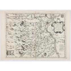
Contado DE Venassino, E prencipato d'Oranges . . .
A most attractive and decorative map centered on Avignon and Orange, by Vincenzo Coronelli. An elaborate title cartouche garlanded with intertwined flowers and dedicated ...
- $400 / ≈ €352
Place & Date: Venise 1690
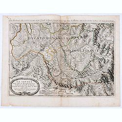
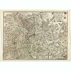
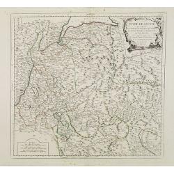
La Savoia divisa nelle sue Principali Provincie da Giacomo Cantelli da Vignola . . .
Late 17th century maps of the Savoy region, based on the reports of Giacomo Cantelli da Vignola and published in Roma in Giacomo de Rossi's world atlas Mercurio Geografic...
- $250 / ≈ €220
Place & Date: Rome, 1692

Disegno Idrografico del Canale Reale . . .
A decorative Coronelli map showing the Canal du Midi. It shows the extent of the canal from the Mediterranean sea at Narbonne to Toulouse. Featuring a pair of large coats...
- $300 / ≈ €264
Place & Date: Venice, 1695-1697

Plan d'un marais salant . . .
Aerial view of a salt marsh, with depiction of working scenes and a nice cartouche, from Nicolas de Fer's "L'Atlas curieux ou le Monde réprésente dans des cartes. ...
Place & Date: Paris, 1705

Gouvernement general de Languedoc . . .
Map of the Languedoc region, from Nicolas de Fer's "L'Atlas curieux ou le Monde réprésente dans des cartes. "The "Atlas Curieux" is a geographic enc...
Place & Date: Paris, 1705

Souveraineté de Neuchatel et de Vallangin.
Map of the Neuchatel region, from Nicolas de Fer's "L'Atlas curieux ou le Monde réprésente dans des cartes. "The "Atlas Curieux" is a geographic enc...
Place & Date: Paris, 1705

Les Provinces, ou Gouvernement de Poictou, d'Anjou, du Maine, De Touraine . . .
Map centered on Loire region, with Blois, Saumur, Sancerre and Orleans, from Nicolas de Fer's "L'Atlas curieux ou le Monde réprésente dans des cartes. "The &q...
Place & Date: Paris, 1705
Gouvernement general du Lionnois, generalitez de Lion et de Riom . . .
Map of central France with Clermont-Ferrand and Lyon to the right, from Nicolas de Fer's "L'Atlas curieux ou le Monde réprésente dans des cartes. "The "A...
Place & Date: Paris, 1705
Gouvernement de Dauphiné, Generalité de Grenoble.
Map of the Dauphiné region, from Nicolas de Fer's "L'Atlas curieux ou le Monde réprésente dans des cartes. "The "Atlas Curieux" is a geographic enc...
Place & Date: Paris, 1705

Gouvernement general de Picardie . . .
Map of the Picardie region, from Nicolas de Fer's "L'Atlas curieux ou le Monde réprésente dans des cartes. "The "Atlas Curieux" is a geographic ency...
Place & Date: Paris, 1705
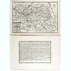
Les Gouvernements generaux de l'Isle de France et de Champagne, ou se trouvent les generalitez de Paris et Chaalons.
Map of the Isle de France and Champagne regions, from Nicolas de Fer's "L'Atlas curieux ou le Monde réprésente dans des cartes. "The "Atlas Curieux"...
Place & Date: Paris, 1705
Le Païs Messin, ses dependances, et Terre Adiacentes.
Map of the Messin region, from Nicolas de Fer's "L'Atlas curieux ou le Monde réprésente dans des cartes. "The "Atlas Curieux" is a geographic encycl...
Place & Date: Paris, 1705

(Clermont, Brioude, Le Puy, etc.)
Rare miniature map including the towns of Clermont, Brioude, Le Puy, etc. From "Le theatre De Bellone, Contenant 48. nouvelles Cartes Geographiques, Des Païs-Bas Es...
- $60 / ≈ €53
Place & Date: Amsterdam, 1710
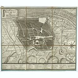
Plan de la ville de Treves.
Very rare town-plan of Trier by Didier Bugnon (1676-1736), geographer of the Duke of Lorraine. With numbered key (1-57) of the main buildings and buildings of the city. T...
Place & Date: Paris?, 1720

Carte Historique et Geographique pour Introduire a l' Intelligence de l'Histoire de Savoye . . .
Folio sheet with an attractive map of the border region of France, Switzerland and Italy. An inset map of the fortification of Torino and the Palace of Venerie. Cartouche...
- $30 / ≈ €26
Place & Date: Amsterdam, 1728

Carte Pour L'Intelligence De L'Histoire De Lorraine . . .
Map of Lorraine, surrounded by 34 portraits of the rulers of Lorraine and information concerning the present government structure of the Duchy. Surmounted by an elaborate...
- $50 / ≈ €44
Place & Date: Amsterdam, 1728
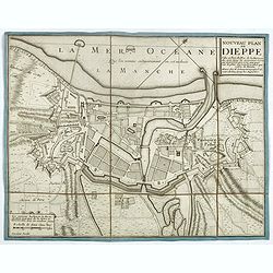
Nouveau plan de Dieppe, ville et port de mer de la Normandie.
Beautiful plan showing the fortified town of Dieppe and the suburbs of Barre and Pollet, engraved by Inselin. Beautiful example.
- $230 / ≈ €203
Place & Date: Paris, ca. 1730

Nova et accurata Normandiae Ducatus Tabula . . .
This very rare map of Britany made by the Amsterdam publisher and Pieter Persoy (1675-1695). This among fourteen other maps are sometimes found in atlases by Frederik de ...
Place & Date: Amsterdam, 1730

Theatre de la Guerre en Savoie et en Piémont - Le Dauphiné, La Bresse - Partie du Lionnois et de la Provence./ Theatre de la guerre en Dauphiné et en Provence…
Rare wall map of the Savoie/Piémont and Dauphiné/Provence region. Decorated with 2 title-cartouches, one at upper right part (Savoye/Piémont) and one at lower right pr...
- $3000 / ≈ €2641
Place & Date: Amsterdam, c.1735
![[Lot of 5 maps of the mouth of the Gironde river] Carte des Entrees et Cours de la Gironde](/uploads/cache/86010-250x250.jpg)
[Lot of 5 maps of the mouth of the Gironde river] Carte des Entrees et Cours de la Gironde
A large sea chart of the mouth and course of the Gironde river as far inland as Bordeaux. Decorated with three cartouches.Jacques Nicolas Bellin (1702-720) was the most i...
- $350 / ≈ €308
Place & Date: Paris, c. 1740

Carte des Pais Bas contenant la Flandre, le Brabant, Pais de Liege. . .
Map sheet from a multi-sheet map of the Low Countries, showing a large title cartouche and part of the Northern French coast line around Calais, Duinkerken and Furnes. Th...
- $75 / ≈ €66
Place & Date: Paris, 1742

Plan du Golfe et des Caps de St. Tropez. par Jacques Ayrouard . . .
Large plan of the harbour St. Tropez. Decorated with a large compass rose.From the rare chart book by Jacques Ayrouard: "Recueil de plusieurs plans des ports et rade...
- $275 / ≈ €242
Place & Date: Marseille, 1732-1746

A Map of the Rout which Hannibal took through Gaul & over the Alpes into Italy.
A map showing the (clear) route the North African, Carthaginian General Hannibal took to get from Spain to northern Italy, via France and the Alps. Ancient, Latin names a...
- $40 / ≈ €35
Place & Date: London, 1747

III. Carte du C.té de Haynaut et des Frontieres du C.té de Flandre..
Attractive small map encompassing part of the Nord, between Douai and Valenciennes.From Atlas Portatif Universel, by Robert de Vaugondy.Unrecorded state with erased date....
- $50 / ≈ €44
Place & Date: Paris, after 1748

Tabula Geographica Campaniae. . .
Map of the Champagne region with Rheims, Châlons, Vitry in the center. In upper left corner two inset views with the towns of Reims et Troyes.
- $225 / ≈ €198
Place & Date: Nuremberg, ca. 1750

Carte particuliere des costes de Poittou, Aunis et de la Rochelle.
Finely designed and rare map of Isle Ré and the French coast with La Rochelle.
- $1250 / ≈ €1101
Place & Date: Amsterdam, c. 1750

L'Isle de Ré.
Fine map of the French island called Île de Ré. George Louis Le Rouge was active from 1740- till 1780 as a publisher, and was appointed engineer for the King of France....
- $175 / ≈ €154
Place & Date: Paris, 1756
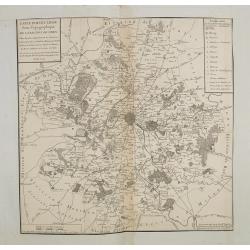
Carte particuliere semi-topographique de l'election de Paris. . .
Very decorative maps. Maps of the Parisian region. Map including Luzarches, Orgeval, Arpajon, Bussy saint georges.
- $300 / ≈ €264
Place & Date: Paris 1779
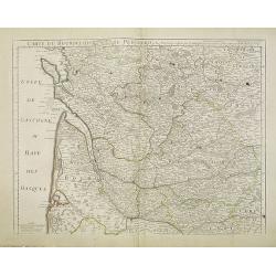
Carte du Bourdelois du Perigord et des provinces voisines..
Map covering the area from La Rochelle till the surrounding country of Bordeaux to the south and till Limoges and Cahors to the east.
- $120 / ≈ €106
Place & Date: Paris, c. 1780
Duché de Savoye qui comprend..
Finely and crisply engraved map of Savoy. Venetian edition of de Vaugondy's map, from "Atlas Universel" printed in 1776-84.Large decorative title cartouche in t...
- $150 / ≈ €132
Place & Date: Venice, 1776 - 1784

Gouvernements de Flandre Françoise, d'Artois, de Picardie. . .
Detailed map encompassing northwestern part of France, with the Channel and tip of southern England. With ornamental title cartouche and noteworthy topographical detail.T...
- $100 / ≈ €88
Place & Date: Venice, 1776 - 1784

Gouvernement de l'Isle de France et de celui de l'Orléanois. . .
Detailed map encompassing present day north of France.Venetian edition of the map by Bellin, to whom Santini gives credit in the cartouche.From "Atlas Universel"...
- $100 / ≈ €88
Place & Date: Venice, 1776 - 1784

Gouvernements de Champagne et Brie.
Detailed map encompassing Champagne and Brie.Venetian edition of the map by Bonne, to whom Santini gives credit in the cartouche.From "Atlas Universel" publishe...
- $75 / ≈ €66
Place & Date: Venice, 1776 - 1784

Gouvernements de Lorraine et d'Alsace.
Detailed map encompassing present day the east of France.Venetian edition of the map by Bonne, to whom Santini gives credit in the cartouche.From "Atlas Universel&qu...
- $100 / ≈ €88
Place & Date: Venice, 1776 - 1784

Gouvernements de Berri, du Nivernois,de la Marche, Limousin..
Detailed map encompassing Berri, Nivernois, Limousin and Auvergne.Venetian edition of the map by Bonne, to whom Santini gives credit in the cartouche.From "Atlas Uni...
- $75 / ≈ €66
Place & Date: Venice, 1776 - 1784
Plan de St. Jean de Luz avec les différents projets d'agrandissem.t du port.
Very rare and beautiful plan of the city and bay of Saint-Jean-de-Luz, detailing the projects of expansion of the port undertaken in 1780.The plan indicates the Artha Roc...
- $2200 / ≈ €1937
Place & Date: Paris, 1784

Gouvernements de Bourgogne, de Franche Comté et de Lyonnois.
Detailed map encompassing Bourgogne, Franche Comté and Lyonnois.Venetian edition of the map by Bonne, to whom Santini gives credit in the cartouche.From "Atlas Univ...
- $100 / ≈ €88
Place & Date: Venice, 1776 - 1784

Carte de la Marche, du Bourbonnois, de Limousin, et de l'Auvergne.
Very fine map of Auvergne, Limousin, Bourbonnois and Marche regions in France. Engraved by Ballet and included in the rare atlas "Atlas Universelle" by Philippe...
- $150 / ≈ €132
Place & Date: Paris, 1787
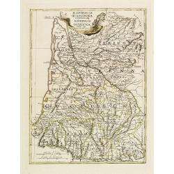
Il Governo di Guascogna con porzione del Governo di Guienna.
Rare regional map of France of the Périgord, Guienne, Gascogne and the Béarn published by Carli Pazzini in Siena.
Place & Date: Siena, 1792

Les environs de Mons, Beaumont, Chimay, Valenciennes, Condé, &c.
Detailed map of Northern France, centered on Valenciennes and Mons. The map was prepared by Jean Baptiste de Bouge (1757-1833), who prepared one of the first very detaile...
- $50 / ≈ €44
Place & Date: Bruxelles 1789 - 1793

VIII. Carte du C.té de Haynaut où sont les environs de Landrechies..
Attractive small map showing an area straddling the regions Picardy and Nord. It shows the towns of La Capelle, Landrecies and Avesnes-sur-Helpe.From Atlas Portatif Unive...
- $30 / ≈ €26
Place & Date: Paris, 1799

Theodorus Primus Corsicae Rex.
Portrait of Everard Jabach, three-quarter length, standing by the fragment of a column, facing left, wearing a cloak and doublet with plain collar, his left arm held behi...
- $40 / ≈ €35
Place & Date: Paris, 1652 - 1800
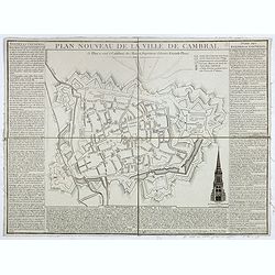
Plan nouveau de la ville de Cambrai.
Nice town-plan of Cambrai, with its fortifications and the citadel, decorated with the cathedral in lower right corner. The borders contain a historical description of th...
Place & Date: Cambrai, 1814

Tableau d'assemblage de la carte des environs de Versailles dite chasses impériales.
Key sheet to the rare 12 sheet map "Carte topographique des environs de Versailles dite des Chasses Impériales, levée et dressée de 1764 à 1773 par les ingénieu...
Place & Date: Paris, ca. 1820

Carte des environs de Pau. . .
Folding map of Pau and its surroundings, being a reduced version of the map by Comte Dulong de Rosnay and engraved by Nicolas Delamare and published by Lafon.More about f...
- $75 / ≈ €66
Place & Date: Pau, Lafon, 1840-1850

Dépt. De La Haute Loire. N°42.
Map of the Upper Loire region in France.Lovely map from one of the last decorative atlases of the nineteenth century.The rather simple map is framed by medallion portrait...
- $50 / ≈ €44
Place & Date: Paris, A. Combette, 1852
![Dépt. du Morbihan. N°. 55. [ Morbihan, Belle-Ile ]](/uploads/cache/43041-250x250.jpg)
Dépt. du Morbihan. N°. 55. [ Morbihan, Belle-Ile ]
Map of the Morbihan region in Brittany. Including "Belle-Ile".Lovely map from one of the last decorative atlases of the nineteenth century.The rather simple map...
Place & Date: Paris, A. Combette, 1852

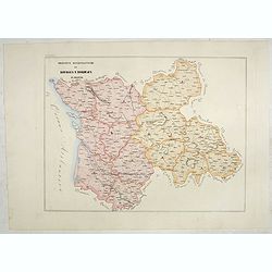
Province ecclesiastiche di Parigi, Rouen, Rheims, E Cambray in Francia (Tav LIV)
This large-format Paris, Rouen, Reims and Cambray map is finely engraved and beautifully colored and was prepared by Girolamo Petri, a lawyer who served as a senior offic...
- $300 / ≈ €264
Place & Date: Rome, 1858
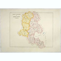
Province ecclesiastiche di Lione e Sens in Francia (Tav LV)
This large-format Lion and Sens map is finely engraved and beautifully colored and was prepared by Girolamo Petri, a lawyer who served as a senior official within the Vat...
- $300 / ≈ €264
Place & Date: Rome, 1858

Province ecclesiastica di Besançon in Francia (Tav LVI)
This large-format Besançon map is finely engraved and beautifully colored and was prepared by Girolamo Petri, a lawyer who served as a senior official within the Vatican...
- $300 / ≈ €264
Place & Date: Rome, 1858
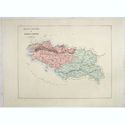
Province ecclesiastica di Tours e Rennes in Francia (Tav LVII)
This large-format Tours and Rennes map is finely engraved and beautifully colored and was prepared by Girolamo Petri, a lawyer who served as a senior official within the ...
- $300 / ≈ €264
Place & Date: Rome, 1858
Province ecclesiastiche di Bourges e Bordeaux in Francia (Tav LVIII)
This large-format Bourges and Bordeaux map is finely engraved and beautifully colored and was prepared by Girolamo Petri, a lawyer who served as a senior official within ...
- $300 / ≈ €264
Place & Date: Rome, 1858

Province ecclesiastiche di Albi, Auche e Toulouse in Francia (Tav LIX)
This large-format Albi, Auch and Toulouse map is finely engraved and beautifully colored and was prepared by Girolamo Petri, a lawyer who served as a senior official with...
- $300 / ≈ €264
Place & Date: Rome, 1858
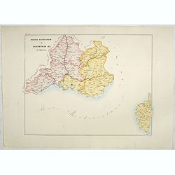
Province ecclesiastiche di Avignone ed Aix in Francia (Tav LX)
This large-format Avignon and Aix map is finely engraved and beautifully colored and was prepared by Girolamo Petri, a lawyer who served as a senior official within the V...
- $300 / ≈ €264
Place & Date: Rome, 1858
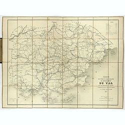
Carte routière et administrative du département du Var dressée sous l'administration et l'approbation de M. Montois, officier de la légion d'honneur, préfet , par J.B CHABET.
Folding-map of the Maritime Alps, and the Mediterranean coastline of Fréjus, Ramatuelle, St Tropez, Toulon. Engraved by Erhard, geographer and engraver (1821-1880) at th...
- $125 / ≈ €110
Place & Date: Paris, 1865
![[Les anciennes provinces Françaises à la ville de Saint Denis].](/uploads/cache/41681-250x250.jpg)
[Les anciennes provinces Françaises à la ville de Saint Denis].
Nine small chromolithography's trade cards for Ville de Saint Denis, each with French regions and places, with description in French on each verso.Cards of the regions : ...
Place & Date: Paris, circa 1900
![[Les anciennes provinces Françaises à la ville de Saint Denis].](/uploads/cache/41683-250x250.jpg)
[Les anciennes provinces Françaises à la ville de Saint Denis].
Nine small chromolithography trade cards for Ville de Saint-Denis, each with French regions and places, with description in French on each verso.Cards of the regions: Lor...
Place & Date: Paris, circa 1900
![[Les anciennes provinces Françaises à la ville de Saint Denis].](/uploads/cache/41684-250x250.jpg)
[Les anciennes provinces Françaises à la ville de Saint Denis].
Nine small chromolithography's trade cards for Ville de Saint Denis, each with French regions and places, with description in French on each verso.Cards of the regions : ...
Place & Date: Paris, circa 1900