
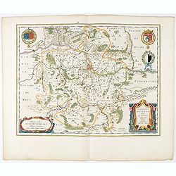
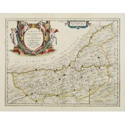
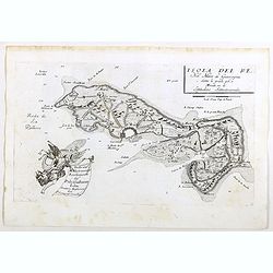
Picardia Regio Belgica.
Map of the northern region of Picardy. The region is well known due to the 4 major battles fought between France, Britain and Germany between 1915-18 during World War I. ...
- $400 / ≈ €352
Place & Date: Amsterdam, 1644

Veromanduorum.. Vermandois / Gouvernement de la Capelle.
A very decorative map with beautiful cartouches of a province of France by one of the most famous map publishers. Signed by Guilielmus Blaeu.From early on Willem Jansz. B...
- $220 / ≈ €194
Place & Date: Amsterdam, 1644

Le Gouvernement de l'Isle de France.
A very detailed map of Ile de France centered on Paris. Showing Beauvais, Compiègne, Noyon, Laon, Soisson, Vernon, Mante, Pontoise, Meaux, etc.Adorned with the royal arm...
- $300 / ≈ €264
Place & Date: Amsterdam, 1644
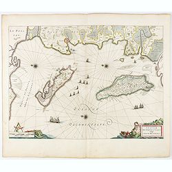
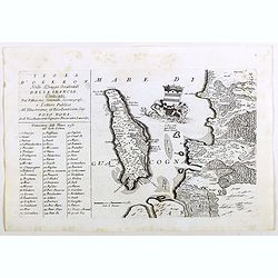
Insulae Divi Martini et Uliarus, vulgo L'Isle de Ré.. Oleron.
Map of Ré and Oléron islands. Depicting the west coast of France, showing La Rochelle. Several vessels and sailing ships dot the Atlantic ocean.Three windroses indicate...
- $950 / ≈ €836
Place & Date: Amsterdam, 1644

Britannia Ducatus. Duché de Bretaigne.
Map of Bretagne in France. From early on Willem Jansz. Blaeu aimed of publishing an atlas to compete with the Hondius-Jansson Atlas. By 1630, he had published at least 1...
- $650 / ≈ €572
Place & Date: Amsterdam, 1644
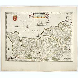
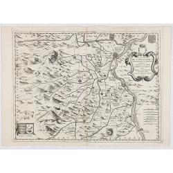
Normandia Ducatus.
Very detailed map of Normandy centered on Caen and Rouen. Also showing Cherbourg, Avranches, Bayeux, Cabourg, Honfleur, Le Havre, Etretat, Fecamp. St Malo and Mont Saint ...
- $400 / ≈ €352
Place & Date: Amsterdam, 1644
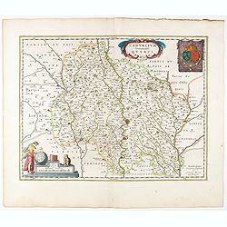
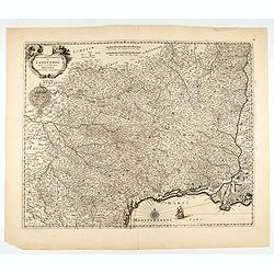
Cadurcium Vernaculé Querci.
Detailed map of a province of France by one of the most famous map publisher. Centered on Cahors.In the lower-left corner, a colored scale cartouche surmounted by a monke...
Place & Date: Amsterdam, 1644

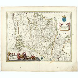
Xaintonge et Angoumois.
This map features a portion of western coastal France, north of Bordeaux with Ile de Ré and Ile Oléron. Two large cartouches show cherubs with grapes and wheat, and tw...
- $450 / ≈ €396
Place & Date: Amsterdam, 1644
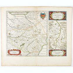
Lemovicum.. Lymosin. / Topographia Limaniae. . .
Two maps on one sheet. The author of the map of Lymosin was the French physician and cartographer Jean du Fayen. From early on Willem Jansz. Blaeu aimed of publishing an...
- $175 / ≈ €154
Place & Date: Amsterdam, 1644
Territorium Metense. Auctore Ab. Fabert.. Le Pais Messin.
A very decorative map of part of Lorraine with beautiful cartouches. Orientated with West on top. Centered on Metz. From early on Willem Jansz. Blaeu aimed of publishing...
- $300 / ≈ €264
Place & Date: Amsterdam, 1644

Les Souverainetez de Sedan et de Raucourt.. Doncheri.
A very decorative map with beautiful large cartouches of a province of France by one of the most famous map publishers. From early on Willem Jansz. Blaeu aimed of publis...
- $175 / ≈ €154
Place & Date: Amsterdam, 1644
Belsia vulgo La Beausse.
In the left-hand lower part of the image a beautiful contemporary cartouche with goddess Ceres [agricultural] holding a reaping-hook in her right hand and receiving with ...
- $200 / ≈ €176
Place & Date: Amsterdam , 1644

La ville archie-piscopale et primatiale de Vienne en Dauphiné.
View of Vienne, engraved by François de La Pointe.
- $600 / ≈ €528
Place & Date: Paris, 1648

Regnum Galliae. . .
Map of France from the rare atlas of the Capucin order: "Chorographica descriptio provinciarum, et conventum fratrum minorum S. Francisci Capucinorum…".
- $175 / ≈ €154
Place & Date: Turin, 1649
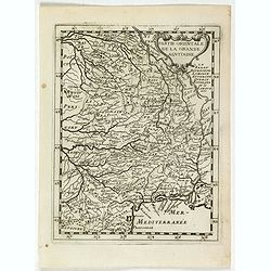
La partie orientale de la Grande Aquitaine.
Map taken from "Geographique Theater de l'Europe …, a rare work by the Jesuit priest Briet.
Place & Date: Paris, 1649

Dioecesis Sarlatensis, vernacule... Sarlat.
Impressive title cartouche with four putti. Detailed map of the region south of the Dordogne River from Bergerac till Saint-Cirq. Including Le Buisson.
Place & Date: Amsterdam 1650
Selling price: $180
Sold in 2009

Aniou. . .
Decorative map centered on the Loire valley. Fine title cartouche in upper right corner.
Place & Date: Amsterdam, 1650

Massilia - Marseille.
Detailed bird's-eye view of the town of Marseille. From Merian's Theatrum Europaeum. To the bottom a lettered key to the principal places in town.
Place & Date: Frankfurt 1650
Gouvernement General de l'Ile de France. . .
Fine map of Isle de France, centered on ParisThis edition carries the date 1651. Engraved by Jean Sommer.Nicolas Sanson was to bring about the rise of French cartography,...
- $200 / ≈ €176
Place & Date: Paris, 1651

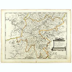
Nova Haec tabula Galliae. . .
Dated 1653. This handsome map of France is dedicated to Louis XIV, interesting in light of the nearly constant warfare between Louis and the Netherlands in the ensuing ye...
Place & Date: Amsterdam, 1653

L'evesché d'Aire. . .
In center Adour (river), Aire-sur-l'Adour, with Aire and Dax in lower right corner. Janssonius does give credit to Pierre du Val. In lower left corner putti with grapes.D...
- $300 / ≈ €264
Place & Date: Amsterdam, 1656

Dicecese de Rheims, et le païs de Rethel. . .
Centered on Rheims. A very decorative map with beautiful cartouches of a province of France by one of the most famous map publishers.
- $300 / ≈ €264
Place & Date: Amsterdam, 1658
Dioecesis Sarlatensis, Vernacule.. Sarlat.
Detailed map of the region south of the Dordogne River, depicting Bergerac, Saint Cyprien, Montignac, Sarlat, Villefranche, etc.Embellished with an impressive title carto...
- $200 / ≈ €176
Place & Date: Amsterdam, 1658
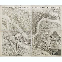
Description au naturel de la ville de Lyon et païsages alentour d'icelle.
PREMIERE EDITION. Plan de Lyon à « vol d’oiseau » commandé par le consulat, destiné à la diffusion et à la notoriété de la cité, mariant ainsi image de la vil...
Place & Date: Lyon, 1659
Flandria Gallica Continens Castellanias Insulense . . .
No text on verso. Map of northern part of France, centered on Lille and part of Belgium.
Place & Date: Amsterdam, c. 1660
Champaigne et Brie etc.
A good engraved map of Champagne-Ardenne area, embellished with decorative title cartouche and scale cartouche with putti and surveying instruments. Paris, Metz, Reims, a...
- $150 / ≈ €132
Place & Date: Paris, ca. 1660

Nova Haec tabula Galliae. . .
Dated 1660. This handsome map of France is dedicated to Louis XIV, interesting in light of the nearly constant warfare between Louis and the Netherlands in the ensuing ye...
Place & Date: Amsterdam, 1660

St Tropez.
Plan of St Tropez by M.Merian. Depicts a street layout and ships in harbour etc.
- $130 / ≈ €114
Place & Date: Frakfurt, 1660

France nouvellement descripte.
Rare map of France, published by Jollain in 1667. Published in "Trésor Des Cartes Geographiques Des Principaux Estats de Lunivers".This atlas is based upon Boi...
- $150 / ≈ €132
Place & Date: Paris, 1667

Comparse des Cinq Quadrilles dans l'Amphitheatre.
An early and intriguing engraving recording one of the most celebrated and spectacular festivals held at Paris by the young Louis XIV. The multi-day tournament took place...
Place & Date: Paris, imprimerie royale, 1670
The siege of Lagny.
Very rare etching of the siege of Lagny-sur-Marne by the Duc of Parma. Etched by Johann Azelt (1654-1692). A similar print but with the number in the upper right corner i...
- $150 / ≈ €132
Place & Date: Nuremberg, ca 1675
![S. Laurens in Franckr. [France].](/uploads/cache/13810-250x250.jpg)
S. Laurens in Franckr. [France].
A very nice view of the town of Saint Laurens in Alsace, with a church. On the foreground, an elephant and a rhinoceros are depicted. With a verse in two languages undern...
- $40 / ≈ €35
Place & Date: Frankfurt, 1623-1678
![Cordelirs in Franckr. [France].](/uploads/cache/13812-250x250.jpg)
Cordelirs in Franckr. [France].
A panoramic view of the town of Cordeliers (probably imaginary) with in the center the church. In the foreground a man hunting a wolf. With a verse in two languages under...
- $50 / ≈ €44
Place & Date: Frankfurt 1623-1678
![Cordelirs in Franckr. [France].](/uploads/cache/13811-250x250.jpg)
Cordelirs in Franckr. [France].
A panoramic view of the town of Cordelirs (probably imaginary) with in center the church. On the foreground a man hunting a wolve. With a verse in two languages underneat...
- $35 / ≈ €31
Place & Date: Frankfurt 1623-1678
![Cordelirs in Franckr. [France].](/uploads/cache/13736-250x250.jpg)
Cordelirs in Franckr. [France].
A very nice view of a monastery. With a verse in two languages underneath the picture.The poet and topographer from Comothau, Daniel Meisner (1585-1625), started his firs...
- $40 / ≈ €35
Place & Date: Frankfurt, 1623-1678
![In einem Todt. . . [ Chateau Chenonceaux ]](/uploads/cache/13817-250x250.jpg)
In einem Todt. . . [ Chateau Chenonceaux ]
A very nice depiction of Chateau Chenonceaux near Tours, France within the foreground is a dead lion, surrounded by rabbits. With a verse in two languages underneath the ...
- $50 / ≈ €44
Place & Date: Frankfurt, 1623-1678
![Cordelirs in Franckr. [France].](/uploads/cache/13799-250x250.jpg)
Cordelirs in Franckr. [France].
A very nice view of the town of Cordeliers. On the foreground, a man hunting a wolf is depicted. With a verse in German and Latin underneath the picture.The poet and topo...
- $80 / ≈ €70
Place & Date: Frankfurt, 1623-1678
![S. Victor in Franckr. [The Abbey of St. Victor near Paris.].](/uploads/cache/13769-250x250.jpg)
S. Victor in Franckr. [The Abbey of St. Victor near Paris.].
A very nice view of the Abbey of St. Victor near Paris. On the foreground, a night watchman is depicted. With a verse in two languages underneath the picture.The poet Dan...
- $60 / ≈ €53
Place & Date: Frankfurt, 1623-1678
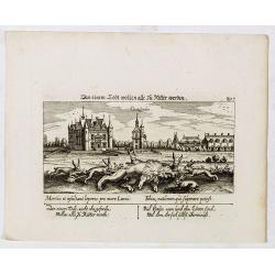
In einem Todt wollen alle zu Ritter werden.
A very nice view of a dead lion, surrounded by rabbits and in the background a French castle. With a verse in two languages underneath the picture. "In einem Todt, n...
- $70 / ≈ €62
Place & Date: Frankfurt, 1623-1678
![S. Victor in Franckr. [France].](/uploads/cache/13770-250x250.jpg)
S. Victor in Franckr. [France].
A very nice view of the church. On the foreground, a night watchman is depicted. With a verse in two languages underneath the picture.The poet and topographer from Comoth...
- $40 / ≈ €35
Place & Date: Frankfurt, 1623-1678
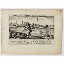
Aeqvum est, tristes secludere curas (Lianges.)
A very nice view of the city Lianges. With a verse in two languages underneath the picture.The poet and topographer from Comothau, Daniel Meisner (1585-1625), started his...
- $60 / ≈ €53
Place & Date: Frankfurt, 1623-1678
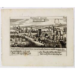
S. Iulius.
A very nice view of the castle of Saint Julius. On the foreground, several frogs are depicted. With a verse in two languages underneath the picture.The poet and topograph...
- $60 / ≈ €53
Place & Date: Frankfurt, 1623-1678

Vincennes - Viel hund Feind.des Hasen Todt.
A very nice picture representing Vincennes. With a verse in German and Latin. The German text reads : "Viel Hundt feind ja des Hasen Todr, Ihr viel bringn einen bald...
- $70 / ≈ €62
Place & Date: Frankfurt, 1623-1678
![S. Victor in Franckr. [Paris].](/uploads/cache/13781-250x250.jpg)
S. Victor in Franckr. [Paris].
A very nice view of St. Victor church in Paris. In the foreground, a night watchman is depicted. With a verse in Latin and German underneath the picture. The German text ...
- $60 / ≈ €53
Place & Date: Frankfurt, 1623-1678
Gouvernement General de Languedoc. Divise en ses Vint Deux Diocesez.
A lovely late seventeenth century map of the central south French region of Languedoc, part of which borders the Mediterranean Sea by Dutch publisher and cartographer, Fr...
- $250 / ≈ €220
Place & Date: Amsterdam, ca 1680

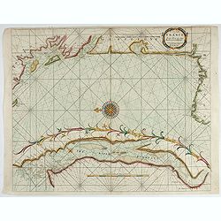
The Sea Coast of France from Ushent to Olone.
Chart showing the Brittany coast from Ushent to Ollone, with Belle-Ile. In insets : Rade de Brest and Mouth of the Loire between St. Nazaire and Nantes.Originally engrave...
Place & Date: London, ca. 1680
The Sea Coasts of France from Olone to Cape Machicaca in Biscay . . .
Detailed chart of Biscay Bay, showing the Coast of Brittany. The chart is oriented with north-east at the top and includes two large insets of the Loire River with Nantes...
Place & Date: London, ca. 1680
Veue de la ville, et fauxbourg de Salins…
Showing the town of Salins, a commune with salt works (Salines) in the Jura department in the region of Bourgogne-Franche-Comté in eastern France. With a key (1-15) in ...
- $700 / ≈ €616
Place & Date: Paris, ca. 1680
![Rumiliacum vulgo Rumilix. [Rumilly]](/uploads/cache/45513-250x250.jpg)
Rumiliacum vulgo Rumilix. [Rumilly]
Showing in great detail a bird's-eye view of the city of Rumilly in the Haute-Savoie, decorated with the coat of arms and a lettered key.From "Theatrum Sabaudiæ&quo...
- $150 / ≈ €132
Place & Date: Amsterdam, 1682
![Abbaye d'Hautecombe. [Hautecombe Abbey]](/uploads/cache/45512-250x250.jpg)
Abbaye d'Hautecombe. [Hautecombe Abbey]
Showing in great detail a bird's-eye view of the Hautecombe Abbey, a former Cistercian monastery, later a Benedictine monastery, in Saint-Pierre-de-Curtille near Aix-les-...
- $150 / ≈ €132
Place & Date: Amsterdam, 1682
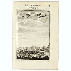
![France en general. [de l'Europe / Figure LXVII] 147](/uploads/cache/38437-250x250.jpg)
France en general. [de l'Europe / Figure LXVII] 147
A fine and uncommon early 17th century map of France.From the French text edition of "Description d'Univers", 1683. by Allain Manneson Mallet (1630-1706), a wel...
- $30 / ≈ €26
Place & Date: Paris, 1683
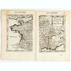
![Carte generale de France. [de l'Europe]](/uploads/cache/38442-250x250.jpg)
Carte generale de France. [de l'Europe]
A fine and uncommon early 17th century map of France printed from two copper plates. Engraved by Liébaux.From the French text edition of "Description d'Univers"...
- $80 / ≈ €70
Place & Date: Paris, 1683
![De l'Europe. [ Figure LXXXV].](/uploads/cache/38452-250x250.jpg)
De l'Europe. [ Figure LXXXV].
Decorative engraving showing "Ludovicus Magnus" or Louis XIV King of France, Coin Portrait.From the French text edition of "Description d'Univers", 16...
- $50 / ≈ €44
Place & Date: Paris, 1683
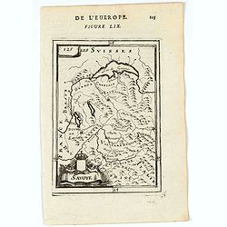
Savoye.
A charming map of Savoy. Title in a curtain draped at top. French text on verso.From the original 1683 text edition of "Description d'Univers. . ." by Allain Ma...
Place & Date: Paris, 1683
Chamberi.
A charming view of Chambery. Title in a curtain draped at top. French text on verso.From the original 1683 text edition of "Description d'Univers. . ." by Allai...
Place & Date: Paris, 1683

François.
A charming engraving of a French couple in 17th-century dress.Title in a curtain draped at top. French text on verso.From the original 1683 text edition of "Descript...
Place & Date: Paris, 1683
Carte generale de France.
A two-page map of France.Title in curtain draped at top. French text on verso.From the original 1683 text edition of "Description d'Univers. . ." by Allain Mane...
Place & Date: Paris, 1683
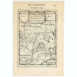
Royaume des… Royaume de Bourgogne sous la race des rois Bourguigons.
Map of Bourgogne region.Title in curtain draped at topFrom the original 1683 text edition of "Description d'Univers. . ." by Allain Manesson Mallet (1630-1706),...
Place & Date: Paris, 1683
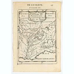
Royaume de Bourgogne sous la seconde race des roys de France.
Map of Bourgogne region.Title in a curtain draped at topFrom the original 1683 text edition of "Description d'Univers. . ." by Allain Manesson Mallet (1630-1706...
Place & Date: Paris, 1683
![Ancienne Gavle. [de l'Europe]](/uploads/cache/38440-250x250.jpg)
Ancienne Gavle. [de l'Europe]
A fine and uncommon early 17th century map of France.From the French text edition of "Description d'Univers", 1683. by Allain Manneson Mallet (1630-1706), a wel...
- $50 / ≈ €44
Place & Date: Paris, 1683

Le Coste della Francia sul Mare Oceano.
Uncommon map from "Mercurio Geografico", published in Rome by G. de Rossi. A decorative title and scale cartouches enriching the map. The Italian cartographer C...
- $375 / ≈ €330
Place & Date: Rome, 1690
Isola del Re Nel Mare di Guascogna . . .
A beautiful map showing Ile de Ré in Bretagne, located in the Bay of Biscay off the coast of France, from Vincenzo Coronelli's Corso Geografico Universale.Italian text o...
Place & Date: Venice, 1690
Isola d'Oleron, nella piaggie occidentali della Francia.
A beautiful and rare map showing île d'Oleron.The remarkable Vincenzo Coronelli (1650-1718), encyclopaedist, geographer, inventor and Doctor of Theology, was citizen of ...
Place & Date: Venice, 1690
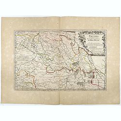
Partie Septentrionale de l'Evesché de Poictiers. Partie Septentrionale du Haut Poitou.
Rare map engraved by R. Michault and published "a Paris chez Greg. Mariette sur le quay de l'Horloge au dessus de la cour de Lamoignon". Dedicated to the Bishop...
- $125 / ≈ €110
Place & Date: Paris, 1690
Contado DE Venassino, E prencipato d'Oranges . . .
A most attractive and decorative map centered on Avignon and Orange, by Vincenzo Coronelli. An elaborate title cartouche garlanded with intertwined flowers and dedicated ...
- $400 / ≈ €352
Place & Date: Venise 1690

Veüe de Nice.
Engraved birds eye view of Nice. Shows rivers, canals, bridges, landmarks, farms and buildings. Relief shown pictorially.
Place & Date: Paris, 1692

Veue de Nice.
Engraved birds eye view of Nice. Shows rivers, canals, bridges, landmarks, farms and buildings. Relief shown pictorially.
Place & Date: Paris, 1692
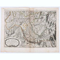
La Savoia divisa nelle sue Principali Provincie da Giacomo Cantelli da Vignola . . .
Late 17th century maps of the Savoy region, based on the reports of Giacomo Cantelli da Vignola and published in Roma in Giacomo de Rossi's world atlas Mercurio Geografic...
- $250 / ≈ €220
Place & Date: Rome, 1692
![[Lot of 15 maps/plans of northern France] Gouvernement d' Orleans et la Generalite divisee en ses Elections.](/uploads/cache/19853-250x250.jpg)
[Lot of 15 maps/plans of northern France] Gouvernement d' Orleans et la Generalite divisee en ses Elections.
Alexis-Hubert Jaillot (1632-1712), French cartographer. He joined the Sanson heirs and redrew Nicolas Sanson's maps on a larger scale. 'Atlas Nouveau' (1674), sea-atlas '...
- $500 / ≈ €440
Place & Date: Amsterdam, Paris, 1693

Disegno Idrografico del Canale Reale . . .
A decorative Coronelli map showing the Canal du Midi. It shows the extent of the canal from the Mediterranean sea at Narbonne to Toulouse. Featuring a pair of large coats...
- $300 / ≈ €264
Place & Date: Venice, 1695-1697
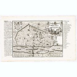
Orleans.
Nice scarce detailed town-plan of Orleans, from Bodenehr's "Atlas curieux" published in Augsburg.Incredibly detailed, shows the city of Orleans with many place ...
- $150 / ≈ €132
Place & Date: Augsburg, ca. 1700
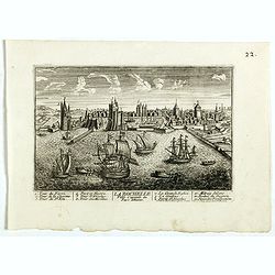
La Ville de la Rochelle, Capitale du pays d'Aunis. . .
A very decorative town view of La Rochelle.
- $350 / ≈ €308
Place & Date: Paris, 1700
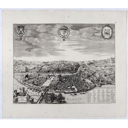
Lugdunum vulgo Lyon.
SCARCE bird's-eye view of Lyon. Adorned with a title cartouche at bottom left, a cartouche at bottom right containing the legend with key tables 1-98 and three coats of a...
- $1000 / ≈ €880
Place & Date: Amsterdam, ca. 1700
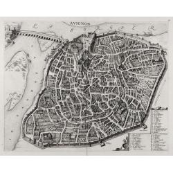
Avignon.
SCARCE bird's-eye view of Avignon (Provence) figuring the Popes' Palace and the fortifications. Adorned with a cartouche at bottom right containing the legend with key ta...
- $1000 / ≈ €880
Place & Date: Amsterdam, ca. 1700
La France avec ses acquisitions jusqu'à l'année 1705.
An interesting small map of France by Nicolas de Fer. From his rare "Petit et Nouveau Atlas". The first edition was published in 1697 and was republished in 170...
- $75 / ≈ €66
Place & Date: Paris, 1705

Plan d'un marais salant . . .
Aerial view of a salt marsh, with depiction of working scenes and a nice cartouche, from Nicolas de Fer's "L'Atlas curieux ou le Monde réprésente dans des cartes. ...
Place & Date: Paris, 1705

Gouvernement general de Languedoc . . .
Map of the Languedoc region, from Nicolas de Fer's "L'Atlas curieux ou le Monde réprésente dans des cartes. "The "Atlas Curieux" is a geographic enc...
Place & Date: Paris, 1705

Souveraineté de Neuchatel et de Vallangin.
Map of the Neuchatel region, from Nicolas de Fer's "L'Atlas curieux ou le Monde réprésente dans des cartes. "The "Atlas Curieux" is a geographic enc...
Place & Date: Paris, 1705

Les Provinces, ou Gouvernement de Poictou, d'Anjou, du Maine, De Touraine . . .
Map centered on Loire region, with Blois, Saumur, Sancerre and Orleans, from Nicolas de Fer's "L'Atlas curieux ou le Monde réprésente dans des cartes. "The &q...
Place & Date: Paris, 1705
Gouvernement general du Lionnois, generalitez de Lion et de Riom . . .
Map of central France with Clermont-Ferrand and Lyon to the right, from Nicolas de Fer's "L'Atlas curieux ou le Monde réprésente dans des cartes. "The "A...
Place & Date: Paris, 1705