Browse Listings in Europe > Eastern Europe > Czech Republic / Moravia
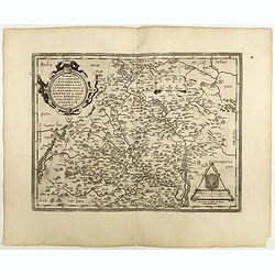
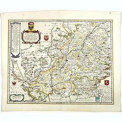
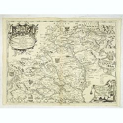
Moraviae.
This early map of Slovakia was prepared by Paul Fabritius in 1569, centered on the city of Brno. Title cartouche on the upper left corner. Abraham Ortelius (1527-1598) wa...
Place & Date: Antwerp, 1598
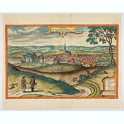
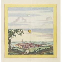
Polna vulgo Polm insign : Bohemia. . .
This is a view of Polna from the southwest looking across the Bohemian-Moravian Highlands from a slightly elevated viewpoint. In addition to the parish church (D) in the ...
Place & Date: Cologne, 1617
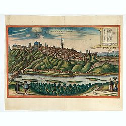
Znaymum vulgo Znaym, Moraviae Civitas Primaria.
Rare bird's-eye view of Znojmo (Znaim) Key to 12 locations.COMMENTARY BY BRAUN: "This is a beautiful and wealthy city in Moravia, situated on the border to Austria o...
- $750 / ≈ €660
Place & Date: Cologne, 1618
Bützom.
Very decorative and rare panoramic town view of Bützom.The engraver and publisher of prints, Mrs. Anna Beek of the Hague, enlarged the print and mounted it on larger pap...
Place & Date: The Hague, ca. 1642
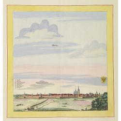
Werben.
Very decorative and rare panoramic town view of Werben a.d. Elbe, Bez. Magdeburg.The engraver and publisher of prints, Mrs. Anna Beek of the Hague, enlarged the print and...
Place & Date: The Hague, ca. 1642
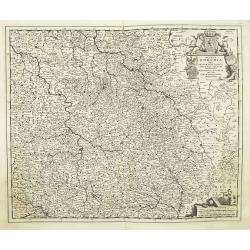
Silesia Inferior. . .
Decorative map prepared by Jonas Scultetus, a Silesian cartographer (1603-1664). More about Willem Blaeu. [+]
- $300 / ≈ €264
Place & Date: Amsterdam, 1644
Konigreich Boheim. Royaume de Boheme. . .
Covering Czech Republic and centered on Prague. Nicolas Sanson was to bring about the rise of French cartography, although the fierce competition of the Dutch would last ...
- $300 / ≈ €264
Place & Date: Paris, 1654
Konigreich Boheim. Royaume de Boheme..
Covering Czech Republic and centered on Prague. This edition carries the date 1654.Nicolas Sanson was to bring about the rise of French cartography, although the fierce c...
Place & Date: Paris, 1654
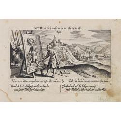
Villec.
A very nice view the town of Villeck in Czechoslovakia. On the foreground, a man examining a painting is depicted. With a verse in two languages underneath the picture.Th...
- $75 / ≈ €66
Place & Date: Frankfurt, 1623-1678
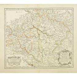
Regnum Bohemia.. Silesia.. Moravia, et Lusatia..
Detailed map of Czechoslovakia including the towns of Dresden, Prague, Breslau, etc. With fine title cartouche upper left, putti carrying the coats of arms of Bohemia, Mo...
- $400 / ≈ €352
Place & Date: Amsterdam, 1680
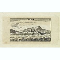
Palota.
Panoramic view of Palota in the Medzilaborce District in the Prešov Region of far north-eastern Slovakia. Published in "Der Donau-Strand Mit allen seinen Ein- und Z...
- $150 / ≈ €132
Place & Date: Nuremberg, Jacob Sandrart, 1684
Il Ducato di Silesia et il Marchesato di Moravia
Scarce two-sheet map of the region along the River Oder in Poland, including parts of Chez Republic and Hungary. Excellent detail throughout. Large and decorative title a...
- $1200 / ≈ €1057
Place & Date: Rome, 1692
![Praghe. [ Prague ]](/uploads/cache/27801-250x250.jpg)
Praghe. [ Prague ]
A rare panoramic of Prague with over the whole length of the lower part 3 columns of poems in Dutch, French, German and English.Frederick de Wit published after 1694 a t...
- $2100 / ≈ €1849
Place & Date: Amsterdam, 1694
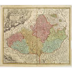
Marcomania hoggidi Merchesato de Moravia. . .
Although Komensky's map of Moravia was already known in his time, Coronelli used the obsolete map by Fabricius, with a lot of locations added by the publisher's unchained...
Place & Date: Venice, 1696
Laûn.
Very decorative and rare panoramic of Laun Louny a.d. Eger Böhmen.The engraver and publisher of prints, Mrs. Anna Beek of the Hague, enlarged the print and mounted it o...
Place & Date: The Hague, ca. 1700
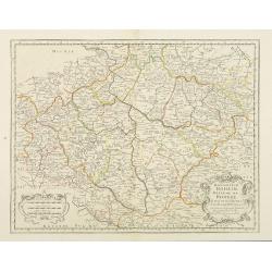
In Bohemia Moravia et Silesia . . .
A map of Czechoslovakia with Poland in the upper corner. Including the River Oder and Wroclaw (Breslaw)Heinrich Scherer (1628-1704) taught as Professor of Hebrew, Mathema...
- $175 / ≈ €154
Place & Date: Munich c.1710
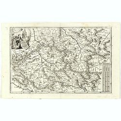
Marchionatus Moraviae circulus brunnensis. . .
Johann Baptist Homann's well-engraved map has a large decorative cartouche. Detailed map centered on Bruenn in Moravia. Prepared by Johann Chr. Mueller. Very decorative t...
- $300 / ≈ €264
Place & Date: Nuremberg, 1740

Plan de Prague.
Rare and separately published plan of Prague published by Joan Baptista Nolin with the address à l'enseigne de la Place des Victoires et chez le Sr. Humblot rue St. Jacq...
- $550 / ≈ €484
Place & Date: Paris, ca. 1742
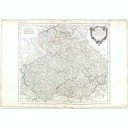
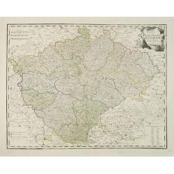
Tabula Generalis Marchionatus Moraviae..
Johann Baptist Homann's well-engraved map has a large decorative cartouche. Detailed map of the historic Moravia region of the Czech Republic, in the present-day Jihormor...
- $275 / ≈ €242
Place & Date: Nuremberg 1744
Marchionatus Moraviae circulus brunnensis..
Johann Baptist Homann's well-engraved map has a large decorative cartouche. Detailed map centered on Brunnensis, showing the main cities. Very decorative title cartouche ...
Place & Date: Nuremberg, 1744
Selling price: $200
Sold in 2008
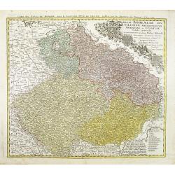
Regni Bohemiae, Duc. Silesiae, Marchionatuum Moraviae et Lusatiae. . .
Johann Baptist Homann's well-engraved map including the towns of Prague, Poznan/ Loda, Wroclaw, etc.This example was printed from plate A (1st of 3), which can be identif...
- $200 / ≈ €176
Place & Date: Nuremberg, ca. 1748
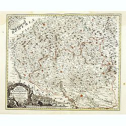
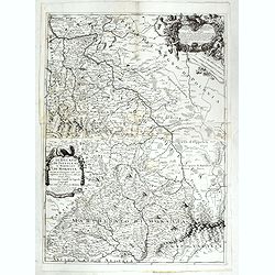
Marchionatus Moraviae circuli Znoymensis et Iglaviensis. . .
Map of the Znaym region of Moravia, the southern part of the Czech Republic, with figurative cartouche and small table of explanations. After Johann Christoph Müller pub...
- $250 / ≈ €220
Place & Date: Nuremberg, 1750
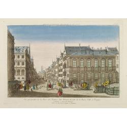
Vue perspective de la Place des Peintres ditte Perlach du cote de la Basse Ville a Prague.
A so-called optical print of a square in Prague by Basset, a well-known publisher of optical prints, was established in rue S.Jacques in Paris. With brief key list.In the...
- $300 / ≈ €264
Place & Date: Paris, 1760
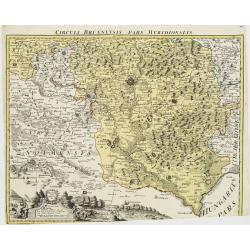
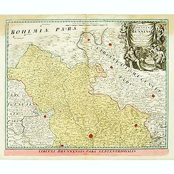
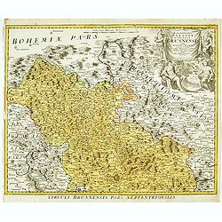
Circuli Brunnensis Pars Meridionalis.
Johann Baptist Homann's well-engraved and detailed map of the present-day South Moravia region centered on Brno, with decorative cartouche at the bottom.Johann Baptist Ho...
Place & Date: Nuremberg 1770 - 1774
Selling price: $250
Sold in 2008
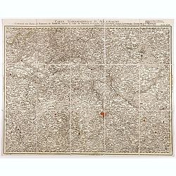
Carte topographique d'Allemagne contenant une partie du royaume de Boheme. . .
Detailed map cantered on Prague, Caaden, Laim, Melnik… Map 43 of the multi sheet map "Carte topographique d'Allemagne" of German Empire. Published by Johann W...
- $100 / ≈ €88
Place & Date: Frankfurt, ca.1780
Le Royaume de Boheme.. Moravie et Lusace.
Finely and crisply engraved map of Czechoslovakia, including Pilsen and part of Poland.Venetian edition of Giles Didier Robert De Vaugondy's map from Atlas Universel prin...
- $150 / ≈ €132
Place & Date: Venice, 1777 - 1784
Karte von dem Konigreiche Boheim.
An attractive map of Bohemia. With a nice title cartouche decorated with cherubs in the upper right-hand corner. Engraved by Kil. Ponheimer.Franz Johann Josef von Reilly ...
- $300 / ≈ €264
Place & Date: Vienna, 1796
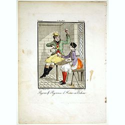
Paysan & Paysanne d'Hanas en Boheme.
Originally hand-colored mezzotint from 'Costumes civils actuels de tous les peuples connus'. Engraved by Lachaussée Jeune after Jacques Grasset de Saint-Sauveur.As an et...
- $50 / ≈ €44
Place & Date: Paris,1805
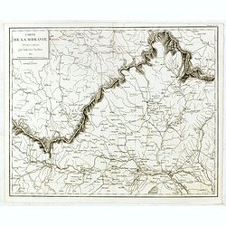
Carte de Moravie Dessinée et Gravée par Ambroise Tardieu.
Very detailed map including Vienna and the Czech Republic with Prague Olmutz.
- $40 / ≈ €35
Place & Date: Paris, 1822
![[Czech Republic] Provincia ecclesiastica di Praga nell' Impero Austriaco (Tav LXVIII)](/uploads/cache/44108-250x250.jpg)
[Czech Republic] Provincia ecclesiastica di Praga nell' Impero Austriaco (Tav LXVIII)
A large-format map of Czech Republic centered on Prague with its different dioceses. The map is finely engraved and beautifully colored and was prepared by Girolamo Pet...
- $300 / ≈ €264
Place & Date: Rome, 1858