Browse Listings in Europe > Eastern Europe
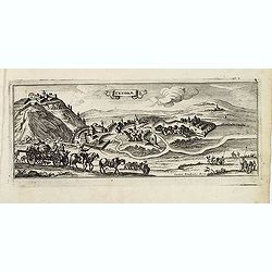
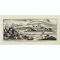
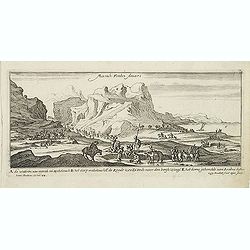
Sandrae. (Szendrö)
Magnificent bird's eye- of Szendrö. Etched by Gaspar Bouttats (1640-1695).The Antwerp based publisher Jacques Peeters published ca. 1690 a series of prints related to th...
- $100 / ≈ €88
Place & Date: Antwerp, c.1690
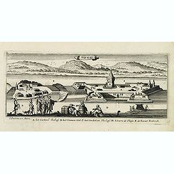
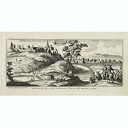
Tockay. (Tokaj)
Magnificent bird's eye- of Tokaj. Etched by Gaspar Bouttats (1640-1695).The Antwerp based publisher Jacques Peeters published ca. 1690 a series of prints related to the H...
- $150 / ≈ €132
Place & Date: Antwerp, c.1690
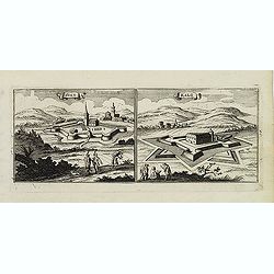
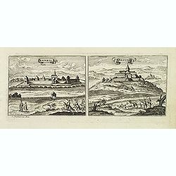
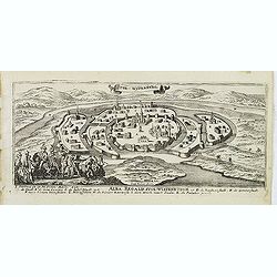
Sixo / Kalo. (Szikszo and Nagycallo)
Magnificent bird's eye- of Szikszo and Nagycallo. Etched by Gaspar Bouttats (1640-1695).The Antwerp-based publisher Jacques Peeters published ca. 1690 a series of prints ...
- $75 / ≈ €66
Place & Date: Antwerp, c.1690
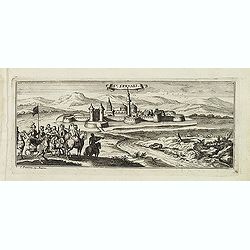
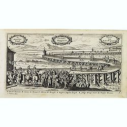
St:Servaes. (Szarvas)
Magnificent bird's eye- of Szarvas. Etched by Gaspar Bouttats (1640-1695).The Antwerp based publisher Jacques Peeters published ca. 1690 a series of prints related to the...
- $150 / ≈ €132
Place & Date: Antwerp, c.1690
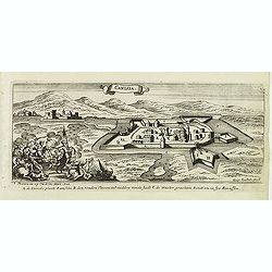
Canisia.
Magnificent bird's eye- of Nagykanizas. Etched by Gaspar Bouttats (1640-1695).The Antwerp based publisher Jacques Peeters published ca. 1690 a series of prints related to...
- $90 / ≈ €79
Place & Date: Antwerp, c.1690
Nembti / Sengrot.
Magnificent bird's eye-town-views of Lenti and Zalaszengrot. Etched by Gaspar Bouttats (1640-1695).The Antwerp based publisher Jacques Peeters published ca. 1690 a series...
- $80 / ≈ €70
Place & Date: Antwerp, c.1690
St Martinsbergh.
Magnificent bird's eye- of Pannonhalma (Szentmártonhegy). Etched by Gaspar Bouttats (1640-1695).The Antwerp based publisher Jacques Peeters published ca. 1690 a series o...
- $75 / ≈ €66
Place & Date: Antwerp, c.1690
Schombock.
Magnificent bird's eye- of Zsambek. Etched by Gaspar Bouttats (1640-1695).The Antwerp based publisher Jacques Peeters published ca. 1690 a series of prints related to the...
- $75 / ≈ €66
Place & Date: Antwerp, c.1690
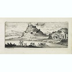
Palotta.
Magnificent bird's eye- of Varpalota. Etched by Gaspar Bouttats (1640-1695).The Antwerp based publisher Jacques Peeters published ca. 1690 a series of prints related to t...
Place & Date: Antwerp, c.1690
Vesprin.
Magnificent bird's eye- of Veszprem. Etched by Gaspar Bouttats (1640-1695).The Antwerp based publisher Jacques Peeters published ca. 1690 a series of prints related to th...
- $125 / ≈ €110
Place & Date: Antwerp, c.1690
Stoe-Wysenburg.
Magnificent bird's eye- of Szekesfehervar. Etched by Gaspar Bouttats (1640-1695).The Antwerp based publisher Jacques Peeters published ca. 1690 a series of prints related...
- $125 / ≈ €110
Place & Date: Antwerp, c.1690
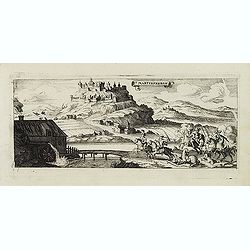
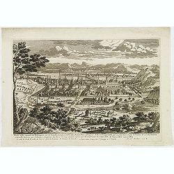
Esseker brugh.
Fine print of the Esseker bridge in Osijek. Etched by Gaspar Bouttats (1640-1695).The Antwerp based publisher Jacques Peeters published ca. 1690 a series of prints relate...
- $125 / ≈ €110
Place & Date: Antwerp, c.1690
Guyla.
Magnificent bird's eye- of Gyula. Etched by Gaspar Bouttats (1640-1695).The Antwerp based publisher Jacques Peeters published ca. 1690 a series of prints related to the H...
- $125 / ≈ €110
Place & Date: Antwerp, c.1690
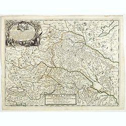
Parte della Schiavonia, overo Slavonia, aggiuntavi la contea di Cilles e Windisch mark abitate da populi slavini, ò slavi. . .
The map of Slavonia by Cantelli from his atlas “Mercurio Geografico” issued in Rome in 1690 by the publisher and printer Giacomo Rossi. The map shows parts of the med...
- $400 / ≈ €352
Place & Date: Rome, 1690
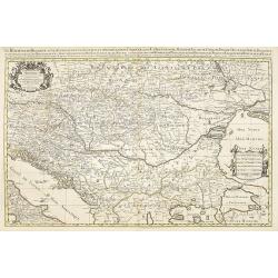
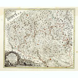
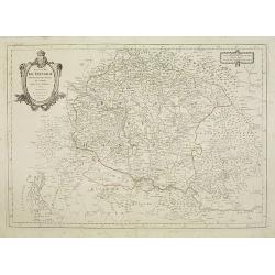
Le Royaume de Hongrie.
Fine oversized map of Hungary, but including Bosnia and Herzegovina, Bulgaria, Croatia, Romania, Albania, European part of Turkey, and Ukraine. With a decorative title an...
Place & Date: Amsterdam, 1692
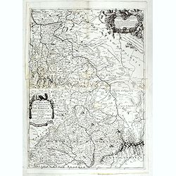
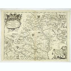
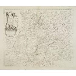
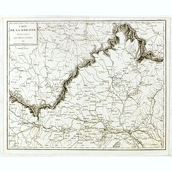
Il Ducato di Silesia et il Marchesato di Moravia
Scarce two-sheet map of the region along the River Oder in Poland, including parts of Chez Republic and Hungary. Excellent detail throughout. Large and decorative title a...
- $1200 / ≈ €1057
Place & Date: Rome, 1692
![Praghe. [ Prague ]](/uploads/cache/27801-250x250.jpg)
Praghe. [ Prague ]
A rare panoramic of Prague with over the whole length of the lower part 3 columns of poems in Dutch, French, German and English.Frederick de Wit published after 1694 a t...
- $2100 / ≈ €1849
Place & Date: Amsterdam, 1694
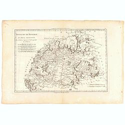
Marcomania hoggidi Merchesato de Moravia. . .
Although Komensky's map of Moravia was already known in his time, Coronelli used the obsolete map by Fabricius, with a lot of locations added by the publisher's unchained...
Place & Date: Venice, 1696
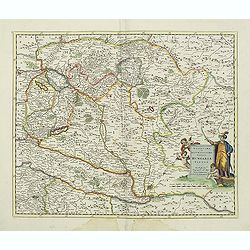
Novissima et accuratissima totius Hungariae tabula. . .
Detailed map of Hungary with a decorative title cartouche with putti and an Ottoman warrior. The publisher gives credit to P. du Val in the title cartouche.
Place & Date: Amsterdam, 1700
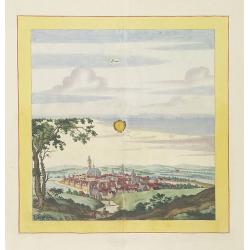
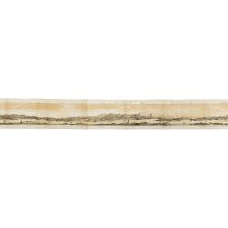
Laûn.
Very decorative and rare panoramic of Laun Louny a.d. Eger Böhmen.The engraver and publisher of prints, Mrs. Anna Beek of the Hague, enlarged the print and mounted it o...
Place & Date: The Hague, ca. 1700
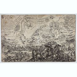
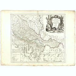
Delineatione della Piazza Forza di Belgrado.
Bird's-eye-bird view of The siege of Belgrade by the Austrian troops under the command of Prince Eugene of Savoy to capture the strategically important city from the Otto...
Place & Date: Rome, ca. 1700
![Le Cours du Danube. . .[2 maps].](/uploads/cache/28472-250x250.jpg)
Le Cours du Danube. . .[2 maps].
Detailed two-sheet map of the course of the River Danube from its source up to Vienna. Showing the cities, like Linz, Passau, Straubing, Regensburg, Ulm, Augsburg, Munich...
- $450 / ≈ €396
Place & Date: Paris, 1705
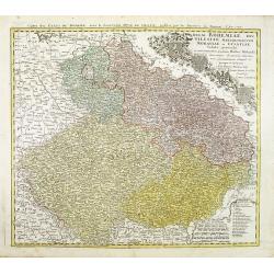
In Bohemia Moravia et Silesia . . .
A map of Czechoslovakia with Poland in the upper corner. Including the River Oder and Wroclaw (Breslaw)Heinrich Scherer (1628-1704) taught as Professor of Hebrew, Mathema...
- $175 / ≈ €154
Place & Date: Munich c.1710
Bude Ville capitale de la Hongrie.
A rare panoramic town-view of the city of Budapest. Engraved by Pierre Aveline (Paris, c.1656 - 23 May 1722). He was also a print-publisher and print-seller. He probably...
- $400 / ≈ €352
Place & Date: Paris, 1690-1730
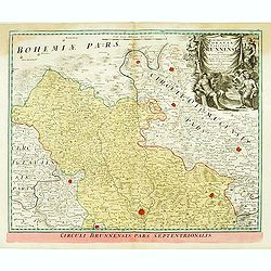
Marchionatus Moraviae circulus brunnensis. . .
Johann Baptist Homann's well-engraved map has a large decorative cartouche. Detailed map centered on Bruenn in Moravia. Prepared by Johann Chr. Mueller. Very decorative t...
- $300 / ≈ €264
Place & Date: Nuremberg, 1740
![[Portrait] - Me De Cet Corona se X+I. - Contantia et Fortudine](/uploads/cache/43510-250x250.jpg)
[Portrait] - Me De Cet Corona se X+I. - Contantia et Fortudine
Portrait of German Emperor Charles VI with his motto "Contantia et Fortudine". Holy Roman Emperor, 1711-1740, and King of Hungary as Charles III (1712-1740). Wi...
Place & Date: Germany, 1740
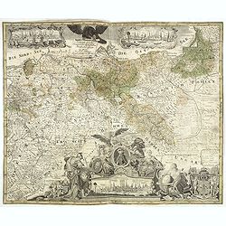
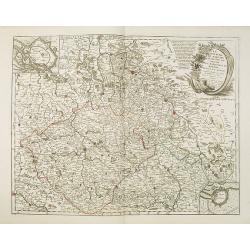
Rom: Keyserl. Majest. Königl Hoher Allierten Kriegs Theatrum von Schlesien, Böhmen, Maehren u: Oestereich. . .
A rare map centred on Austria, eastern Germany, Poland and Tsjechië. In upper right corner an inset plan of Prague. Showing the situation of the first Silesian War of 17...
- $900 / ≈ €792
Place & Date: Nuremberg, 1742

Plan de Prague.
Rare and separately published plan of Prague published by Joan Baptista Nolin with the address à l'enseigne de la Place des Victoires et chez le Sr. Humblot rue St. Jacq...
- $550 / ≈ €484
Place & Date: Paris, ca. 1742
Marchionatus Moraviae circulus brunnensis..
Johann Baptist Homann's well-engraved map has a large decorative cartouche. Detailed map centered on Brunnensis, showing the main cities. Very decorative title cartouche ...
Place & Date: Nuremberg, 1744
Selling price: $200
Sold in 2008
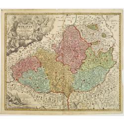
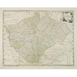
Tabula Generalis Marchionatus Moraviae..
Johann Baptist Homann's well-engraved map has a large decorative cartouche. Detailed map of the historic Moravia region of the Czech Republic, in the present-day Jihormor...
- $275 / ≈ €242
Place & Date: Nuremberg 1744
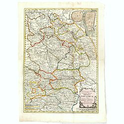
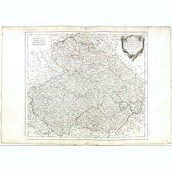
Regni Bohemiae, Duc. Silesiae, Marchionatuum Moraviae et Lusatiae. . .
Johann Baptist Homann's well-engraved map including the towns of Prague, Poznan/ Loda, Wroclaw, etc.This example was printed from plate A (1st of 3), which can be identif...
- $200 / ≈ €176
Place & Date: Nuremberg, ca. 1748
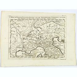
A Map of Gallia, Cisalpina, Liguria and the Neighbouring Countries.
A map of eastern France, Provence, northern Italy, then to Tuscany, whilst also showing northern Switzerland and Bavaria in Roman times. Showing Roman Provinces, a mileag...
- $50 / ≈ €44
Place & Date: London, ca 1749
Marchionatus Moraviae circuli Znoymensis et Iglaviensis. . .
Map of the Znaym region of Moravia, the southern part of the Czech Republic, with figurative cartouche and small table of explanations. After Johann Christoph Müller pub...
- $250 / ≈ €220
Place & Date: Nuremberg, 1750
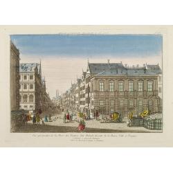
Vue perspective de la Place des Peintres ditte Perlach du cote de la Basse Ville a Prague.
A so-called optical print of a square in Prague by Basset, a well-known publisher of optical prints, was established in rue S.Jacques in Paris. With brief key list.In the...
- $300 / ≈ €264
Place & Date: Paris, 1760
Generale Carte der gesamten Koniglichen Preussischen Lander. . .
Beautiful and rare two sheet map of Prussia. The title cartouche is hold by a crowned eagle. In lower part a large baroque cartouche with allegorical figures and a portra...
- $1200 / ≈ €1057
Place & Date: Berlin, 1760
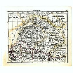
Kingdom of Hungary.
Uncommon miniature map of Hungary, engraved by Thomas Kitching for "A New General and Universal Atlas Containing Forty five Maps by Andrew Dury".This miniature ...
- $75 / ≈ €66
Place & Date: London, 1761-1763
Royaume de hongrie et Pays Adjacents.
Map of the Northern part of the Kingdom of Naples, by Rigobert Bonne.
- $50 / ≈ €44
Place & Date: Paris, 1771
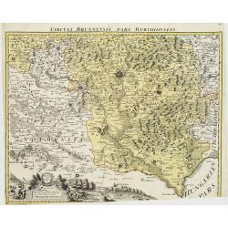
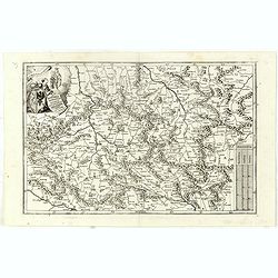
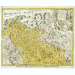
Circuli Brunnensis Pars Meridionalis.
Johann Baptist Homann's well-engraved and detailed map of the present-day South Moravia region centered on Brno, with decorative cartouche at the bottom.Johann Baptist Ho...
Place & Date: Nuremberg 1770 - 1774
Selling price: $250
Sold in 2008
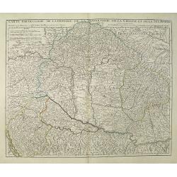
Carte Particuliere de la Hongrie de la Transilvanie de la Croatie et de la Sclavonie Dressée sur les Onservations de Mr. Le Comte Marsilli. . . Par G. Delisle.
Map of Hungary and Slovakia and adjacent parts of Croatia, Serbia and Romania (Transylvania). Prepared by Marsilli, published by Dezauche.
Place & Date: Paris, ca. 1780
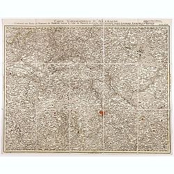
Carte topographique d'Allemagne contenant une partie du royaume de Boheme. . .
Detailed map cantered on Prague, Caaden, Laim, Melnik… Map 43 of the multi sheet map "Carte topographique d'Allemagne" of German Empire. Published by Johann W...
- $100 / ≈ €88
Place & Date: Frankfurt, ca.1780
![[No title] Part of Eastern Europe, including Poland, the Czech Republic, Slovakia and Slovenia.](/uploads/cache/24266-250x250.jpg)
[No title] Part of Eastern Europe, including Poland, the Czech Republic, Slovakia and Slovenia.
Attractive map showing part of the course of the river Danube, from Germany to Hungary.Including Poland, the Czech Republic, Slovakia and Slovenia. Boundaries outlined in...
- $100 / ≈ €88
Place & Date: Paris, ca 1783
Royaume de Hongrie.
Detailed map encompassing present day Hungary with the river Danube and the towns of Belgrade, Budapest, Vienna, etc.Venetian edition of the map by Bellin, to whom Santin...
Place & Date: Venice, 1776 - 1784
Principauté de Transilvanie et Pays circonvoisins..
Detailed map encompassing part of present-day Hungary.From "Atlas Universel" published by Santini in 1784. The atlas is effectively an Italian copy of the Rober...
Place & Date: Venice, 1784
Royaume d'Esclavonie et du Duché De Syrmie..
Detailed map encompassing show us Danube and to the right Belgrade.From "Atlas Universel" published by Santini in 1776-84. The atlas is effectively an Italian c...
Place & Date: Venice, 1776 - 1784
Selling price: $70
Sold in 2015
Le Royaume de Boheme.. Moravie et Lusace.
Finely and crisply engraved map of Czechoslovakia, including Pilsen and part of Poland.Venetian edition of Giles Didier Robert De Vaugondy's map from Atlas Universel prin...
- $150 / ≈ €132
Place & Date: Venice, 1777 - 1784
Le Royaume de Boheme, le Duché de Silesie, et les Marquisats de Moravie et Lusace, dresses d'apres les cartes de Muller . .
Map of Poland, Bohemia, Silesia, Moravia and Lusatia. Large decorative title cartouche in upper right. In upper left corner inset plan of Breslau and in lower right a ins...
Place & Date: Paris, 1790
Karte von dem Konigreiche Boheim.
An attractive map of Bohemia. With a nice title cartouche decorated with cherubs in the upper right-hand corner. Engraved by Kil. Ponheimer.Franz Johann Josef von Reilly ...
- $300 / ≈ €264
Place & Date: Vienna, 1796
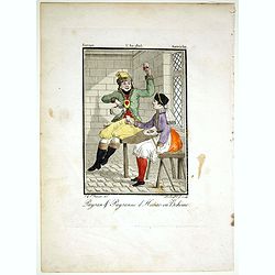
Paysan & Paysanne d'Hanas en Boheme.
Originally hand-colored mezzotint from 'Costumes civils actuels de tous les peuples connus'. Engraved by Lachaussée Jeune after Jacques Grasset de Saint-Sauveur.As an et...
- $50 / ≈ €44
Place & Date: Paris,1805
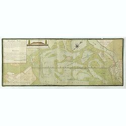
Situations = Plan. Der gegend zwischen der Kayserlich Königlichen Granitz Festung Essegg, und dem Dorffe Bellia....
Manuscript plan showing the Kopački Rit nature park a swampy area of Baranja between Osijek (Essegg) and Bilje. The river Drava in upper right corner. The pen an...
Place & Date: Vienna, 1819
Carte de Moravie Dessinée et Gravée par Ambroise Tardieu.
Very detailed map including Vienna and the Czech Republic with Prague Olmutz.
- $40 / ≈ €35
Place & Date: Paris, 1822
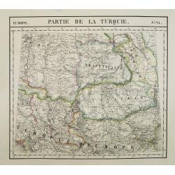
Europe. Partie de la Turquie. N°21.
Detailed map including Hungary and Romania.From his famous Atlas Universel . This atlas was one of the most remarkable world atlases ever produced, anticipating the Inter...
Place & Date: Brussels, 1825-1827
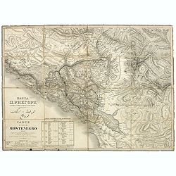
Carte du pays de Montenegro dressée d'après les opérations géodétiques . . .
Rare map of Montenegro prepared by Mr. le Comte Fedor de Karacsay (1787-1859) and engraved by Pietro Allodi. The title is in Russian, Arabic and French.In lower left corn...
- $1250 / ≈ €1101
Place & Date: Vienna, ca. 1838
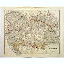
Austrian Empire.
A, large steel engraved map of the mighty Austrian Empire, covering Austria, Dalmatia, Styria, Slavonia, Hungary, Transylvania, Moravia and Bohemia. An enormous amount of...
Place & Date: London, 1839
Panorama della Costa e delle Isole di Dalmazia nei viaggi dei piroscafi del Lloyd Austriaco.
On 20 August 1838 the Austrian Lloyd inaugurated a line service from Trieste to the Mouth of Cattaro. In order to illustrate the route, the Company asked the Trieste pain...
- $2500 / ≈ €2201
Place & Date: Trieste, Linassi, 1857
![[Czech Republic] Provincia ecclesiastica di Praga nell' Impero Austriaco (Tav LXVIII)](/uploads/cache/44108-250x250.jpg)
[Czech Republic] Provincia ecclesiastica di Praga nell' Impero Austriaco (Tav LXVIII)
A large-format map of Czech Republic centered on Prague with its different dioceses. The map is finely engraved and beautifully colored and was prepared by Girolamo Pet...
- $300 / ≈ €264
Place & Date: Rome, 1858
![Environs de Raguse (Dubrovnik). Deuxième Feuille. Canal de Calamota (Kolocep).. [277]](/uploads/cache/23473-250x250.jpg)
Environs de Raguse (Dubrovnik). Deuxième Feuille. Canal de Calamota (Kolocep).. [277]
This large-scale coastal chart shows the stretch of the Dalmatian coast between Slano as far as the island of Kolocep, the southernmost inhabited island in Croatia. With ...
- $200 / ≈ €176
Place & Date: Paris [1877] corrected to 1932
![Mer Adriatique. Côte Orientale. De l'Ile Meleda à Antivari.. [3552]](/uploads/cache/23471-250x250.jpg)
Mer Adriatique. Côte Orientale. De l'Ile Meleda à Antivari.. [3552]
This large scale coastal chart shows the stretch of Dalmatian coast between the island Mljet in Croatia as far as Ulcinj (Montenegro). With latitude and longitude scales,...
- $200 / ≈ €176
Place & Date: Paris [1877] corrected to 1934
![Mer Adriatique. Partie Sud.. [3976]](/uploads/cache/23549-250x250.jpg)
Mer Adriatique. Partie Sud.. [3976]
This large scale coastal chart centered on the southern part of the Adriatic sea. Showing the Dalmatian coast between Split in Croatia as far as the northernmost tip of C...
- $200 / ≈ €176
Place & Date: Paris [1883] updated for 1935
MEMORANDUM Vlade Demokratske Federativne Jugoslavije po pitanju Juliske Krajine i drugih jugoslavenskih teritorija pod Italijom.
Memorandum of the government of the Democratic Federative Yugoslavia concerning the questions of the Jilian March and other Yugoslav territories under Italy.Julian March ...
- $300 / ≈ €264
Place & Date: London, 1946