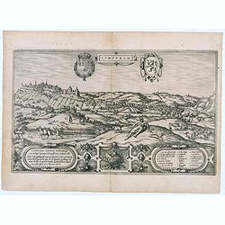
Lympurch. (Limburg)
Very desirable and early town-plan of the city of Limburg in Belgium with its fortifications at the end of the 16th century.From volume one of the greatest publication in...
- $250 / ≈ €220
Place & Date: Cologne, 1575

Leodium. (Luik or Liège)
Very desirable and early town-view of Liège, which shows the city with the Meuse flowing in its favorable location amongst gentle hills, sturdy trees and fertile fields....
- $300 / ≈ €264
Place & Date: Cologne, (1572) 1577

Wie ist das gluck so gar ungleich . . . Plate 18.
Early print showing a hanging in Brabant on 11 February 1620.Plate from the series about the " Eighty Years' War" or the independence war of Holland against Spa...
- $80 / ≈ €70
Place & Date: Cologne, ca. 1590
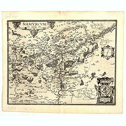
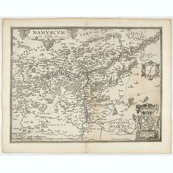
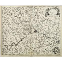
Namurcum Comitatus.
Prepared by Jacques Surhon in 1555. His manuscript map was for security reason not published. Only in 1579, when Antwerp was independent for a short time, Ortelius used a...
Place & Date: Antwerp, 1598
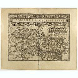
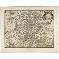
Leodiensis Diocesis Typus.
East to the top. Centered on Liege, including the southern part of Dutch Limburg. Prepared by Jan van Schille.Dare to go in Black. All early maps were printed in black an...
Place & Date: Antwerp, 1598
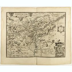
Namurcum Comitatus.
Prepared by Jacques Surhon in 1555. His manuscript map was, for security reasons not published. Only in 1579, when Antwerp was independent for a short time, Ortelius used...
Place & Date: Antwerp, 1598

Descriptio Galliae Belgicae.
A decorative miniature map of a section of ancient France, and that of Belgium. Features a nice strap-work title, shows rivers and settlements. From the Bertius atlas Tab...
- $100 / ≈ €88
Place & Date: Amsterdam, 1606

Hannonia.
An attractive miniature map of the Belgian, region of Hainaut, published by Petrus Bertius, in Amsterdam at the beginning of the seventeenth century. It features a small ...
Place & Date: Amsterdam, 1606

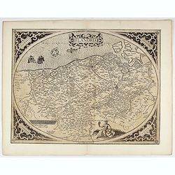
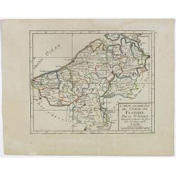
Flandria.
A lovely set of miniature map of Flanders. With an attractive strap-work title, and with detailed topography and information. Bertius (1565-1629) was a Flemish cartograph...
Place & Date: Amsterdam, 1606

Leodiensis Dioecesis.
A miniature map of the southern part of Belgium centered on Liege. The title cartouche on the lower left corner.First published in 1598 in his Caert-Thresoor, the plates ...
- $75 / ≈ €66
Place & Date: Amsterdam / Frankfurt, 1609

Domus Hansae Teutonicae / Sacri Romani Imperii. (Antwerp townhall)
From Ludovico Guicciardini.'s description of the Netherlands "Beschrijvinghe van alle de Nederlanden anderssins ghenoemt Neder-Duytslandt", published by Willem ...
- $100 / ≈ €88
Place & Date: Amsterdam, 1612
Flandria.
Very decorative, egg-shaped map. This is the last and very rare third state with the signature Theodorus Galle. The fortifications along the Scheldt River are added and t...
- $1000 / ≈ €880
Place & Date: Antwerp, after 1612
Namurcum Comitatus.
Prepared by Jacques Surhon in 1555. His manuscript map was for security reason not published. Only in 1579, when Antwerp was independent for a short time, Ortelius used a...
- $500 / ≈ €440
Place & Date: Antwerp, after 1612

Comitatus Hannonia.
Detailed map of the Belgium province Hainault or Henegouwen. Including the towns of Mons, Geraadsbergen, etc.Uncommon and decorative oval map in a rectangular frame, the ...
- $100 / ≈ €88
Place & Date: Amsterdam, 1616

Artesia descriptio.
Very rare. The map is dated 1624 which is unknown to Van der Krogt. Très rare, Van der Krogt ne signale pas cette édition de 1624, qui est postérieure à la dernières...
Place & Date: Amsterdam, 1624

Scaldis Antverpia - Locorum Insignium ac viae triumphalis qua ser.mus princeps, Ferdinandus Austriacus, Hispaniar, Infans. etc. Antverpiam est ingressus, designatio . . .
Bird's-eye view of the city of Antwerp and the River Schelde, numbered (1-59 ) with important sites along the entry of the Cardinal Infant Ferdinand of Austria into Antwe...
- $2000 / ≈ €1761
Place & Date: Antwerp, 1635-1641
Nobilis Hannoniae Comitatus Descrip.
Fine map of Hannonia (Hainaut), with ornate cartouches, two coats of arms, etc. Showing the cities of Charleroi, Mons, Ath, Tournay, Valenciennes, Maubeuge, etc. in Belgi...
- $600 / ≈ €528
Place & Date: Antwerp, 1612-1641
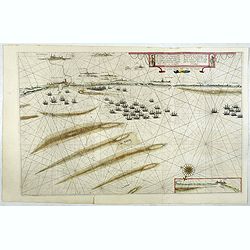
Afbeeldinge vande vermaerde seehaven .. Duynkerken..
Blaeu's map of the coast of the French coast from Duinkerk till Waldamme. In an inset, lower right the continuation till Calais. Many ships offshore Duinkerk, with soundi...
- $500 / ≈ €440
Place & Date: Amsterdam, 1645

Flandria et Zeelandia Comitatus.
Includes Flanders and Zeeland. The map originally engraved in 1641 for Sanderus 'Flandria Illustrata', was used several times in Blaeu's atlases.More about maps by Willem...
- $250 / ≈ €220
Place & Date: Amsterdam, 1645

Antverpia, Gallis Anvers. Vernacule Antwerpen.
Detailed plan of the city of Antwerp with extensive key to principal buildings. Lower left title cartouche with two coats of arms and Mercurius.
Place & Date: Amsterdam, 1649

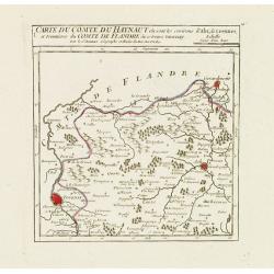
Carte du Comté de Flandre. . .
Decorative map of Flanders from Plans, et Profils des principales villes.. by Ch. De Beaulieu. Etched by mr. Romeijn de Hooghe.
- $80 / ≈ €70
Place & Date: Paris, 1668

Comitatus Flandriae Tabula, In Lucem Edita A Frederico De Wit.
Double page map of Flanders, the whole Belgian region northwest of Brussels, confined by Antwerp, Brussels, valenciennes, Arras, St. Omer and the Channel. Title heading a...
- $100 / ≈ €88
Place & Date: Amsterdam, 1680

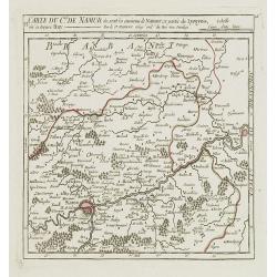
Comitatus Namurci Tabula in Lucem. . .
Centered on Namen, with decorative title cartouche upper right.
Place & Date: Amsterdam, 1680
Comitatus Namurci Emendata Delineatio, Nuperrimè in lucem edita, per Nicolaum Visscher.
Detailed engraved map of the province of Namur (Namen), showing cities including Charleroi and Dinant., towns, rivers and lakes. Decorative cartouche with putti. Explanat...
Place & Date: Amsterdam, 1684

Le Comté de Flandre par P. Placide Augustin. . .
Detailed map of Flanders prepared by P. Placide Augustin, with fine title cartouche and dedication to "Monseigneur Le Marquis de Torcy, Secretaire d'État" in u...
- $350 / ≈ €308
Place & Date: Paris, 1690
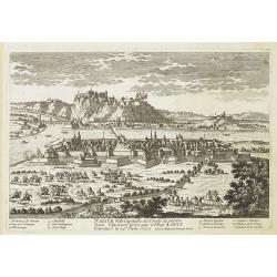
Namur Ville Capitale du Comté de même nom. Elle a este prise par le Roy LOUIS le Grand le 29e Juin 1692.
A very decorative and extremely rare town-view >of Namur, including a numbered key (1-12) in lower part. Engraved by Pierre-Alexandre Aveline. With "fait par Avel...
- $150 / ≈ €132
Place & Date: Paris, ca.1692

Furnes Ville du comté de Flandre à la France.
A very decorative and extremely raretown-viewof Veurne, including a numbered key (1-10) in lower part. Engraved by Pierre-Alexandre Aveline. With "fait par Aveline a...
- $220 / ≈ €194
Place & Date: Paris, ca.1692

Partie meridionale du Duché de Brabant comprend les Quartiers de Louvain et Brusselles. . .
Fine map of the Duchy of Belgium Brabant with a figurative armorial cartouche and small scale of miles. Boundaries outlined in hand color. The map is fully and richly eng...
- $250 / ≈ €220
Place & Date: Amsterdam, 1692

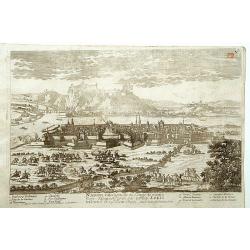
Charleroy place forte du Comte de Namur. . .
A very decorative and extremely rare town-view of Charleroi. Engraved by Pierre-Alexandre Aveline. With "Fait par Aveline avec privilege du Roy" in lower right ...
- $150 / ≈ €132
Place & Date: Paris, ca.1692
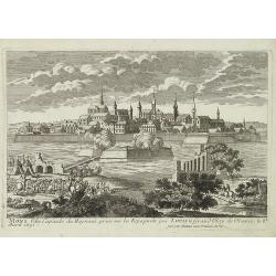
Mons ville capitale du Heynaut, prise sur les Espagnols par Louis le Grand Roy de France. . .
A very decorative and extremely raretown-viewof Mons. Engraved by Pierre-Alexandre Aveline. With "fait par Aveline avec privilege du Roy" in lower right margin....
- $150 / ≈ €132
Place & Date: Paris, ca.1692
Namur.
A very RARE panoramic of the city of Namur, with a numbered legend in both lower corners.The plate is numbered in red pencil in upper right corner.Engraved by Pierre Avel...
- $150 / ≈ €132
Place & Date: Paris, 1690-1720
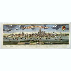
Antwerpen.
Panoramic town-view of Antwerp. With a numbered key (1-44) in lower part. Text in German.
- $2500 / ≈ €2201
Place & Date: Augsbourg, 1729
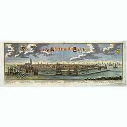
Ostende in Flandern.
Panoramic of Oostende. With a numbered key (1-11) in lower part. Text in German.Learn about the Ostend Trading Company or ‘Generale Keijserlijche Indische compagnie�...
- $2500 / ≈ €2201
Place & Date: Augsbourg, 1729

Plan of ye Battle of Wynendale between ye Troops of ye Allies commanded by Major Gen. Webb & those of France under Count de La Motte Sept. 28 1708.
An interesting copper engraved battle plan of Pinedale during the War of the Spanish Succession, showing the position of General Webb's troops in order to protect an alli...
Place & Date: London, 1743

Plan of the Investiture of Ostend Surrenderd, 6 July, 1706
An interesting copper engraved plan of the Fortification of Doway in Flanders, with an attractive rococo cartouche, showing an overview of the battlefield and surrounding...
Place & Date: London, 1743
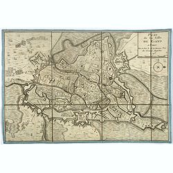
Plan de la ville de Gand. Paris, Sr. Le Rouge, 1745.
Town-plan of Ghent with its citadel, published in 1745, the year when the city was taken by the French during the War of Austrian Succession. The north is located to the ...
- $380 / ≈ €335
Place & Date: Paris, 1745

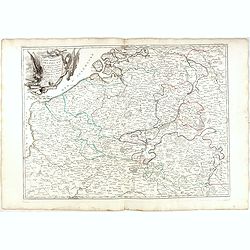
Carte Des Pays Bas Catholiques Dressée. . .
Topographically detailed map that extends from Paris to Metz and north into Holland. Details include roads and scores of villages. Two decorative cartouches: one with fig...
- $150 / ≈ €132
Place & Date: Amsterdam, c. 1745
Carte du Comté de Flandre, Dressée sur differens. . .
Large, detailed map of the Flanders including the French Flemish-speaking area. Shows illustrated topography with notations about towns, roads, fortresses, abbeys, monast...
- $100 / ≈ €88
Place & Date: Amsterdam, c. 1745

VI. Carte du Duché de Limbourg où sont les environs de Limbourg.
Attractive small map showing part of the Wallon region, centered on Limburg. Dated 1748. From Atlas Portatif Universel, by Robert de Vaugondy.Page 15f outside border top ...
- $45 / ≈ €40
Place & Date: Paris, 1748
![[IV.] Carte du Brabant où se trouvét la Mairie de Santhoven.. Ryen.](/uploads/cache/24684-250x250.jpg)
[IV.] Carte du Brabant où se trouvét la Mairie de Santhoven.. Ryen.
Nice small map encompassing an area which straddles the border between Belgium and the Netherlands.Showing Antwerp in the central lower part. From Atlas Portatif Universe...
Place & Date: Paris, later than 1748
Selling price: $70
Sold in 2008

V. Carte du Brabant ou se trouvét les Mair.s d'Herentals.. Hochstraten.
Nice small map illustrating the northeastern part of the Flemish region. Centered on Turnhout.From Atlas Portatif Universel, by Robert de Vaugondy. Unrecorded state with ...
- $50 / ≈ €44
Place & Date: Paris, later than 1748
VI. Carte du C.té de Namur où sont les environs de Namur.. Huy.
Attractive small map illustrating part of the Walloon Region, between Namur and Huy. From Atlas Portatif Universel, by Robert de Vaugondy.Unrecorded state with erased dat...
- $50 / ≈ €44
Place & Date: Paris, after 1748
![[X.] Carte du Brabant où sont les environs de Tillemont, de Judoigne, de Gemblours &c.](/uploads/cache/24690-250x250.jpg)
[X.] Carte du Brabant où sont les environs de Tillemont, de Judoigne, de Gemblours &c.
Nice small map straddling the Flemish and the Walloon regions. Extending North to South from Tienen to Gembloux.From Atlas Portatif Universel, by Robert de Vaugondy. Unre...
- $30 / ≈ €26
Place & Date: Paris, later than 1748
I. Carte du Comté de Flandre où sont les env.s de l'Ecluse, d'Ardenburg.. &c.
Nice small map illustrating the southwestern most part of Zeeland. Centered on Sluis. Showing Aardenburg and Vlissingen. Dated 1768.From Atlas Portatif Universel, by Robe...
Place & Date: Paris, later than 1748
Selling price: $100
Sold in 2008

V. Carte des C.tes de Haynaut et de Namur. . .
Attractive small map illustrating part of the Walloon Region, centered on Charleroi. From Atlas Portatif Universel, by Robert de Vaugondy.Unrecorded state with erased dat...
- $30 / ≈ €26
Place & Date: Paris, after 1748

I. Carte du D.ché de Luxembourg ou sont les Frontieres du Namurois et du Lyegeois.
Charming small map representing part of the Walloon Region, delimited by the towns of Namur, Huy, Dinant and Ciney.From Atlas Portatif Universel, by Robert de Vaugondy. E...
Place & Date: Paris, later than 1749
![[IX.] Carte du Brabant ou sont les Mairies de Roo, de Nivelle, de Hulpen, et de Geneppe.](/uploads/cache/24689-250x250.jpg)
[IX.] Carte du Brabant ou sont les Mairies de Roo, de Nivelle, de Hulpen, et de Geneppe.
Nice small map straddling the Flemish and the Walloon regions. It shows Halle, Nivelles, La Hulpe, Overijse, Genappe, etc.From Atlas Portatif Universel, by Robert de Vaug...
Place & Date: Paris, later than 1749
![La ville et citadelle d'Anvers. [Antwerp]](/uploads/cache/39843-250x250.jpg)
La ville et citadelle d'Anvers. [Antwerp]
A town-plan of the fortified enclosure of Antwerp with its citadel, showing the extensions made between 1201 and 1701, when the fortifications were enlarged by Philippe V...
- $225 / ≈ €198
Place & Date: Paris, ca. 1750
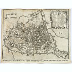
Ghent a large City and Castle in Flanders. . .
A very fine bird's-eye plan of the city and fortifications of Ghent and the surrounding countryside in Belgium. A decorative cartouche encloses a detailed key to the map ...
- $100 / ≈ €88
Place & Date: London, ca 1750
![Plan de Mons ville capitale du comté de Haynaut. [MONS]](/uploads/cache/39799-250x250.jpg)
Plan de Mons ville capitale du comté de Haynaut. [MONS]
Charming little plan of the city of Mons in Belgium, engraved by Inselin, with a lettered key (A-V) in lower right corner.
Place & Date: Paris, 1750
![[OSTENDE] A new and exact Plan of the city and port of Ostend.](/uploads/cache/39849-250x250.jpg)
[OSTENDE] A new and exact Plan of the city and port of Ostend.
Nice plan of the city of Ostend and Fort Philippe, engraved by R. Benning. In upper left corner "A map of part of Flanders shewing the country and sands about Ostend...
- $300 / ≈ €264
Place & Date: Paris, ca. 1750
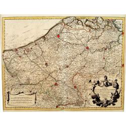
Partie meridionale des Pays Bas.. Cambrefis et Artois.
Finely and crisply engraved map of Belgium, including southern part of Netherlands and part of Germany.Venetian edition of Giles Didier Robert De Vaugondy's map from Atla...
- $100 / ≈ €88
Place & Date: Venice, 1776 - 1784

Il Paesi Bassi Austriaci, che comprendono parte delle Flandre, del Haynault, e del Brabante.
Uncommon map of Flanders and Brabant in present-day Belgium. Embellished with a nice title-cartouche. Engraved by G.Pitteri after G.Zuliani.From his Atlante Novissimo, il...
- $140 / ≈ €123
Place & Date: Venice, 1784

Partie meridionale des Pays Bas.. Cambrefis et Artois.
Finely and crisply engraved map of Belgium, including southern part of Netherlands and part of Germany.Venetian edition of Giles Didier Robert De Vaugondy's map from Atla...
Place & Date: Venice, 1776 - 1784

Post-Route von Brüssel nach Gent, Brügge, Ostende, nach Antwerpen und Bergen op Zoom. N°XXIII
Very rare post route maps map centered on Gent, and showing the postal routes in-between Oostende, Bruges, Gent, Brussels, Mechelen, Lier, Antwerp, Bergen op Zoom, etc. f...
- $250 / ≈ €220
Place & Date: Nürnberg, Weigel and Schneider, ca.1785

Des Hochstifts Luttich..
Uncommon map covering the area of Limburg in present day Belgium. Also including western borderline of the Dutch province of Limburg.
- $125 / ≈ €110
Place & Date: Vienna, 1791

Charleroy place forte du Comte de Namur pres de la Riviere de Sambre. . .
A very decorative and extremely rare town-view of Charleroi. Engraved by Pierre-Alexandre Aveline. With "fait par Aveline avec privilege du Roy" in lower margin...
- $150 / ≈ €132
Place & Date: Paris, ca.1792

I Paési Bassi Austriaci.
A rare and detailed map of Belgium by Pazzini, Carli (1707-1769) and Bartolomeo Borghi (1750-1821). Features decorative title cartouche. Included in "Atlante Geogra...
- $125 / ≈ €110
Place & Date: Siena, 1796

X. Carte du Comté de Namur où se trouvent les environs de Dinant.
Attractive small map showing an area straddling the border between France and Belgium.It shows Dinant, Ciney, and the fort of Charlemont, built by Charles V on the French...
- $30 / ≈ €26
Place & Date: Paris, 1799
I. Carte du Comté du Haynaut.. Tournay.
Attractive small map encompassing part of Hainaut, between Tournai and Ath. From Atlas Portatif Universel, by Robert de Vaugondy.Edited by : "Au dépôt de Géograph...
- $40 / ≈ €35
Place & Date: Paris, 1799

Département de Jemmape.
Map representing the area around Mons, with a short key list in the lower right corner.From Atlas de la Géographie de toutes les parties du monde .. Ouvrage destiné pou...
- $30 / ≈ €26
Place & Date: Paris, Prudhomme, Levrault, Debray, 1806

Département de la Dyle.
Map centered on Bruxelles with a short key list in the lower right corner. From Atlas de la Géographie de toutes les parties du monde .. Ouvrage destiné pour l'educatio...
- $40 / ≈ €35
Place & Date: Paris, Prudhomme, Levrault, Debray, 1806
![[Goose game board] Le 1914 Edition pochette.](/uploads/cache/47215-250x250.jpg)
[Goose game board] Le 1914 Edition pochette.
Goose game in the form of a folding map of north of France and Belgium, with part of England, Germany, Holland and Luxembourg.
- $450 / ≈ €396
Place & Date: Paris, 1914
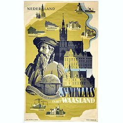
Sint Niklaas en het Waasland Gerardus Mercator Museum.
Poster showing a portrait of Gerard Mercator, set behind a globe and the town hall of St. Niklaas. Showing a map of the region containing pictorial vignets of Overmere, K...
- $500 / ≈ €440
Place & Date: Brussels, 1951