Browse Listings in Europe
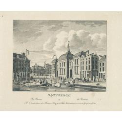
ROTTERDAM De beurs - La Bourse.
Decorative view of the exchange of Rotterdam. Printed by the master printer François Buffa of Amsterdam.
- $75 / ≈ €66
Place & Date: Amsterdam, 1860

ROTTERDAM Gezigt op de Societeit in het nieuwe. . .
Decorative view of the society of Rotterdam. Decorated with personages in typical dress watching a concert.
- $75 / ≈ €66
Place & Date: Amsterdam, 1860

Race Finnoise. Paysans du gouvernement d'Olonetz districts de Petrozavodsk et de Vytiagorsk.
Lithography on tinted grounds printed by Lemercier in Paris and published by Velten in St. Petersburg.
- $100 / ≈ €88
Place & Date: Paris, St. Petersburg, Carlsruhe, c.1860

Race Finnoise. = Paysans du gouvernement d'Olonetz districts de Petrozavodsk et de Vytiagorsk.
People in local dress from Petrozavodsk region in Russia. Lithography on tinted grounds printed by Lemercier in Paris and published by Velten in St. Petersburg.
- $150 / ≈ €132
Place & Date: Paris, St. Petersburg, Carlsruhe, c.1860
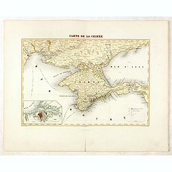
Carte de la Crimée / dressée par A. Vuillemin.
Attractive map of Crimea with inset plan of Sevastopol, prepared by Alexandre Aimé Vuillemin (1812-1886). A road system and the ferry lines are drawn in.Engraved by Jaco...
- $300 / ≈ €264
Place & Date: Paris, ca. 1860

Combat de Palestro.
Showing the battle of Palestro lithographed by E.S. Walter and printed by De Becquet and published by Rousselot in Paris.The lithograph is part of a series of prints publ...
- $100 / ≈ €88
Place & Date: Paris, ca. 1860
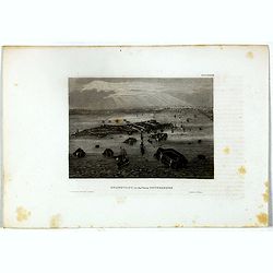
Kronstadt, in der ferne Petersburg.
Bird's eye view of Kronstadt, Russia's naval basis in front of Saint Petersburg. Original steel engraving published by Bibliographisches Institut Hildburghausen.
- $15 / ≈ €13
Place & Date: Hildburghausen, ca. 1860
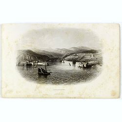
Sebastopol.
Steel engraving of the harbour at Sebastopol in the Ukraine published by James Virtue around 1860.
- $45 / ≈ €40
Place & Date: London, 1860
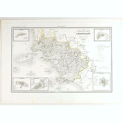
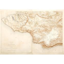
V. Compartimento Grossetano. . .
Very finely engraved and detailed map of Tuscany, centered on Grosseto. The island of Elba in left part.. In the corners insets of Sovana, Massa, Piombino, Orbetello and ...
- $200 / ≈ €176
Place & Date: Rome, 1860
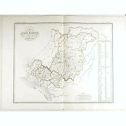
Carta degla Stati Estensi avanti il domino dei Romani Sotto Il governo dei Medesimi.
Very finely engraved and detailed map of the Duchy of Lucca before the dominion of the Romans under the rule of the same and in the Middle AgesWith a key on the right par...
- $200 / ≈ €176
Place & Date: Rome, 1860
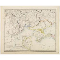
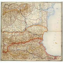
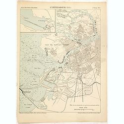
Russia in Europe Part VIII with index map.
Very detailed steel engraved map of the region north of the Black Sea, Podolia, Bessarabia, Kherson, Iekaterinoslav, Taurida, Krimea. Relief shown by hachures.The map is ...
- $150 / ≈ €132
Place & Date: London, Edward Stanford, 1864
Widok Krakowa od Podgonza.
Bird's-eye view of Krakow city, with underneath the names of thirteen important buildings. Lithographed by J.Brydak after a photo by W. Rzewuskriego. Published by Czasu W...
- $750 / ≈ €660
Place & Date: Krakow, ca. 1865
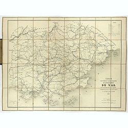
Carte routière et administrative du département du Var dressée sous l'administration et l'approbation de M. Montois, officier de la légion d'honneur, préfet , par J.B CHABET.
Folding-map of the Maritime Alps, and the Mediterranean coastline of Fréjus, Ramatuelle, St Tropez, Toulon. Engraved by Erhard, geographer and engraver (1821-1880) at th...
- $125 / ≈ €110
Place & Date: Paris, 1865

The Prince visiting the foundling hospital. / The Prince visiting the Metropolitan Archbishop.
Two engravings shown Albert Edward the Prince of Wales visiting Moscow from the Illustrated London News.
- $10 / ≈ €9
Place & Date: London, 1866
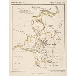
Gemeente Roermond.
From: J.Kuyper Gemeente-Atlas van Nederland naar officieele bronnen bewerkt. He was one of the most important of the Dutch atlas editors of the second half of the 19th ce...
- $90 / ≈ €79
Place & Date: Leeuwarden 1867
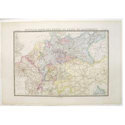
Nouvelle carte des routes de poste de l'Allemagne.
Large post road maps map of Germany, Poland, Austria, Franc, Switzerland, Austria and the Low Countries published by A. Logerot and engraved by C.Dyonnet.The mapsmakes di...
- $350 / ≈ €308
Place & Date: Paris, A. Logerot, c.1867

Carte géographique, physique et politique des royaumes d'Espagne et de Portugal indiquant les chemin fer en exploitations, ceux en cours d'éxécutions
Very large, highly detailed and uncommon map of Spain, Portugal and the northern coast of Africa. The map shows according to the title: rail roads, main interregional rou...
Place & Date: Paris, c.1867

Den Briel.
Attractive lithography showing a typical Dutch street scene of Den Briel in the middle of the 19th century, lithographed by A.C.Cramer after a painting by Cornelis Spring...
- $50 / ≈ €44
Place & Date: The Hague, 1869
Birds-eye view of the Straits of Kertch & Sea of Azoff.
Steel engraving of the harbour at Sebastopol and the Straits of Kertch and Sea of Azoff in the Ukraine published by James Virtue around 1860.Title in upper margin. With a...
- $75 / ≈ €66
Place & Date: London, 1870

Le plan Trochu.
Lithography showing a map of France with a caricature of General Trochu and other scenes imposed on it. Designed by the French caricaturist Evrard, Emile , with his initi...
- $800 / ≈ €704
Place & Date: Paris, 1871
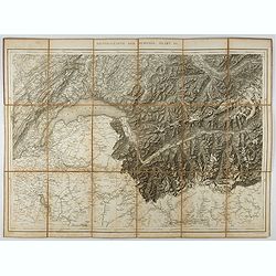
Generalkarte der Schweiz. Blatt III.
Folding map showing Leman lake. The map, engraved by Müllhaupt, is probably part of the 'Topographical Atlas of the Federal General Staff reduced under the direction of ...
- $75 / ≈ €66
Place & Date: Bern, 1873

Espagne et Portugal.
A decorative map of Spain and Portugal from Géographie Universelle, Atlas Migeon. With an engraving of the Alhambra in the lower right corner. Published by J. Migeon. Fr...
- $35 / ≈ €31
Place & Date: Paris, 1874
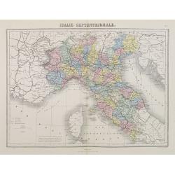
Italie Septentrionale.
A decorative map of northern Italy from Géographie Universelle, Atlas Migeon, published by J. Migeon.From one of the last decorative atlases published in the 19th centur...
- $25 / ≈ €22
Place & Date: Paris, 1874
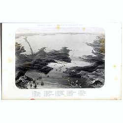
Plan général des environs de Sébastopol avec indication de la disposition générale de l'armée alliée au 24 octobre / 5 novembre 1854 et du mouvement du prince Gortchakow vers le mont Sapoune.
A very rare panoramic town-plan of the siege of Sebastopol. In lower margin : "Gravé au Dépôt topographique de la Guerre". From "Défense de Sébastopol...
Place & Date: Saint-Pétersbourg / Paris, 1863-1874
Selling price: $750
Sold in 2014
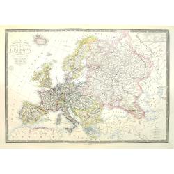
Nouvelle carte physique et politique de l'Europe. Les limites d'états.
Very large, uncommon updated version of the map of Europe prepared by H. Brué and updated by A. Vuillemin. In lower margin "Nouvelle edition" and a date (1875)...
Place & Date: Paris, 1875
(Untitled map of western shores of the Black Sea, with Bulgaria, Roumenia.)
Untitled map of western shores of the Black Sea, with Bulgaria, Roumenia. The map has elaborate floral borders. Prepared by Josef Schlacher in Vienna and published by K.K...
- $150 / ≈ €132
Place & Date: Vienna, K.K. Militär Geografisches Institut, 1875
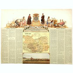
Provincia de Ciudad-Real.
Chromolithography published in "Atlas geográfico histórico de las Provincias de España". Map made by J. Reinoso, Dedicated to Excmo. Sr. Dn. Baldomero Espart...
- $120 / ≈ €106
Place & Date: Madrid, c. 1875

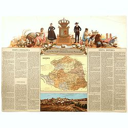
Provincia de Santander.
Chromolithography published in "Atlas geográfico histórico de las Provincias de España". Map engraved by J. Reinoso, Dedicated to Excmo. Sr. Duque de Santona...
- $120 / ≈ €106
Place & Date: Madrid, c. 1875
Provincia de Caceres.
Chromolithography published in "Atlas geográfico histórico de las Provincias de España". Map made by M. Vierge, Dedicated to Excmo. Sr. Dn. Cipriano Segundo ...
- $120 / ≈ €106
Place & Date: Madrid, c. 1875

Provincia de Badajoz.
Chromolithography published in "Atlas geográfico histórico de las Provincias de España". Map engraved by M. Vierge, Dedicated to Ilmo. Sr. Dn. Vicente Barran...
- $120 / ≈ €106
Place & Date: Madrid, c. 1875

Provincia de Albacete.
Chromolithography published in "Atlas geográfico histórico de las Provincias de España". Map made by M. Vierge, Dedicated to Ilmo. Sr. Dn. Vicente Barrantes....
- $60 / ≈ €53
Place & Date: Madrid, c. 1875
![[Schwarzes Meer] Nr 1](/uploads/cache/37946-250x250.jpg)
[Schwarzes Meer] Nr 1
Uncommon map of the Black Sea and Crimea. In lower part a scale. Prepared by Friedrich Handtke (1815-1879). Map set in a decorative border.
- $120 / ≈ €106
Place & Date: Glogau, Leipzig, 1877

Plan de Paris A l'Echelle de 2 Millim. pour 2.5 Metres . . . Indiquant les Nouveaux percements et les changements de mons de Voies publiques Avec Plans Supplmentaries Pour Les Bois De Boulogne et De Vicennes . . .
Magnificent map of the urban redevelopments planned for Paris at the end of the 19th century. The map has been updated, with insets showing supplemental plans for the Boi...
- $600 / ≈ €528
Place & Date: Paris, 1878

Angers 1878.
Large bird's-eye view of Angers after Mollay and lithographed by Muller.
- $250 / ≈ €220
Place & Date: Paris, Lemercier, ca. 1878

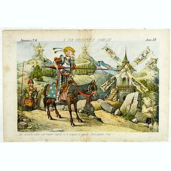
Miss Cora Europea. Papagallo No. 35. Anno VI.
Miss Europa taming the lion (Russia) with other nations shown as animals. Design by Augusto Grossi. Taken from the Italian satirical newspaper Il Papagallo, a satirical m...
Place & Date: Bologne, 1878
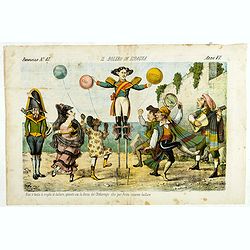
Il bolero in Ispagnia. Papagallo No. 42. Anno VI.
About Spanish expansion, with balloons symbolizing Cuba, Havana, Cortes. Taken from the Italian satirical newspaper Il Papagallo, a satirical magazine founded in January ...
Place & Date: Bologne, 1878
Il Don Cihsciotte a complici. Papagallo No. 48. Anno VI.
Taken from the Italian satirical newspaper Il Papagallo, a satirical magazine founded in January 1873 by Augusto Grossi (1835-1919), which specialized in color-printed ca...
Place & Date: Bologne, 1878
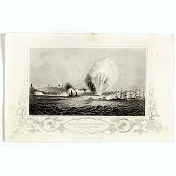
Bombardment of Odessa by the English and French April 22 1854, explosion on the imperial mole . . .
Scene from the Crimea war, showing a bombardment of Odessa, 22nd April 1854 (during Crimean War, 1853-56), by English and French forces, explosion imperial mole (breakwat...
- $30 / ≈ €26
Place & Date: London, ca. 1879

Sint Catharinakerk te Eindhoven
Uncommon print of St.Catharina church of Eindhoven, built by the well-known architect P.Cuijpers. Published in Katholieke Illustratie .
- $85 / ≈ €75
Place & Date: 'sHertogenbosch, 1880
![Sint-Catharinakerk te Eindhoven [with plan]](/uploads/cache/28813-250x250.jpg)
Sint-Catharinakerk te Eindhoven [with plan]
Uncommon wood engraved print of St.Catharina church in Eindhoven, built by the well-known architect P.Cuijpers. Published in Kunstkronijk. This wood engraving is similar ...
- $85 / ≈ €75
Place & Date: Amsterdam, c.1880

The attempt on the Czar's life: the Soltykoff dorway of the Winter Palace . . .
A panorama of the Winter Palace published in the Illustrated London News of 1880.
- $20 / ≈ €18
Place & Date: London, 28 February, 1880

The attempt on the Czar's life: The Winter Palace, St Petersburg.
A panorama of the Winter Palace with an attempt on the Czar's life published in the Illustrated London News of 28 February, 1880.
- $15 / ≈ €13
Place & Date: London, 28 February, 1880

The attempt on the Czar's life: The Grand Ball-Room . . .
A panorama of the Winter Palace with an attempt on the Czar's life published in the Illustrated London News of 28 February, 1880.
- $15 / ≈ €13
Place & Date: London, 28 February, 1880

Porte Ste Barbe.
View of the gate of St. Barbe. Title in Russian and French.
- $50 / ≈ €44
Place & Date: Russia, ca. 1880

Bataille de la Moskova.
Etching of a battle in which Napoleon's army fought the Russian army of general Kutuzov on 7 September 1812.Etched by Auguste II. Boulard (1852–1927) after a painting b...
- $50 / ≈ €44
Place & Date: Paris, 1880
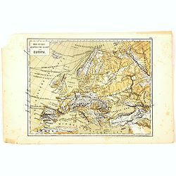
Oro-Hydrographische Kaart van Europa.
One of the earliest thematic maps of Europe published in the Netherlands from "Atlas der natuurkundige aardrijkskunde. . .". prepared by Nicolaas Wilhelmus Post...
- $35 / ≈ €31
Place & Date: Amsterdam, C.L. Brinkman, 1883
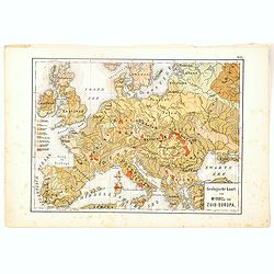
Geologische Kaart van Middel- en Zuid-Europa.
One of the earliest thematic maps published in the Netherlands from "Atlas der natuurkundige aardrijkskunde. . .". prepared by Nicolaas Wilhelmus Posthumus. Wit...
- $35 / ≈ €31
Place & Date: Amsterdam, C.L. Brinkman, 1883

De luciferfabriek van de Heeren Mennen en Krunen te Eindhoven.
Wood engraving published in "Katholieke Illustratie", showing the match factories of Mennnen en Krunen in Eindhoven. Founded in 1870 by banker Christiaan Mennen...
- $40 / ≈ €35
Place & Date: s-Hertogenbosch, H.Bogaerts, ca. 1885

Cronstadt et St. Petersbourg.
Detailed plan of the port and city of St. Petersburg including Kotlin Island and the fortified town of Kronstadt.
- $35 / ≈ €31
Place & Date: Paris, 1888
St. Pétersbourg (1888).
Map of St. Petersburg from a French multi volume atlas published by the Ministere des Travaux Publics (Ministry of Civil Engineering), called "Atlas des ports étran...
- $120 / ≈ €106
Place & Date: ?Paris, Imprimerie Nationale 1884-1889

Topographie historique du vieux Paris / Plan de restitution Feuille V.
Copper engraved plan centered on Louvre by Jean-Joseph Sulpis (1826–1911) after a model by Adolphe Berty. Plate 5 from "Topographie historique du vieux Paris"...
Place & Date: Paris, 1866-1897

Topographie historique du vieux Paris / Plan de restitution Feuille V bis.
Copper engraved plan centered on gardens of the Louvre by Jean-Joseph Sulpis (1826–1911) after a model by Adolphe Berty. Plate 5bis from "Topographie historique du...
Place & Date: Paris, 1866-1897

Britain's Empire on the Sea. Dedicated to Captain the Right Honourable Lord Charles Beresford...
A very decorative and large chromolithographed plate showing all the effective strength of the British navy with the name and class of each ship shown beneath, except for...
- $750 / ≈ €660
Place & Date: Portsea, ca. 1897

The Royal Naval review at Spithead, June 26th, 1897. In Honour of Her Majesty Queen Victoria's Diamond Jubilee.
A very decorative and large chromolithographed plate showing a line up of international vessels at Spithead, June 26th, 1897 In Honour of her Majesty Queen Victoria'a Dia...
- $750 / ≈ €660
Place & Date: Portsea, ca. 1897
![[Map of the Alps].](/uploads/cache/46164-250x250.jpg)
[Map of the Alps].
Alexey Afinogenovich Ilyin was a lieutenant general and cartographer (1832-1889). In 1856, after graduating from the Academy of the General Staff, he was at the military ...
- $45 / ≈ €40
Place & Date: St. Petersburg, 1899
![[Lake Garda and its surroundings].](/uploads/cache/46166-250x250.jpg)
[Lake Garda and its surroundings].
Alexey Afinogenovich Ilyin was a lieutenant general and cartographer (1832-1889). In 1856, after graduating from the Academy of the General Staff, he was at the military ...
- $100 / ≈ €88
Place & Date: St. Petersburg, 1899
![[France - The Netherlands - Belgium].](/uploads/cache/46168-250x250.jpg)
[France - The Netherlands - Belgium].
Alexey Afinogenovich Ilyin was a lieutenant general and cartographer (1832-1889). In 1856, after graduating from the Academy of the General Staff, he was at the military ...
- $50 / ≈ €44
Place & Date: St. Petersburg, 1899
![[The United Kingdom - Sweden, Norway, Denmark].](/uploads/cache/46169-250x250.jpg)
[The United Kingdom - Sweden, Norway, Denmark].
Alexey Afinogenovich Ilyin was a lieutenant general and cartographer (1832-1889). In 1856, after graduating from the Academy of the General Staff, he was at the military ...
- $50 / ≈ €44
Place & Date: St. Petersburg, 1899
![[Oxford Canal from Oxford to Coventry].](/uploads/cache/37232-250x250.jpg)
[Oxford Canal from Oxford to Coventry].
Manuscript map covering the Oxford Canal. Orientated East to the North. The Oxford Canal is a 78-mile-long (126 km) narrow canal in central England linking Oxford with Co...
- $140 / ≈ €123
Place & Date: ca. 1900

Léon Tolstoy.
Etching by Gustaf Frank after a painting of Ilya Repin (1887). Gustav Frank (1859-1923) attended school in Vlasim, where he learned to draw from Cenka Schneider. Then he ...
- $50 / ≈ €44
Place & Date: Vienna, 1900
![[map printed on a tissue] The British remedy for coughs and colds. Owbridge's lung tonic.](/uploads/cache/40288-250x250.jpg)
[map printed on a tissue] The British remedy for coughs and colds. Owbridge's lung tonic.
Handkerchief showing a map of Europe and part of Asia continent printed on a tissue. OWBRIDGE’S LUNG TONIC, THE BRITISH REMEDY FOR COUGHS AND COLDS.Walter Thomas Owbrid...
- $400 / ≈ €352
Place & Date: London, ca. 1900
![[Les anciennes provinces Françaises à la ville de Saint Denis].](/uploads/cache/41681-250x250.jpg)
[Les anciennes provinces Françaises à la ville de Saint Denis].
Nine small chromolithography's trade cards for Ville de Saint Denis, each with French regions and places, with description in French on each verso.Cards of the regions : ...
Place & Date: Paris, circa 1900
![[Les anciennes provinces Françaises à la ville de Saint Denis].](/uploads/cache/41683-250x250.jpg)
[Les anciennes provinces Françaises à la ville de Saint Denis].
Nine small chromolithography trade cards for Ville de Saint-Denis, each with French regions and places, with description in French on each verso.Cards of the regions: Lor...
Place & Date: Paris, circa 1900
![[Les anciennes provinces Françaises à la ville de Saint Denis].](/uploads/cache/41684-250x250.jpg)
[Les anciennes provinces Françaises à la ville de Saint Denis].
Nine small chromolithography's trade cards for Ville de Saint Denis, each with French regions and places, with description in French on each verso.Cards of the regions : ...
Place & Date: Paris, circa 1900
![[Map of Grodno gubernia.]](/uploads/cache/81813-250x250.jpg)
[Map of Grodno gubernia.]
Карта Гродненско&...
- $450 / ≈ €396
Place & Date: Sankt Peterburg, 1850-1900

Carte routière de France de Dion Bouton spéciale pour automobiles
Highly decorative folding wall map of France in a scale of 1 : 800 000. In the upper left hand corner an inset plan of Paris, upper right Algeria and lower right map of C...
- $1500 / ≈ €1321
Place & Date: Paris, J. Barreau, 1900

Carte nationale des routes de la France.
Map of the national roads in France, engraved and published by Regnier et Dourdet. Four inset maps of which three shows the three largest cities in France and one shows C...
- $75 / ≈ €66
Place & Date: Paris, ca. 1900

Plan des paroisses de Paris avec la distinction des parties éparses qui en dépendent dressé... par J. Junié, Ingén. Géogr. De Monseigneur l'Archeveque et géomètre des Eaux et forêts de ...
Large wall map size plan of Paris in 4 separate sheets, if joined forming a plan of Paris of 93 x 60cm. This plan is a 1904 version of a manuscript plan drawn in 1786 by ...
Place & Date: Paris, Service des Travaux historiques de la Ville de Paris, 1904
![Karta Evropeiskoi Rossii i Sibirii na 4 listakh [ Map of European Russia and Siberia in 4 sheets compiled and based on the most advanced statistical and geographical information.]](/uploads/cache/image-250x250.png)
Karta Evropeiskoi Rossii i Sibirii na 4 listakh [ Map of European Russia and Siberia in 4 sheets compiled and based on the most advanced statistical and geographical information.]
A fine large map showing Eastern Europe from Stockholm to Constantinople, with Russia eastward from Perm and south to the Caucasus and Iran. With indications of judicial ...
- $750 / ≈ €660
Place & Date: Saint Petersburg, 1908
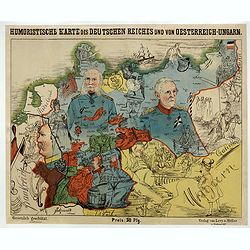
Humoristische Karte von Europa im Jahre 1914.
A satirical map of Europe with a title in German that marks the outbreak of the First World War, probably conceived between August and October 1914. Lehmann-Dumont was no...
Place & Date: Dresde, Leutert & Schneidewind, ca. 1914
![[Goose game board] Le 1914 Edition pochette.](/uploads/cache/47215-250x250.jpg)
[Goose game board] Le 1914 Edition pochette.
Goose game in the form of a folding map of north of France and Belgium, with part of England, Germany, Holland and Luxembourg.
- $450 / ≈ €396
Place & Date: Paris, 1914

A very early large London Underground enamel station sign for Westerminster Station
This large enamel sign can be dated between 1908 and 1915, when the bull’s-eye design, a solid red disk with a horizontal bar containing the text, was adopted by all th...
- $18750 / ≈ €16509
Place & Date: London, ca. 1908-1915
![[Map of Turkey in Ottoman script]](/uploads/cache/40765-250x250.jpg)
[Map of Turkey in Ottoman script]
Map of Turkey, including Cyprus, with text in Ottoman script. In the bottom a color key to the different regions. Published by Elbemühl Graphische Industrie in Vienna (f...
Place & Date: Vienna, ca. 1915
![[2 maps] Das Europa der Zukunft... / Das heutige Europa…[The Europe of the Future / The Europe of Today]](/uploads/cache/48735-250x250.jpg)
[2 maps] Das Europa der Zukunft... / Das heutige Europa…[The Europe of the Future / The Europe of Today]
A pair of very scarce WWI German maps highlighting Europe as it currently was, and Europe as it may become. The maps were produced as part of an 8 page booklet produced b...
- $2750 / ≈ €2421
Place & Date: Paris, 1917
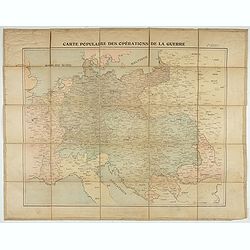
Carte populaire des opérations de la guerre. 2ème édition.
Folding map. War Operations Map showing a part of Europe, published by Epinal.
- $150 / ≈ €132
Place & Date: Paris, ca. 1919
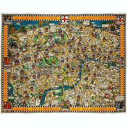
The Wonderground Map of London.
A large and pictorially striking 'Wonderland' advertising poster on behalf of the London Underground, published in the late 1920s. The poster was very popular, and ran fo...
- $4000 / ≈ €3522
Place & Date: London, ca 1927

Cesu un apkartnes vadonis ar Cesu pilsetas planu. . .
Uncommon and detailed plan of Cesis and its direct surroundings. Cesis is a town in northeastern Latvia, built in the 13th century and one of the best-preserved medieval ...
- $550 / ≈ €484
Place & Date: Cesu, 1928

Femme de Barèges (106, La Gascogne).
Plate published in "Les costumes régionaux de France" with illustrations by Gratiane de Gardilanne (painter and designer) and Elisabeth Whitney Moffat.Costume ...
- $75 / ≈ €66
Place & Date: Paris, Editions du Pégase, 1929

Laitière Bordelaise, d'après de Gallard (110, La Guyenne).
Plate published in "Les costumes régionaux de France" with illustrations by Gratiane de Gardilanne (painter and designer) and Elisabeth Whitney Moffat.Costume ...
- $75 / ≈ €66
Place & Date: Paris, Editions du Pégase, 1929
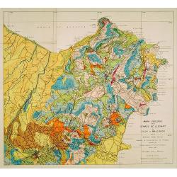
Mapa geologic de les serres de Llevant de l'illa de Mallorca.
Geological map showing part of the island Mallorca Manacor, Son Severa, Capdepera.. After a design by D.Ferrá. Dibuxá, in lower right corner: D.Ferrà. Dibuxá.Provenan...
- $150 / ≈ €132
Place & Date: Palma, 1932