Browse Listings in Europe

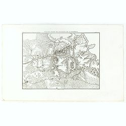
Eglise des saintes femmes.
A view of a church, the 5 of September 1839. Figures are lithographed by Raffet. Plate taken from the first illustrated account of Russian architecture. This publication ...
Place & Date: Paris, 1844

Nikolskoï paroisse entre les villes de Soudogda et Mouroum.
A view of an old church. Figures are lithographed by Raffet. Plate taken from the first illustrated account of Russian architecture. This publication was the project of C...
- $150 / ≈ €132
Place & Date: Paris, 1844

Vue du côté méridional.
A view of an old village. Figures are lithographed by Raffet. Plate taken from the first illustrated account of Russian architecture. This publication was the project of ...
- $150 / ≈ €132
Place & Date: Paris, 1844

ÉGLISE SAINT OUEN, A ROUEN. Dessiné d'après nature par Chapuy. Lith. par Deroy.
Original lithograph of Saint Ouen cathedral, situated in Rouen. Lithographed by Deroy after a design by Chapuy and printed in Paris by Lemercier, Bernard Cie.
- $125 / ≈ €110
Place & Date: Paris, 1844

FACADE DE LA CATHÉDRALE A CHARTRES. Dessiné d'après nature par Chapuy. Lith. par Deroy.
Original lithograph of Chartres Cathedral's facade. Lithographed by Deroy after a design by Chapuy and printed in Paris by Lemercier, Bernard Cie.
- $125 / ≈ €110
Place & Date: Paris, 1844

INTERIEUR DE L'EGLISE SAINT OUEN A ROUEN. Dessiné d'après nature par Chapuy. Lith. Par Arnout. Fig par Bayot.
Original lithograph of the inside of Saint Ouen chruch, situated in Rouen. Lithographed by Arnout and Adolphe-Jean-Baptist Bayot (Alessandria 1810 - 1866) after a design ...
- $50 / ≈ €44
Place & Date: Paris, 1844

ÉGLISE St. VINCENT A ROUEN. Dessiné d'après nature par Chapuy. Lith. par Monthelier. Fig. par Bayot.
Original lithograph of St Vincent cathedral, situated in Rouen. Lithographed by Jules Monthelier (1801-1883) and Adolphe-Jean-Baptist Bayot (Alessandria 1810 - 1866) afte...
- $80 / ≈ €70
Place & Date: Paris, 1844

TOMBEAU DU DUC DE BREZE, DANS LA CATHEDRALE DE ROUEN. Dessiné d'après nature par Chapuy. Lith. par Monthelier. Fig. par Bayot.
Original lithography of the tomb of the duke of Brézé, in the cathedral of Rouen. Lithographed by Jules Monthelier (1801-1883) and Adolphe-Jean-Baptist Bayot (Alessandr...
- $50 / ≈ €44
Place & Date: Paris, 1844

INTERIEUR DE LA CATHEDRALE A CHARTRES. Dessiné d'après nature par Chapuy. Lith. Par Bachelier.
Original lithograph of the inside of the cathedral situated in Chartres. Lithographed by Bachelier after a design by Chapuy and printed in Paris by Lemercier, Bernard Cie...
- $50 / ≈ €44
Place & Date: Paris, 1844

PALAIS DE JUSTICE A ROUEN. Dessiné d'après nature par Chapuy. Lith. par Rouargue.
Original lithograph of the courthouse of justice in Rouen. Lithographed by Rouargue after a design by Chapuy and printed in Paris by Lemercier, Bernard Cie.
- $150 / ≈ €132
Place & Date: Paris, 1844

ARC DE TRIOMPHE A ORANGE. Dessiné d'après nature par Guesdon. Lith. par Ad. Cuvellier. Fig. par Bayot.
Original lithograph of the Triumph Arc of Orange. Lithographed by A. Cuvillier and Adolphe-Jean-Baptist Bayot (Alessandria 1810 - 1866) after a design by Chapuy and print...
- $100 / ≈ €88
Place & Date: Paris, 1844

PORTAIL SEPTENTRIONAL DE LA CATHÉDRALE A CHARTRES. Dessiné d'après nature par Monthelier. Lith. par Monthelier.fig. par Bayot.
Original lithograph of the northern portal of Chartres cathedral. Lithographed by Jules Monthelier (1801-1883) and Adolphe-Jean-Baptist Bayot (Alessandria 1810 - 1866) af...
- $75 / ≈ €66
Place & Date: Paris, 1844

COMMERCY, Vue prise de la Garenne - Chemins de fer de l'Est. Dessiné d'après nat. et Lith. par A.Maugendre.
Original lithograph eye-bird view of Commercy, as seen from La Garenne. Lithographed by Jules Monthelier (1801-1883) and Adolphe-Jean-Baptist Bayot (Alessandria 1810 - 18...
- $110 / ≈ €97
Place & Date: Paris, 1844

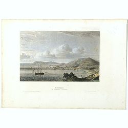
The church of Vasili Blagennoi Moscow.
Steel engraving of St. Basil's Cathedral in Moscow, after a design by Alfred Gomersal Vickers (1810-1837) engraved by James Harfield Kernot (1802-1858).
- $20 / ≈ €18
Place & Date: London, 1844
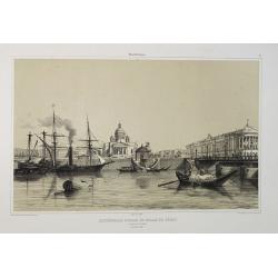
Cathédrale d'Isaac et Palais du Sénat. Vue prise de la Néva. (17 juillet 1839).
A view from the port of the Isaac Cathedral and the Senat Palace in Saint Petersburg on July 17 1839. Plate taken from the first illustrated account of Russian architectu...
Place & Date: Paris, 1845
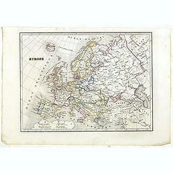
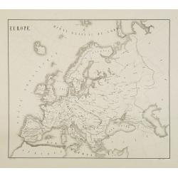
Europe.
Detailed Europe map, prepared by Charles V. Monin (fl.1830-1880) a French cartographer of Caen and Paris. Published in Atlas Universel de Géographie Ancienne &c Mode...
- $50 / ≈ €44
Place & Date: Paris, 1845

Hollande et Belgique.
Detailed Holland and Belgium map, prepared by Charles V. Monin (fl.1830-1880) a French cartographer of Caen and Paris. Published in Atlas Universel de Géographie Ancienn...
- $50 / ≈ €44
Place & Date: Paris, 1845

Iles Britanniques.
Detailed British Islands map, prepared by Charles V. Monin (fl.1830-1880) a French cartographer of Caen and Paris. Published in Atlas Universel de Géographie Ancienne &a...
- $25 / ≈ €22
Place & Date: Paris, 1845

Prusse.
Detailed map of Prussia, prepared by Charles V. Monin (fl.1830-1880) a French cartographer of Caen and Paris. Published in Atlas Universel de Géographie Ancienne &c ...
- $40 / ≈ €35
Place & Date: Paris, 1845

Empire d'Autriche.
Detailed map of Austria, prepared by Charles V. Monin (fl.1830-1880) a French cartographer of Caen and Paris. Published in Atlas Universel de Géographie Ancienne &c ...
- $25 / ≈ €22
Place & Date: Paris, 1845
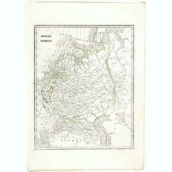
Russie d'Europe.
Detailed map of European Russia, prepared by Charles V. Monin (fl.1830-1880) a French cartographer of Caen and Paris. Published in Atlas Universel de Géographie Ancienne...
- $25 / ≈ €22
Place & Date: Paris, 1845
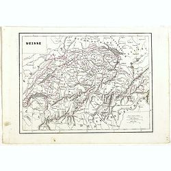
Suisse.
Detailed map of Switzerland, prepared by Charles V. Monin (fl.1830-1880) a French cartographer of Caen and Paris. Published in Atlas Universel de Géographie Ancienne &am...
- $45 / ≈ €40
Place & Date: Paris, 1845

Suède, Norvège et Danemark.
Detailed map of Sweden, Norway and Denmark, prepared by Charles V. Monin (fl.1830-1880) a French cartographer of Caen and Paris. Published in Atlas Universel de Géograph...
- $35 / ≈ €31
Place & Date: Paris, 1845

La Gaule sous l'Empire Romain.
Detailed map of France, prepared by Charles V. Monin (fl.1830-1880) a French cartographer of Caen and Paris. Published in Atlas Universel de Géographie Ancienne &c M...
- $25 / ≈ €22
Place & Date: Paris, 1845

Russia in Europe.
From S. Augustus Mitchell’s "A New Universal Atlas". Philadelphia. Lithographic transfer from engraved plate. A fine map of Russia in Europe from the mid-nine...
- $80 / ≈ €70
Place & Date: Philadelphia, c.1846
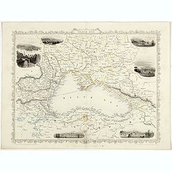
![[Untitled map of Black Sea].](/uploads/cache/37349-250x250.jpg)
[Untitled map of Black Sea].
Very detailed and rare map of Black Sea region. The map has elaborate floral borders. Prepared by Joseph Scheda in Vienna.
- $200 / ≈ €176
Place & Date: Vienna, 1845-1847

Nouveau plan illustré de la ville de Paris . . .
Fine plan of Paris, engraved by Taylor. "With the complete system of its fortifications and strong detached". Adorned with many vignettes engraved with monument...
- $900 / ≈ €792
Place & Date: Paris, 1847
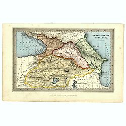
Armenia major, Iberia etc. by J.Archer.
Early Missionary map of Armenia from the "Atlas of educational maps for the use of schoolmasters" (1847), published by SPCK - the Society for Promoting Christia...
- $150 / ≈ €132
Place & Date: London, 1847

The Hague
Attractive lithography showing a street scene in The Hague. Lithographed by Jan Weissenbruch, published by K.Fuhri, included in Kunst Kroniek.
- $40 / ≈ €35
Place & Date: The Hague, 1848

Karta öfver Spanien och Portugal.
An very rare map of Spain and Portugal with Swedish text. This is an updated version of his map of 1819 and is now dated 1833.From his atlas "Geographisk Hand-Atlas&...
- $100 / ≈ €88
Place & Date: A. Wiborgs förlag, Stockholm, ca. 1848

Karta öfver Frankrike.
An very rare map of France with Swedish text. This is an updated version of his map of 1819 and is now dated 1831.From his atlas "Geographisk Hand-Atlas" first ...
- $100 / ≈ €88
Place & Date: A. Wiborgs förlag, Stockholm, ca. 1848

Karta öfver Nederland. / Karta öfver Danmark.
An very rare map of The Low Countries and Denmark with Swedish text. This is an updated version of his map of 1820 and is now dated 1832.From his atlas "Geographisk ...
- $110 / ≈ €97
Place & Date: A. Wiborgs förlag, Stockholm, ca. 1848
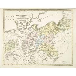
Karta öfver Preussiska riket.
An very rare map of Eastern part of Germany, with Pomerania and part of present-day Poland with Swedish text. This is an updated version of his map of 1820 and is now dat...
- $150 / ≈ €132
Place & Date: A. Wiborgs förlag, Stockholm, ca. 1848

Karta öfver södra delen af Sverige.
An very rare map of Sweden with Swedish text. This is an updated version of his map of 1822 and is now dated 1839. In upper right corner Suppl. 1.From his atlas "Geo...
- $150 / ≈ €132
Place & Date: A. Wiborgs förlag, Stockholm, ca. 1848
Karta öfver Europa.
An very rare map of Europe with a Swedish text. The map is dated 1839.Published as a supplement map in his atlas "Geographisk Hand-Atlas" first published in 181...
- $75 / ≈ €66
Place & Date: A. Wiborgs förlag, Stockholm, ca. 1848
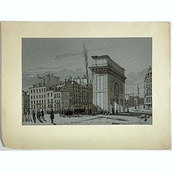
La Porte de S. Martin 24 Juin 3 heures du matin.
A view of St. Martin a well known place in Paris, by the French draughtsman André Durand.
- $100 / ≈ €88
Place & Date: Paris, 1848

Czaritzana bei Moskau. (Tsaritsyno In Moscow)
Steel engraving with a panoramic view of the Tsaritsyn Palace In Moscow, published in "Meyers Universum oder Abbildung und Beschreibung des Sehenswerthesten und Merk...
- $20 / ≈ €18
Place & Date: Hildburghausen, 1848

Das Zeughaus in Moscau.
Steel engraving of the Kremlin, published in "Meyers Universum oder Abbildung und Beschreibung des Sehenswerthesten und Merkwürdigsten der Natur und Kunst auf der g...
- $25 / ≈ €22
Place & Date: Hildburghausen, 1848

Kloster des Ivan Velekoi in Moscau.
Steel engraving of the Kremlin, published in "Meyers Universum oder Abbildung und Beschreibung des Sehenswerthesten und Merkwürdigsten der Natur und Kunst auf der g...
- $25 / ≈ €22
Place & Date: Hildburghausen, 1848
Kertsch im südlichen Russland. (Kerch)
Steel engraving with a panoramic view of the town of Krech, published in "Meyers Universum oder Abbildung und Beschreibung des Sehenswerthesten und Merkwürdigsten d...
- $15 / ≈ €13
Place & Date: Hildburghausen, 1848

Zarskoe. (Tsarskoye Selo)
Steel engraving with a panoramic view of the town of Zarskoe, published in "Meyers Universum oder Abbildung und Beschreibung des Sehenswerthesten und Merkwürdigsten...
- $20 / ≈ €18
Place & Date: Hildburghausen, 1848
![Bataille de Pultusk, le 26 Decembre 1806. [manuscript map]](/uploads/cache/38810-250x250.jpg)
Bataille de Pultusk, le 26 Decembre 1806. [manuscript map]
Manuscript map of the siege of Pultusk (located on the west bank of the River Narew approximately 50 kilometres (31 mi) north of Warsaw), on 26 December 1806. With a colo...
- $1750 / ≈ €1541
Place & Date: Breda, 1849
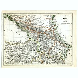
Der Kaukasische Istmus . . .
Detailed contemporary colored map of the countries of the Caucasus Mountains. Steel engraving appeared in "Meyer's Lexicon. Atlas der Geographie". Engraved by C...
- $45 / ≈ €40
Place & Date: Hildburghausen, 1849
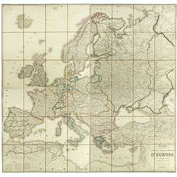
Carta geografica statistica e stradale d'Europa diseguata ed insica da Stanislao Stucchi. . . in Milano 1849.
Large engraved folding map of Europe (1545x1570 mm), consisting of 54 plates linen backed, the boundaries in early hand-color.Stanislao Stucchi was an engraver and printe...
- $600 / ≈ €528
Place & Date: Milan, Turin, 1849
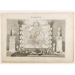
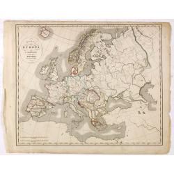
Europe.
While the map itself is quite simple without a great deal of detail, the surrounding engravings make this one of the most decorative 19th century maps. The map is frame...
- $150 / ≈ €132
Place & Date: Paris 1850

Dordrecht.
Attractive lithography showing a Dutch street scene, printed by C.W.Mieling and lithographed by Jan Weissenbruch. Published in Kunst Kroniek .
- $50 / ≈ €44
Place & Date: The Hague 1850
Plan du Champ de Bataille de la Moskowa
Prepared by Thunot Duvotenay (1796-1875), a French geographer and publisher. Detailed map taken from: "Thiers, Atlas de l' Histoire du Consulat et de l' Empire"...
- $150 / ≈ €132
Place & Date: Paris, 1850

(View of the Moscow Kremlin, seen from the Moskva River in the south).
Anonymous, likely Russian School gouache drawing of Moscow Kremlin. The Kremlin is depicted in a typical 19th century romantic style and is seen from the Moskva river in ...
- $3000 / ≈ €2641
Place & Date: Russia, ca. 1850

Der Kreml in Moscau.
View of Moscow with in the background the Kremlin. Original steel engraving, published by Bibliographisches Institut Hildburghausen. Engraved by H.Hauser.
- $30 / ≈ €26
Place & Date: Hildburghausen, 1850

Eglise de Notre Dame de Vladimir.
The church of Holy Mary in Vladimi with in the foreground a ceremony with bishops, monks and faithful viewers. Below a caption in French and in Cyril.
- $45 / ≈ €40
Place & Date: Russia or France, ca. 1850
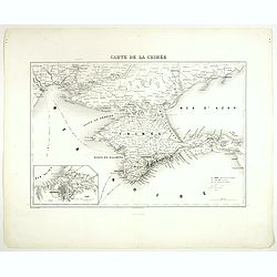
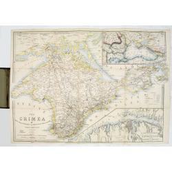
Carte de la Crimée.
Attractive map of Crimea with inset plan of Sevastopol, prepared by Alexandre Aimé Vuillemin (1812-1886). A road system and the ferry lines are drawn in.Engraved by Jaco...
- $150 / ≈ €132
Place & Date: Paris, ca. 1850

Moscau von der Kreml-Seite.
Steel engraving with a panoramic view of the Kremlin in Moscow, published in "Meyers Universum oder Abbildung und Beschreibung des Sehenswerthesten und Merkwürdigst...
- $20 / ≈ €18
Place & Date: 1850

Archangel.
Steel engraving of Archangel, published by the German publishing company Bibliographisches Institut which was founded 1826 in Gotha by Joseph Meyer, moved 1828 to Hildbur...
- $25 / ≈ €22
Place & Date: Hildburghausen, 1850
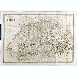
Carte de la Suisse . . .
Detailed canvas map of Switzerland.
- $75 / ≈ €66
Place & Date: Paris, 1850

Dutch street scene.
Attractive lithography showing a Dutch street scene, lithographed by F.H. Weissenbruch after a painting of Jan Weissenbruch.
- $50 / ≈ €44
Place & Date: The Hague, 1850

Carte des environs de Pau. . .
Folding map of Pau and its surroundings, being a reduced version of the map by Comte Dulong de Rosnay and engraved by Nicolas Delamare and published by Lafon.More about f...
- $75 / ≈ €66
Place & Date: Pau, Lafon, 1840-1850
![[Original drawing: Fisher's ships on the beach of Scheveningen.]](/uploads/cache/984-250x250.jpg)
[Original drawing: Fisher's ships on the beach of Scheveningen.]
Unique pencil drawing: Typical Dutch beach life with flat-bottomed ships on the beach of Scheveningen. Signed in the lower right corner and on the back site with P.A....
Place & Date: c. 1850

Arnhem
Attractive lithography showing a street scene in Arnhem. Lithographed by Jan Weissenbruch, published by C.W. Mieling, included in Kunst Kroniek.
- $65 / ≈ €57
Place & Date: The Hague, 1851
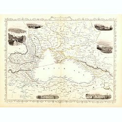
Black Sea.
Decorative steel engraved map of the Black Sea with inset views of Sebastopol and Odessa. There are also vignettes of Constantinople, Sinope and Varna. Taken from "T...
- $110 / ≈ €97
Place & Date: London, London Printing and publishing Company of London, ca. 1851
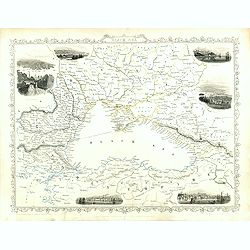
Black Sea.
Decorative steel engraved map of the Black Sea with inset views of Sebastopol and Odessa. There are also vignettes of Constantinople, Sinope and Varna. Taken from "T...
Place & Date: London, London Printing and publishing Company of London, ca. 1851
Black Sea.
Decorative steel engraved map of the Black Sea with inset views of Sebastopol and Odessa. There are also vignettes of Constantinople, Sinope and Varna. Taken from "T...
- $90 / ≈ €79
Place & Date: London, London Printing and publishing Company of London, ca. 1851
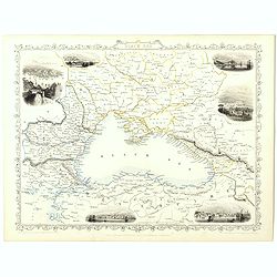
Black Sea.
Decorative steel engraved map of the Black Sea with inset views of Sebastopol and Odessa. There are also vignettes of Constantinople, Sinope and Varna. Taken from "T...
- $90 / ≈ €79
Place & Date: London, London Printing and publishing Company of London, ca. 1851
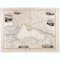
Black Sea.
Decorative steel engraved map of the Black Sea with inset views of Sebastopol and Odessa. There are also vignettes of Constantinople, Sinope and Varna. Taken from "T...
Place & Date: London, London Printing and publishing Company of London, ca. 1851
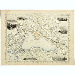
Black Sea.
Decorative steel engraved map of the Black Sea with inset views of Sebastopol and Odessa. There are also vignettes of Constantinople, Sinope and Varna. Taken from "T...
- $90 / ≈ €79
Place & Date: London, London Printing and publishing Company of London, ca. 1851
Europe.
Fine manuscript map of Europe with relief shown pictorially. Signed by the author in the lower right corner.Lower left Juillet 1852.
- $150 / ≈ €132
Place & Date: Paris, 1852

Dépt. De La Haute Loire. N°42.
Map of the Upper Loire region in France.Lovely map from one of the last decorative atlases of the nineteenth century.The rather simple map is framed by medallion portrait...
- $50 / ≈ €44
Place & Date: Paris, A. Combette, 1852
![Dépt. du Morbihan. N°. 55. [ Morbihan, Belle-Ile ]](/uploads/cache/43041-250x250.jpg)
Dépt. du Morbihan. N°. 55. [ Morbihan, Belle-Ile ]
Map of the Morbihan region in Brittany. Including "Belle-Ile".Lovely map from one of the last decorative atlases of the nineteenth century.The rather simple map...
Place & Date: Paris, A. Combette, 1852
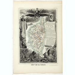
Dépt. De La Corse. N°19.
Map of the Corsica island.Lovely map from one of the last decorative atlases of the nineteenth century.The rather simple map is framed by elaborate border showing regiona...
- $150 / ≈ €132
Place & Date: Paris, A. Combette, 1852
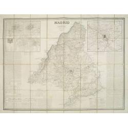
Madrid por el Teniente Coronel, Capítan de Ingenieros D. Francisco Coello. Las notas estadisticas é historicas han sido escritas por D. Pascual Madoz. Madrid 1853.
Second edition of this important and very detailed map of the region of Madrid prepared by Francisco Coello (1822 - 1898) and improved by Pascual Madoz (1806 - 1870). Eng...
- $400 / ≈ €352
Place & Date: Madrid, 1853

Kronstat From The Russian Survey . . .
Scarce chart of the Island of Kronstat, the primary defensive position for the Russian Navy in defense of Russia's Czarist Capital of St. Petersburg.Published on the eve ...
- $500 / ≈ €440
Place & Date: London, 1853
The Crimea by James Wyld Geographer to the Queen & H.R.H. Prince Albert.
The second edition of this folding map of Crimea. In the upper right corner, an inset map of the areas around the Black Sea, "The Town & Harbor of Sevastopol wit...
Place & Date: London, 1854
Selling price: $250
Sold in 2017
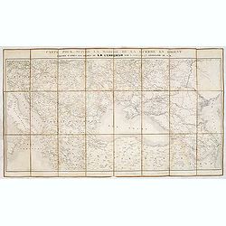
Carte pour suivre la marche de la guerre en Orient, dressée d'après les ordres de l'empereur: par L. Sagansan.
Detailed folding map of the theatre of war in the Balkans, Ukraine and around the Black Sea, indicating the Austrian, Russian and Turkish spheres of influence, prepared b...
Place & Date: Paris, ca. 1854
Selling price: $50
Sold in 2019
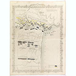
Plan of the battle of Alma.
Fine plan drawn and engraved by John Rapkin "from English and French Official Documents" Published 1858 by the London Printing and Publishing Co., London. Shows...
- $150 / ≈ €132
Place & Date: London, 1854
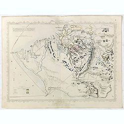
Siege of Sebastopol.
Detailed map of the Siege of Sebastopol. After the Battle of the Alma, the Allies proceeded to Sebastopol and commenced the Siege on September 26th, 1854. This is a steel...
- $150 / ≈ €132
Place & Date: London, 1854
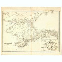
The Crimea.
Map of Crimea and the Sea of Azov. In lower right corner inset map showing Sebastopol region.
- $50 / ≈ €44
Place & Date: London, 1854
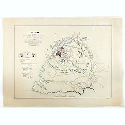
Positions occupées par les armées françaises et anglaises devant Sevastopol.
Map of the French and English armies positions in Sebastopol.Read more about The Crimean War - The Siege of Sevastopol. [+]
- $350 / ≈ €308
Place & Date: Paris, 1854
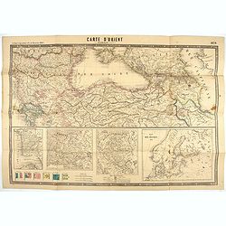
Carte d'Orient par Kraminski ingénieur.
Large map of Orient, with an insert of four maps (Constantinople plan - Map of Europe - Map of Russia - Plan of Baltic sea). With flags in the lower left part. color key ...
Place & Date: Paris, 1854
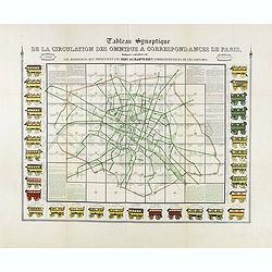
Tableau synoptique de la circulation des omnibus à correspondances de Paris.
Synoptic table of the circulation of omnibuses with connections of Paris indicating at first sight the resources presented by the one hundred and sixty-seven connections ...
- $750 / ≈ €660
Place & Date: Paris, ca. 1854
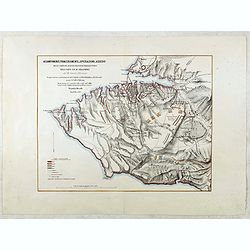
Accampamenti, Trinceramenti, ed Operazioni di Assedio...
Detailed plan of the Allied siege of Sebastopol in 1854-1855 during the Crimean War, showing the allied French, English and Turkish positions, and those of the Russians, ...
- $400 / ≈ €352
Place & Date: Naples, 1855
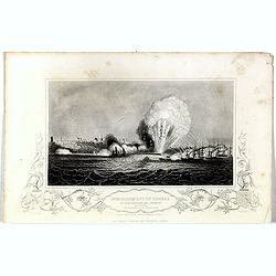
Bombardment of Odessa by the English and French April 22 1854, explosion on the imperial mole . . .
Scene from the Crimea war, showing a bombardment of Odessa, 22nd April 1854 (during Crimean War, 1853-56), by English and French forces, explosion imperial mole (breakwat...
- $55 / ≈ €48
Place & Date: London, 1855