Browse Listings in Europe

Homme d'Ausbourg.
Originally hand-colored mezzotint from 'Costumes civils actuels de tous les peuples connus'. After Jacques Grasset de Saint-Sauveur. As an etcher, drawer and writer, Gras...
- $50 / ≈ €44
Place & Date: Paris,1806
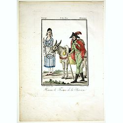
Homme & Femme de la Baviere.
Originally hand-colored mezzotint from 'Costumes civils actuels de tous les peuples connus'. Engraved by Félix Mixelle after Jacques Grasset de Saint-Sauveur.As an etche...
- $50 / ≈ €44
Place & Date: Paris,1806

Femme Tschermifse.
Originally hand-colored mezzotint from 'Costumes civils actuels de tous les peuples connus'. Originally hand-colored mezzotint of Native Americans engraved by Félix Mixe...
- $50 / ≈ €44
Place & Date: Paris,1801-1806

Femme Touralinze.
Originally hand-colored mezzotint from 'Costumes civils actuels de tous les peuples connus'. Originally hand-colored mezzotint of Native Americans engraved by Félix Mixe...
- $50 / ≈ €44
Place & Date: Paris,1801-1806
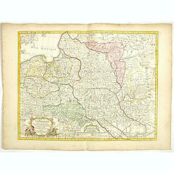
La Pologne Dressée sur ce qu'en ont donné Starovolsk, Beauplan, Hartnoch. . .
This is a late edition of the De L'Isle copper plate with a date of 1806. The copper plate was used many times and has several erased addresses. This one with address &qu...
- $750 / ≈ €660
Place & Date: Paris, 1806

Karakasse.
Originally hand-colored mezzotint of a native Tartary man holding a bear's head engraved by Félix Mixelle and Lachaussée Jeune after Jacques Grasset de Saint-Sauveur. F...
- $25 / ≈ €22
Place & Date: Paris,1801-1806

(Die Fontanka beim kaiserlichen Garten in Petersbourg.)
Fontanka River at the Summer Garden in Saint Petersburg. Part of a set of 14 loose and individually mounted plates of views of St. Petersburg and Moscow, plus one plate o...
- $100 / ≈ €88
Place & Date: St. Peterdburg, 1806
![Fille Wotÿake [together with] Femme Wotÿake.](/uploads/cache/36934-250x250.jpg)
Fille Wotÿake [together with] Femme Wotÿake.
Set of two originally hand-colored mezzotints of Native Russians engraved by Félix Mixelle and Lachaussée Jeune after Jacques Grasset de Saint-Sauveur.As an etcher, dra...
- $35 / ≈ €31
Place & Date: Paris,1801-1806
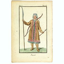
Jacout.
Originally hand-colored mezzotint from 'Costumes civils actuels de tous les peuples connus'. Originally hand-colored mezzotint of Native Americans engraved by Félix Mix...
- $50 / ≈ €44
Place & Date: Paris,1801-1806
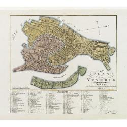
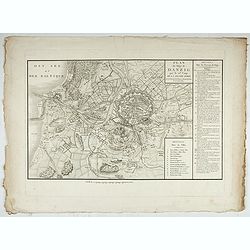
Plan von Venedig.
An uncommon and finely rendered town-plan of Venice. The work is highly detailed and provides a 133-point legend identifying the town's key sites and places of import. L...
Place & Date: Weimar, 1807
Accueil Consultation Plan du Siège de Danzig par le 10me. Corps de la Grande Armée, Avec les travaux des Français, tels qu'ils étaient le 25 Avril 1807.
A map of the siege of Danzig, 19 March-24 May 1807, showing the positions of the French siege works as they stood on 23 April. Napoleonic Wars (1803-15). Oriented with so...
Place & Date: Paris, after 1810

Département des Apennins Divisé en 3 Arrondissemens et en 18 cantons.
Published in the "Atlas National de France" at Chanlaire. Engraved by P.A.F. Tardieu. Represents the department of Apennines which was under French administrati...
Place & Date: Paris, 1790-1811
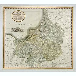
A New Map of the Kingdom of Prussia with its Divisions Into Provinces and Governments. . .
A fine map by John Cary of Prussia, in what is now northern Poland and Lithuania. John Cary was considered "the most representative, able and prolific of English car...
- $250 / ≈ €220
Place & Date: London, 1811

Grossbritanien und Irland.
Nice small map of the British isles and Ireland by Johannes Walch in his rare Allgemeiner Atlas Nach den bewährsten Hülfsmitteln und astronomischen Ortsbestimungen…, ...
- $50 / ≈ €44
Place & Date: Augsburg, 1812

Deutschland (with Poland)
Nice small map of Germany by Johannes Walch in his rare Allgemeiner Atlas Nach den bewährsten Hülfsmitteln und astronomischen Ortsbestimungen…, edition of 1812.Johann...
- $75 / ≈ €66
Place & Date: Augsburg, 1812

Westphalen.
Nice small map of Westphalia in Germany by Johannes Walch in his rare Allgemeiner Atlas Nach den bewährsten Hülfsmitteln und astronomischen Ortsbestimungen…, edition ...
- $50 / ≈ €44
Place & Date: Augsburg, 1812
Brandenburg und Pommern.
Nice small map of Brandenburg and Pommeren, centered on Berlin by Johannes Walch in his rare Allgemeiner Atlas Nach den bewährsten Hülfsmitteln und astronomischen Ortsb...
- $75 / ≈ €66
Place & Date: Augsburg, 1812

Schweiz.
Nice small map of Switzerland by Johannes Walch in his rare Allgemeiner Atlas Nach den bewährsten Hülfsmitteln und astronomischen Ortsbestimungen…, edition of 1812.Jo...
- $60 / ≈ €53
Place & Date: Augsburg, 1812

Entrée des Français dans la ville de Moscou . . .
View of the French's army entering Moscow on 14 September 1812 during the Napoleonic Wars (1800-1815) in Russia.
- $75 / ≈ €66
Place & Date: Brussels, ca. 1812

Passage de la Berezinas.
Set of four views of The Battle of Berezina (or Beresina) which took place from 26 to 29 November 1812, between the French army of Napoleon, retreating after his invasion...
Place & Date: ca. 1812

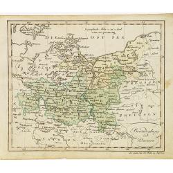
General Charte der Preussischen Monarchie in zwey Blattern. . .
Uncommon and detailed map of Kingdom of Prussia with present day Poland and Germany. Uncommon map engraved by Ludwig Hess and published in Weimar by Fr. Wilhelm Streit.
- $1000 / ≈ €880
Place & Date: Weimar, 1812
Smolensko.
View of this small town in Russia just before the First Battle of Smolensk which took place on August 17, 1812, between 175,000 men of the army under Napoleon Bonaparte a...
- $225 / ≈ €198
Place & Date: London, 1814

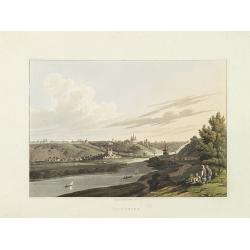
Vue de la ville de St. Pétersbourg capitale de la russie prise du côté de la Fontanka . . .
This aquatint print figures the town of St. Peterburg. With address "A Paris chez le Coeur graveur, rue Mouffetard, N° 89 et chez Bance aîné, rue Saint Denis, N°...
- $100 / ≈ €88
Place & Date: Paris, Le Cœur et Bance ainé, ca 1814
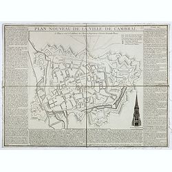
Plan nouveau de la ville de Cambrai.
Nice town-plan of Cambrai, with its fortifications and the citadel, decorated with the cathedral in lower right corner. The borders contain a historical description of th...
Place & Date: Cambrai, 1814
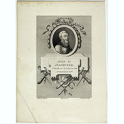
Juan II Jvanovitz, il monta sur le trône en 1353, et mourut en 1358.
Portrait of Juan II Jvanovitz., engraved by Louis Legrand (1723-1807).
- $50 / ≈ €44
Place & Date: Paris, 1814

Demitri III Constantinovitz, regne en 1359, est detrône en 1361.
Portrait of Demitri III Constantinovitz., Grand Duke of Russia, engraved by C.-N. Malapeau.
- $75 / ≈ €66
Place & Date: Paris, 1814

Fédor Borissovitz il succéda a son père, fut détroné et étouffé en 1505.
Portrait of Fédor Borissovitz. (1589 - 1605), engraved by Louis Pauquet (1759-1824).
- $75 / ≈ €66
Place & Date: Paris,1814
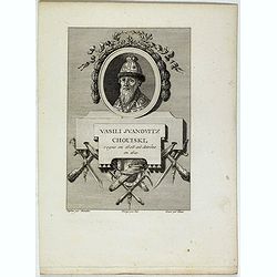
Vasili Juanovitz Chouiski regne en 1606 est detrône en 1610.
Portrait of Vasili Juanovitz Chouiski or Vasili IV of Russia (1552 – 1612) was Tsar of Russia between 1606 and 1610 after the murder of False Dmitriy I. His reign fell ...
- $45 / ≈ €40
Place & Date: Paris, 1814
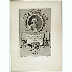
Demitri IV Juanovitz Donski regne en 1362, et meurt en 1389.
Portrait of Demitri IV Juanovitz or Vasili IV of Russia who was Tsar of Russia between 1606 and 1610 after the murder of False Dmitriy I. His reign fell during the Time o...
- $75 / ≈ €66
Place & Date: Paris, 1814

Carte du royaume de France divisé en 87 départemens / dressée par Brion de la Tour..., où sont tracées les nouvelles limites fixées par le traité de paix du 30 mai 1814. . .
Very decorative and uncommon map of France, with Corsica prepared by Brion de la Tour showing the new border set by the Peace Treaty of May 30, 1814. Engraved by Chaumier...
- $750 / ≈ €660
Place & Date: Paris, ca. 1814

Gefecht bei Daoughelichki, den July 1812.
Rare German print showing the siege of Daoughelichki, July 1812, during the French Russian Campaign, which ended in Napoleon's defeat.
- $150 / ≈ €132
Place & Date: Nuremberg, ca. 1815
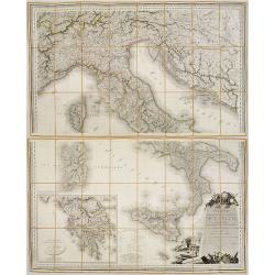
Carte Statistique, Politique, et Mineralogique de l'Italie o'u sont tracées toutes les routes, relais, et distances de postes. . .(2 Maps)
Folding map, extending west to east from Monaco to Otranto and north to south from The Alps to Malta, inset of Greece,. Cartouche depicting Rome and her classical past. P...
- $1000 / ≈ €880
Place & Date: Paris, 1816

Charte des ganzen Russischen Reichs in Europa und Asien : Nach den neuesten und sichersten astronomischen Ortsbestimmungen entworfen und berichtiget auf der Sternwarte Seeberg bey Gotha gezeichnet von I. C. M. Reinecke. . .
Uncommon two-sheet map of Russia, prepared by Johann Matthias Christoph Reinecke (1770-1818). The map's information is off by 20 degrees longitude as the prime meridian ...
- $750 / ≈ €660
Place & Date: Weimar, 1817

Nouveau voyage pittoresque de la France Orné de trois cent soixante gravures exécutées sur des dessins fait d'après nature, et représentant des Vues des principales Villes de France, ...
Large paper copy, printed on quarto format (210x235mm.) on heavy paper. Illustrated with 360 engraved plates, many by Jean-Jerome Baugean. Without the large folding map....
- $2200 / ≈ €1937
Place & Date: Paris, 1817
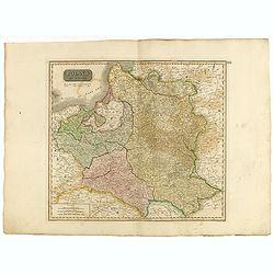
Poland As Divided.
This map covers Poland following Napoleonic Wars and the treaties of the 1815 Congress of Vienna.This map was first published in Thomson's New General Atlas of 1814. John...
Place & Date: Edinburgh, 1817
Situations = Plan. Der gegend zwischen der Kayserlich Königlichen Granitz Festung Essegg, und dem Dorffe Bellia....
Manuscript plan showing the Kopački Rit nature park a swampy area of Baranja between Osijek (Essegg) and Bilje. The river Drava in upper right corner. The pen an...
Place & Date: Vienna, 1819
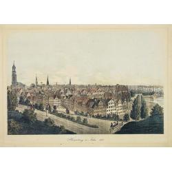
Hamburg im Jahre 1813
Decorative lithographed view of Hamburg. The print is issued in colors but finished by hand.
- $150 / ≈ €132
Place & Date: Germany,1820
![[No tittle] Partie de la Prusse.](/uploads/cache/30632-250x250.jpg)
[No tittle] Partie de la Prusse.
Detailed map of the south of Baltic Sea. With a paper printed label of the Paris map seller Jean Goujon who was active from 1793-1826. The label carries the address of Ru...
- $90 / ≈ €79
Place & Date: Paris, c. 1820
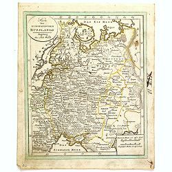
Karte des Europaeischen Russland. . ..
Nice small map of Russia.
- $100 / ≈ €88
Place & Date: Augsburg, 1820

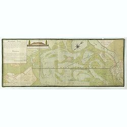
Tableau d'assemblage de la carte des environs de Versailles dite chasses impériales.
Key sheet to the rare 12 sheet map "Carte topographique des environs de Versailles dite des Chasses Impériales, levée et dressée de 1764 à 1773 par les ingénieu...
Place & Date: Paris, ca. 1820

Catharina II.
Portrait of Catharina II (1729-1796) or Catherine the Great, Empress of Russia. During the reign of the flamboyant and powerful Empress Catherine II of Russia, whose long...
- $60 / ≈ €53
Place & Date: Germany, ca. 1820

Le Baron d'Amstett. Ministre de Russie.
Full portrait of Johann Protasius von Anstett (* 1766 in Straßburg; † 14. Mai 1835) after Lieder and lithographed by G.Engelmann. Anstett, son of a lawyer in Strasbour...
- $40 / ≈ €35
Place & Date: Paris, ca. 1820
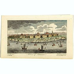
A View of Astracan. (Astrakhan)
A striking and highly detailed copper engraved panoramic view of Astrakhan, Russia, with its buildings, churches and town wall. The River Volga in the foreground. Several...
- $50 / ≈ €44
Place & Date: London, 1820

Prise du Grand Convoi de Girone le 26 Fbie 1809.
Fine lithography showing a battle scene during Third Siege of Girona by Godefroy Engelmann" after a drawing by C. Langlois. Godefroy Engelmann was born in 1788 in M�...
- $75 / ≈ €66
Place & Date: Paris, ca. 1820
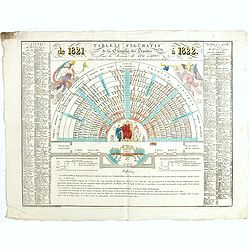
Tableau figuratif de la Chambre de Députés . . .
Figurative table of the Chamber of Deputies for the session of 1821. Showing as accurately as possible the place usually occupied by each of its members.
Place & Date: Paris, ca. 1821
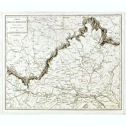
Carte de Moravie Dessinée et Gravée par Ambroise Tardieu.
Very detailed map including Vienna and the Czech Republic with Prague Olmutz.
- $40 / ≈ €35
Place & Date: Paris, 1822
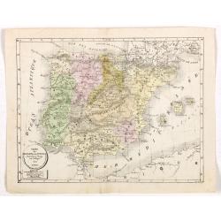
Carte de l'Espagne et du Portugal dréssée pour l'usage des Collèges 1822.
Uncommon lithographed map of Spain and Portugal taken from " Atlas Géographique. Géographie moderne actuelle. Pour l'usage des Collèges."
Place & Date: Paris, 1822

Impero della Russia in Europa a riserva delle ultime Conquiste sulla Polonia.
Charming map of the European part of Russia, including Finland, from the rare atlas Atlante Tascabile o sia Serie di Num. XXI Cartine Geografiche nelle quali si In Roma...
- $200 / ≈ €176
Place & Date: Rome, 1823
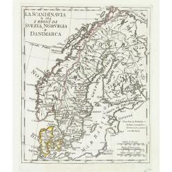
La Scandinavia o sia i regni di Svezia, Norvegia e Danimarca.
Charming and uncommon map of Scandinavia, including Norway, Sweden, Denmark, Finland and part of Russia, from the rare atlas Atlante Tascabile o sia Serie di Num. XXI Car...
Place & Date: Rome, 1823

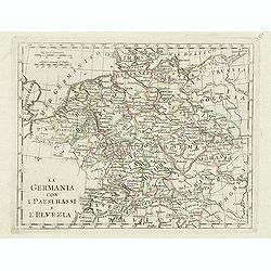
La germania con i Paesibassi e l'elvezia.
Charming map of Germany, The Netherlands, Switzerland and part of Poland from the rare atlas Atlante Tascabile o sia Serie di Num. XXI Cartine Geografiche nelle quali si ...
- $80 / ≈ €70
Place & Date: Rome, 1823
La germania con i paesi bassi e l'elvezia.
Charming map of Germany, Netherlands, Switzerland, Austria from the rare atlas Atlante Tascabile o sia Serie di Num. XXI Cartine Geografiche nelle quali si rappresenta in...
- $65 / ≈ €57
Place & Date: Rome, 1823
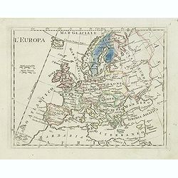
L'Europa.
Charming map of Europe from the rare atlas Atlante Tascabile o sia Serie di Num. XXI Cartine Geografiche nelle quali si rappresenta in ristretto lo Stato Attuale di tutte...
- $60 / ≈ €53
Place & Date: Rome, 1823
Carte de la Georgie et du Pays des Ossetes, Tcherkesses et Mitzdcheghi, Par Jules Klaproth (1823).
Detailed manuscript map of Georgia, based upon an 1823 map by Jules Klaproth. The map depicts the rugged terrain of Georgia and southern Russia in impressive detail from ...
- $4000 / ≈ €3522
Place & Date: Paris, ca. 1823
![[Untitled map of a part of Poland and Prussia].](/uploads/cache/25710-250x250.jpg)
[Untitled map of a part of Poland and Prussia].
Large folding map, being upper right part of a multi-sheet map, showing the northern part of Poland with good detail around Gdansk. Published by Jean Claude Dezauche (17...
- $400 / ≈ €352
Place & Date: Paris, ca. 1816-1824

Russie
Attractive map of Russia with decorative borders depicting typical artefacts and produce of the continent. Published in Les jeunes voyageurs en Europe.. . Engraved by J.G...
- $100 / ≈ €88
Place & Date: Brussels, 1824

Vue du Kremlin à Moscou.
View of the Kremlin, lithographed by Brocas after a design by Edouard de Montulé. Lithography was printed by Langlumé in Paris. Taken from : Voyage en Angleterre et en ...
- $125 / ≈ €110
Place & Date: Paris, Arthus Bertrand, 1825

Vue du Kremlin.
View of the Kremlin, lithographed by Brocas after a design by Edouard de Montulé. Lithography was printed by Langlumé in Paris. Taken from : Voyage en Angleterre et en ...
- $125 / ≈ €110
Place & Date: Paris, Arthus Bertrand, 1825

Dédié à l'armée d'Espagne. Prise de Logrono.
Very decorative plate showing the taking of Logrono in 1823, decorative mezzotint by Louis-François Charon (1783-1839) after F.N.Martinet. Published by Jean, Editeur, Ma...
- $75 / ≈ €66
Place & Date: Paris, 1825

Habillement des Groënlandais.
Natives of Greenland. This aquatint engraved plate was color printed on fine wove paper of a soft aged white color, bearing the embossed seal of authenticity impressed at...
- $75 / ≈ €66
Place & Date: Milan, 1827

Bernoise.
A decorative costume print from "Costume de div. Pays", No.17. Engraved by Getine after Lanté.
- $80 / ≈ €70
Place & Date: Paris, c. 1827

Carte de l'Espagne Dressée par Guillaume Delisle sur la description de Rodrigo Mendez Sylva . . .. Le tout augmenté et vérifié en 1789. Par Phil. Buache, de l'Académie des Sciences.
Map of Spain and Portugal, including the North African coast and good detail for Majorca, Minorca and Ibiza. Published by Dezauche at his address Rue de Sorbonne, n°9, a...
- $175 / ≈ €154
Place & Date: Paris, 1827

Europe. Naples et Sicile. N.26.
Detailed map including lower half of Italy with the island of Sicily.From his famous Atlas Universel . This atlas was one of the most remarkable world atlases ever produc...
Place & Date: Brussels, 1825-1827
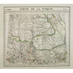
Europe. Partie de la Turquie. N°21.
Detailed map including Hungary and Romania.From his famous Atlas Universel . This atlas was one of the most remarkable world atlases ever produced, anticipating the Inter...
Place & Date: Brussels, 1825-1827
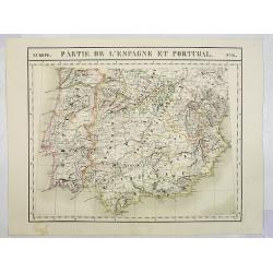
Europe. Partie de l'Espagne et Portugal. N°24.
Detailed map including Southern part of Spain and Portugal.From his famous Atlas Universel . This atlas was one of the most remarkable world atlases ever produced, antici...
Place & Date: Brussels, 1825-1827

Europe. Partie de l'Angleterre. N°7.
Detailed map including Northern part of England.From his famous Atlas Universel . This atlas was one of the most remarkable world atlases ever produced, anticipating the ...
- $100 / ≈ €88
Place & Date: Brussels, 1825-1827
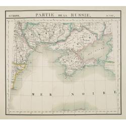
Europe. Partie de la Russie. N°22.
Detailed map of the Crimea region.From his famous Atlas Universel . This atlas was one of the most remarkable world atlases ever produced, anticipating the International ...
Place & Date: Brussels, 1825-1827
Selling price: $210
Sold in 2010
![[Costume plate of Grebenski Cossacks in the Caucasus]](/uploads/cache/62339-250x250.jpg)
[Costume plate of Grebenski Cossacks in the Caucasus]
Aquatint costume plate of Grebenski Cossacks in the Caucasus. Plate N° 10. From Giulio Ferrario's work Le Costume ancien et moderne ou histoire du gouvernement, de la mi...
Place & Date: Milan, 1827
![[Costumes des Karabulaks - Caucase]](/uploads/cache/62344-250x250.jpg)
[Costumes des Karabulaks - Caucase]
Four men from the Caucasus in typical dress from the Karabulaks tribe. Plate N° 15. from Giulio Ferrario's work "Le Costume Ancien et Moderne ou Histoire du gouvern...
Place & Date: Milan, 1827

Intérieur d'une maison groënlandaise.
This aquatint engraved plate was color printed on fine move paper of a soft aged white color, bearing the embossed seal of authenticity impressed at the time of publicati...
- $75 / ≈ €66
Place & Date: Milan 1827
![[Calmucchi].](/uploads/cache/34988-250x250.jpg)
[Calmucchi].
Aquatint costume plate of the Kalmyk people. The name is given to the Oirats in Russia, whose ancestors migrated from Dzungaria in 1607. They created the Kalmyk Khanate i...
- $50 / ≈ €44
Place & Date: Milan, 1827

Carte de la Russie occidentale et du Royme. de Pologne par A. Brue, Geographe du Roi . . .
Steel engraved map of Russia and Poland from his "Universal Atlas of physical geography, politics, ancient & modern."
- $150 / ≈ €132
Place & Date: Paris, 1827

Le couvent de Nenski.
A rare lithography published by Alexandre Ivanovitch Pluchard (1777-1832) in St.-Petersburg, one of the first lithographs made in St. Petersburg. The lithographs are publ...
- $550 / ≈ €484
Place & Date: St.-Petersburg, 1827
![[Untitled]. St. Petersburg.](/uploads/cache/37444-250x250.jpg)
[Untitled]. St. Petersburg.
A rare lithography published by Alexandre Ivanovitch Pluchard (1777-1832) in St.-Petersburg, one of the first lithographs made in St. Petersburg. The lithographs are publ...
- $400 / ≈ €352
Place & Date: St.-Petersburg, 1827

Le Palais imperial a Kamenoi Ostroff.
Fine lithography published by Alexandre Pluchart in St.-Petersburg, one of the first lithographs made in St. Petersburg. The lithographs are published in installments. Th...
- $450 / ≈ €396
Place & Date: St.-Petersbourg, 1827

Pierre Ier.
A rare lithography published by Alexandre Ivanovitch Pluchard (1777-1832) in St.-Petersburg, one of the first lithographs made in St. Petersburg. The lithographs are publ...
- $500 / ≈ €440
Place & Date: St.-Petersburg, 1827

Bibliotheque imperiale.
Fine lithography published by Alexandre Ivanovitch Pluchard (1777-1832) in St.-Petersburg, one of the first lithographs made in St. Petersburg. The lithographs are publis...
- $450 / ≈ €396
Place & Date: St.-Petersburg, 1827

1ère habitation de Pierre 1er.
A rare lithography published by Alexandre Ivanovitch Pluchard (1777-1832) in St.-Petersburg, one of the first lithographs made in St. Petersburg. The lithographs are publ...
- $275 / ≈ €242
Place & Date: St.-Petersburg, 1827

Le palais du Grand Duc Nicolas.
Fine and rare lithography published by Alexandre Ivanovitch Pluchard (1777-1832) in St.-Petersburg, one of the first lithographs made in St. Petersburg. The lithographs a...
- $750 / ≈ €660
Place & Date: St.-Petersburg, 1827

Pont d'Isaac et nouvelle Eglise.
A rare lithography published by Alexandre Pluchart in St.-Petersburg, one of the first lithographs made in St. Petersburg. The lithographs are published in installments. ...
- $500 / ≈ €440
Place & Date: St.-Petersburg, 1827