Browse Listings in East Meets West
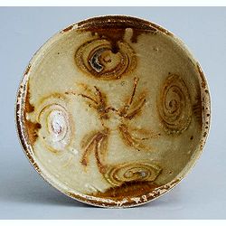
Tang Dynasty Changsha Bowl from the Belitung Wreck.
A beautiful Tang dynasty sancai glazed bowl made in Tongguan county, Changsha city, Hunan province of China mainly for export. Recovered from the Belitung shipwreck. This...
Place & Date: China, Hunan province, 826
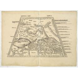
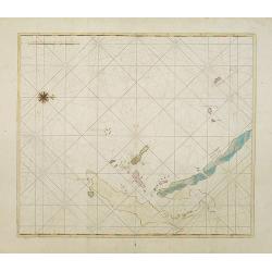
Septima Asie Tabula (Central Asia.)
A woodblock-printed large-format Ptolemaic map showing the region east of the Caspian Sea is labeled SOGDIANA. Sogdia or Sogdiana was an ancient Iranian civilization betw...
Place & Date: Strasburg, 1513
![Septima Asie Tabvla. |Walsseemüller's map of Central Asia and the Silk Road]](/uploads/cache/62137-250x250.jpg)
Septima Asie Tabvla. |Walsseemüller's map of Central Asia and the Silk Road]
Trapezoidal woodcut map showing the area east of the Sarygamysh Lake, about midway between the Caspian Sea and the (former) Aral Sea. It is one of the earliest obtainabl...
Place & Date: Strasburg, J. Schott, 1513
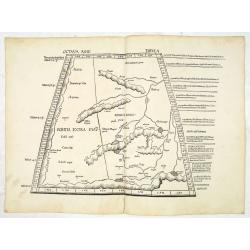
Octava Asie Tabula (The Silk Road Area.)
Woodblock printed large-format map showing Northern India with Central Asia including the Himalayas and China. From the 1513 edition of Waldseemüller's Geographia.In the...
Place & Date: Strasburg, 1513
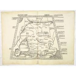
Secunda Asiae Tabula (Ukraine and Russia)
Woodblock printed a large-format Ptolemaic map showing Russia, Ukraine, and the Black Sea region. From the 1513 edition of Waldseemüller's Geographia.One of the earliest...
Place & Date: Strasburg, 1513
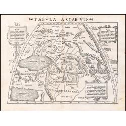
Tabula Asiae VII.
Attractive woodblock map, depicting the Caspian Sea, Black Sea and the Persian Gulf, extending to the Imaus Mountains. according to Ptolemy. In the center of the map is...
- $500 / ≈ €440
Place & Date: Basle, 1542
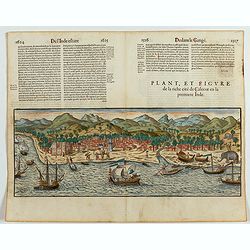
Plan, et figure de la riche cité de Calecut en la premiere Inde.
A rare and early woodcut view of Calcutta in India. Decorated with several ships on the sea, shipbuilding, fishermen and elephants.This woodcut was published in La Cosmog...
Place & Date: Paris, 1575
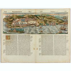
Goa fortissima Indiae urbs in Christianorum potestatem anno Salutis 1509. devenit.
A rare and early woodcut view of Goa in India. Decorated with one ship. This woodcut was published in La Cosmographie Universelle de tout le monde, printed 1575 in two vo...
Place & Date: Paris, 1575
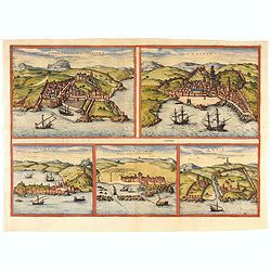
Tingis, Lusitanis, Tangiara. / Tzaffin. / Septa. / Arzilla/ Sala.
Views of the five northern and western African coastal town-view on one sheet: Latin text.From the greatest publication in this genre!. The Civitates was compiled and wri...
- $600 / ≈ €528
Place & Date: Cologne, 1580

Chinae, olim Sinarum Regionis, nova descriptio. Auctore Ludovico Georgio.
The first map of China ever to appear in a Western atlas, west to the top. The first state without "las Philiooinas" somewhere in 1587 added to the plate. When ...
Place & Date: Antwerp, 1584
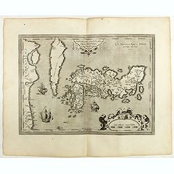
IAPONIAE INSULAE DESCRIPTIO.Ludoico Teisera auctore.
The map was based upon the manuscript draft supplied to Ortelius in about 1592 by the famous official Portuguese chart maker, Luis Teixeira , who was the cartographer t...
Place & Date: Antwerp, 1598
II Pars Indiae Orientalis in qua Johan. Hugonis Linschotani. . .
De Bry's Part II of his "Les Petit Voyages", containing "Pars Indiae Orientalis, in qua Johan. Hugonis Linscotani navagatio in Orientem, 1609", being ...
Place & Date: Frankfurt, Wolffgang Richter, 1609
![[Dutch ship Amsterdam].](/uploads/cache/37948-250x250.jpg)
[Dutch ship Amsterdam].
Text engraving of the Dutch vessel Amsterdam offshore the island of Java near Surabaya from "Premier livre de l'histoire de la navigation aux Indes Orientales, par l...
- $150 / ≈ €132
Place & Date: Amsterdam, Cornille Nicolas, 1609
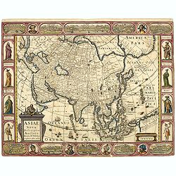
Asiae Nova Descriptio.
Final State of Pieter Van Den Keere's Rare Map of Asia -- The first map of Asia to include decorative panels. Published by N.J.Visscher and engraved by Abraham Goos, embe...
Place & Date: Amsterdam, 1636
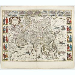
Asia noviter delineata. . .
From 1633 the members of the Blaeu family were official cartographers to the United East India Company and, as such, had access to the most up-to-date cartographic inform...
Place & Date: Amsterdam, 1644
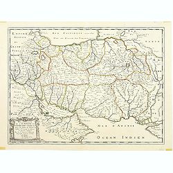
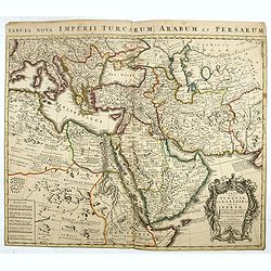
Description de l'Empire du Sophi des Perses tiree en partie de l'Arabe de Nubie, et en partie de plusieurs et diverses Relations.
The map of the Empire of Persia is shown to extend from Baghdad almost to the present-day borders of India. Including part of Saudi Arabia and Oman. Including "Golfe...
- $275 / ≈ €242
Place & Date: Paris, 1650

Japonia Regnum.
It is the first map to correctly show Korea as a peninsula.This was to remain the standard form of Japan until the eighteenth century and although replaced by the maps of...
- $2000 / ≈ €1761
Place & Date: Amsterdam, 1655
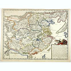
La Chine Royaume. . .
An important and attractive French map of the whole of China, the northern tip of the Philippines, with a strangely curved Korea and an under-sized Taiwan here called &qu...
- $2600 / ≈ €2289
Place & Date: Paris, 1656
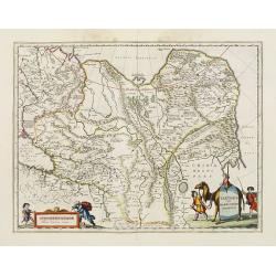
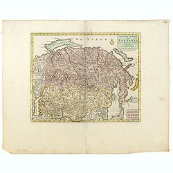
Tartaria sive Magni Chami imperium.
This is a detailed and decorative map of the Tartary and northern part of China, including the Chinese Great Wall, the Caspian Sea, and the Volga River east as far as the...
- $700 / ≈ €616
Place & Date: Amsterdam, 1658
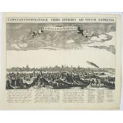
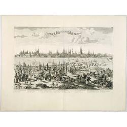
Constantinopolitanae urbis effigies ad vivum expressa.
A rare panoramic town-view of Istanbul with over the whole length of the lower part 3 columns of poems in Latin, Dutch and French and a numbered key 1-29 to the principal...
Place & Date: Amsterdam, 1660
The citie and Castle Zelandia in the Island of Taywan. / Stadt en casteel Zelandia op 't Eilant Taywan.
This important copperplate engraving is one of the earliest European views of Taiwan, depicting the Dutch fortifications and trading settlements on the island's West coas...
- $1600 / ≈ €1409
Place & Date: Amsterdam, 1675

La Ville et le Château de Zélandia dans l' île de Tayovan.
This important copperplate engraving is one of the earliest European views of Taiwan, depicting the Dutch fortifications and trading settlement on the West coast of the i...
- $1800 / ≈ €1585
Place & Date: Amsterdam, 1675
Constantinopolis.
Extremely rare panoramic town-view of Istanbul published by Frederick de Wit. With a numbered key (1-17) to principal places in town and a poem in Latin, Dutch, English a...
- $4000 / ≈ €3522
Place & Date: Amsterdam, 1680

Kam Hi Fils de Chien chi Empereur des Tartares orientaux?.plusieurs titres d'honneur Ecrits de sa propre main.
Very rare and decorative costume plate. Underneath the plate a descriptive text in French. Bears the address AParis Chez Nolin rue St. Jacques à l'Enseigne de la Place d...
- $300 / ≈ €264
Place & Date: Paris ca. 1690
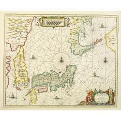
Nova et accurata Japoniae terrae Esonis, ac Insularum adjacentium.
The map is of interest in showing Korea as a curiously shaped island and in revising the shape of the three main Islands of Japan. A re-issue of Janssonius' map with the ...
- $2000 / ≈ €1761
Place & Date: Amsterdam, 1700

A New Map of Great Tartary and China with the adjoining parts of Asia
Two insets show the land to the northeast of China, according to Jesuit information. The map stretches from northern Russia and Nova Zemlya in the northwest to Formosa in...
Place & Date: Oxford, 1700
![[Drawing of a Tulip]](/uploads/cache/06622-250x250.jpg)
[Drawing of a Tulip]
Very detailed and well executed tulip drawing by an unknown artist belonging to the School of Anthony Claesz (1607/8-1649)This drawing was made for a 'Tulip book' painted...
- $1500 / ≈ €1321
Place & Date: The Netherlands c.1700

Collection of rubbings with portraits and biographies of famous Chinese philosophers, poets and legendary wise old men.
Collection of portraits and biographies of famous Chinese philosophers, poets and legendary wise old men. All portraits and text are original rubbings from stone tables d...
- $15000 / ≈ €13207
Place & Date: China or Korea, c. 1701
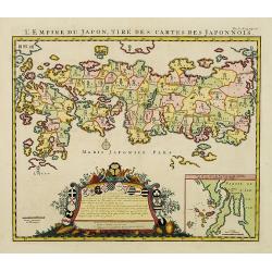
L'Empire du Japon, tire des cartes des Japonnois.
A good impression of this decorative map of Japan based on Reland's map of `1715, one of the earliest to use both Latin names and Japanese characters. With inset of the b...
Place & Date: Amsterdam, 1719
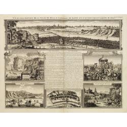
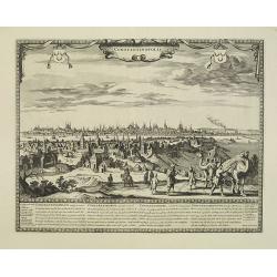
Vue et description de la Ville de Meaco Capitale du Japon. . .
The top part of the print shows a panoramic view of Meaco (Kyoto) at that time the capital of Japan, with a coach and horses in the foreground. Other parts show among oth...
- $750 / ≈ €660
Place & Date: Amsterdam, 1720
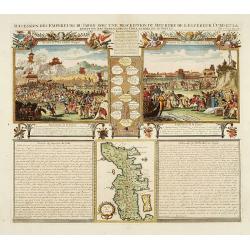
Succession Des Empereurs Du Japon Avec Une Description Du Meurtre De L'Empereur Cubo Et La Reception Des Ambassadeurs Hollandais. . .
The plate is showing the murder of the Emperor Cubo at Kyoto, the arrival of one of the early Dutch embassies.A small map of Honshu in a central panel. Plate from his &qu...
- $400 / ≈ €352
Place & Date: Amsterdam, 1720
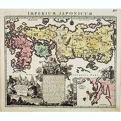
Imperium Japonicum.
The map is based on Engelbert Kaempfer's map of 1727. It shows a much-distorted outline for the Island of Japan and a wonderful decorative cartouche top left.Tobias Conra...
- $1900 / ≈ €1673
Place & Date: Augsburg 1720

Succession Des Empereurs Du Japon Avec Une Description Du Meurtre De L'Empereur Cubo Et La Reception Des Ambassadeurs Hollandais. . .
The plate is showing the murder of the Emperor Cubo at Kyoto, the arrival of one of the early Dutch embassies.A small map of Honshu in a central panel. Plate from his &qu...
Place & Date: Amsterdam, 1720
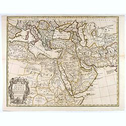
A Map of Turky, Arabia And Persia. Corrected from the latest Travels. . .
FIRST EDITION - Fine Turkish Empire map centered on Saudi Arabia, Cyprus and the Mediterranean Sea. Dated 1711, "Sold by John Senex at the Globe aga inst St. Dunstan...
- $1750 / ≈ €1541
Place & Date: London, 1721
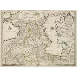
Carte des Pays Voisins de la Mer Caspiene dressee pour l' usage du Roy. . .
The map shows the area east of the Caspian Sea, including parts of Kazakhstan, Turkmenistan, Uzbekistan, and northern Iran. The area eastward from the Caspian is marked '...
- $750 / ≈ €660
Place & Date: Paris, 1723
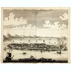
Platte Grond vande Stadt Macao.
A fine view of the city of Macao from Lappa Island showing in schematic blocks the structure of the town. With European vessels and junks in the surrounding water. With n...
- $750 / ≈ €660
Place & Date: Amsterdam, 1724
De Stad Macao.
A fine view of the city of Macao from Lappa Island showing the defenses, the forts, churches and convents: including Fort de Baare, Bon Parto, Fort St Paulo (Monte Fort)....
- $750 / ≈ €660
Place & Date: Amsterdam, 1724
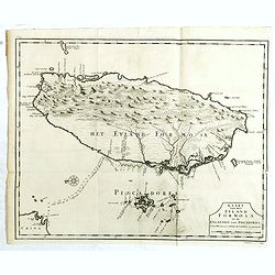
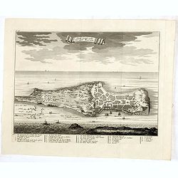
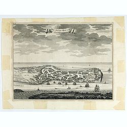
Kaart van het Eyland Formosa en de Eylanden van Piscadores.
The earliest printed map of Taiwan or Formosa. Oriented to the east, with north at the left, covering the entire island and the nearby Pescadores, now known as the Penghu...
- $4000 / ≈ €3522
Place & Date: Amsterdam, 1724
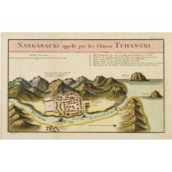
Nangasaki appellé par les Chinois Tchangki.
Attractive bird's-eye view of Nagasaki, with reference key to principal points of interest, including the Dutch V.O.C. Company House. The Dutch/Chinese enclave is central...
- $250 / ≈ €220
Place & Date: Paris, 1727
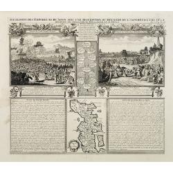
Succession Des Empereurs Du Japon Avec Une Description Du Meurtre De L'Empereur Cubo Et La Reception Des Ambassadeurs Hollandais En Ce Pays . . .
Composite sheet, with a small map of Japan and two detailed views: one depicting the murder of the Emperor Cubo, the other, the reception of the Dutch ambassadors, each w...
- $300 / ≈ €264
Place & Date: Amsterdam, 1728
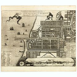
Plan de la Ville et du Chateau de Batavia en l'Isle de Iava / Ware affbeeldinge wegens het Casteel ende Stadt Batavia gelegen opt groot Eylant Java.
Detailed East-oriented plan of Jakarta former Batavia on Java / Indonesia. With bird's-eye view from sea side, various ships and a lion. Two inset keys with detailed desc...
Place & Date: Leiden, 1730
Selling price: $300
Sold in 2019

Imperii Persici in omnes suas Provincias . . . Exacte Divisi Nova Tabula Geographica. . .
Showing the eastern part of Turkey and Cyprus, Palestine, Persian Gulf, including Gulf of Oman, Caspian Sea, Iran and the north-west territories of India.Embellished with...
- $450 / ≈ €396
Place & Date: Ausburg, 1730
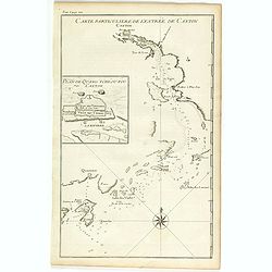
Carte particulière de l'entrée de Canton - Plan de Quang-tcheou-fou vulgo Canton .
Beautiful detailed map of the entrance to the city of Canton, showing also the cities of Macao and Quanghai, as well as the islands of the bay, including the island of Sh...
- $450 / ≈ €396
Place & Date: Paris, P.G. Le Mercier, 1735
Manuscript map of the Bay of Nagasaki.
An extremely rare manuscript chart in brown ink and wash color on a printed sheet of paper with a system of rhumblines and latitude scales. This chart shows the Bay of Na...
Place & Date: Amsterdam, 1750
Nieuwe kaart van Tartarie.
A map of Tartary, Korea and part of Japan. The map is most notable for the confusion between Kamchatka and Iesso.There are very good details of towns and trade routes in ...
Place & Date: Amsterdam, 1750
Constantinople ville de Romanie et capitale de l'Empire des Turcs.
A very decorative and extremely rare of Istanbul, including a numbered legend in lower part. Published by Jacques Chéreau, (1688 - 1776). Engraved by Aveline and first ...
Place & Date: Paris, ca.1750
Carte de la Turquie de L'Arabie et de la Perse.
This is the Amsterdam issue of De L'Isle's map of the Turkish Empire and Arabian Peninsula. It includes the Turkish Empire, the Mediterranean, Central Asia, and parts of ...
Place & Date: Amsterdam, 1751

Spatiosissimum Imperium Russiae Magnae juxta recentissimas Observationes Mappa Geographica . . .
This is a decorative map of greater Russia, extending from Livonia in the west to Kamchatka, China, Tibet, Taiwan, Korea, and part of Japan in the east. To the south, it ...
- $1300 / ≈ €1145
Place & Date: Augsburg, 1757

Plan de la ville de Madras et de ses attaques.
Manuscript map, in black, brown and red ink, showing the fortifications of the city of Madras, now Chennai, on the east coast of India, north of Pondicherry.Showing the c...
- $2000 / ≈ €1761
Place & Date: Paris, ca 1760
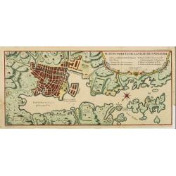
Plan du port et de la ville de Nangasaki.
This plan originates from Charlevoix's work Histoire et description Générele du Japon . His first in 1715 published work was the Histoire de l'etablissement du christia...
- $600 / ≈ €528
Place & Date: Paris, 1760
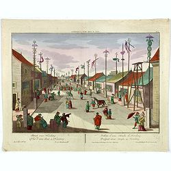
Vue d'une Rue Nanking.
A well-known publisher of optical prints, established in Augsburg. After a design by P.van Blankaert.In the eighteenth and nineteenth centuries, there were many popular s...
Place & Date: Augsburg 1760
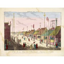
Vue de la Rue des Marchands Chinoises a Nankin.
So-called optical print illustrating a parade of vessels. Engraved by F.X. Habermann (1721-1796). The Academie Imperiale was a well-known publisher of optical prints, est...
- $450 / ≈ €396
Place & Date: Augsburg, 1760
![Plan de Gingy, ville et forteresse d'Asie . . . [An Early Manuscript Map of Pondicherry Prior To Its Reconstruction After The Seven Years War.]](/uploads/cache/43006-250x250.jpg)
Plan de Gingy, ville et forteresse d'Asie . . . [An Early Manuscript Map of Pondicherry Prior To Its Reconstruction After The Seven Years War.]
An early manuscript map of Gingy shortly after The Seven Years War, when the French took possession of large part of India.With an extensive key to the left.Gingee Fort o...
- $1500 / ≈ €1321
Place & Date: Paris, 1765

Plan de Thiagar, prise par l'arméé française en 1759.
An early manuscript map of Thiagar. With an extensive unfinished key to the left. The map was drawn shortly after the end of the Seven Years War, when the French took pos...
- $750 / ≈ €660
Place & Date: Paris, 1769
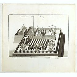
Observatoire de Peking.
The observatory of Mateo Rizzi in Peking, in which there are very large instruments, an Equinoctial Sphere, a Celestial Globe, a Zodiacal Sphere, Azimuthal Horizona, Quad...
- $200 / ≈ €176
Place & Date: Paris, GROSIER Jean-Baptiste, 1785
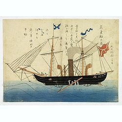
'Jokisen no zu' (Steamboat)
Nagasaki-e original Japanese woodblock print of a Steamboat. The figurehead is a striking detail.Nagasaki-e are Japanese woodblock prints that depict foreigners (Mostly ...
- $3750 / ≈ €3302
Place & Date: Nagasaki, c.1805
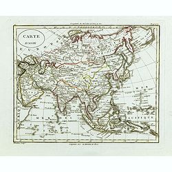
Carte d'Asie.
Fine map of Asia, with an interesting representation of Japan, Hokkaido, Sakhalin Island, Kamchatka, and Korea. Engraved by Alexandre Blondeau, who also worked for Depôt...
- $175 / ≈ €154
Place & Date: Paris, c. 1810
![Shintei Bankoku Zenzu [Revised Comprehensive Map of All Countries]](/uploads/cache/48437-250x250.jpg)
Shintei Bankoku Zenzu [Revised Comprehensive Map of All Countries]
Compiled by Kageyasu Takahashi, the finest world map of the Edo period, copper plate print, 1810. Bunka 7 is dated from the preface on this map,This world map, published ...
- $26000 / ≈ €22893
Place & Date: Kyoto, Bunka 7 or 1810
![Ansicht der stadt Nangasaky. [Nagasaki - title also in Russian characters]](/uploads/cache/24839-250x250.jpg)
Ansicht der stadt Nangasaky. [Nagasaki - title also in Russian characters]
A lively scene in Nagasaki harbor. In the foreground, Japanese junks and the town of Nagasaki in the background, with the warehouses on Deshima, the trading post of the D...
- $3000 / ≈ €2641
Place & Date: St.Petersburg, 1810-1814
![Ansicht des Papenbergs. [title also in russian]](/uploads/cache/24828-250x250.jpg)
Ansicht des Papenbergs. [title also in russian]
View at Takahoko at the mouth of Nagasaki Harbour. In center Papenberg known for Christian martyrs. In foreground Japanese junks and a Russian vessel. German title preced...
- $1500 / ≈ €1321
Place & Date: St.Petersberg, 1810-1814
![Ansicht von Megasaky. [Nagasaki - title also in Russian characters]](/uploads/cache/24829-250x250.jpg)
Ansicht von Megasaky. [Nagasaki - title also in Russian characters]
The print shows Nagasaki harbor with n the foreground the Russian delegation with Krusenstern in a boat with 3 Chinese. Japanese junks and the town of Nagasaki in the ba...
- $1500 / ≈ €1321
Place & Date: St.Petersburg, 1810-1814
La factorerie chinoise a nagasaki, dans la rue Teng-chan (fondée en 1688).
The Chinese traders at Nagasaki were confined to a walled compound which was located in the same vicinity as Dejima island; and the activities of the Chinese, though less...
- $500 / ≈ €440
Place & Date: Paris, A. Nepveu, 1820
![Das Fahrzeug auf welchem der Russische Gesandte zuert in Nangasaky ans Land fuhr. [Nagasaki]](/uploads/cache/24830-250x250.jpg)
Das Fahrzeug auf welchem der Russische Gesandte zuert in Nangasaky ans Land fuhr. [Nagasaki]
View of Nagasaki Harbour, with on foreground Japanese junks bringing the members of the first Russian expedition a shore. In the back ground the artificial island of Deji...
- $1750 / ≈ €1541
Place & Date: St.Petersburg, 1824
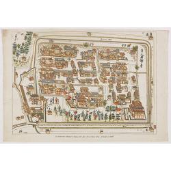
Plattegrond der Nederlandse Faktory op het Eiland Desima..
An uncommon Dutch bird's eye plan of Deshima, the Dutch trading post of the V.O.C., published in Isaac Titsingh's important Book on Japan "Bijzonderheden over Japan&...
Place & Date: 's-Gravenhage, widow of J. Allart, 1824-1825
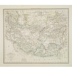
Perse Afghanistan et Balouchistan . . .
Detailed map of Irak and Iran, prepared by A. H. Basset, rue Saint-Jacques, no. 64, Paris and published in Atlas classique et Universel de Géographie . . . .The top thre...
Place & Date: Paris, A.H. Basset, 1828

A Chinese official with a ceremonial hat, holding a fan and a silk purse.
A colored wood block print of a Chinese official with a ceremonial hat, holding a fan and a silk purse.
Place & Date: Nagasaki, c. 1830
Macao.
Early view of Macao after Barthelemy Lauvergne (1805-1875) and engraved in aquatint technique by Sigismond Himely (1801-1872). Published as plate 28 in Voyage autour du m...
- $600 / ≈ €528
Place & Date: Paris, Finot, 1835

Carte physique et politique de l'Asie. Publiée pour la première fois en 1822 par J. GOUJON. Revue et augmentée par l'éditeur d'après de nouveaux matériaux.
This is a detailed map of Asie. It provides very good details of towns in modern-day Uzbekistan. The region is labeled as "Usbecs." The important cities on the...
- $500 / ≈ €440
Place & Date: Paris, J. Goujon et J. Andriveau, 1837

Orbis Veteribus Notus.
This is a detailed steel-engraved map of the ancient world, stretching from Europe eastwards to the Black Sea and beyond, southwards through northern Africa, Arabia, Indi...
Place & Date: London, 1839
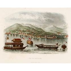
Vue de Nangasaki
View over the town from the water, identifying clearly Deshima with Japanese sloops in the fore ground. Engraved by Alp.Boilly.
- $120 / ≈ €106
Place & Date: Paris, 1842
Vue de Nangasaki
View over the town from the water, identifying clearly Deshima with the V.O.C. trading post. Japanese sloops in the fore ground. Engraved by Alp.Boilly.
- $180 / ≈ €158
Place & Date: Paris 1842
Vue de Nangasaki.
Steel engraved of Nagasaki from the water, identifying clearly Deshima, the V.O.C. trading post and the Dutch flag. Japanese and Chinese sloops in the fore ground. Engra...
- $125 / ≈ €110
Place & Date: Paris, 1842
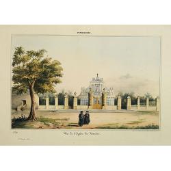
Pondichery - Vue de l'Eglise des Jésuites.
Lithography representing a view of a church belonging to the Jesuit order. Plate N° 11.From Souvenirs d'un voyage dans l'Inde, exécuté de 1834 à 1839, by A. Delessert...
- $300 / ≈ €264
Place & Date: Paris, 1843
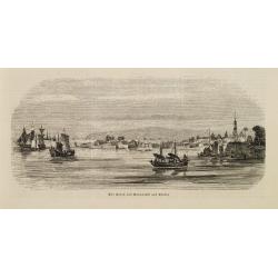
Der Hafen von Nangasaki auf Kiusiu.
A panoramic view of the harbour and city of Nagasaki with extensive shipping.
- $100 / ≈ €88
Place & Date: Germany, 1847
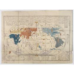
Chikyu Bankoku sankai yochi zenzu setsu. / Sekisui Cho Harutaka. (Map and description of geography of all the countries of the globe).
Reduced version of the famous map "Kaisei chikyu bankoku zenzu" by Sekisui Nagakubo (1717-1801) published ca. 1785, still based on the one by Matteo Ricci. Incl...
- $3500 / ≈ €3082
Place & Date: Tokyo, 1850
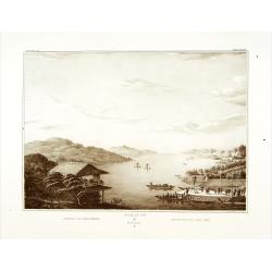
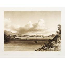
Gezicht op het Meer Tokaitç / Biwa-ko.
View of Lake Biwa near Kyoto.Von Siebold was born in Wurtzburg, in Germany, and worked for the Dutch government as a doctor in Java. In Japan, where Von Siebold arrived i...
- $1500 / ≈ €1321
Place & Date: Leiden, 1832-1852

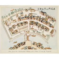
Nederlandsche Factory DEZIMA 1828.
Bird's-eye view of the manmade island of Deshima, a trading post of the V.O.C. from 1641 onward.Underneath the map a legend in Dutch and German with names of all the buil...
Place & Date: Leiden, 1832-1852
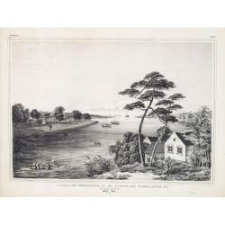
Factorij der Nederlanders op Firato.. 1609-1641.
Bird's-eye view of Hirado, a trading post of the V.O.C. from 1609 until 1641.Von Siebold was born in Wurzburg, in Germany, and worked for the Dutch government as a doctor...
- $1500 / ≈ €1321
Place & Date: Leiden, 1832-1852
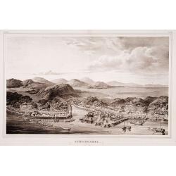
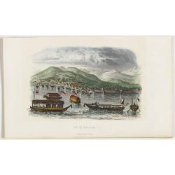
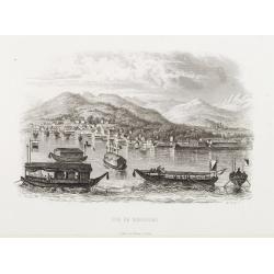
Simonoseki.
Bird's-eye view of Simonoseki, an important trading post in earlier times. Von Siebold was born in Wurtzburg, in Germany, and worked for the Dutch government as a doctor ...
- $1500 / ≈ €1321
Place & Date: Leiden, 1832-1852
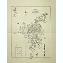
Insularum Japonicarum tabulae geographicae secundum opus NIPPON JO TSI RO TEI SEN TSU Tab. I Kiusui Insularum. . .
Fine map of the island if Kyushu, together with Tsushima Island with the bay of Nagasaki where in 1641 the man-made island of Deshima, trading post of the V.O.C. was est...
- $1000 / ≈ €880
Place & Date: Leiden, 1832-1852