Browse Listings in Atlases

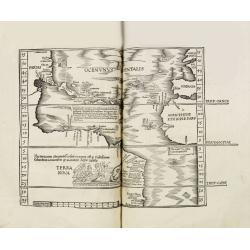
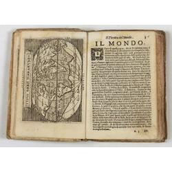
Strabonis illustrissimi scriptoris Geographia decem et septem libros continens.
First edition was published in Paris in the sixteenth century and the first with the preface by Thibaud Pigenat. Translation from Greek into Latin by Gregorio Tifernate a...
- $5000 / ≈ €4402
Place & Date: Paris, Hémon Le Fèvre, 1512
Claudii Ptolemaei geographicae enarrationis libri octo Bilibaldo Pirckeym hero interprete Annotationes Ioannis de Regio Monte in errores commissos a Iacobo Angelo in translatione sua.
This is a rare and interesting edition of Ptolemy's geography translated by Bilibaldo Pirckheym, accompanied by Regiomantus's annotations, and said to have been edited by...
- $59000 / ≈ €51949
Place & Date: Strassburg, Johann Grüninger, Johann Koberger, 1525
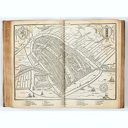
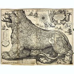
DESCRIPTION DE TOUT LE PAIS BAS Autrement dict La Germanie Inferieure, ou Basse-Allemaigne…
First French edition. Illustrated with a coat of arms and portrait of Philips II, with a folding map of The Netherlands and maps and views of Brabant, Louvain, Brussel, A...
- $4500 / ≈ €3962
Place & Date: Anvers. Guillaume Silvius, 1567
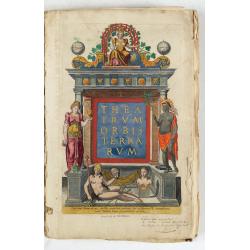
Theatrum Orbis Terrarum.
A Dutch edition of Ortelius' Theatrum Orbis Terrarum "Ghedruckt voor A. Ortelius" (by Corn. Claesz.?), 1598. Illustrated with 92 maps, 91 maps numbered 1-91, in...
- $100000 / ≈ €88050
Place & Date: (Amsterdam, Corn. Claesz.) ?, 1598

Le Nouveau miroir des voiages marins de la navigation de la mer occidentale & orientale.
A second and final French edition of this important sea atlas. Two engraved frontispieces, figure with volvelle, full-page figure, 48 double-page charts (one numbered 19....
- $120000 / ≈ €105660
Place & Date: Antwerp, Chez Iean Bellere, a l’Aigle d’or, l’An M.CCCCCC (1600
![Description de tovts les Pays-Bas, autrement appellez, la Germanie Inferieure, ov Basse Allemagne / par Messire Loys Gvicciardin [...]](/uploads/cache/48781-250x250.jpg)
Description de tovts les Pays-Bas, autrement appellez, la Germanie Inferieure, ov Basse Allemagne / par Messire Loys Gvicciardin [...]
Fine early edition of the French oblong edition of this famous description of the Low Countries. For the French edition most plates are newly engraved by Petrus Kaerius.....
- $3500 / ≈ €3082
Place & Date: Arnhem, Janssonius, J.,1613
Composite atlas of the Low Countries.
A unique, made-to-order atlas comprising 18 double-page engraved maps by or after Hessel Gerritsz, Theodoor Galle, Jacob van Deventer, Gerard Mercator, Peter Verbiest, Je...
Place & Date: [Antwerp, c. 1633

Itinerarium Sacrae Scripturae, dat is, Het Reysboeck der heyligher Schrift
This is a scarce 1648 Dutch edition of Büntings "Itinerarium Sacrae Scripturae" printed in Leeuwarden. The book includes 6 folding maps and 2 plates. The book ...
- $3000 / ≈ €2641
Place & Date: Leeuwarden, de Vries, Jan Jansz., 1648
Geographisches-Toneel, Of uitgezochte kaarten, Tot gemak der Officieren, Reisigers en Liefhebbers.
Pocket atlas, not in Koeman, but similar to Koeman III, p. 99 (Rat 1) of which our atlas is a later edition.Illustrated with 41 engraved maps, of which two are in origina...
- $2000 / ≈ €1761
Place & Date: Amsterdam, D. Weege, 1653
Theatro del Mondo di Abrahamo Ortelio..
Including maps of the world (Shirley, World 214): Europe; Asia; America (Burden, America 126, Marchetti 1598); Africa; England; Scotland; Ireland; Tercera; Spain (4); Por...
Place & Date: Venice, G. Turrini, 1655

L'Affrique En Plusieurs Cartes Nouvelles, et exactes, &c.
Edition illustrated with 18 maps in original outline colors dated 1656. No date and title page and maps not numbered (according to Pastoureau 1 C, maps are numbered).Nico...
Place & Date: Paris, l'Auteur, after 1662

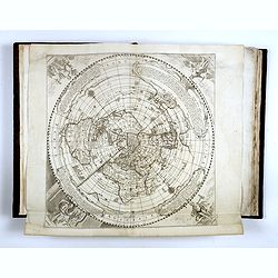
L’Atlas de la Mer ou Monde aquaticque.
Original blind-stamped vellum binding ; attractive ORIGINAL HAND-COLOR in outline with cartouches, windroses and decoration in full orginal color ; internally some usual ...
- $75000 / ≈ €66037
Place & Date: Amsterdam, sur le Cay de Teexel, prez du Rams-Koy, au miroir de la Mer, 1670

Petites tables Geneologiques touchant les droits et les interests des Princes.
Compilation of Duval's Pocket Atlas, with an archbishoprics and dioceses description of the world, here right at the beginning with the rare genealogical tables of variou...
- $3000 / ≈ €2641
Place & Date: Paris, P. Duval, ca. 1667-1672
French composite atlas made up of rare maps published by Parisian editors from the 17th century , mainly by G. Jollain including scarce maps of America.
A rare French composite atlas including 90 maps, published by Parisian publishers from the 17th century, mainly by Gérard I Jollain, or by maps bought from Dutch publish...
Place & Date: Paris, ca. 1675

Introductio in universam geographiam tam veterem, quám novam... et tabulis geographicis aucta studio & operâ Johannis Bunonis. . .
Engraved title with minor ink dash, title with former owner's signatures Joannes Steuchig, (could be the Swedish archbishop Johannes Steuchius (1676-1742). D. Hildebrand ...
- $3000 / ≈ €2641
Place & Date: Amsterdam, 1676
L'Amerique, en plusieurs cartes nouvelles, et exactes, &c. En divers traitez de geographie, et d'histoire. Là où sont descrits succinctement, & avec une belle Methode, & facile.
Third edition, the text and maps of which are identical to the first given in 1657. However, the dedication to Nicolas Fouquet (2 pp.), disgraced in 1661, has been delete...
- $4500 / ≈ €3962
Place & Date: Paris, 1680
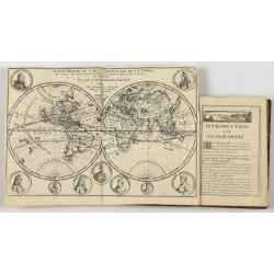
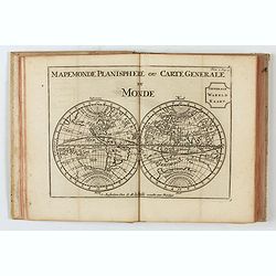
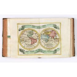
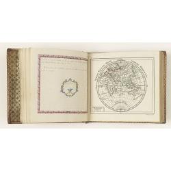
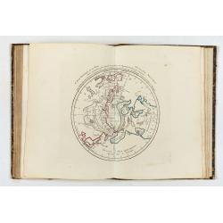
Introduction a la Geographie..
Second edition of this charming travel compendium illustrated with a fine world map in two hemispheres prepared by de l'Isle. California as an island. The hemispheres are...
- $2000 / ≈ €1761
Place & Date: Paris, 1717
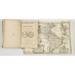
Introduction a la Geographie..
Second edition of this charming travel compendium illustrated with a fine world map in two hemispheres prepared by de l'Isle. California as an island. The hemispheres are...
- $2000 / ≈ €1761
Place & Date: Paris, 1717
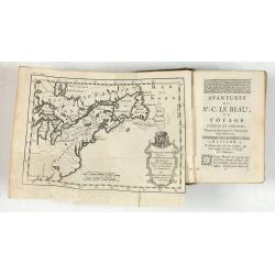
Avantures du Sr. C. Le Beau, avocat en parlement ou Voyage curieux et nouveau parmi les Sauvages de l'Amérique Septentrionale. Dans lequel on trouvera une Description du Canada… Ouvrage enrichi d'une Carte et des figures necessaires.
A description of Huron, Iroquois, and Algonquin customs, written in charming style and based, the Author claims, on observations made on a trip to America in 1729." ...
- $2500 / ≈ €2201
Place & Date: Amsterdam, 1738

Atlas van Zeevaert en Koophandel door de Geheele Weereldt.
Engraved frontispiece, title printed in red and black with engraved vignette, engraved dedication to the Dutch East India Company, 32 double-page engraved charts in very ...
- $50000 / ≈ €44025
Place & Date: Amsterdam, 1745

Atlas van Zeevaert en Koophandel door de Geheele Weereldt.
Engraved frontispiece, title printed in red and black with engraved vignette, engraved dedication to the Dutch East India Company, 32 double-page engraved charts with con...
- $65000 / ≈ €57232
Place & Date: Amsterdam, 1745
Le Théâtre du monde dédié au roi contenant les cartes générales et particulières des royaumes et états qui le composent.
The present example of the Théâtre du monde is the reissue of 1746 by Jean-Baptiste Nolin II. This scarce atlas is illustrated with 123 maps mostly double-page, in orig...
Place & Date: Paris, 1746

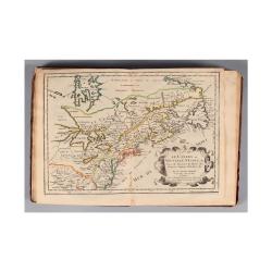
Comté d'Hollande, seigneurie d'Utrecht, comtés de Zelande, de Zutphen et duché de Brabant &c. Dressés sur les Mémoires faits par ordre des Estats Généraux et augmentés sur les Observations nouvelles.
Pocket atlas illustrated with a folded engraved title, a general map and 34 folded maps, including maps of the Netherlands, Belgium and parts of Germany.Provenance : Ex-l...
- $2400 / ≈ €2113
Place & Date: Paris, Crépy, ca. 1748
Der curiose und ... Nüssliche Dollmetscher..
Rare atlas and containing geographical descriptions of all continents. Illustrated with 30 very finely engraved and beautifully colored maps in attractive original strong...
- $6000 / ≈ €5283
Place & Date: Augsburg, 1748
Etrennes interessantes des quartre parties du monde..
A charming almanac for the year 1778. The maps are engraved by Durand et Le Roy, and each map has the name of the author Giovanni Antonio Battista Rizzi-Zannoni. This cha...
- $2500 / ≈ €2201
Place & Date: Paris, 1760

Etrennes Géographiques.
The leather binding has light wear and slight damage to the spine. The maps have very good impressions. Age-toning, occasional spotting, and soiling throughout. The margi...
- $450 / ≈ €396
Place & Date: Paris, 1761

Atlas Geographicus portatilis XXIX mappis orbis habitabilis
Fine pocket atlas containing a world and celestial map, further maps of the four continents and of European countries. The map of America has a blank coastline north to C...
- $2750 / ≈ €2421
Place & Date: Augsburg 1762

Histoire universelle depuis le commmencement du monde jusqu'a present. Tome Vingt-unieme. Portugais, Espagnols, Hollanois etc
Volume 21 of this informative publication with a description of the discoveries, conquests, and settlements by the Portuguese, Spaniards, English, and Dutch in Southeast ...
- $1200 / ≈ €1057
Place & Date: Amsterdam, Leipzig, 1763

Le Petit atlas maritime. Recueil de cartes et plans des quatre parties du monde, en cinq volumes.
FIRST EDITION. A large paper copy, in attractive original colors. Jacques Nicolas Bellin held offical status as royal hydrographer and ingéniuer géographe de la marine ...
- $45000 / ≈ €39622
Place & Date: Paris, 1764
Almanach géographique ou petit atlas élémentaire composé de Cartes générales et particulières des différens Empires, Royaumes et Républiques de l'Europe. . .
Charming almanac with two engraved dedication and title page, portrait of Christian VII. Roy de Dannemarck et de Norvège.The map of Asia is of interest for the use of Ko...
- $3000 / ≈ €2641
Place & Date: Paris, 1770

A view of the earth : being a short but comprehensive system of modern geography graphy ...
The Third Edition. First work with seven engraved maps (including a twin-hemisphere world map, continents), plate of a globe, engraved illustrations in the text including...
- $1750 / ≈ €1541
Place & Date: London, S. Crowder and S. Gamidge, 1771
Atlas general A L'Usage Des Colleges Et Maisons..
Rare atlas, published by Mondhare, maps dated 1780,1781 and 1793. Usually bright, attractive copy for a work of this kind. As announced in its title, this work was specif...
- $6000 / ≈ €5283
Place & Date: Paris, 1791
![Boertige reis door Europa. . . [with] Europa volgens de nieuwste verdeeling. . .](/uploads/cache/32642-250x250.jpg)
Boertige reis door Europa. . . [with] Europa volgens de nieuwste verdeeling. . .
Rare illustrated publication including a rare map of Europe as a regal queen with the title "Geheimzinnige toebereidselen tot eene boertige reis door Europa. [...] v...
- $2000 / ≈ €1761
Place & Date: Haarlem, 1794

A new and easy introduction to universal geography: In a series of letters to a youth at school. . . The ninth edition, improved and considerably enlarged.
This is the interesting ninth edition, with 26 full-page maps as called for in "Directions to the binder". The ninth edition was improved and considerably enlar...
Place & Date: London, 1800
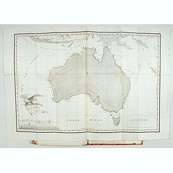
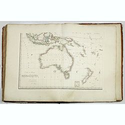
Voyage de découvertes aux Terres Australes. Historique. Atlas Deuxième partie.
First edition of the second part of the atlas by Freycinet, part of his important book "Voyage de découvertes aux Terres Australes". Illustrated with two foldi...
- $7500 / ≈ €6604
Place & Date: Paris, Langlois, 1811

Breves tratados de esfera y geografía universal, con algunas noticias históricas, en especial en lo perteneciente a España, para instruccion de la juventud.
Third edition of this popular Spanish Atlas for children, illustrated with 6 folding engraved "blind" maps, all finely colored by hand, in the main part in orig...
- $750 / ≈ €660
Place & Date: Madrid, Impreta de Collado, 1814
Grand atlas universel ou collection de cartes encyprotypes, générales et détaillées des cinq parties du monde.
Large folio atlas containing 8 general one-sheet maps, and 8 detailed four-sheet maps: Containing2 World maps- "Mappe-monde sur la projection de Mercator. Carte ency...
- $6000 / ≈ €5283
Place & Date: Paris, Desray, 1816

Neptune des Côtes Occidentales de France.
Large maritime atlas illustrated with a handwritten title, a table and 47 single or double page charts. The charts show the western coasts of France as well as the Spanis...
- $12000 / ≈ €10566
Place & Date: Paris, 1776-1822

Geographie Universelle dite de Crozat.
A nice geographical dictionary with maps of the world and the continents and maps of European countries. Mappemonde, l'Europe, les provinces United des Pays Bas, Allem...
Place & Date: Paris, 1823
![The Cerographic Missionary Atlas. [Imprint inside front cover:] Entered according to Act of Congress, in the year 1848, By Se. E. Morse & Co.,....](/uploads/cache/41699-250x250.jpg)
The Cerographic Missionary Atlas. [Imprint inside front cover:] Entered according to Act of Congress, in the year 1848, By Se. E. Morse & Co.,....
An unusually and quite early American atlas of areas where missionary activity was being, or could be conducted. Including two global hemispheres showing North and South ...
- $1250 / ≈ €1101
Place & Date: New York, 1848

J.Horsburgh/ R.H.Bate / G.H.Stapleton. The two chart books are bound in contemp. half calf, and include together 57 of the most up-to-date French (Depot général de la marine) and English (Hydrographic Office) charts available in 1847 for sailing t
BOOK 1 : Mainly charts by "Dépôt Général de la Marine" including 20 folding charts. The binding measuring 665x275mm, the charts mostly 595x910mm.1. Dépôt ...
- $50000 / ≈ €44025
Place & Date: Paris, London, Hong Kong, 1835 - 1849

内務省地理局 (Administratif atlas of the Empire of Japan.)
Atlas of Japan published by the Home Ministry shortly after the start of Meiji period. The atlas contains 16 double page maps, with the border in original out line colors...
- $550 / ≈ €484
Place & Date: Tokyo, Meiji 14 or 1881

Atlas des Missions Catholiques.
Vingt cartes teintées, avec texte explicatif par R. P. O. Werner de la Compagnie de Jésus. Traduit de l’Allemand, revu et augmenté par M. Valérien Groffier, auteur ...
- $1000 / ≈ €880
Place & Date: Lyon, 1886

The Royal Primrose Atlas. 'A Complete Desk Companion & Blotter Combining The Most Interesting And Up-To-Date Maps ...
Contains 17 maps, an introduction plus various diagrams and statistics throughout. End pages consist of promotional material for John Knight Ltd. (Est. 1817) Manufacturer...
Place & Date: London, ca. 1914