Browse Listings in America > North America > Western America / Texas
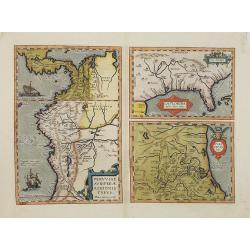
La Florida/ Peruviae Auriferae regionis Typus/ Guastecan.
The Chaves map of Florida is a prime example of an explorer's map since it records the recent discoveries of Cabeza de Vaca, De Soto, and Moscoso. The map revealed little...
- $1400 / ≈ €1233
Place & Date: Antwerp, 1592

Dutton Map of the Grand Canyon, Arizona (in 4 joined sheets)
An important 1882 map of the Grand Canyon, Arizona, published in "Atlas To Accompany The Monograph On The Tertiary History Of The Grand Canon District By Capt. Clare...
- $1000 / ≈ €880
Place & Date: Julius Bien & Co., 1882
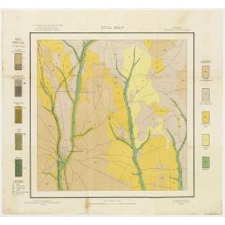
Soil map - Texas, Nacogdoches sheet.
Early color lithographed soil map by Julius Bien & Co. in New York for Department of Agriculture. Legends at side give detail on soil type, etc. They also include int...
- $75 / ≈ €66
Place & Date: New York, 1903
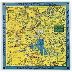
The Famous Hysterical Map of Yellowstone Park, including a few minor Changes.
A lovely whimsical map of America's Yellowstone Park, published about the time of President Franklin Roosevelt's "New Deal" for America in 1936. To emphasise th...
- $450 / ≈ €396
Place & Date: America, ca 1936
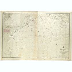
Gulf of Mexico. Ship Shoal to Brazos Santiago.
A large sea chart of the Gulf of Mexico, Ship Shoal to Brazos Santiago, 'from Admiralty Charts and US Government charts, corrected to 1943'. (In fact there are correction...
- $200 / ≈ €176
Place & Date: London, 1943 updated to 1951