Browse Listings in America > North America > North America
![[Moose].](/uploads/cache/40180-250x250.jpg)
[Moose].
Scarce print (150x177mm.) of a Moose on a German text sheet taken from a first edition of Johann Ludwig Gottfried's "Newe Welt Vnd Americanische Historien/ Jnhaltend...
- $100 / ≈ €88
Place & Date: Frankfurt, M.Merian, 1633
![[American history plate].](/uploads/cache/40176-250x250.jpg)
[American history plate].
Scarce print (150x177mm.) on a German text sheet taken from a first edition of Johann Ludwig Gottfried's "Newe Welt Vnd Americanische Historien/ Jnhaltende Warhaffti...
- $80 / ≈ €70
Place & Date: Frankfurt, M.Merian, 1633

Americque Septentrionale. . .
A general map of North America shows California as an island but with few names and a flat northern coastline. Prepared by N. Sanson and engraved by A.Peyrounin. A first ...
- $1000 / ≈ €880
Place & Date: Paris, P. Marriete, 1667
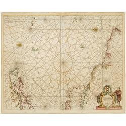
Pascaerte van Carybes, Nieu Neder landt, Brazil. . .
This progenitor chart covers the American shores of the Atlantic Ocean. This chart by Theunis Jacobsz. was most probably engraved close to his death in 1650 or shortly af...
- $2200 / ≈ €1937
Place & Date: Amsterdam, 1653-1681

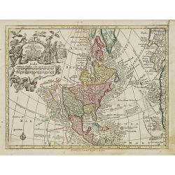
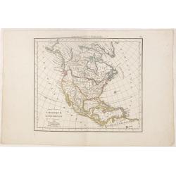
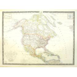
Amerique Septentrionalis..
This handsome map shows California as an island, open-ended Great Lakes, and other details based mainly on Sanson. A large decorative cartouche occupies the area of the n...
Place & Date: Paris, after1694

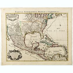
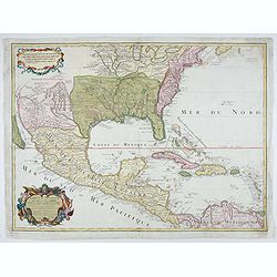
Carte du Mexique et de la Floride des Terres Angloises et des Isles Antilles...
Scarce state not listed by Tooley with the imprint : "Chez l’Auteur sur le Quai de l’Horloge a la Cour.r de Diamãs. Avec Privilege du Roy po.r 20 ans, 1703"...
- $3000 / ≈ €2641
Place & Date: Paris, 1703
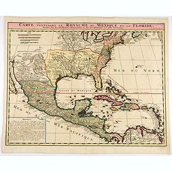
Carte contenant le Royaume du Mexique et la Floride.
This is a derivative of Delisle's landmark map of the southern part of North America.The detailed map shows many English settlements along the East Coast and carefully no...
- $1000 / ≈ €880
Place & Date: Amsterdam, 1719

Carte contenant le Royaume du Mexique et la Floride.
This is a derivative of Delisle's landmark map of the southern part of North America. The detailed map shows many English settlements along the East Coast and carefully n...
- $900 / ≈ €792
Place & Date: Amsterdam, 1719
Carte du Mexique et de la Floride, des terres angloises et des isles Antilles, du cours et des environs de la rivière Mississipi. . .
A Dutch edition of De L'Isle's map. It was the first printed map to portray accurately the course and mouth of the Mississippi River. Showing the explorations of d'Ibervi...
Place & Date: Amsterdam, 1722

Carte qui contient..Iles & Terres..L'Amerique..Jamaique..
Eight maps on one sheet. From Chatelain's Atlas Historique et Méthodique . Including maps of Bermuda, Jamaica, New England with Long Island, Carolina, Chesapeake and Del...
Place & Date: Amsterdam, 1728
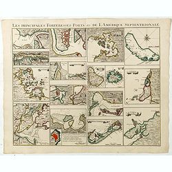
Les Principales Forteresses Ports &c de L'Amérique Septentrionale. . .
This sheet contains 19 small but detailed maps and plans of harbours, towns, forts and islands from the eastern seaboard and the West Indies, all but one plan with title ...
Place & Date: Amsterdam, 1733
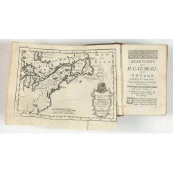
Avantures du Sr. C. Le Beau, avocat en parlement ou Voyage curieux et nouveau parmi les Sauvages de l'Amérique Septentrionale. Dans lequel on trouvera une Description du Canada… Ouvrage enrichi d'une Carte et des figures necessaires.
A description of Huron, Iroquois, and Algonquin customs, written in charming style and based, the Author claims, on observations made on a trip to America in 1729." ...
- $2500 / ≈ €2201
Place & Date: Amsterdam, 1738

L'Amerique septentrionale, Dressée sur les memoires les plus recens. . .
A very detailed map extending from Hudsons Bay to Panama, and including the West Indies. The map is a later copy of Guillaume de L'Isle's foundation map of North America,...
Place & Date: Amsterdam, 1739
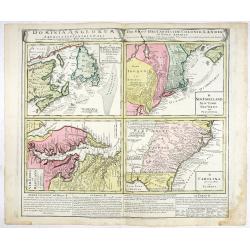
Dominia Anglorum in America Septentrionali.
Four maps on one sheet (New Found land/ New England/ Virginia and Carolina/Florida) based on J.B.Homann's map, showing British possessions in North America. The upper lef...
- $750 / ≈ €660
Place & Date: Nuremberg 1740

Amérique Septentrionale. . .
A fine small map of North America, extending from Hudsons' Bay to Panama, and including the West Indies. Dated 1748.From Atlas Portatif Universel, by Robert de Vaugondy.P...
- $200 / ≈ €176
Place & Date: Paris, later than 1748
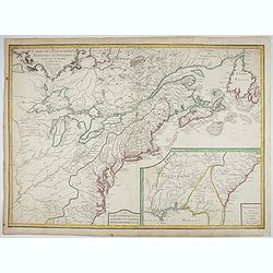
Carte des Possessions Françoises et Angloises dans le Canada, et partie de la Louisiane.
First state of this separately published map of the European Colonies in the New World east of the Mississippi River. This map was published in 1756 to provide informatio...
Place & Date: Paris, 1756
L'Amerique septentrionale, Dressée sur les memoires les plus recens. . . MDCCLVII
A rare map of North America, showing good detail, especially in the region between the Appalachians and the Mississippi and the course o the Mississippi to its source, wh...
- $1500 / ≈ €1321
Place & Date: Amsterdam, 1757

America Septentrionalis, Concinnata juxta Observationes..
This exemplar represents Lotter's version of Delisle's foundation map of North America, published in 1700. The Great Lakes show the French strong holds at Quebec, Montrea...
- $875 / ≈ €770
Place & Date: Augsburg, ca. 1770
Nov' Orbis Sive America Septentrionalis. . .
Miniature map of North America, a reduction of the appropriate part of Seutter's folio map of the Americas, drawn by Albert Seutter. An unusual looking map, its projectio...
- $250 / ≈ €220
Place & Date: Augsburg, J.M.Will, 1778
Carte du Mexique et des Etats Unis d'Amérique…
A later edition of De l'Isle's foundation map of 1703, widely regarded as one of the most influential maps in the history of American Cartography. This updated version o...
Place & Date: Paris, 1783

Die Vereinigten Staaten von Nord Amerika..
Uncommon map of the east coast of North America, including the Great Lakes area. To the right inset map of New Foundland. After the map by William Faden of 1783. With col...
- $500 / ≈ €440
Place & Date: Germany, 1790
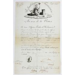
Passeport.
Passport for the United States in the name of Madeleine Lavit Femme Lory, issued by the Commission of Interior Relations and approved by the Committee of Public Safety.Th...
- $750 / ≈ €660
Place & Date: Paris, 1795
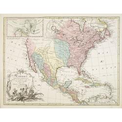
Nouvelle Espagne, Nouveau Méxique, Isles Antilles, par Robert de Vaugondy corrigés par le Cen. Lamarche Géog. Successeur de Vaugondy. l''An 3e.
Although dated 1794/95 [l'An 3e.], the map is a copy of an earlier map which appeared in Robert de Vaugondy's 1778 atlas. Hence, it does not show the newly independent Un...
- $300 / ≈ €264
Place & Date: Paris, 1794 - 1806

Gedeelte van den Vereenigden Staat van Noord Amerika.
A rare an detailed map of the eastern part of the United States of America. After Isaac Weld's map from his Travels through the States of North America 1799. Barbara Back...
- $650 / ≈ €572
Place & Date: Netherlands c. 1820
Amérique septentrionale.
A fine map of North America published by the well-known Paris publisher of maps, globes and atlases C.F. Delamarche.
- $110 / ≈ €97
Place & Date: Paris, 1824

Danse d'indiens.
From Giulio Ferrario's work Le Costume ancien et moderne ou histoire du gouvernement, de la milice, de la religion, des arts, etc. published in Milan by the author betwee...
- $50 / ≈ €44
Place & Date: Milan, 1827
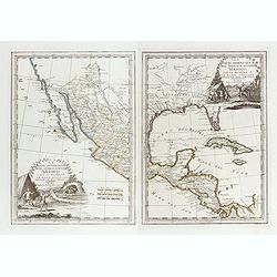
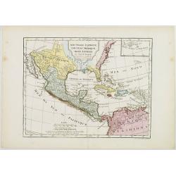
La parte orientale dell' antico.. messico con la Florida..
A splendid two-sheet map of Mexico, including California, Arizona, New Mexico, part of Texas, Baja California and Mexico (west part) and of the Southeast Part of the US, ...
Place & Date: Rome, Calcography, 1797-before 1839
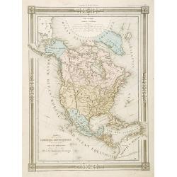
Carte L'Amérique Septentrionale..
Detailed map of North America, prepared by J.G.Barbié du Bocage.Engraved by Ch.Smith, published by Basset who was established in Paris, rue de Seine 33.
- $100 / ≈ €88
Place & Date: Paris, 1848
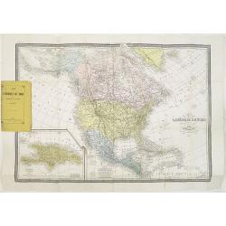
Carte de L'Amérique du Nord. . .
Detailed map of Nord America and Central America giving good detail along the east coast and the Lakes. Including San Francisco, Monterey, etc.With inset map of Dominican...
- $250 / ≈ €220
Place & Date: Paris, 1870
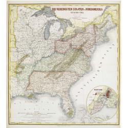
Die Vereinigten Staten von Nordamerika (Ostlicher theil).
Detailed map of eastern part of the United states until the border of Texas. In lower right hand corner inset map of New York Bay, including, NY, Newark, Staten Island.Th...
- $450 / ≈ €396
Place & Date: Weimar, 1874
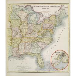
Die Vereinigten Staten von Nordamerika (Ostlicher theil).
Detailed map of eastern part of the United states. In lower right hand corner inset map of New York Bay, including, NY, Newark, Staten Island.The map is prepared by C.Gr�...
- $450 / ≈ €396
Place & Date: Weimar, 1874
Nouvelle carte de l'Amérique Septentrionale et des iles qui en dépendent dressée par H. Brué. . .
Very large, highly detailed, and uncommon issue of the map of North and Central America (ca. 1:13,888,000) prepared by H. Brué and improved by A.Vuillemin. Showing main ...
- $500 / ≈ €440
Place & Date: Paris, 1875

Map showing the cotton growing belt in the United States Prepared for and copyrighted by Geo. H.Mc.Fadden & Bro., cotton merchands based in Phiiladelphia, USA 1892.
A rare map showing the cotton-growing Belts in the Southern States for 1892. Prepared for and copyrighted by Geo. H. Mc.Fadden & Bro., cotton merchants based in Phila...
- $1000 / ≈ €880
Place & Date: Philadelphia, 1892

Alabama. Official Highway map 1942.
Folding road map of Alabama. Published in Montgomery, Alabama by Paragon Press. Mileage chart and six city plans in margin; verso includes text and photos. Scale [ca. 1:8...
- $100 / ≈ €88
Place & Date: Alabama, Paragon Press, 1942