Browse Listings in America > North America
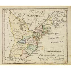
Die Vereinigten Staaten von Nord-Amerika.
Nice little German map of the early United States. The only state shown west of the Appalachian Mountains is Kentucky. Above which is a strangely shaped unnamed region (O...
- $250 / ≈ €220
Place & Date: Augsburg, 1812

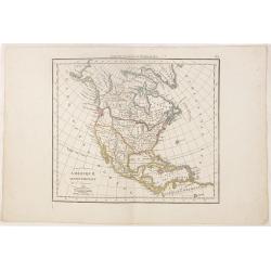
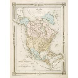
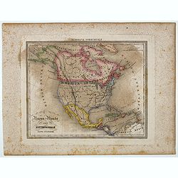
Carte d' Amérique Septentrionale 1817.
Map of North and Central America. Engraved by E.Collin, active at 23, quai des Augustins, Paris.
- $300 / ≈ €264
Place & Date: Paris, 1817
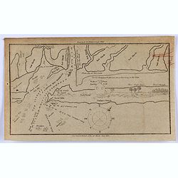
Little Egg Harbour.
A small sea chart showing Little Egg Harbour east of Tucker's Island. This map was published in the “American Coast Pilot”, a detailed guide to harbors, capes and hea...
- $50 / ≈ €44
Place & Date: New York, 1817
![Etats-Unis de L'Amerique Septentrionale. [Two sheets in manuscript ]](/uploads/cache/03972-250x250.jpg)
Etats-Unis de L'Amerique Septentrionale. [Two sheets in manuscript ]
Two sheets giving an detailed information in French, about population in the year 1810, principal cities, products of industry and commerce, financial situation for the y...
- $2000 / ≈ €1761
Place & Date: France, ca. 1819

Gedeelte van den Vereenigden Staat van Noord Amerika.
A rare an detailed map of the eastern part of the United States of America. After Isaac Weld's map from his Travels through the States of North America 1799. Barbara Back...
- $650 / ≈ €572
Place & Date: Netherlands c. 1820
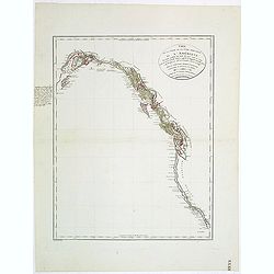
Carte de la partie de la cote nord-ouest de l'Amerique. Reconnue pendant les Etes de 1792, 1793 et 1794 depuis 29054' de latitude nord et 244033' de. . .
Detailed and rare map of the Gulf of Alaska, British Columbia, south to St.Francisco.Prepared by Edward Roberts after information by George Vancouver. Engraved by Tardieu...
Place & Date: Paris, 1820
Selling price: $150
Sold in 2011
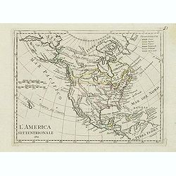
L'America septentrionale.
Charming and finely engraved map of North America from the rare atlas Atlante Tascabile o sia Serie di Num. XXI Cartine Geografiche nelle quali si rappresenta in ristrett...
- $275 / ≈ €242
Place & Date: Rome, 1823
Amérique septentrionale.
A fine map of North America published by the well-known Paris publisher of maps, globes and atlases C.F. Delamarche.
- $110 / ≈ €97
Place & Date: Paris, 1824

System of Penal Law, prepared for the State of Louisiana , comprising codes of offenses and punishments, of procedure, of prison discipline, and of evidence applicable as well to civil as to criminal cases.
The "Enquiries" of Rush and Bradford and the Pennsylvania movement toward abolition of the death penalty had a little immediate impact on the practices of other...
- $2500 / ≈ €2201
Place & Date: New-Orleans, Benjamin Levy, 1824
![Carte Géographique [ . . .] de la Pensylvanie.](/uploads/cache/14221-250x250.jpg)
Carte Géographique [ . . .] de la Pensylvanie.
Detailed map of Pennsylvania. From J.A. Buchon, Atlas Gégraphique Statistique, historique et chronologique des deux Amériques et des isles adjacentes. traduit de l'atla...
- $250 / ≈ €220
Place & Date: Paris, 1825
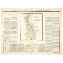
Carte Géographique .. Delaware.
Detailed map of Delaware. From J.A. Buchon, Atlas Gégraphique Statistique, historique et chronologique des deux Ameriques et des isles adjacentes, traduit de l'atlas ex�...
- $300 / ≈ €264
Place & Date: Paris, 1825

Carte Géographique .. Vermont.
Detailed map of Vermont. From J.A. Buchon, Atlas Gégraphique Statistique, historique et chronologique des deux Amériques et des isles adjacentes: traduit de l'atlas ex�...
- $250 / ≈ €220
Place & Date: Paris, 1825
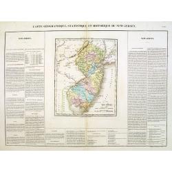
Carte Géographique .. New Jersey.
Detailed map of New Jersey. From J.A. Buchon, Atlas Gégraphique Statistique, historique et chronologique des deux Amériques et des isles adjacentes: traduit de l'atlas ...
- $300 / ≈ €264
Place & Date: Paris, 1825

Carte de l'Amerique septentrionale Rédigée par A.H.Brué géographe.
Detailed dissected folding-map of North and Central America by Brué, originally published in Atlas Universel but here mounted on linen and intersected in 8 parts. Next t...
- $250 / ≈ €220
Place & Date: Paris, 1825

Carte Géographique, statistique et historique du Rhode Island.
Detailed map of Rhode Island. From J.A. Buchon, Atlas Gégraphique Statistique, historique et chronologique des deux Amériques et des isles adjacentes, traduit de l'atla...
- $175 / ≈ €154
Place & Date: Paris, 1825
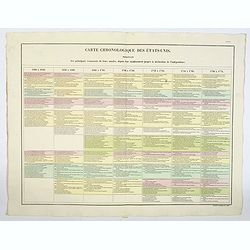
Carte Chronologiquedes Etats-Unis.
A hand colored historical timeline table (in French), highlighting "the main [historical] events in the years from their establishment to the declaration of independ...
- $100 / ≈ €88
Place & Date: Paris, 1825

Pantographie de l'Histoire d'Amerique, ou Description de la situation relative des etats et colonies de l'Amerique. . .
An attractivelooking hand colored historical timeline table (in French), charting important historical events and discoveries of America and their States and Colonies sin...
- $100 / ≈ €88
Place & Date: Paris, 1825

Carte Geographique, Statistique ey Historique du Maryland.
A lovely, detailed map of Maryland, from Buchon's, Atlas Gégraphique Statistique, historique et chronologique des deux Ameriques et des isles adjacentes, traduit de l'at...
- $100 / ≈ €88
Place & Date: Paris, 1825

Carte Geographique, Statistique ey Historique du District de Colombie.
A lovely, detailed map of the District of Columbia, (Washington) from Buchon's, Atlas Gégraphique Statistique, historique et chronologique des deux Ameriques et des isle...
- $100 / ≈ €88
Place & Date: Paris, 1825

Carte Geographique, Statistique et Historique du New Hampshire.
A detailed map of New Hampshire, from Buchon's Atlas Gégraphique Statistique, historique et chronologique des deux Ameriques et des isles adjacentes, traduit de l'atlas ...
Place & Date: Paris, 1825
Selling price: $50
Sold in 2019

Carte Geographique, Statistique et Historique de Massachusetts.
A detailed map of Massachusetts, from Buchon's Atlas Gégraphique Statistique, historique et chronologique des deux Ameriques et des isles adjacentes, traduit de l'atlas ...
- $100 / ≈ €88
Place & Date: Paris, 1825

Carte Geographique, Statistique et Historique du Delaware.
A nice detailed map of Delaware, from Buchon's Atlas Gégraphique Statistique, historique et chronologique des deux Ameriques et des isles adjacentes, traduit de l'atlas ...
- $100 / ≈ €88
Place & Date: Paris, 1825

Carte Geographique, Statistique et Historique du New York.
A detailed map of State of New York, from Buchon's Atlas Gégraphique Statistique, historique et chronologique des deux Ameriques et des isles adjacentes, traduit de l'at...
- $100 / ≈ €88
Place & Date: Paris, 1825
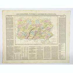
Carte Géographique, Statistique et Historique de la Pensylvanie.
A detailed map of Pennsylvania, from Buchon's Atlas Gégraphique Statistique, historique et chronologique des deux Amériques et des isles adjacentes, traduit de l'atlas ...
- $100 / ≈ €88
Place & Date: Paris, 1825
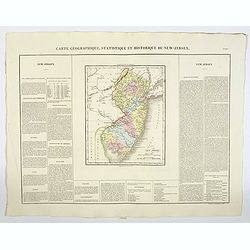
Carte Géographique, Statistique et Historique du New-Jersey.
A detailed map of New Jersey, from Buchon's Atlas Gégraphique Statistique, historique et chronologique des deux Amériques et des isles adjacentes: traduit de l'atlas ex...
Place & Date: Paris, 1825
Selling price: $50
Sold in 2019

Missions et Résidences dans la Partie Septentrionale de l'Amérique Contenant 50 Jésuites.
Very rare missionary map of North America from "Atlas Universel indiquant les établissemens des Jésuites: avec la manière dont ils divisent la terre, suivi desév...
- $300 / ≈ €264
Place & Date: Paris, Ambroise Dupont , 1826

Danse d'indiens.
From Giulio Ferrario's work Le Costume ancien et moderne ou histoire du gouvernement, de la milice, de la religion, des arts, etc. published in Milan by the author betwee...
- $50 / ≈ €44
Place & Date: Milan, 1827

Les Aleuts.
From Giulio Ferrario's work Le Costume ancien et moderne ou histoire du gouvernement, de la milice, de la religion, des arts, etc. published in Milan by the author betwee...
- $50 / ≈ €44
Place & Date: Milan, 1827

Portrait de Benjamin Franklin.
Portrait de Benjamin Franklin. From Giulio Ferrario's work Le Costume ancien et moderne ou histoire du gouvernement, de la milice, de la religion, des arts, etc. publishe...
- $75 / ≈ €66
Place & Date: Milan, 1827
![[Foggia di vestive degli Abitanti del Porto dei Francesi.' [Alaska-North American Indians].](/uploads/cache/44730-250x250.jpg)
[Foggia di vestive degli Abitanti del Porto dei Francesi.' [Alaska-North American Indians].
Aquatint depicting a tribe meeting engraved by A.T Biasioli, Plate N° 13. : 'Foggia di vestive degli Abitanti del Porto dei Francesi.' showing Alaska-North American Indi...
- $90 / ≈ €79
Place & Date: Milan, 1827
![[Native Americans of village at Nootka Sound].](/uploads/cache/44726-250x250.jpg)
[Native Americans of village at Nootka Sound].
Aquatint depicting people in a Nootka Sound village engraved by A.D Rossi, Plate N° 12 From Giulio Ferrario's work Le Costume Ancien et Moderne ou Histoire du gouverneme...
Place & Date: Milan, 1827
![[No title]. [Alaska-North American village with boats].](/uploads/cache/44728-250x250.jpg)
[No title]. [Alaska-North American village with boats].
Aquatint depicting a fishing scene engraved by Paolo Fumagalli, Plate N° 20 From Giulio Ferrario's work Le Costume Ancien et Moderne ou Histoire du gouvernement, de la m...
Place & Date: Milan, 1827
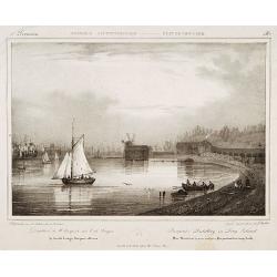
Pierpont's distillery on Long Island.
Decorative print after Jacques Milbert, and lithographed by Sabatier and the figures by Victor Adam.From Amérique Septentrionale. Printed by E.Ardit, Rue Vivienne, Paris...
Place & Date: Paris, 1829
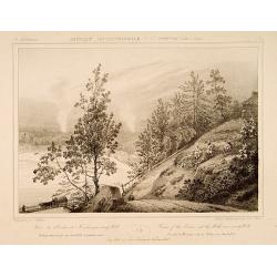
Course of the Hudson and the Millsnear Sandy Hill.
Decorative print after a design of Jacques Milbert, and lithographed by Sabatier, showing the River Hudson with the falls near Sandy Hill.From Amérique Septentrionale. P...
- $150 / ≈ €132
Place & Date: Paris, 1829
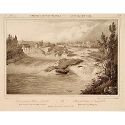
Falls of the Hudson at Sandy Hill.
Decorative print of the Falls on the river Hudson near Sandy Hill, after Jacques Milbert, and lithographed by Bichbois and the figures by Victor Adam.An outstanding view ...
- $150 / ≈ €132
Place & Date: Paris, 1829
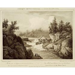
Saw Mill near Luzerne source of the Hudson.
Decorative print of Saw Mill near Lucerne, Warren County, after Jacques Milbert, and lithographed by Bichebois.Printed by de Bove and Noöl ainé &Cie. An outstanding...
- $150 / ≈ €132
Place & Date: Paris 1829
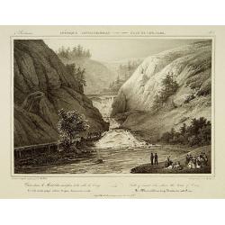
Falls of mount Ida, above the town of Troy.
Decorative print after Jacques Milbert, and lithographed by Bichbois, Showing the Water Falls of mount Ida, above the town of Troy.From Amérique Septentrionale. Printed ...
- $150 / ≈ €132
Place & Date: Paris, 1829
![Town of Hudson. . . [title in French, English, German & Latin] N°11. Pl. 3.](/uploads/cache/26653-250x250.jpg)
Town of Hudson. . . [title in French, English, German & Latin] N°11. Pl. 3.
The town of Hudson.From 3e Livraison Amérique Septentrionale - Etat de New York. After Jacques Milbert and lithographed by L. Sabatier, the figures by V. Adam. Printed b...
- $150 / ≈ €132
Place & Date: Paris, Bove dirigée par Nöel ainé & Cie, 1829
![Falls on the Flint River . . [title in French, English, German & Latin] N°33. Pl. 1.](/uploads/cache/26801-250x250.jpg)
Falls on the Flint River . . [title in French, English, German & Latin] N°33. Pl. 1.
A view of the Flint River Falls.From 9e Livraison Amérique Septentrionale - Etat de New York. After Jacques Milbert and lithographed by Deroy. Printed by E. Ardit, rue V...
- $150 / ≈ €132
Place & Date: Paris, Bove dirigée par Nöel ainé & Cie, 1829
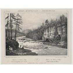
![Hudson Fall at the village of Gleens. . . [title in French, English, German & Latin] N°22. Pl. 2.](/uploads/cache/26656-250x250.jpg)
Hudson Fall at the village of Gleens. . . [title in French, English, German & Latin] N°22. Pl. 2.
A view of the Hudson Fall at the village of Gleens.From 6e Livraison Amérique Septentrionale - Etat de New York. After Jacques Milbert and lithographed by Tirpenne. Prin...
- $150 / ≈ €132
Place & Date: Paris, Bove dirigée par Nöel ainé & Cie, 1829
Lake George and the village of Caldwell. . . N°24.
A view of Lake George and the village of Caldwell.From 6e Livraison Amérique Septentrionale - Etat de New York. After Jacques Milbert and lithographed by L. Sabatier, th...
- $150 / ≈ €132
Place & Date: Paris, E. Ardit, 1829
![Extremity of Adley's Falls. . . [title in French, English, German & Latin] N°27. Pl. 3.](/uploads/cache/26659-250x250.jpg)
Extremity of Adley's Falls. . . [title in French, English, German & Latin] N°27. Pl. 3.
A view of the extremity of Adley's Falls..From 7e Livraison Amérique Septentrionale - Etat de New York. After Jacques Milbert and lithographed by L. Sabatier. Printed by...
- $120 / ≈ €106
Place & Date: Paris, E. Ardit, 1829
Bridge on the Hudson River near Luzerne. . . N°25. Pl. 1.
A view of a bridge on the Hudson River near Luzerne. .From 7e Livraison Amérique Septentrionale - Etat de New York. After Jacques Milbert and lithographed by Bichebois. ...
- $120 / ≈ €106
Place & Date: Paris, Henri Gaugain & Cie, 1829
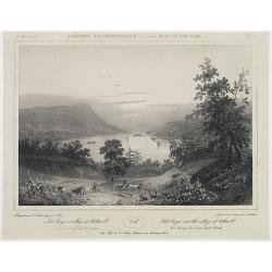
General view of the Hudson at Adley's. . . N°29.
A panoramic view of the Hudson River at Adley's.From 8e Livraison Amérique Septentrionale - Etat de New York. After Jacques Milbert and lithographed by Jacottet, the fig...
- $120 / ≈ €106
Place & Date: Paris, Henri Gaugain & Cie, 1829
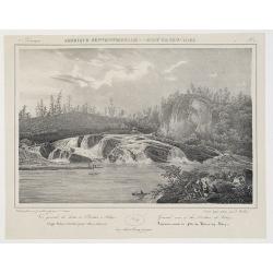
![[Waterfall in New York State] Pl. 2.](/uploads/cache/26821-250x250.jpg)
[Waterfall in New York State] Pl. 2.
View of a waterfall.An outstanding view most probably from Milbert's Itinéraire pittoresque du fleuve Hudson et des parties latérales de l'Amérique du Nord.Milbert arr...
- $100 / ≈ €88
Place & Date: Paris, Bove dirigée par Nöel ainé & Cie, 1829
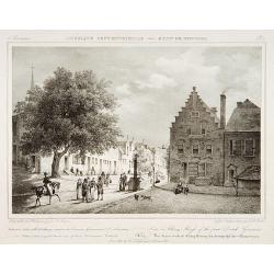
View in Albany-House of the first Dutch Governors.
Decorative print after Jacques Milbert, and lithographed by Tierpenne and the figures by Victor Adam.From Amérique Septentrionale. Printed by de Bove and Noöl ainé &am...
- $250 / ≈ €220
Place & Date: Paris, 1829
![[Lake George and the village of Caldwell.]](/uploads/cache/26087-250x250.jpg)
[Lake George and the village of Caldwell.]
A proof state without the text of Lake George and the village of Caldwell after Jacques Milbert, and lithographed by Sabartier.From Amérique Septentrionale. Printed by H...
- $100 / ≈ €88
Place & Date: Paris, 1829
![[ Road and Bridge over the Mohawk ].](/uploads/cache/26088-250x250.jpg)
[ Road and Bridge over the Mohawk ].
Uncommon proof state without the text of Road and Bridge over the Mohawk after Jacques Milbert, and lithographed by Sabartier.From Amérique Septentrionale. Printed by He...
- $150 / ≈ €132
Place & Date: Paris, 1829
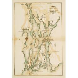
Plan of part of RHODE ISLAND..
Map showing vicinity around New Port. It Shows American and British armies at the siege of Newport and the subsequent action on the 29th of August 1778. Depicting the Fre...
- $100 / ≈ €88
Place & Date: Philadelphia, 1806 or 1834
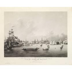
Vue du Port de Boston. View of the Port of Boston.
Superb aquatint of Boston harbor. Painted by L. Garneray and engraved by Himely. Published by Hocquart in Paris and Bailly Ward and Co. of New York.Second state with the...
- $2200 / ≈ €1937
Place & Date: Paris, ca. 1834
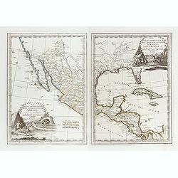
La parte orientale dell' antico.. messico con la Florida..
A splendid two-sheet map of Mexico, including California, Arizona, New Mexico, part of Texas, Baja California and Mexico (west part) and of the Southeast Part of the US, ...
Place & Date: Rome, Calcography, 1797-before 1839
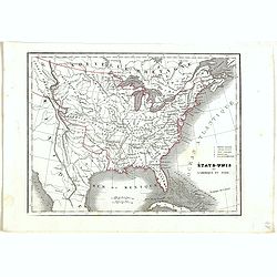
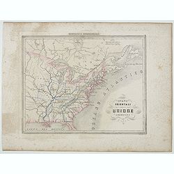
Etats-Unis de l'Amérique du nord.
Detailed map of North America, prepared by Charles V. Monin (fl.1830-1880) a French cartographer of Caen and Paris. Published in Atlas Universel de Géographie Ancienne &...
- $75 / ≈ €66
Place & Date: Paris, 1845
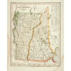
Neueste Karte von New Hampshire und Vermont.
Detailed map of New Hampshire and Vermont with numerous physical and political features including mines, settlements, trails/roads, forts and Indian areas. From Meijers H...
- $150 / ≈ €132
Place & Date: Hildburghausen/ Philadelphia, 1846
Carte L'Amérique Septentrionale..
Detailed map of North America, prepared by J.G.Barbié du Bocage.Engraved by Ch.Smith, published by Basset who was established in Paris, rue de Seine 33.
- $100 / ≈ €88
Place & Date: Paris, 1848

New York von der Seeseite aus gesehen.
Very decorate view of New-York. J.Hesse was known as a portrait painter and publisher of lithographs. A long panorama of the shoreline from the sea, with sailing vessels ...
- $700 / ≈ €616
Place & Date: Berlin, c. 1850
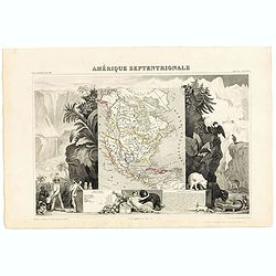
Amerique Septentrionale.
Beautiful map with the United States extending into present day Canada, Russia in control of Alaska and Mexico's northern border according to the Treaty of 1810. Surround...
- $175 / ≈ €154
Place & Date: Paris, A. Combette, 1852
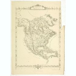
North America.
Map of North America, published by "The London Printing and Publishing Company". Drawn and engraved by John Rapkin.
- $100 / ≈ €88
Place & Date: London, 1854
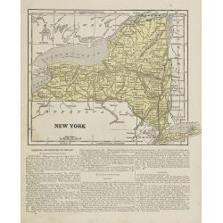
New York.
Map of New York. From Sidney E. Morse''s: System of Geography for the use of schools , published by Harper and brothers, 329 Pearl Street, New York.An 150 years old map w...
- $30 / ≈ €26
Place & Date: New York, 1855
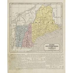
Maine, New Hampshire and Vermont.
Map of Maine, New Hampshire and Vermont.. On the verso, a world map of North and South America with its northern and southern hemispheres. From Sidney E. Morse''s: System...
- $30 / ≈ €26
Place & Date: New York, 1855
Nuovo Mondo parte Settentrionale.
Uncommon map of North America prepared by Francesco Costantino Marmocchi. Above the map "Geografia Commerciale". From "Il Globo Atlante di carte Geografich...
- $50 / ≈ €44
Place & Date: Genova, Paolo Rivara fu Giacomo, 1858
Stati Orientali della Unione Americana.
Uncommon map of Northeastern America prepared by Francesco Costantino Marmocchi. Above the map "Geografia Commerciale". From "Il Globo Atlante di carte Geo...
- $50 / ≈ €44
Place & Date: Genova, Paolo Rivara fu Giacomo, 1858
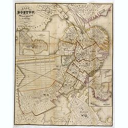
Plan Of Boston Comprising a Part of Charlestown and Cambridge. Published by George G. Smith, Engraver, Washington Street Boston 1855..
Important and detailed plan of Boston, with insets :"Plan Of East Boston from actual Survey by R.H. Eddy" and "Plan Of South Boston From a Drawing by S.P. ...
- $1250 / ≈ €1101
Place & Date: Boston, ca. 1859

Een Danser der Californische Indiaanen.
Decorative, original hand colored, woodcut engraving illustrating a native American dancer from California.
- $35 / ≈ €31
Place & Date: Amsterdam, ca. 1860

Town of Yonkers Westchester Co. NY
Fine lithographed map of the town of Yonkers. The map provides the names of specific homeowners, as well as information about the occupations and physical locations of th...
- $150 / ≈ €132
Place & Date: New York, 1867
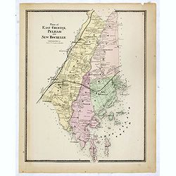
Plans of East Chester Pleham and New Rochelle. Westchester Co.
Fine lithographed map of East Chester Pelham and New Rochelle. The map provides the names of specific homeowners, as well as information about the occupations and physica...
- $100 / ≈ €88
Place & Date: New York, 1867
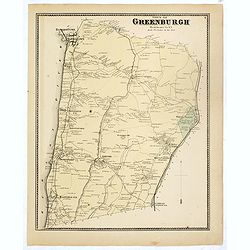
Town of Greenburgh.
Fine lithographed map of the town of Greenburgh. The map provides the names of specific homeowners, as well as information about the occupations and physical locations of...
- $100 / ≈ €88
Place & Date: New York, 1867

White Plains.
Fine lithographed map of White Plains. The map provides the names of specific homeowners, as well as information about the occupations and physical locations of the vario...
- $125 / ≈ €110
Place & Date: New York, 1867

Town of Mt Pleasant. Westchester Co. NY.
Fine lithographed map of the town of Mt Pleasant. The map provides the names of specific homeowners, as well as information about the occupations and physical locations o...
- $100 / ≈ €88
Place & Date: New York, 1867

Town of North Castle.
Fine lithographed map of the town of North Castle. The map provides the names of specific homeowners, as well as information about the occupations and physical locations ...
- $100 / ≈ €88
Place & Date: New York, 1867
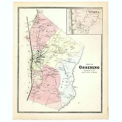
Town of Ossining. Westchester Co. NY.
Fine lithographed map of the town of Ossining. The map provides the names of specific homeowners, as well as information about the occupations and physical locations of t...
- $100 / ≈ €88
Place & Date: New York, 1867
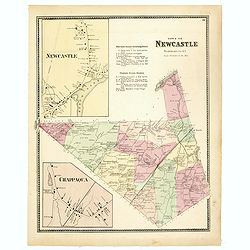
Town of New Castle. Westchester Co. NY.
Fine lithographed map of the town of New Castle. The map provides the names of specific homeowners, as well as information about the occupations and physical locations of...
- $100 / ≈ €88
Place & Date: New York, 1867

Mount Kisco / Bedford / Katonah / Bedford Station.
Fine lithographed map of Mount Kisco / Bedford / Katonah / Bedford Station. The map provides the names of specific homeowners, as well as information about the occupation...
- $100 / ≈ €88
Place & Date: New York, 1867

Town of Cortlandt.
Fine lithographed map of the town of Cortlandt. The map provides the names of specific homeowners, as well as information about the occupations and physical locations of ...
- $90 / ≈ €79
Place & Date: New York, 1867

Town of Verplanck / Crugers / Croton Landing.
Fine lithographed map of the town of Verplanck / Crugers / Croton Landing. The map provides the names of specific homeowners, as well as information about the occupations...
- $90 / ≈ €79
Place & Date: New York, 1867
Town of Yorktown.
Fine lithographed map of the town of Yorktown. The map provides the names of specific homeowners, as well as information about the occupations and physical locations of t...
- $90 / ≈ €79
Place & Date: New York, 1867

Town of Somers.
Fine lithographed map of the town of Somers. The map provides the names of specific homeowners, as well as information about the occupations and physical locations of the...
- $90 / ≈ €79
Place & Date: New York, 1867

Town of North Salem.
Fine lithographed map of the town of North Salem. The map provides the names of specific homeowners, as well as information about the occupations and physical locations o...
- $90 / ≈ €79
Place & Date: New York, 1867
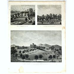
Property of F.A.Halstead Bedford Station, The Halstead Homestead at Bedford and Inland Vale residence of J.S.Libby, Westchester Co. NY North Salem.
Three heliographic prints on one sheet : "Property of F.A.Halstead Bedford Station", "The Halstead Homestead at Bedford" and "Inland Vale residen...
- $100 / ≈ €88
Place & Date: New York, 1867
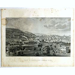
View of Brewsters' Putnam Co.N.Y.
Heliographic print of Brewsters' Putnam Co.N.Y." after a design by R.K.Sneden.From Beer's famous county atlas "Atlas of New York and vicinity, a documentary rec...
- $100 / ≈ €88
Place & Date: New York,1867
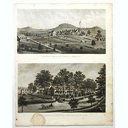
Résidence of WM H.Drew Southeast Putnam Co.N.Y / Lake Farm Résidence of John V.Storm East Fiskill Dutches Co.N.Y.
Two heliographic prints on one sheet : " Résidence of WM H.Drew Southeast Putnam Co.N.Y / Lake Farm Résidence of John V.Storm East Fiskill Dutches Co.N.Y." af...
- $100 / ≈ €88
Place & Date: New York,1867