Browse Listings in America > Central America > Central America
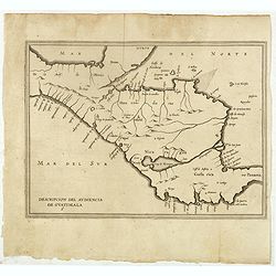
Descripcion del audiencia de Guatimala 6
The earliest map to include information from the previously secret manuscript maps of the Spanish cosmographer, Juan López de Velasco, showing part of Central America, i...
- $400 / ≈ €352
Place & Date: Amsterdam, Michel Colin, 1622
![[Nicaraguan's dancing.]](/uploads/cache/40361-250x250.jpg)
[Nicaraguan's dancing.]
Each province organized its own festivities and people would come to a place of open land therein, which had been swept clean for dancing. The dancers were accompanied by...
- $100 / ≈ €88
Place & Date: Frankfurt, M.Merian, 1633
![[How the Indians cured the Spanish thirst for gold....by pouring it down their throats!]](/uploads/cache/40483-250x250.jpg)
[How the Indians cured the Spanish thirst for gold....by pouring it down their throats!]
A brutal scene depicting native Indians tying down Spanish men and pouring liquid gold down their throats. Scenes of cannibalism in the background.In 1631 Johann Ludwig G...
Place & Date: Frankfurt, M.Merian, 1633

Nova Hispaniae, Chili, Peruviae, et Guatimalae Littorae..
A superbly decorative chart, oriented with north to the left of the sheet, covering the coasts of Central America, Peru, Chile, Jamaica and part of Cuba and Porto Rico. S...
- $1000 / ≈ €880
Place & Date: Amsterdam, 1660

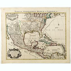
Carte contenant le Royaume du Mexique et la Floride.
This is a derivative of Delisle's landmark map of the southern part of North America. The detailed map shows many English settlements along the East Coast and carefully n...
- $900 / ≈ €792
Place & Date: Amsterdam, 1719

Carte Particuliere de Isthmus ou Darien qui Comprend le Golfe de Panama &c. Cartagena, et les Isles aux Environs.
Finely executed map of a portion of Central America, extending from the East Coast of Nicaragua and Costa Rica in the northwest to Cartagena and Santa Martha in modern Co...
- $1250 / ≈ €1101
Place & Date: Amsterdam, 1720
Carte du Mexique et de la Floride, des terres angloises et des isles Antilles, du cours et des environs de la rivière Mississipi. . .
A Dutch edition of De L'Isle's map. It was the first printed map to portray accurately the course and mouth of the Mississippi River. Showing the explorations of d'Ibervi...
Place & Date: Amsterdam, 1722

L'Amerique septentrionale, Dressée sur les memoires les plus recens. . .
A very detailed map extending from Hudsons Bay to Panama, and including the West Indies. The map is a later copy of Guillaume de L'Isle's foundation map of North America,...
Place & Date: Amsterdam, 1739
L'Amerique septentrionale, Dressée sur les memoires les plus recens. . . MDCCLVII
A rare map of North America, showing good detail, especially in the region between the Appalachians and the Mississippi and the course o the Mississippi to its source, wh...
- $1500 / ≈ €1321
Place & Date: Amsterdam, 1757

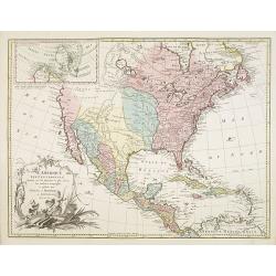
America Septentrionalis, Concinnata juxta Observationes..
This exemplar represents Lotter's version of Delisle's foundation map of North America, published in 1700. The Great Lakes show the French strong holds at Quebec, Montrea...
- $875 / ≈ €770
Place & Date: Augsburg, ca. 1770

L'Ancien et le nouveau Mexique avec la Floride..
Covering Florida, Texas, western part of Cuba and central America. Showing dozens (100+) of place names, extensive river systems, mountain ranges and featuring the Gulf o...
Place & Date: Paris, 1781

Guayane, Terre Ferme Isles Antilles. . .
Map showing Mexico, Cuba, Central America. Left and right a box with geographical information for each part country on the continent.Prepared by Louis Brion de la Tour an...
- $200 / ≈ €176
Place & Date: Paris, 1790

Le Indie Ocidentali ( Antille maggiori e minori, ecc) L'America Centrale . . .
Uncommon map of Central America and the Antilles prepared by Francesco Costantino Marmocchi. Above the map "Geografia Commerciale". From "Il Globo Atlante ...
Place & Date: Genova, Paolo Rivara fu Giacomo, 1858