Browse Listings in America

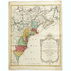
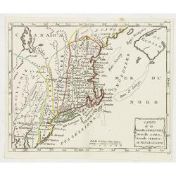
Carte de la Nouvelle Angleterre, Nouvelle York et Pensilvanie / Pour servir à l'Histoire Générale des Voyages.
Uncommon edition of this accurate map the east coast from Delaware River till Main.Left hand corner Lake Ontario. In lower right engraved "38."From Atlas Portat...
- $275 / ≈ €242
Place & Date: Amsterdam, 1773

Vue de la Rade et de la Ville de Paramaribo.
A very decorative panoramic view of the town with a large Dutch vessel in the foreground. Engraved by Noach van der Meer Junior. Included in a Dutch edition of "Hist...
- $200 / ≈ €176
Place & Date: Amsterdam, 1774
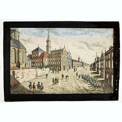
![Prospect des Plazes vor dem Rath Haus zu Boston. Vuë de la Rue et de la Maison de Ville a Boston. [together with] Prospect der König[lichen] ...](/uploads/cache/34214-250x250.jpg)
Prospect des Plazes vor dem Rath Haus zu Boston. Vuë de la Rue et de la Maison de Ville a Boston. [together with] Prospect der König[lichen] ...
Two so-called optical prints show a decorative imaginary view of the old state house, built in 1657, which was the center of government for the colony of Massachusetts an...
- $1500 / ≈ €1321
Place & Date: Augsburg, ca. 1776
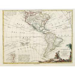
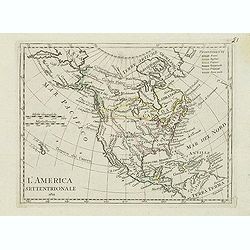
L'America divisa ne suoi principali Stati..
Attractive map of The Americas, with the first voyage of Capt. Cook (1768) depicted around South America and across the Pacific to New Zealand, which is well charted. Nor...
Place & Date: Venice, 1776
Selling price: $500
Sold in 2017
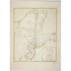
![[Upper sheet map only] The Provinces New York, and New Jersey with part of Pensilvania and the Province of Quebec.](/uploads/cache/25624-250x250.jpg)
[Upper sheet map only] The Provinces New York, and New Jersey with part of Pensilvania and the Province of Quebec.
Rare separately issued map, unfortunately only the upper part of the map. It is a variant of this important colonial map. The upper sheet showing the upper course of the ...
- $750 / ≈ €660
Place & Date: Frankfurt, 1777
Carte nouvelle de l'Amérique angloise contenant tout ce que les Anglois possèdent. . . avec la Floride / gravée. . . par Maththias Albert Lotter. . .
As mentioned in the title piece, the map includes the area at that time in the possession of the English, i.e. Canada, New Large, beautiful and detailed map of the Easter...
Place & Date: Augsburg, 1777

Carte de la Dominique Prise par les Francois le 7 Septembre 1778. Avec le Plan du Debarquement et de l'Attaque des Forts et Batteries par les Troupes et Les Fregates de sa Majeste
A rare map of St. Dominica, with insets of Charlotteville with its attack by the French on 7 September 1778 on the British. Also small inset map of the Caribbean islands ...
- $500 / ≈ €440
Place & Date: Paris, 1778

Parte Orientale della Florida, della Giorgia, e Carolina. . .
Attractive map covering the coast from S.Augustine till Long Bay, including Jacksonville, Savannah. From Zatta's Atlante Novissimo.
- $350 / ≈ €308
Place & Date: Venice, 1778
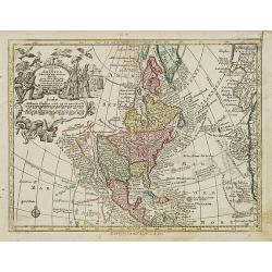
Nov' Orbis Sive America Septentrionalis. . .
Miniature map of North America, a reduction of the appropriate part of Seutter's folio map of the Americas, drawn by Albert Seutter. An unusual looking map, its projectio...
- $250 / ≈ €220
Place & Date: Augsburg, J.M.Will, 1778

Carte des troubles De L'Amerique Levée par Ordre du Chevalier Tryon. . . New-York.. Jersey..
A French edition of this uncommon Revolutionary War map describes the region from Salem Massachusetts to Buzzard's Bay south to the Delaware River and west to Lake Ontari...
- $1500 / ≈ €1321
Place & Date: Paris, 1778
La Baja D'Hudson Terra di Labrador e Groenlandia.
Decorative map of Nova Scotia, Hudson Bay and part of Greenland. With many names of villages, as well engraved mountains and rivers are shown.Published in Zatta's "A...
- $300 / ≈ €264
Place & Date: Venice, 1778
Mappa Geographica provinciae Nova.. NEW-YORK..
This map afforded British commanders during the Revolution an excellent overview of areas that would be crucial in the early years of the war, in particular the Hudson Va...
- $1500 / ≈ €1321
Place & Date: Nuremburg, 1778
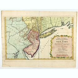
Mappa geographica Provinciæ Nova Eboraci ab Anglis New-York . . .
Lower part of the two sheets map of Homann Heirs' edition of Sauthier's celebrated map of New York and New Jersey, made during the Revolutionary War. Appears in Homann's ...
Place & Date: Nuremburg, 1778

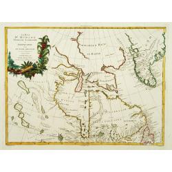
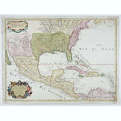
Carte du Mexique et de la Nouvelle Espagne..
Santini's version of D'Anville's important map shows the south-eastern part of the United States, Mexico and the Gulf of Mexico. Tecas is named as Nouv'le Leon. La Salle'...
- $500 / ≈ €440
Place & Date: Venice 1779
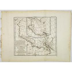
Carte de la Californie et des Pays Nord-Ouest. . . 4de Carte.
Diderot's famous 2 on 1 map shows the two early mappings of the west coast of North America, the first after Visscher, the second after Plancius' World map. Both show the...
- $200 / ≈ €176
Place & Date: Paris, 1779
Carte de la Nouvelle Angleterre, Nouvelle York, Nouvelle Jersey, et Pensilvanie.
Highly detailed regional map of the Northeastern US, featuring numerous place names, Forts, Native American tribes, rivers,coastal banks, and other details. This is a Fre...
- $250 / ≈ €220
Place & Date: Paris, 1780
Prospect der Strasse gegen der Kirche der Recolecten in der obern Stadt zu Quebec. Vuë de la Rue des Recolets dans la haute Ville de Quebec.
A so-called optical print showing a decorative imaginary town view of Québec, with a street view with soldiers marching and pedestrians, an idealized view depicting Qué...
- $450 / ≈ €396
Place & Date: Augsburg, ca. 1780

Prospect des Haupt Plazes der Untern Stadt zu Quebec.
A so-called optical print showing a decorative imaginary town view of Québec, with a street view with soldiers marching and pedestrians, an idealized view depicting Qué...
- $500 / ≈ €440
Place & Date: Augsburg, ca.1780

L'America meridionale divisa nei suoi principali stati.
Rare map of south America, from "Atlante Novissimo ad uso Dei Giovani Studiosi Contenuto In Carte XXVII.", published by Giovanni Zempel in Rome, ca. 1780.The ma...
- $100 / ≈ €88
Place & Date: Rome, 1780

L'Ancien et le nouveau Mexique avec la Floride..
Covering Florida, Texas, western part of Cuba and central America. Showing dozens (100+) of place names, extensive river systems, mountain ranges and featuring the Gulf o...
Place & Date: Paris, 1781

Golfe du Mexique Assujetti aux Observations Astronomiques Par J.B.Nolin.
Rare map of the Caribbean prepared by J.B.Nolin and published by L.J. Mondhare for his Atlas Général a l'usage des colleges et maisons d'education.. Louis Joseph Mondha...
- $200 / ≈ €176
Place & Date: Paris, 1781

Carte du Bresil le Perou. . .
Scarce map of Northern part of South America with Venezuela, Colombia, Brazil and Peru, prepared by Nolin and published by L.J. Mondhare for his Atlas Général a l'usage...
- $125 / ≈ €110
Place & Date: Paris, 1781

L'Amerique Septentrionale Divisee en Ses Principaux Etats. . .
Engraved by Lattré. This map is most notable for its depiction of Mer de L'Quest or Sea of the West, near modern-day Seattle. A great sea, easily the size of the Mediter...
- $400 / ≈ €352
Place & Date: Paris, 1782
L' Amerique divisée par Grands Etats. . .
Attractive map of America, ornated with a decorative title cartouche. Boundaries outlined in hand color.Prepared by Le Sieur Janvier, Jean denis [Robert], French geograph...
- $450 / ≈ €396
Place & Date: Paris, ca 1783
L'Amérique suivant les dernier. . .
Scarce map of America, prepared by Nolin and published by L.J. Mondhare for his Atlas Général a l'usage des colleges et maisons d'education.. Louis Joseph Mondhare was ...
- $200 / ≈ €176
Place & Date: Paris, 1783
Carte du Mexique et des Etats Unis d'Amérique...
A later edition of De l'Isle's foundation map of 1703, widely regarded as one of the most influential maps in the history of American Cartography. This updated version of...
Place & Date: Paris, 1783
Carte du Mexique et des Etats Unis d'Amérique…
A later edition of De l'Isle's foundation map of 1703, widely regarded as one of the most influential maps in the history of American Cartography. This updated version o...
Place & Date: Paris, 1783

Carte Générale du Canada, de la Louisiane, de la Floride, de la Caroline..
Map of the eastern part of the United States and Canada. With inset map of Hudson and Baffin bays. in the lower right corner.Venetian edition of d'Anville's map, from &qu...
- $750 / ≈ €660
Place & Date: Venice, 1776 - 1784

Partie Méridionale de la Louisiane, avec la Floride, la Caroline et la Virginie..
Fine map of southeastern part of the United States after d'Anville's, to whom Santini gives credit in the cartouche.It covers the Atlantic coastline between the Chesapeak...
Place & Date: Venice, 1776 - 1784
Selling price: $1500
Sold in 2008

Messico ouvero Nuova Spagna che contiene Il Nuova Messico La California con una Parte de Paesi Adjacenti. . .
Decorative and detailed map of Mexico, Texas, Florida, Louisiana, and Central America. The map is filled with remarkable detail throughout, particularly in Texas, New Mex...
- $475 / ≈ €418
Place & Date: Venise, 1785

ETATS-UNIS DE L'AMÉRIQUE SEPTENTRIONALE Avec LES ISLES ROYALE, DE TERRE NEUVE, DE S.T JEAN, L'ACADIE, &c. 1785. Supplement a l'Atlas de M. Robert de Vaugondy a Paris Ches Boudet Ingenieur du Roi.
A map of the eastern United States with "Supplément à l'atlas de M Robert de Vaugondy à Paris chez Boudet Imprimeur du Roi", in place of the attribution to D...
- $1750 / ≈ €1541
Place & Date: Paris, 1785

Amérique Septentrionale .. Les Etats Unis..
Very rare state: probably separately issued. Published the same year the Treaty of Paris was signed, this is one of the first maps to provide printed boundary lines for t...
- $3000 / ≈ €2641
Place & Date: Paris, 1786

AMERIQUE SEPTENTRIONALE dressée sur les Relations les plus modernes des Voyageurs et Navigateurs ou se remarquent LES ETATS UNIS. . .
This large map of North America and the West Indies was originally published in 1750: however after the Treaty of Paris recognized the United States in 1783 the map was '...
Place & Date: Paris, after 1786
Selling price: $750
Sold in 2011

Karte von den N.W. Amerikanischen und N.OE. Asiatischen Kusten nach den Untersuchungen des Kapit. Cook...
A detailed large-scale map showing the Bering Strait, Kamchatka, Alaska and much of North America. While the Russian coastline is shown with reasonable accuracy. Showin...
- $450 / ≈ €396
Place & Date: Vienna, 1788
L'Amérique divisée en ses principaux Etats Dressée d'après les Cartes de Mr. Bonne?
Rare, wall map of America in 2 sheets, after R. Bonne. With 3 inset maps of Hispaniola, Martinique and Hudson Bay. Beautiful title cartouche depicting a Native American l...
Place & Date: Paris, 1788

Karte von den N.W. Amerikanische und N.O.E. Asia. . .
German edition of Cook's explorations along the NW Coast of America and NE Coast of Asia, based upon the original work by Lieutenant Henry Roberts.A detailed large-scale ...
- $400 / ≈ €352
Place & Date: Vienna, 1788

Karte von den N.W.Amerikanische und N.O.E. Asia..
A detailed large-scale map showing the Bering strait, Kamchatka, Alaska, and much of North America. While the Russian coastline is shown with reasonable accuracy. Showing...
- $500 / ≈ €440
Place & Date: Vienna 1788

Karte der Magellanischen-Strasse. . .
Very detailed map of Strait of Magellan, with in top inset map of Southern tip of South America with the Falklands. Prepared by Don Juan de La Cruz of Spain.Engraved by J...
- $600 / ≈ €528
Place & Date: Vienna, 1789

Guayane, Terre Ferme Isles Antilles. . .
Map showing Mexico, Cuba, Central America. Left and right a box with geographical information for each part country on the continent.Prepared by Louis Brion de la Tour an...
- $200 / ≈ €176
Place & Date: Paris, 1790
![[North America]](/uploads/cache/25907-250x250.jpg)
[North America]
Uncommon map of North America. The young United States incorporates the upper Midwest, with the remaining western territories of Louisiana, Nouveau Mexique, Nouveau Albio...
- $1000 / ≈ €880
Place & Date: Augsburg, ca. 1790

L'Amerique selon l'Etendue de Ses Principales Parties et don't les Points Principaux. . .
Uncommon map of South America, decorated with an elaborate cartouche referring to the conversion of the natives to Christianity, with natives bowing to a figure holding a...
- $600 / ≈ €528
Place & Date: Augsburg, ca. 1790

Uomo del Paraguai nell' America Meridionalle. / Homme du Paraguai dans l'Amerique Meridionalle.
Full portrait of a Paraguayan hunter. From "Raccolta di ? stampe." a series of historically significant eighteenth-century copper plate engravings by Venetian e...
- $250 / ≈ €220
Place & Date: Venice, Antonio Zatta, c.1790

Indiana del Perù. / Indienne du Perou.
Portrait of a Peruvian Indian woman holding a fruit basket and a lama in background. From "Raccolta di ? stampe." a series of historically significant eighteent...
- $300 / ≈ €264
Place & Date: Venice, Antonio Zatta, c.1790

Dona del Regno di Granata. / Femme du Roy.me de Granade.
Full portrait of a woman from Grenada region is situated on Lake Nicaragua. From "Raccolta di ? stampe." a series of historically significant eighteenth-century...
- $250 / ≈ €220
Place & Date: Venice, Antonio Zatta, c.1790

Uomo del Canale di Noël della terra del Fuoco, nel Mar Australe. / Homme du Canal de Noël de la terre de Feu dans la Mer Australe.
Full portrait of a man from the Tierra del Fuego. From "Raccolta di ? stampe." a series of historically significant eighteenth-century copper plate engravings b...
- $250 / ≈ €220
Place & Date: Venice, Antonio Zatta, c.1790

Donna dell' Isola di Pasqua, o terra di Davis nel Mar del Sud. / Femme de l' Isle de Pâques ou terre de Davis dans la Mer du Sud.
Full portrait of a woman, a native of the Easter Island. From "Raccolta di ? stampe." a series of historically significant eighteenth-century copper plate engra...
- $350 / ≈ €308
Place & Date: Venice, Antonio Zatta, c.1790

Uomo dell' Isola di Pasqua o Terra di Davis nel Mar del Sud. / Homme de l' Isle de Pâquesou Terra de Davis dans la Mer du Sud.
Full portrait of a native from the Easter Island. From "Raccolta di ? stampe." a series of historically significant eighteenth-century copper plate engravings b...
- $300 / ≈ €264
Place & Date: Venice, Antonio Zatta, c.1790
L' Amerique dressée pour l'étude de la géographie . . .
Map showing the American continent. California with a large inlet. Some major cities, bodies of water, and geographic features are marked. There are illustrations of ship...
- $200 / ≈ €176
Place & Date: Paris, 1790

Die Vereinigten Staaten von Nord Amerika..
Uncommon map of the east coast of North America, including the Great Lakes area. To the right inset map of New Foundland. After the map by William Faden of 1783. With col...
- $500 / ≈ €440
Place & Date: Germany, 1790

Uomo del Perù. / Homme du Perou.
Full portrait of a Peruvian warrior. From “Raccolta di … stampe.” a series of historically significant eighteenth-century copper plate engravings by Venetian engrav...
Place & Date: Venice, Antonio Zatta, c.1790

De vereenigde staten van Noord America.
Rare miniature map of Eastern United States. The map carries the signatures of W.Holtrop and the engraver H.Klokhoff. Steven van Esveldt's business was carried on by his ...
- $450 / ≈ €396
Place & Date: Amsterdam, 1791

Bison Iubatus.
Etching of a bison by Leendert Brasser (1727 - 1793) after a painting of the Dutch artist Gerrit van den Heuvel.An early portrait of a bison, etched by Leendert Brasser (...
Place & Date: Rotterdam, 1766-1793
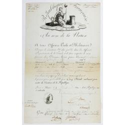
Passeport.
Passport for the United States in the name of Madeleine Lavit Femme Lory, issued by the Commission of Interior Relations and approved by the Committee of Public Safety.Th...
- $750 / ≈ €660
Place & Date: Paris, 1795
![Mappa Mondo tagliato sulpiano di unmeridiano Emisfero Occidentale. [togther with] … Orientale.](/uploads/cache/48543-250x250.jpg)
Mappa Mondo tagliato sulpiano di unmeridiano Emisfero Occidentale. [togther with] … Orientale.
World map on two sheets - Western Hemisphere (North and South America, Oceania, Greenland) and Eastern Hemisphere (Europe, Africa, Asia, Australia). Published by Pazzini,...
- $500 / ≈ €440
Place & Date: Siena, 1796
![Le Isole di Sandwich delineate sulle osservazioni del Cap Cook. [Hawaii]](/uploads/cache/43195-250x250.jpg)
Le Isole di Sandwich delineate sulle osservazioni del Cap Cook. [Hawaii]
FIRST EDITION on laid paper. Cassini’s splendid map depicts Sandwich islands, old name for Hawaii islands, at the end of the eighteenth century. The splendid cartouche ...
Place & Date: Rome, 1798
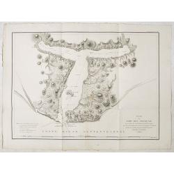
Plan du Port des Francais sur la Cote du Nord-Ouest de l'Amerique, par 58°37' de Latitude Nord et 139°50' de Longitude Occidentale, Decouverte le 2 Juillet 1786, par les Fregates Francaise la Boussole et l'Astrolabe.
Chart of the entrance of Bassin de L'Quest , visited on July 2nd 1786 by La Perouse. On many 18th century maps we find a depiction of Mer de L'Quest or Sea of the West a ...
- $500 / ≈ €440
Place & Date: Paris, 1798

Carte Réduite des Côtes Orientales Del'Amérique Septentrionale Contenant partie du Nouveau Jersey, la Pen-sylvanie, le Mary-land, la Virginie, la Caroline Septentrionale, la Caroline Méridionale et la Georgie. . .
Scarce Rome edition of an French map made expressly for use of the French Navy during the American Revolution. Covering the area of Maryland, North and South Virginia. Ph...
- $900 / ≈ €792
Place & Date: Genova, Yves Gravier, c.1800
![[Lot of 5 maps] Kaart van de noord-west kust van Amerika en de noord-oost kust van Asia.](/uploads/cache/19136-250x250.jpg)
[Lot of 5 maps] Kaart van de noord-west kust van Amerika en de noord-oost kust van Asia.
- Kaart van de noord-west kust van Amerika en de noord-oost kust van Asia. Opgenoomen in de Jaaren 1778 en 1779. Captain James Cook (1728-79), explorer, circumnavigato...
Place & Date: Leiden, 1795-1803

Charte von der mündung des Mississippi. Weimar, Verlage des Landes Indust. Compt. 1803.
Scarce map showing the mouth of the Mississippi into the Gulf of Mexico. With Pensacola in Western Florida, Mobile Bay in Alabama and Louisiana with New Orleans and their...
- $300 / ≈ €264
Place & Date: Weimar, 1803
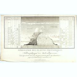
Géographie des Plantes Equinoxiales - Tableau physique des Andes et pays voisins. . .
Physical Portrait of the Andes and adjacent lands", organized around the Chimborazo and Cotopaxi volcanoes in Ecuador.With local vegetation is illustrated pictoriall...
- $1000 / ≈ €880
Place & Date: Paris, 1805
Nouvelle Espagne, Nouveau Méxique, Isles Antilles, par Robert de Vaugondy corrigés par le Cen. Lamarche Géog. Successeur de Vaugondy. l''An 3e.
Although dated 1794/95 [l'An 3e.], the map is a copy of an earlier map which appeared in Robert de Vaugondy's 1778 atlas. Hence, it does not show the newly independent Un...
- $300 / ≈ €264
Place & Date: Paris, 1794 - 1806

Isle de la Jamaïque.
Map of Jamaica, from Atlas de la Géographie de toutes les parties du monde.. Ouvrage destiné pour l'education, et nécessaire aux négocians, aux voyageurs, aux fonctio...
Place & Date: Paris, Prudhomme, Levrault, Debray, 1806
Selling price: $25
Sold in 2016

Homme & Femme Ottawas.
Hand-colored mezzotint of Native Americans engraved by Félix Mixelle and Lachaussée Jeune after Jacques Grasset de Saint-Sauveur.As an etcher, drawer and writer, Grasse...
- $75 / ≈ €66
Place & Date: Paris,1801-1806

L'Amérique Méridionale, Divisée en ses Principaux Etats.
Map of South America, from Atlas de la Géographie de toutes les parties du monde .. Ouvrage destiné pour l'education, et nécessaire aux négocians, aux voyageurs, aux ...
Place & Date: Paris, Prudhomme, Levrault, Debray, 1806

Carte de la Nouvelle Angleterre, Nouvelle York, Nouvelle Jersey, et Pensilvanie.
Map of the north eastern part of the United States, from Atlas de la Géographie de toutes les parties du monde .. Ouvrage destiné pour l'education, et nécessaire aux n...
Place & Date: Paris, Prudhomme, Levrault, Debray, 1806
![A Map of the United States and Canada, New-Scotland, New-Brunswick and New-Foundland ... [together with] A Map of the West-Indies and of the Mexican-Gulph...](/uploads/cache/39235-250x250.jpg)
A Map of the United States and Canada, New-Scotland, New-Brunswick and New-Foundland ... [together with] A Map of the West-Indies and of the Mexican-Gulph...
A Map of the United States and Canada, New-Scotland, New-Brunswick and New-Foundland / Carte des Etats Unis, avec Le Canada, la Nouvelle Ecosse, le Nouveau Brunswick &...
Place & Date: Paris, 1806
Die Vereinigten Staaten von Nord-Amerika.
Nice little German map of the early United States. The only state shown west of the Appalachian Mountains is Kentucky. Above which is a strangely shaped unnamed region (O...
- $250 / ≈ €220
Place & Date: Augsburg, 1812

West indien.
Nice small map of The West Indies, with Cuba, Jamaica, S.Domingo, etc. Southern tip of Florida is included. Map by Johannes Walch in his rare Allgemeiner Atlas Nach den b...
- $150 / ≈ €132
Place & Date: Augsburg, 1812
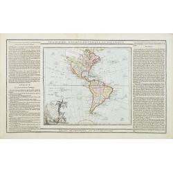
Amérique, réduite d'après celles d'Arrowsmith en 4 flles Par J.N.Champion, Ingénieur-Geographe et . . . Nouvelles découvertes de Clacke et du Major Pike . . .
A charming folding-map of America, drawn by J.N. Champion. The title explains that the map used the latest information by Alexander Humboldt and Clarck and Pike. Dated 18...
- $500 / ≈ €440
Place & Date: Paris, 1815

Carte d' Amérique Septentrionale 1817.
Map of North and Central America. Engraved by E.Collin, active at 23, quai des Augustins, Paris.
- $300 / ≈ €264
Place & Date: Paris, 1817
Little Egg Harbour.
A small sea chart showing Little Egg Harbour east of Tucker's Island. This map was published in the “American Coast Pilot”, a detailed guide to harbors, capes and hea...
- $50 / ≈ €44
Place & Date: New York, 1817
![Etats-Unis de L'Amerique Septentrionale. [Two sheets in manuscript ]](/uploads/cache/03972-250x250.jpg)
Etats-Unis de L'Amerique Septentrionale. [Two sheets in manuscript ]
Two sheets giving an detailed information in French, about population in the year 1810, principal cities, products of industry and commerce, financial situation for the y...
- $2000 / ≈ €1761
Place & Date: France, ca. 1819

Gedeelte van den Vereenigden Staat van Noord Amerika.
A rare an detailed map of the eastern part of the United States of America. After Isaac Weld's map from his Travels through the States of North America 1799. Barbara Back...
- $650 / ≈ €572
Place & Date: Netherlands c. 1820
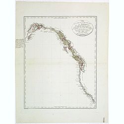
Carte de la partie de la cote nord-ouest de l'Amerique. Reconnue pendant les Etes de 1792, 1793 et 1794 depuis 29054' de latitude nord et 244033' de. . .
Detailed and rare map of the Gulf of Alaska, British Columbia, south to St.Francisco.Prepared by Edward Roberts after information by George Vancouver. Engraved by Tardieu...
Place & Date: Paris, 1820
Selling price: $150
Sold in 2011
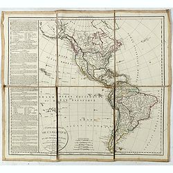
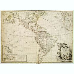
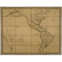
Carte générale de l' Amérique divisée en ses principaux états . . .
Map of North and South America. By C. F. Delamarche, successor of Robert de Vaugondy, Geographer. Descriptive text to the left.
Place & Date: Paris, 1820

Grenada.
A delightfully detailed map the West Indian island Grenada by John Thomson. The map displays excellent detail concerning roads, rivers, towns, bays, harbours and other in...
- $50 / ≈ €44
Place & Date: Edenburgh, 1821

Tobago.
A delightfully detailed map of the West Indian island Tobago by John Thomson. The map displays excellent detail concerning roads, rivers, towns, bays, harbors, and other ...
- $50 / ≈ €44
Place & Date: Edenburgh, 1821
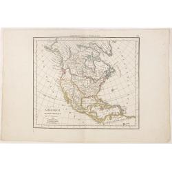
L'America septentrionale.
Charming and finely engraved map of North America from the rare atlas Atlante Tascabile o sia Serie di Num. XXI Cartine Geografiche nelle quali si rappresenta in ristrett...
- $275 / ≈ €242
Place & Date: Rome, 1823
Amérique septentrionale.
A fine map of North America published by the well-known Paris publisher of maps, globes and atlases C.F. Delamarche.
- $110 / ≈ €97
Place & Date: Paris, 1824
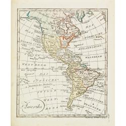
Amerika
Scarce miniature map of the Western Hemisphere.
- $200 / ≈ €176
Place & Date: Augsburg, 1824