Browse Listings in America
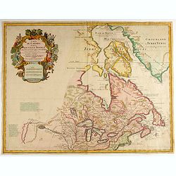
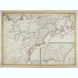
Carte du Canada ou de la Nouvelle France.
Fourth state of the map of Canada published by Delisle with the imprint "sur le Quai de l’Horloge a l’Aigle d’Or avec Privilege pour 20 ans, 1703". Beneat...
Place & Date: Paris, 1703
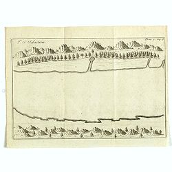
I. S. Sebastien.
Simplified bird's-eye view of Ilha de São Sebastiao, part of an archipelago off the southern coast of Brazil 210 miles from Rio de Janeiro. It was discovered on January ...
- $225 / ≈ €198
Place & Date: Amsterdam, E. Roger, 1703
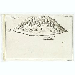
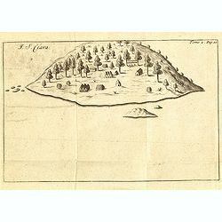
I. S. Clara.
Island "S. Clara" in Brazil just a few degrees north of the Tropic of Capricorn.From volume two of the French reissue of the account of early Dutch voyages. The...
- $150 / ≈ €132
Place & Date: Amsterdam, E. Roger, 1703
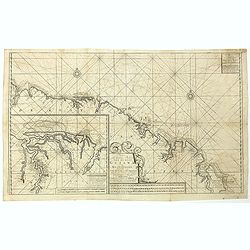
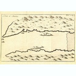
Nieuwe gelyk Graadige Paskaart van de Kust van Guiana in West-Indien.
Detailed chart of Guiana in South America. Two scales are given in both maps: Dutch, French and English nautical miles.The inset chart provide detailed view of the Camopi...
- $650 / ≈ €572
Place & Date: Amsterdam, 1684 - 1704
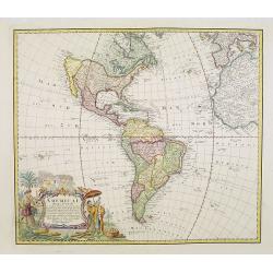
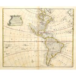
Carte du gouvernement de l'Amerique.
A double page sheet including a fine map of America, with California with indented northern coastline (130x92mm.) and New Mexico extending across most of western North Am...
- $300 / ≈ €264
Place & Date: Amsterdam, 1705
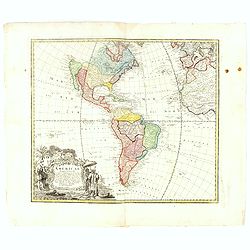
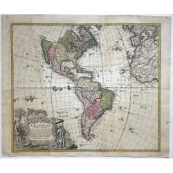
Carte du gouvernement de l'Amerique.
A double page sheet including a fine map of America, with California with indented northern coastline (130x92mm.) and New Mexico extending across most of western North Am...
- $300 / ≈ €264
Place & Date: Amsterdam, 1705

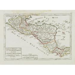
Paraguay o Prov. De Rio De La Plata cum regionibus adiacentibus Tucuman et Sta. Cruz De la Sierra.
An attractive map centered on Paraguay. Title cartouche on the upper right-hand corner, on the ocean a ship and a sea monster are depicted.
- $300 / ≈ €264
Place & Date: Amsterdam, 1708
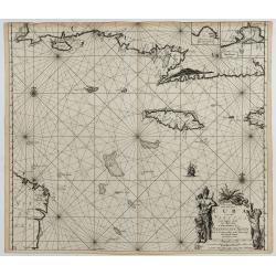
Pas kaart vande Zuyd kust van Cuba en van Geheel Jamaica…
A nautical chart covering the southern part of Cuba, all of Jamaica and the western tip of Hispaniola and a bit of the Honduras coastline. Insets of "Baya Oristan in...
Place & Date: Amsterdam, J. van Keulen, 1697-1709
La Terre du Nord.
Map of the Arctic Circle, set within a series of decorative borders, printed from a different copper plate. All counties that lie within or near to the North Pole are sho...
- $1000 / ≈ €880
Place & Date: Amsterdam, 1713
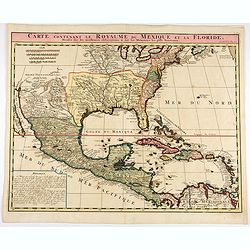
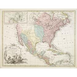
Carte contenant le Royaume du Mexique et la Floride.
This is a derivative of Delisle's landmark map of the southern part of North America.The detailed map shows many English settlements along the East Coast and carefully no...
- $1000 / ≈ €880
Place & Date: Amsterdam, 1719

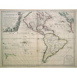
Nouvelle carte de geographie de .. Meridionale de l'Amerique
Chatelain's map of South America. The title is in two lines across the map. The tracks of Magellan, de la Maire, de Mendana, etc. are shown.On each side, borders appear a...
- $250 / ≈ €220
Place & Date: Amsterdam, 1719

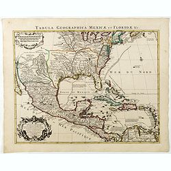
Carte contenant le Royaume du Mexique et la Floride.
This is a derivative of Delisle's landmark map of the southern part of North America. The detailed map shows many English settlements along the East Coast and carefully n...
- $900 / ≈ €792
Place & Date: Amsterdam, 1719
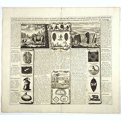
Carte qui contient la manière.. Niagara..
A series of 12 engravings together with descriptive text, derived from the works of Lahontan and Hennepin, illustrating the methods of the Indians hunting buffalo and sim...
Place & Date: The Hague 1720

Carte Particuliere de Isthmus ou Darien qui Comprend le Golfe de Panama &c. Cartagena, et les Isles aux Environs.
Finely executed map of a portion of Central America, extending from the East Coast of Nicaragua and Costa Rica in the northwest to Cartagena and Santa Martha in modern Co...
- $1250 / ≈ €1101
Place & Date: Amsterdam, 1720

Nova tabula geographica complectens borealiorem..
A finely engraved pair of maps designed to be cut and joined together to provide a continuous coastline of North America from the Carolinas to Newfoundland and along the ...
Place & Date: Amsterdam 1720

Particularitez Curieuses de l'Ile de St. Christophle et de la Province de Bemarin . . .
Six meticulously detailed and engraved scenes of the island of St. Kitts, also known as Saint Christopher, and the province of Bemarin, indigenous plants, animals, reptil...
Place & Date: Amsterdam, 1720
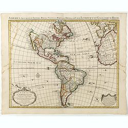
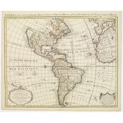
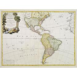
L'Amerique ou le Nouvelle Continent.. Dedieé et presenteé a monseigneur Law.
State one. The map has been prepared by Jean Baptiste Nolin (the elder) has a dedication to Monseigneur LAW controlleur general des finances .Rare general map of the Amer...
- $2200 / ≈ €1937
Place & Date: Paris, 1720

Mappa Aestivarum Insularum, alias Barmudas..
The map is the rare re-issue of the Blaeu's copperplate of 1630. The map includes the arms of Bermuda and England, and lists proprietors of the various tribes into which ...
- $1600 / ≈ €1409
Place & Date: Amsterdam, 1720
Carte du Mexique et de la Floride, des terres angloises et des isles Antilles, du cours et des environs de la rivière Mississipi. . .
A Dutch edition of De L'Isle's map. It was the first printed map to portray accurately the course and mouth of the Mississippi River. Showing the explorations of d'Ibervi...
Place & Date: Amsterdam, 1722
I. S. Clara.
Island "S. Clara" in Brazil just a few degrees north of the Tropic of Capricorn.From volume two of the French reissue of the account of early Dutch voyages. The...
- $100 / ≈ €88
Place & Date: Amsterdam, F. Bernard, 1725
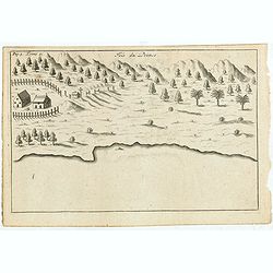
Porto il Desire.
Simplified bird's-eye view of Port Desire or Puerto Deseado in present-day Argentina.From volume two of the French reissue of the account of early Dutch voyages. The Fren...
- $150 / ≈ €132
Place & Date: Amsterdam, F. Bernard, 1725
Isle du Prince.
Simplified bird's-eye view of "Isle du Prince" in present-day Argentina.From volume two of the French reissue of the account of early Dutch voyages. The French ...
- $75 / ≈ €66
Place & Date: Amsterdam, F. Bernard, 1725

Haven van Aquapulco in ' Coninkryk van Nova Spagnien in de Zuyd Zee.
A finely engraved plan of the harbor, fort and village of Acapulco drawn from a hilltop vantage point looking out to sea. Several galleons are pictured approaching or anc...
- $500 / ≈ €440
Place & Date: Amsterdam, 1726
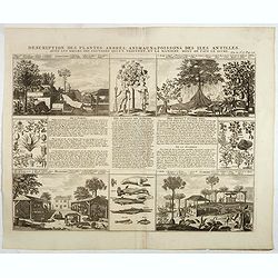
Description des plantes, arbres, animaux & poissons des Antilles . . .
Interesting sheet with eight detailed views illustrating fauna and flora on the Antillean islands, and how the natives are making sugar, with descriptive French text, fro...
- $150 / ≈ €132
Place & Date: Amsterdam, 1728

Nieuwe Wassende Graade Zee Kaart over de Spaanse Zee Vant Kanaal tot 't Eyland Cuba in Westindia. . .
¤ Engraved by I.van Anse. A very representative example of a Dutch chart of the Atlantic, showing the north-east coast of America, the coasts of Africa and Europe and So...
Place & Date: Amsterdam, 1728

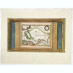
This Draught of the North Pole is to show all the Countries near and adjacent to it . . .
The polar map shows the latest discoveries and routes of numerous explorers during their attempts to find a Northwest and Northeast Passage, including James, Hudson, and ...
- $300 / ≈ €264
Place & Date: London, ca. 1728

Carte qui contient..Iles & Terres..L'Amerique..Jamaique..
Eight maps on one sheet. From Chatelain's Atlas Historique et Méthodique . Including maps of Bermuda, Jamaica, New England with Long Island, Carolina, Chesapeake and Del...
Place & Date: Amsterdam, 1728
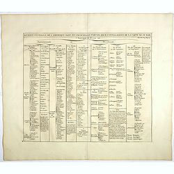
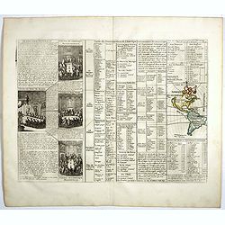
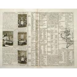
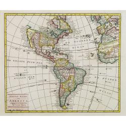
Division generale de l'Amerique dans ses principales parties pour l'intelligence de la carte de ce païs.
This folio sheet gives a breakdown of America into the northern and southern regions. These are further subdivided into the various countries and provinces.Henri Abraham ...
- $25 / ≈ €22
Place & Date: Amsterdam, 1728

Novum Amsterodamum. . .
Three engravings on one page are set in a decorative, separately engraved border. - In the upper left is a good example of one of the earliest available views of New York...
- $1200 / ≈ €1057
Place & Date: Leiden, 1729
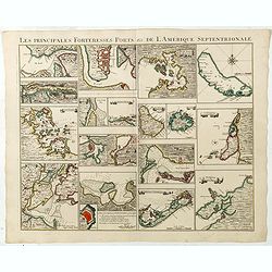
Les Principales Forteresses Ports &c de L'Amérique Septentrionale. . .
This sheet contains 19 small but detailed maps and plans of harbours, towns, forts and islands from the eastern seaboard and the West Indies, all but one plan with title ...
Place & Date: Amsterdam, 1733
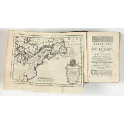
Avantures du Sr. C. Le Beau, avocat en parlement ou Voyage curieux et nouveau parmi les Sauvages de l'Amérique Septentrionale. Dans lequel on trouvera une Description du Canada… Ouvrage enrichi d'une Carte et des figures necessaires.
A description of Huron, Iroquois, and Algonquin customs, written in charming style and based, the Author claims, on observations made on a trip to America in 1729." ...
- $2500 / ≈ €2201
Place & Date: Amsterdam, 1738
America.
A very nice map of the American continent with California as an island and an adorned title cartouche.From Francisco Giustiniani for El Atlas abreviado o el nuevo compend...
- $300 / ≈ €264
Place & Date: Leon de Francia (Lyon), Jaime Certa, 1739

L'Amerique septentrionale, Dressée sur les memoires les plus recens. . .
A very detailed map extending from Hudsons Bay to Panama, and including the West Indies. The map is a later copy of Guillaume de L'Isle's foundation map of North America,...
Place & Date: Amsterdam, 1739
Carte d'Amerique dressée par l'usage du Roy..
Fine map prepared by G.d'Isle depicting North and south America, the west coast taken north to Cap Mendocin and Cap Blanc with a note Entrée decouverte par Martin d'Agui...
Place & Date: Amsterdam, 1739

Carta geografica della america meridionale.
Uncommon map of South America based upon Guillaume De L'Isle's map. Includes the routes of early explorers in the Pacific, including Magellan, Drake, Le Maire, Mendana, V...
- $350 / ≈ €308
Place & Date: Venice, 1740
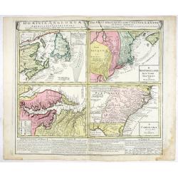
Dominia Anglorum in America Septentrionali.
Four maps on one sheet (New Found land/ New England/ Virginia and Carolina/Florida) based on J.B.Homann's map, showing British possessions in North America. The upper lef...
- $750 / ≈ €660
Place & Date: Nuremberg 1740

Dominia Anglorum in praecipuis Insulis Americae ut sunt Insula S. Christopheri, Antegoa, Iamaica, Barbados nec non Insula Bermudes vel Sommers . . .
Four maps of the islands of West Indies (St. Christoph "Delineatio Insulae St, Christophori alias I. Kitts", Antigua "Insula Antegoa", Barbados &q...
- $500 / ≈ €440
Place & Date: Nuremberg, 1740
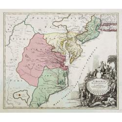
Virginia Marylandia et Carolina..
An attractive and detailed map, covering the coastline from Long Island in the north to just south of Cape Feare in Carolina, with the large fictitious Apalache Lacus in ...
- $2000 / ≈ €1761
Place & Date: Augsburg, 1740

Neu Engeland Neu York, Neu Jersey und Pensilvanien & c. . .
The scarce German edition of Moll's popular and rather significant map which appeared in Oldmixon's 1708 book, Das Britische Reich in America. and then in other editions ...
- $450 / ≈ €396
Place & Date: Lemgo, 1744

L'Amerique Meridionale Dressée sur les Observations . . .
Detailed map of South America prepared by De L'Isle, with fine title cartouche.
- $500 / ≈ €440
Place & Date: Amsterdam, ca. 1745

Carte du Paraguay, du Chili, du Detroit de Magellan &c.
Large handsome map of the southern part of the continent with good interior detail for the period. The route of 18th century explorations are shown along with notations c...
Place & Date: Amsterdam c. 1745
Carte d' Amerique Dressee pour l'Usage Du Roy. . .
Detailed copper-engraved map of the American continent. Decorative title cartouche with foliate garland, and embellished lettering of d' Amerique. The western parts of Af...
- $1000 / ≈ €880
Place & Date: Amsterdam c. 1745

Carte de la Louisiane et du Cours du Mississipi Dressée sur un grand nombre de Memoires..
Covens & Mortier's issue of Delisle's influential map of the French possession of Louisiana. Updated to include New Orleans. When originally published in 1718, it was...
- $2400 / ≈ €2113
Place & Date: Amsterdam, c. 1745

L'Amerique Meridionale Dressée sur les Observations..
Detailed map of South America prepared by De L'Isle, with fine title cartouche.The map is from a Dutch edition of De L'Isle's work entitled, Atlas Nouveau, Contenant Tout...
- $500 / ≈ €440
Place & Date: Amsterdam c. 1745
Americae Mappa generalis.
Johann Baptist Homann's well-engraved second map of America has a large decorative cartouche. Detailed map of the western hemisphere.The interior of North America has new...
- $700 / ≈ €616
Place & Date: Nuremberg, 1746
Americae Mappa generalis Secundum legimitas projectionis Stereiographiae regulas. . . MDCCXXXXVI
Johann Baptist Homann's well-engraved second map of America has a large decorative cartouche. Detailed map of the western hemisphere.The interior of North America has new...
- $600 / ≈ €528
Place & Date: Nuremberg, 1746
A new general map of America drawn from several..
Extremely faint strip of age toning on part of the centerfold, otherwise fine condition. The Pacific Northwest is left open with the note Parts Undiscovered. The coastlin...
- $500 / ≈ €440
Place & Date: London, 1747
Americae Mappa generalis.
Full title and impressum in an extensive cartouche bottom left: 'Americae Mappa generalis Secundum legimitas projectionis Stereiographiae regulas (..) Homannianis Heredib...
- $650 / ≈ €572
Place & Date: Nuremberg, 1748

Amérique Méridionale.
Nice small map of South America. Dated 1748. From Atlas Portatif Universel, by Robert de Vaugondy.Page 105 outside border top right. Mary Sponberg Pedley does not mention...
- $75 / ≈ €66
Place & Date: Paris, later than 1748

Amérique Septentrionale. . .
A fine small map of North America, extending from Hudsons' Bay to Panama, and including the West Indies. Dated 1748.From Atlas Portatif Universel, by Robert de Vaugondy.P...
- $200 / ≈ €176
Place & Date: Paris, later than 1748
Partie du Mexique ou de la Nouvelle Espagne Où se trouve l'Audience de Guatimala.
Nice small map of Central America, extending from the Yucatán Peninsula to Panama. From Atlas Portatif Universel, by Robert de Vaugondy.From Atlas Portatif Universel, by...
Place & Date: Paris, later than 1749

Partie Orientale de la Terre Ferme ou l'on trouve la Guiane.
Nice small map encompassing a large area between the Orinoco and the River Amazon.From Atlas Portatif Universel, by Robert de Vaugondy.Page 107 outside border top right. ...
- $75 / ≈ €66
Place & Date: Paris, later than 1749

Terre de Sainte Croix, nommée à présent Bresil.
Detailed small map showing most part of the Brazilian seacoasts, from the mouth of the Amazon River as far as the island of Sao Sebastiao.From Atlas Portatif Universel, b...
- $75 / ≈ €66
Place & Date: Paris, later than 1749

Amerique méridionale. . .
Detailled map of South America from his "Atlas Universel".Gilles Robert de Vaugondy (1688–1766), also known as Le Sieur or Monsieur Robert, and his son, Didie...
- $150 / ≈ €132
Place & Date: Paris, 1750

Carte de La Riviere de la Plata . . .
Map of La Plata Riviera. Across the top is an extensive list of 22 important sites and locations keyed to the plan with tiny letters and numbers.Jacques Nicolas Bellin (1...
- $350 / ≈ €308
Place & Date: Paris, 1750
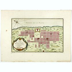
Plan de la ville de Buenos-Ayres.
Early plan of Buenos-Ayres city. Across the top is an extensive list of 22 important sites and locations keyed to the plan with tiny letters and numbers.Jacques Nicolaas ...
- $300 / ≈ €264
Place & Date: Paris, 1750

Nieuwe Wassende Graade Zee Kaart over de Spaanse Zee Vant Kanaal tot 't Eyland Cuba In Westindia.
Rare two-sheet blue-back sea chart of the Atlantic and Eastern part of North America., published by Gerard Van Keulen. The map extends from the latitude of Newfoundland a...
- $2500 / ≈ €2201
Place & Date: Amsterdam, ca. 1728-1751
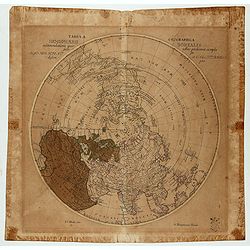
Tabula Geographica Hemisphaerii Borealis…
Polar map with a diameter of 30cm which shows the fictitious Mer de L’Ouest prominently with an extensive river system connecting it with the Great Lakes and thus formi...
- $150 / ≈ €132
Place & Date: Berlin c.1753

Carte de L'Empire du Mexico.
A good engraved map of Mexico, with rococo title cartouche lower left. From l'Histoire générale des voyages .
- $75 / ≈ €66
Place & Date: Paris, 1754
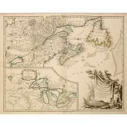
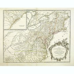
Partie de l'Amerique Septent ...
A fine copy of this map of New Foundland, Nova Scotia and the course of the St.Laurence to Lake Ontario. An inset shows Bellini's famous and important map of the Great La...
- $800 / ≈ €704
Place & Date: Paris, 1755
Carte des Possessions Françoises et Angloises dans le Canada, et partie de la Louisiane.
First state of this separately published map of the European Colonies in the New World east of the Mississippi River. This map was published in 1756 to provide informatio...
Place & Date: Paris, 1756

Suite de Perou Audience de Lima.
Uncommon edition of this accurate map showing the southern Peruvian coast, the ranges and villages of numerous Indian tribes are shown.FromAtlas Portatif pour servir a l'...
- $100 / ≈ €88
Place & Date: Amsterdam, 1756

L'amerique meridionale dressee sur les memoires le plus recens. . .
Rare and decorative map of South America with good detail and interesting notations concerning the explorations of the interior. With in the lower right corner a title ca...
- $550 / ≈ €484
Place & Date: Amsterdam, 1757
L'Amerique septentrionale, Dressée sur les memoires les plus recens. . . MDCCLVII
A rare map of North America, showing good detail, especially in the region between the Appalachians and the Mississippi and the course o the Mississippi to its source, wh...
- $1500 / ≈ €1321
Place & Date: Amsterdam, 1757

America Meridionalis.
This is the more scarce edition with the title cartouche lower left surrounded by Neptune and a native Indian.A rather accurate depiction and descriptions of South Americ...
- $550 / ≈ €484
Place & Date: Augsburg, c. 1760
L'Amerique divisée en ses principaux Etats..
Uncommon map published by Lattré. This map is most notable for its depiction of "Mer de L'Ouest" or "Sea of the West". A great sea, easily the size o...
- $900 / ≈ €792
Place & Date: Paris, 1760

America Meridionalis.
The title cartouche lower left surrounded by native Indians and an Elephant.A rather accurate depiction and descriptions of South America. Brazil is slightly enlarged and...
Place & Date: Augsburg, c. 1760
![[The Americas] AMERIQUE](/uploads/cache/20599-(2)-250x250.jpg)
[The Americas] AMERIQUE
A map depicting both the Americas. With on both sides a descriptionary text. All within an elaborate and very decorative border. Claude Buy de Mornas (d. 1783), géogra...
- $350 / ≈ €308
Place & Date: Paris, 1761

Vue de la Rue du Roi, vers la Porte de la Campagne a Boston.
A vue d'optique of the city of Boston. A view of a typical Bostonian street, with buildings opening directly onto the throughway, groups of people, gentlemen, workers and...
Place & Date: Augsburg, 1762

Carte Hydrographique de la Baye de la Havane.. N° 69.
A well-engraved and highly detailed chart of the walled city of Havana and its harbor features inset plans of three forts (La Punta, El Morro, and La Real Fuerza) as well...
- $2000 / ≈ €1761
Place & Date: Paris, 1762

Carte de la Guyane Françoise et l'Isle de Cayenne..
A well engraved and highly detailed chart of French Guiana and the island of Cayenne. Made in 1763 by Jacques Bellin (1703-72), a prolific cartographer assigned the Minis...
- $500 / ≈ €440
Place & Date: Paris, 1763
Nieuwe kaart van America.
An attractive map of both the Americas, by one of the leading mapmakers in 18th century Amsterdam. Isaak Tirion (d. 1769) was a Amsterdam publisher. His "Nieuwe en b...
- $400 / ≈ €352
Place & Date: Amsterdam, 1765
Partie De L'Amerique Septentrionale... Le Cours De L'Ohio, La N.lle Angleterre, a Nlle York, le New Jersey , La Pensyvanie, Le Maryland, Le Virginie, La Carolina...1755
From the Atlas Universel , a detailed map extending the length of the east coast from Penobscot Bay to Cape Fear and, in an inset, from Cape Fear to Fort St.Georges.This ...
- $800 / ≈ €704
Place & Date: Paris, 1768
![[Lot of 2 maps] Kaart van de onderkoningschappen van Mexico en Nieuw Granada/ Carte de l'Isle de la Martinique, / antique map of the main Carabean islands] Cuba Insula, inset: Havanna portus; Hispanolia Insula.](/uploads/cache/19646-(1)-250x250.jpg)
[Lot of 2 maps] Kaart van de onderkoningschappen van Mexico en Nieuw Granada/ Carte de l'Isle de la Martinique, / antique map of the main Carabean islands] Cuba Insula, inset: Havanna portus; Hispanolia Insula.
Kaart van de onderkoningschappen van Mexico en Nieuw Granada in de Spaansche West-Indien. Carte de l'Isle de la Martinique, 1838 Together 2 maps .- Kaart van de onderk...
Place & Date: Amsterdam, ca 1770

America Septentrionalis, Concinnata juxta Observationes..
This exemplar represents Lotter's version of Delisle's foundation map of North America, published in 1700. The Great Lakes show the French strong holds at Quebec, Montrea...
- $875 / ≈ €770
Place & Date: Augsburg, ca. 1770

Carte des parties Nord et est de l'Asie.. (5 maps on one sheet)
Five maps on one sheet, showing California, Alaska and Syberia, Korea and Japan. South to Korea the island "Quelpaerts".The map is from Diderot's "Encyclop...
- $200 / ≈ €176
Place & Date: Paris, 1772
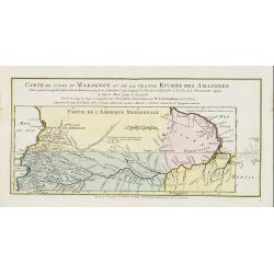
Carte du Cours du Maragnon ou .. Amazones..
Uncommon edition of this map of the river Amazon. In lower right engraved "30."From Atlas Portatif pour servir a l'intelligence de l'Histoire Philosophique et P...
- $75 / ≈ €66
Place & Date: Amsterdam, 1773

Carte de la Nouvelle Angleterre, Nouvelle York et Pensilvanie / Pour servir à l'Histoire Générale des Voyages.
Uncommon edition of this accurate map the east coast from Delaware River till Main.Left hand corner Lake Ontario. In lower right engraved "38."From Atlas Portat...
- $275 / ≈ €242
Place & Date: Amsterdam, 1773

Carte du Mexique.
Uncommon edition of this fine map of Mexico. In lower right engraved 24.From Atlas Portatif pour servir a l'intelligence de l'Histoire Philosophique et Politique des etab...
- $75 / ≈ €66
Place & Date: Amsterdam, 1773
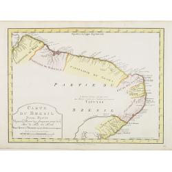
Carte du Bresil Prem. Partie..
Uncommon edition of this accurate map of eastern part of Brazil. In lower right engraved 29a.From Atlas Portatif pour servir a l''''intelligence de l''''Histoire Philosop...
Place & Date: Amsterdam, 1773