Browse Listings in Africa

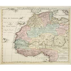
De Cust van Barbaryen van out Mamora tot Capo Blanco..
Six charts on one sheet. The two upper charts covering an area from Cape Blanc to Casablanca. In lower part four insets with detailed charts of islands as Madera, Porto S...
Place & Date: Amsterdam, 1666
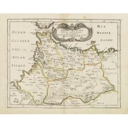
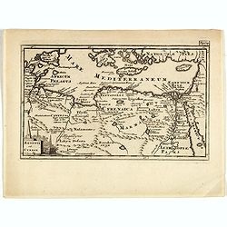
Royaume de Fez. . .
Map of Morocco prepared by N.Sanson and published by Pierre Mariette.Published in an early edition of the small Sanson atlas L'Europe Dediée a Monseigneur . . . Le Telli...
- $120 / ≈ €106
Place & Date: Paris, P. Mariette, 1667

Partie de la Barbarie ou est le royaume d'Alger. . .
Coastal map of North Africa prepared by N.Sanson and published by Pierre Mariette.Published in an early edition of the small Sanson atlas L'Europe Dediée a Monseigneur ....
- $80 / ≈ €70
Place & Date: Paris, P. Mariette, 1667

Partie de la Barbarie ou sont les royaumes de Tunis et Tripoli. . .
Coastal map of Tunisia and Libya prepared by N.Sanson and published by Pierre Mariette.Published in an early edition of the small Sanson atlas L'Europe Dediée a Monseign...
- $750 / ≈ €660
Place & Date: Paris, P. Mariette, 1667

Royaume et desert de Barca, et Aegypte divisee. . .
Map of Egypt prepared by N.Sanson and published by Pierre Mariette.Published in an early edition of the small Sanson atlas L'Europe Dediée a Monseigneur . . . Le Tellier...
- $100 / ≈ €88
Place & Date: Paris, P. Mariette, 1667

Le Royaume de Fez.
Rare map of Morocco published by Jollain in 1667. Published in "Trésor Des Cartes Geographiques Des Principaux Estats de Lunivers".This atlas is based upon Boi...
- $150 / ≈ €132
Place & Date: Paris, 1667

Le Royaume de Marroc.
Rare map of Morocco published by Jollain in 1667. Published in "Trésor Des Cartes Geographiques Des Principaux Estats de Lunivers".This atlas is based upon Boi...
- $100 / ≈ €88
Place & Date: Paris, 1667

Nouvelle description d'Afrique.
Rare map of Africa published by Jollain in 1667. Published in "Trésor Des Cartes Geographiques Des Principaux Estats de Lunivers".This atlas is based upon Bois...
- $250 / ≈ €220
Place & Date: Paris, 1667
Barbarie.
Rare map of the Barbary Coast of Africa published by Jollain in 1667. Published in "Trésor Des Cartes Geographiques Des Principaux Estats de Lunivers".This atl...
- $100 / ≈ €88
Place & Date: Paris, 1667
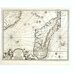
Isle D'Auphine, communement Nommée pae les Europeens Madagascar. . .
One of the most UpToDate maps of Madagascar, also showing the Comoros Islands in the North West and the Reunion Island in the South East.With decorative title cartouche r...
- $900 / ≈ €792
Place & Date: Paris, 1667
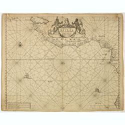
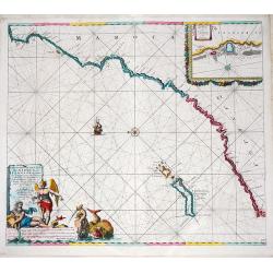
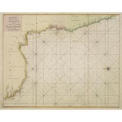
Paskaart van Guinea van C.Verde tot R. deGalion.
Rare edition of Doncker's sea chart of Guinea coast. From an atlas printed in 1668, "l'Atlas de MER ou MONDE AQUATIQUE, Remontrant toutes lescôtes de la Mer…"...
- $1000 / ≈ €880
Place & Date: Amsterdam, 1660-1668

Pascaart van de zee-custenvan Angola, en Cimbedas van Rivier de Galion tot C. de Bona Esperanca.
Rare Doncker's sea chart of the West Coast of Africa, from Angola to the Cape of Good Hope, with a larger inset map of the area from St. Martin's Bay to the Cape of Good ...
Place & Date: Amsterdam, 1660-1668

Cimbebas et Caffariae Littora a Catenbela ad Promontorium. . .
The coast of Angola, South-West Africa and South Africa up to Port Elizabeth. Classic sea chart of Dutch school with excellent baroque embellishment. North oriented to th...
- $750 / ≈ €660
Place & Date: Amsterdam, 1675

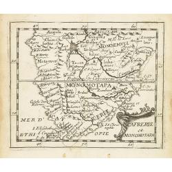
Cafrerie et Monomotapa.
Uncommon miniature map of South Africa, from Pierre Duval's "La Geographie Universeille" dated 1676. Following his Cartes de geographie in 1657, Pierre Duval pu...
- $200 / ≈ €176
Place & Date: Paris, 1676
Cafrerie et Monomotapa.
Uncommon miniature map of South Africa from Pierre Duval's "La Geographie Universeille" dated 1676. Following his Cartes de géographie in 1657, Pierre Duval pu...
- $150 / ≈ €132
Place & Date: Paris, 1676

Cafrerie et Monomotapa.
Uncommon miniature map of South Africa from Pierre Duval's "La Geographie Universeille" dated 1676. Following his Cartes de geographie in 1657, Pierre Duval pub...
- $175 / ≈ €154
Place & Date: Paris, 1676

Azaamurum.
A very nice view of the town of Azemmour in Morocco. With a verse in two languages underneath the picture.The poet and topographer from Comothau, Daniel Meisner (1585-162...
- $80 / ≈ €70
Place & Date: Frankfurt, 1623-1678
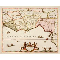
Guinea.
A close copy of the map by Blaeu. Covers the Guinea and Benin coast. A very decorative map with a large title cartouche. At bottom right two putti area carrying an elepha...
- $1000 / ≈ €880
Place & Date: Amsterdam, 1680
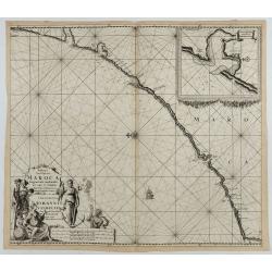
Paskaart van de kust van Maroca beginnende van Larache tot aan C. Cantin. . .
A nautical sea chart of the coast of Morocco. Insert at top right: 'Nieuwe Afbeelding van de Rivier Rio Rebata in 't Groot".Bottom right: chart number '32'. Compass ...
Place & Date: Amsterdam, ca.1682
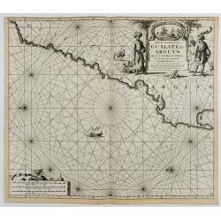
Paskaart van de Kuste van, Gualate en Arguyn. Beginnende van C. Bajador tot C. Blanco. . .
A nautical showing the northwestern coast of Africa, along Western Sahara from Cape Bojador to Cape Blanc. Ornate title cartouche in top right corner shows two main figur...
Place & Date: Amsterdam, ca.1682
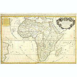
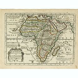
L'Afrique divisée suivant l'estendue de ses principales parties ou sont distingués les vns des autres . . .
A second state of this fine mile-stone map of Africa with a decorative title and scale cartouche. As the title indicates, this map is based on the geography of Guillaume ...
- $750 / ≈ €660
Place & Date: Paris, 1685
Nieuwe Pascaert van de Kust van Maroca en Zanhaga. . .
A very fine sea chart of the west coast of Morocco between C.Cantin tot C.Bajador and the Canary Islands, Lanzerote and Fuerteventura. With a very large decorative title-...
Place & Date: Amsterdam, ca 1685

Alexandrie Ville d'Egipte sur la mer Méditeranée..
A very RARE panoramic view of the city of Alexandria, including a legend in the lower part. The plate is numbered in brown pencil in the upper right corner.Engraved by Pi...
- $100 / ≈ €88
Place & Date: Paris, c. 1690
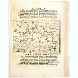
Isola della Guinea. / Isola Gore.
Fine map of Guinea, from Isolario Dell'Atlante Vento.On verso a map of the island Goeree (130x172mm). The sheet dimension is 485x350mm
- $300 / ≈ €264
Place & Date: Venice, 1690

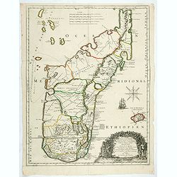
Isola di Madagascar o di S. Lorenzo Scoperta dà Portoghesi nell anno 1506. . .
A beautiful and flamboyantly engraved large-scale map of Madagascar, Bourbon and part of the coast of Mozambique. On verso a smaller map Madagascar (170x123mm) The map is...
- $650 / ≈ €572
Place & Date: Venice, ca. 1696

Bocche del Fiume Negro et Isole di Capo Verde. . .
This is a splendid map of the northwestern coast of Africa and the Cape Verde Islands.The map provides details of the various Portuguese discoveries in the region in the ...
- $600 / ≈ €528
Place & Date: Venice, 1696
Mauritana et Africa Proria nunc Barbaria.
A pleasantly engraved map of the north-western part of Africa with the Canary Islands by Phillip Clüver after Strabo. With one cartouche.Phillip Cluver was a German geog...
- $50 / ≈ €44
Place & Date: Leiden, 1697
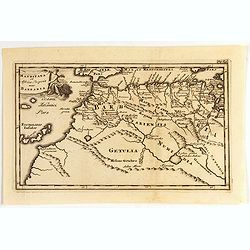
Aegyptus Et Cyrene.
A fine coastal region of Libya, also known as Pentapolis in antiquity. From "Introductio in Universam Geographicam" and edited by Johann Friedrich Heckel Philli...
- $50 / ≈ €44
Place & Date: London, 1697

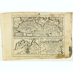
BARBARIE.
An uncommon and delightful map of Northern Africa extends from today's territory of Morocco as far as the Red Sea.With Inset maps of the Nile Delta and the Gulf of Tunis.
- $100 / ≈ €88
Place & Date: Amsterdam, 1700
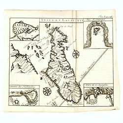
Insula S. Laurentii.
Miniature map of Madagascar, with four inset maps. From the French reissue of the account of early Dutch voyages first published in 1608 by Commelin. The French translati...
- $150 / ≈ €132
Place & Date: Amsterdam, E. Roger, 1702

'T Koninkryk van Marocco, verdeelt in Zeven Landschappen, enz. . .
A Dutch edition of this finely engraved map of Morocco filled with mountain ranges, oases and cities. The map is adorned with a decorative cartouche.
- $90 / ≈ €79
Place & Date: Amsterdam, ca. 1705
L' Afrique Dressee suivant les Auteurs les plus nouvea. . .
Charming map of the African continent with some interesting cartography and filled with notations.The Nile is correctly shown with its origins in Abyssinia. A large Lac d...
- $300 / ≈ €264
Place & Date: Paris, 1719
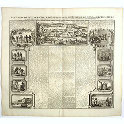
Vue et description de la Ville de Lovango dans le Royaume du Congo. . .
On top a large view of the fabled city of Lovango, text surrounded by ten vignettes of the people and ceremonies of the Kingdom of Congo.Zacharie Chatelain (d.1723) was t...
Place & Date: Amsterdam, 1720

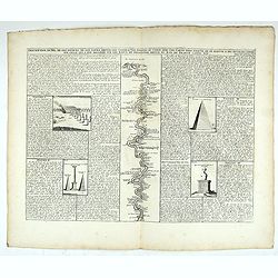
Description des piramides d'Egypte tant au départ qu'au dehors . . .
Engraved text page with 5 views of the pyramids and an image of the Sphinx. From Chatelain's monumental 7 volume "Atlas Historique".Henri Abraham Chatelain (168...
- $36 / ≈ €32
Place & Date: Amsterdam, 1720
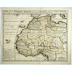
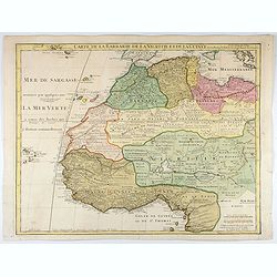
Carte de la barbarie, Nigritie et de la Guinée avec les pays voisins . . .
This great map of western Africa is based on Guillaume Delisle's map. It covers from the Barbary coast to below the equator. There is a mass of geographic detail and nota...
- $300 / ≈ €264
Place & Date: Amsterdam, 1720

Costes de L'Afrique .. ..Cap de Bone Esperance..
In the upper right-hand corner inset map of Saldanha Bay. Numerous place names, soundings and sand banks are shown round the island and the regions are defined by origina...
- $500 / ≈ €440
Place & Date: Amsterdam, 1720
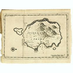
Insulae S. Thomae.
Uncommon map of the Island of St. Thomas located in the Atlantic Ocean near West Africa. From the French reissue of the account of early Dutch voyages first published in ...
- $75 / ≈ €66
Place & Date: Amsterdam, F. Bernard, 1725
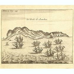
La rade d'Annobon.
Fine print of the arrival of the Dutch fleet by Cornelis Matelief de Jonge at Annobon, September 7th 1605. Cornelis Matelief de Jonge made a trip for the V.O.C. to the Ea...
- $100 / ≈ €88
Place & Date: Amsterdam, J.F. Bernard, 1725
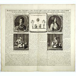
Habillemens Des Arabes & Des Juifs qui sont au Caire avec une partie de leurs divertissements & quelques restes de L'Ancien Idolatrie des peuples D'Egipte.
Decorative set of images the costumes of the Arab and Jewish inhabitants of Cairo, with French text, from Chatelain's monumental 7 volume Atlas Historique. Henri Abraham ...
Place & Date: Amsterdam, 1728
Description du Nil, de ses sources, de son cours depuis les cataractes jusques le Caire . . .
Detailed map of the course of the Nile, from the cataracts of the Nile at the south (top of the image) to Caïro and Giza. At the right, one of the Pyramids is shown (140...
Place & Date: Amsterdam, 1728

Ile de S. Laurens, ou Madagascar, située dans L'Ocean Ethiopien, sur les Côtes de L'Afrique.
Detailed map of Madagascar and Réunion. Published by Pieter van der Aa in "Galérie agréable du monde", completed in 1729. The Galerie was a sixty-six volume ...
- $450 / ≈ €396
Place & Date: Leiden, 1729
Ile de S. Laurens, ou Madagascar, située dans L'Ocean Ethiopien, sur les Côtes de L'Afrique.
Detailed map of Madagascar and Réunion. Published by Pieter van der Aa in "Galérie agréable du monde", completed in 1729. The Galerie was a sixty-six volume ...
- $450 / ≈ €396
Place & Date: Leiden, 1729

Carte du Congo et du Pays des Cafres. . .
Detailed copper-engraved map of southern Africa providing numerous particulars and comments concerning European trade, native kingdoms, and mineral wealth. Includes Madag...
Place & Date: Amsterdam, c. 1730

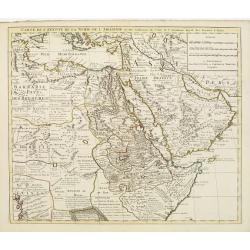
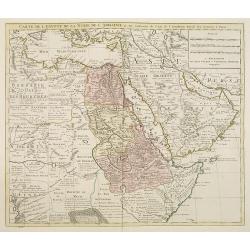
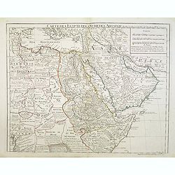
Carte de L'Egypte de la Nubie de L'Abissinie..
Prepared by G.de l'Isle. Uncommon issue by Hendrik de Leth. Very detailed map of northeastern Africa, the Red Sea and the Arabian peninsula shows the political divisions ...
- $500 / ≈ €440
Place & Date: Amsterdam 1740
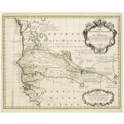
Carte de l'Afrique Françoise ou du Senegal. . .
Large map of the African West coast covering present-day Senegal and Gambia. It provides extensive detail along the Senegal River. The outline hand coloring shows the ext...
- $300 / ≈ €264
Place & Date: Amsterdam, c. 1745
Carte de l'Egypte de la Nubie de L'Abissinie &c..
Detailed copper-engraved map of North-East Africa showing Guinea in the southwest through Ethiopia , the Red Sea to the Persian Gulf.In the northwest, Tunis through Egypt...
- $500 / ≈ €440
Place & Date: Amsterdam, c. 1745
Carte de la Barbarie de la Nigritie et de la Guinée..
Richly engraved map of North and West Africa, based upon the earlier maps of De L'Isle. Richly annotated throughout and with excellent regional detail. It includes the Ca...
- $350 / ≈ €308
Place & Date: Amsterdam c. 1745
Carte de l'Egypte de la Nubie de l'Abissinie. . .
Detailed copper-engraved map of North-East Africa showing Guinea in the southwest through Ethiopia , the Red Sea to the Persian Gulf.In the northwest, Tunis through Egypt...
- $250 / ≈ €220
Place & Date: Amsterdam, 1745
A chart of the coast of Africa from Cape Virde to Cape Bona Esperansa.
Rare and attractive chart of the western part of Africa.
- $800 / ≈ €704
Place & Date: London, 1748
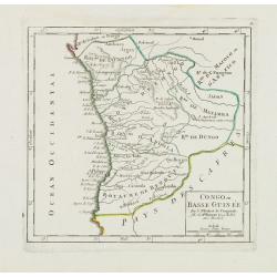
Congo ou Basse Guinée.
Nice small map showing a long stretch of the central Africa west coast and its hinterland. Centered on Luanda.From Atlas Portatif Universel, by Robert de Vaugondy. "...
- $75 / ≈ €66
Place & Date: Paris, later than 1748
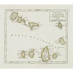
Les Isles du Cap-Verd. . .
Charming small map of the archipelago of Cape Verde. From Atlas Portatif Universel, by Robert de Vaugondy.From Atlas Portatif Universel, by Robert de Vaugondy.Page 87 out...
Place & Date: Paris, later than 1748
Selling price: $120
Sold in 2011

Le Pays des Hottentots aux environs du Cap de Bonne Espérance. . .
A good engraved map of Cape of Good Hope. The geographical features are typical with somewhat exaggerated bays, inlets and prominent mountain ranges. The west coast of th...
- $200 / ≈ €176
Place & Date: Paris, 1748
Partie Orientale de la Haute Guinée.
Nice small map centered on the Gulf of Guinea. Showing Sao Tomé and Principe. From Atlas Portatif Universel, by Robert de Vaugondy. "80" outside border top rig...
- $75 / ≈ €66
Place & Date: Paris, later than 1749

Le Pays des Hottentots . . .
Map of Good Hope Cape. Across the top is an extensive list of 22 important sites and locations keyed to the plan with tiny letters and numbers.Jacques Nicolas Bellin (170...
- $200 / ≈ €176
Place & Date: Paris, 1750

Isle de Magagascar . . .
Map of the island of Madagascar. Prepared by Jacques Nicolaas Bellin (1703-1772) who was one of the most important and proficient French cartographers of the mid-eighteen...
- $75 / ≈ €66
Place & Date: Paris, 1750
![[2 sheets] Carte particuliere de la Cote Occidentale de l'Afrique...](/uploads/cache/42917-250x250.jpg)
[2 sheets] Carte particuliere de la Cote Occidentale de l'Afrique...
A large 2 sheet map of a part of the west coast of Africa that covers The Gambia and Senegal. (When joined the map would measure approx. 1010 x 1400 mm) D'anville's maps ...
- $400 / ≈ €352
Place & Date: Paris, ca. 1751
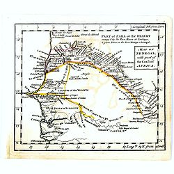
Map of Senegal with part of the coast of Africa.
Uncommon miniature map of Senegal with part of the coast of Africa, engraved by Thomas Kitching for "A New General and Universal Atlas Containing Forty five Maps by ...
- $40 / ≈ €35
Place & Date: London, 1761-1763
![[69] Barbarie.](/uploads/cache/12841-250x250.jpg)
[69] Barbarie.
Charming chart of the harbour of the province of Barbarie in Syria. Showing town and harbour plan, with soundings, anchorages, rocks, shoals, fortifications and lighthous...
- $75 / ≈ €66
Place & Date: Marseille 1764
![[71] Barbarie.](/uploads/cache/12843-250x250.jpg)
[71] Barbarie.
Charming chart of the harbour of the province of Barbarie in Syria. Showing town and harbour plan, with soundings, anchorages, rocks, shoals, fortifications and lighthous...
- $50 / ≈ €44
Place & Date: Marseille 1764

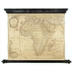
L'Afrique divisée en ses principaux etats par le Sr. Janvier Geographe.
A neatly engraved example of Jean Janvier's 1762 map of Africa. Covers the entire continent as well as the Island of Madagascar and adjacent parts of Persia and Arabia. D...
- $200 / ≈ €176
Place & Date: Paris, ca. 1765

Charta exhibens Situm antiquum Carthaginis, Uticae. . . / A Bird's View of the Situation of Antient Carthage.
A pair of engravings of ancient Carthage in North Africa, from Charles Rollins' "The Ancient History of the Egyptians, Carthaginians, Assyrians, Babylonians, medes &...
- $50 / ≈ €44
Place & Date: London, ca 1768
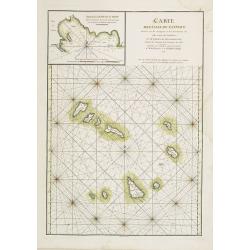
Carte des Iles du Cap-Verd Dressée sur les remarques et les observations les plus exactes des Navigateurs.
French sea chart of the Cap Verde Islands, situated 570 kilometers off the coast of Western Africa.Latitude and longitude scales, compass rose and system of rhumb lines, ...
- $100 / ≈ €88
Place & Date: Paris, Brest, chez Demonville, 1775

Côte de l'Isle de Madagascar depuis la Baye de Vohemare jusqu'à la pointe de l'Est. Plan du Port et de la Baye du Cap de l'Est.
French chart of the east coast of Madagascar.Latitude and longitude scales, compass rose and system of rhumb lines, soundings near coast and in bay areas.D' Après de Man...
- $100 / ≈ €88
Place & Date: Paris, Brest, chez Demonville, 1775

Carte réduite de l'Archipel du Nord-Est de l'Ile Madagascar.
French sea chart of an archipelago off the coast of Madagascar. The northeastern coast of Madagascar is included.Latitude and longitude scales, compass rose and system of...
- $100 / ≈ €88
Place & Date: Paris, Brest, chez Demonville, 1775

Plan des Isles Querimbo, Oybo, et Matemo / Plan de l'Ile de Patte et de son Port.
French sea chart of Isles Patte, Querimbo, Oybo, Matemo on East coast of Madagascar. Latitude and longitude scales, compass rose and system of rhumb lines, soundings near...
- $75 / ≈ €66
Place & Date: Paris, Brest, chez Demonville, 1775

Carte Orientale de Madacascar Depuis la Rivière Ivondrou jusqu'à Mananzari.
Large sea sea chart of the southeast coastline of Madagascar and four inset maps of the harbors and anchorage of Tamatave, Foulpointe, Teintingue und Veninguebe. Inset ma...
- $125 / ≈ €110
Place & Date: Paris, Brest, chez Demonville, 1775
Carte de l'Egypte de la Nubie de l'Abissinie..
Map of east Africa showing South Arabia.
- $200 / ≈ €176
Place & Date: Paris, 1780
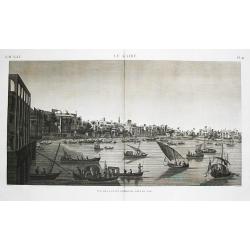
Le Kaire (Cairo). Vue de la place Ezbekyeh, côté du sud
A very fine view of Cairo.
- $500 / ≈ €440
Place & Date: Paris, ca 1780

Vue perpective de l'Isle de St.Helene appartenant a la Compagnie Angloise pour les Indes Orientales.
Decorative optical view of St. Helena. The island is well-known as after the Royal Navy captured Napoleon Bonaparte, he was held hostage on the island until he died in 18...
- $300 / ≈ €264
Place & Date: Paris, 1780

Vue du Bourg de St Denis dans l'Isle Bourbon. (together wit) Vue du Bourg de St.Paul dans l'Ile de Bourbon.
Two views from L'île de la Réunion on one plate. The upper part showing the town and harbour of St. Denis. From "Lettres Édifiantes et Curieuses. . Missionaires d...
- $45 / ≈ €40
Place & Date: Lyon, J. Vernarel and Et. Cabin et C., 1780/1781
Carte de La Barbarie de La Nigritie et de la Guinée.
A detailed engraved map of north west Africa including the Canary and Cape Verde Islands. Engraved by Inselin. Address and date changed, now with the imprint "A Pari...
Place & Date: Paris, 1781
Carte D'Afrique Dressée pour l'usage du Roy. Par Guillaume Delisle, Premier Géographe de Sa Majesté, de l'Académie Royale des Sciences…
Curious late issue of De L'Isle's map of the African continent from 1722 map "Corrigée et Augmentée en 1781". - The decorative map shows the continent Africa ...
- $1250 / ≈ €1101
Place & Date: Paris, 1781

L'Egypte Ancienne et Moderne..
Rare map of Egypt, prepared after J.B.Nolin and published by Monhare for his Atlas Général a l'usage des colleges et maisons d'education.. Louis Joseph Mondhare publish...
- $300 / ≈ €264
Place & Date: Paris, 1783

Carte de l'Egypte Ancienne et Moderne..
Attractive map showing part of the course of the river Nile. Boundaries are outlined in hand color.Ornated with a decorative title cartouche representing a crocodile flan...
- $150 / ≈ €132
Place & Date: Paris, ca 1783

L'Egypte. . .
Scarce map of Egypt, prepared by Nolin and published by L.J. Mondhare for his Atlas Général a l'usage des colleges et maisons d'education.. Louis Joseph Mondhare was ac...
- $75 / ≈ €66
Place & Date: Paris, 1783

Partie septentrionale de l'Afrique contenant l'Egipte. . .
Scarce map of northern part of Africa, prepared by Nolin and published by L.J. Mondhare for his Atlas Général a l'usage des colleges et maisons d'education.. Louis Jose...
- $150 / ≈ €132
Place & Date: Paris, 1783

Partie meridionale de l'Afrique ou se trouvent le Congo. . .
Scarce map of south of Africa with Madagascar, prepared by Nolin and published by L.J. Mondhare for his Atlas Général a l'usage des colleges et maisons d'education.. Lo...
- $200 / ≈ €176
Place & Date: Paris, 1783

L'Afrique divisée en ses principaux Etats assujettie..
Excellent copper engraved map of the continent showing the extent of knowledge in the mid-18th century.While mostly accurate, it does have remnants of fantasy such as the...
- $400 / ≈ €352
Place & Date: Venice, 1776 - 1784
![[Map of Madagascar, Mauricius island and Réunion island, in Cyrillic ].](/uploads/cache/42567-250x250.jpg)
[Map of Madagascar, Mauricius island and Réunion island, in Cyrillic ].
A map of the south eastern coast of Africa and the island of Madagascar, comprehending 2 insets of the island of Bourbon (today Reunion) and Mauritius.The title appears i...
- $750 / ≈ €660
Place & Date: Paris / St.Petersburg, ca. 1790

L'Africa divisa nelle sue principali parti…
Rare map of Africa. Published by Pazzini, Carli (1707-1769) and prepared by Bartolomeo Borghi (1750-1821). Features decorative title cartouche. Included in "Atlante ...
- $300 / ≈ €264
Place & Date: Siena, 1796