Browse Listings in Africa
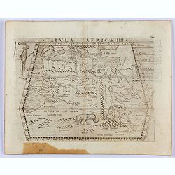
![Tabula IIII Aphricae. [with Prester John]](/uploads/cache/42945-250x250.jpg)
Tabula IIII Aphricae. [with Prester John]
Early Ptolemaic woodcut map of the regions of Africa that were known to the ancients. The twin lake sources of the Nile are located near the Mons Lune (Mountains of the M...
- $950 / ≈ €836
Place & Date: Vienna, 1522- 1535

.Aphricae Tabula secunda continet.
An important early map of the northern coast of Africa and including parts of the islands of Sicily and Sardine.
Place & Date: Vienne, 1541
Tabula Africae IIII.
Gastaldi's map of the Northern Africa, based on Ptolemy. Showing all of the Mediterranean, Ethiopian Interior, the Red Sea, Egypt, the source of the Nile, Red Sea, Dead S...
- $400 / ≈ €352
Place & Date: Venice, 1548

Africa nuova tavola.
Uncommon first edition of this early map of South Africa. Madagascar is called Isola de S. Lorenzo and is oddly shaped.The origin of the Nile conforms to the Ptolemaic co...
- $550 / ≈ €484
Place & Date: Venice, Vincenzo Valgrisi, 1561

Egitto nuova tavola.
Fine early map of Egypt and the Nile delta. Extends east to the Upper Red Sea and West to "Deserto De Marmarica". Nice detail in the lower Nile regions. Page ta...
- $200 / ≈ €176
Place & Date: Venice, 1561

Femina indica Orientalis - Indus Africanus - Singava vulgo dicta sive erratica femina Ori.
Beautiful engraving by Abraham de Bruyn showing inhabitants of Asian and African people with captions in Latin, French and German.Abraham de Bruyn, a Flemish engraver and...
Place & Date: Cologne, c.1577
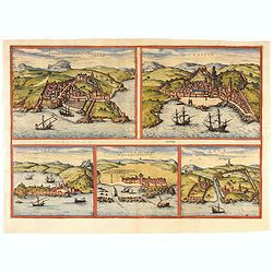
Tingis, Lusitanis, Tangiara. / Tzaffin. / Septa. / Arzilla/ Sala.
Views of the five northern and western African coastal town-view on one sheet: Latin text.From the greatest publication in this genre!. The Civitates was compiled and wri...
- $600 / ≈ €528
Place & Date: Cologne, 1580

Tingis, Lusitanis, Tangiara. / Tzaffin. / Septa. / Arzilla/ Sala.
Views of the five northern and western African coastal town-view on one sheet: Latin text.From the greatest publication in this genre!. The Civitates was compiled and wri...
- $600 / ≈ €528
Place & Date: Cologne, 1580

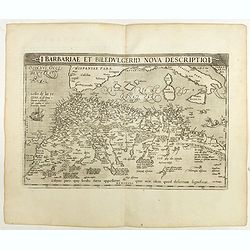
Barbariae et Biledulgerid, nova descriptio.
North-West Africa. Koeman speculated: In view of the important trading relationship between Antwerp and Africa, it is not impossible that the original was a manuscript ma...
- $300 / ≈ €264
Place & Date: Antwerp, 1587
Natoliae.. Aegypti recentior.. Carthaginis ( 3 maps on 1 sheet)
Three maps on one sheet. Map to the left east to the top. Detailed map Turkey, including Cyprus and Crete. Also map of the Nile delta and another map of Tunis. From "...
- $750 / ≈ €660
Place & Date: Antwerp, 1587

Africa ex magnae Orbis Terrae Descriptione.
Very rare separately published "Lafreri" map of Africa. The title in typical Italian scrollwork surmounted by two Cupids in the lower Atlantic. A dedication to ...
- $6000 / ≈ €5283
Place & Date: Venice, ca. 1590
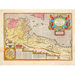
AFRICAE PROPRIAE TABULA In qua, Punica regna vides; Tyrios, et Agenoris / urbem.
AFRICAE PROPRIAE TABULA In qua, Punica regna vides; Tyrios, et Agenoris / urbem. Antique map of North Africa with Carthage. A very decorative map of North Africa wi...
- $350 / ≈ €308
Place & Date: Antwerp, 1590
![Plants found in the island of S. Laurenti [Madagascar].](/uploads/cache/41368-250x250.jpg)
Plants found in the island of S. Laurenti [Madagascar].
‘ A’ denotes a tree with only a few twigs on the top. From this tree, canoes and boats are made. ‘B’ is a bush that the Dutch frequently encountered and was calle...
- $80 / ≈ €70
Place & Date: Frankfurt, 1598
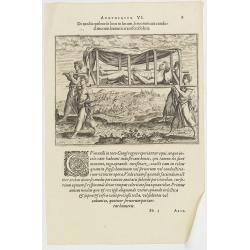
Argumentum VI. De modis quibus de loco in locum, feruorum aut conductitiorum humeris transferri Folent. (How the Congolese are transported)
How the Congolese are transported. None of the horses (probably zebras) are tame enough to ride and the people seem incapable of training the oxen to pull wagons for the ...
- $100 / ≈ €88
Place & Date: Frankfurt, 1598
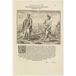
Argumentum IV. Habitus tam magnatum quam plebeiorum descriptus lib. 2 cap. 7. (How the Congolese men dress)
This shows what the inhabitants of the Congo wore before the Portuguese arrived. The men had small square berets, usually red or yellow, more for decoration than as prote...
- $100 / ≈ €88
Place & Date: Frankfurt, 1598
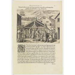
Argumentum I. Primus Lufitanorum cum Sogni praefecto congreffus, eiusdemque Baptismus, de quibus lib. 2 cap 2. fit mentio. (The arrival of the Portuguese in the county Sogno)
The arrival of the Portuguese in the county Sogno. When the Portuguese first discovered the county and the inhabitants of Sogno, they were taken for gods and received wit...
- $100 / ≈ €88
Place & Date: Frankfurt, 1598
Barbariae et Biledulgerid, nova descriptio.
North-West Africa. Koeman speculated: "In view of the important trading relationship between Antwerp and Africa, it is not impossible that the original was a manuscr...
Place & Date: Antwerp, 1598
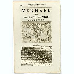
Presbiteri Johannis, sive Abissinorum Imperii descriptio.
Depicting Africa from the Mediterranean to the Mountains of the Moon placed just below Mozambique. Dare to go in Black. All early maps were printed in black and white,...
Place & Date: Antwerp, 1598

Fortezza di Gerbi.
Rare and early plan the fortress in present-day Jarbah Hawmat-as on the Tunisian island of Djerba, the largest African island in the Mediterranean.The fortress is still o...
- $2200 / ≈ €1937
Place & Date: Rome, 1586 / 1602

Africa.
A lovely miniature map of the continent of Africa, published by Petrus Bertius, in Amsterdam at the beginning of the seventeenth century. There is a small strap-work titl...
Place & Date: Amsterdam, 1606
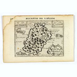
Sancta Helena.
An attractive small map of the south Atlantic island of St. Helena. Two years after the publication of Linschoten's Itinerario, the first map of St. Helena appeared in 15...
- $100 / ≈ €88
Place & Date: Amsterdam, 1606

Aegyptus.
A fine miniature map of Egypt, published by Petrus Bertius in Amsterdam early in the seventeenth century. The lovely map and has a strap-work title, in the lower left cor...
- $100 / ≈ €88
Place & Date: Amsterdam, 1606

Carthaginensis Sinus.
A beautifully miniature map by Petrus Bertius of the ancient city of Carthage and the more modern town of Tunis, first published in 1598. There are numerous features tha...
- $100 / ≈ €88
Place & Date: Amsterdam, 1606

Barbaria.
A nice miniature map of the north African region known as 'Barbary', published by Petrus Bertius in Amsterdam early in the seventeenth century. This lovely map also depic...
- $100 / ≈ €88
Place & Date: Amsterdam, 1606
Insulae et arcis Mocambique descriptio ad fines Melinde sita ebano puriss.
Attractive bird's-eye view of Melinde harbor in Mozambique showing the fortifications with numerous ships at anchor in the protected harbor. The map is finely engraved an...
- $300 / ≈ €264
Place & Date: Frankfurt, 1607
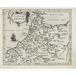
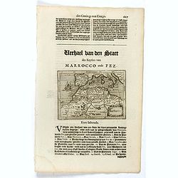
Fessae Regnum.
Charming small map of the northwestern tip of Africa with Fez showing as the principal city. Decorative title cartouche.From a Latin-text edition of Jodocus Hondius' Atla...
- $120 / ≈ €106
Place & Date: Amsterdam, 1608
Africae Descriptio.
Map of Africa from the first French-text edition of Jodocus Hondius' Atlas Minor.Shortly after the publication of the big folio-atlases the need was apparently felt for a...
Place & Date: Amsterdam, 1608
Insula D.Helenae sacra coeli Clementia . . .
A fine perspective view of the Island of St.Helena in the South Atlantic. The location of the Island directly on the navigation route from Europe to the Cape of Good Hope...
- $750 / ≈ €660
Place & Date: Frankfurt, 1609
Vera effigies et delineatio Infulce Ascenstio. . . (St. Helena)
Striking view of the Island of Ascuncion (St. Helena).Theodore de Bry, a German engraver and book dealer, began a compilation of early voyages in 1590 and had published s...
- $100 / ≈ €88
Place & Date: Frankfurt, 1609

XII. Delineatio Venationum, quomodo Nimir um Omnis Generis feras capiant. (How the hunters catch animals: 1603-1604)
A: shows a leopard walking into a cage with a trap door. B: is an antelope, killed by natives, using ‘assagais’. C: shows rabbits being caught. They are frightened ou...
- $125 / ≈ €110
Place & Date: Frankfurt, 1609
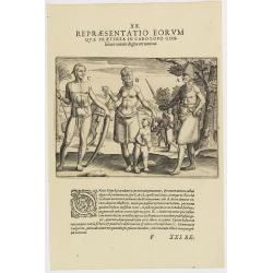
XX. Repraesentatio Eorum Quae Praeterea in Cabo Lopo Gonfalues. . . (More inhabitants of Cabo Lopo Gonsalues)
Here we see more figures of Cabo Lopo Gonsalues and Rio de Gabon. A: a distinguished man decked out in his finery and carrying several types of knives in his belt. In his...
- $100 / ≈ €88
Place & Date: Frankfurt, 1609
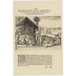
XIX. Repraesentatio Maiestatis, qua rex in Cabo Lopo Gonsalves . . . (How the chief of Cabo Lopo Gonsalues presents himself )
This describes the places they call Cabo Lopo Gonsalues and Rio de Gabon, where the chief receives his visitors. He sits on a chair placed upon a platform with two or thr...
- $100 / ≈ €88
Place & Date: Frankfurt, 1609
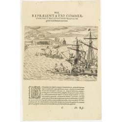
VIII. Repraesentatio Commerciorum et Negotiationum, Quas Nigritae cum Batauis exercent.
Locals from Gold Coast trying to sell items to the crew of a Dutch vessel. Theodore de Bry, a German engraver and book dealer, began a compilation of early voyages in 159...
- $100 / ≈ €88
Place & Date: Frankfurt, 1609
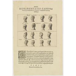
XXVI. Repraesentatio Capitum Praecipuarum Aliquot Personarum in Benyn.
Different types from Benin, in West Africa.Theodore de Bry, a German engraver and book dealer, began a compilation of early voyages in 1590 and had published six parts at...
- $75 / ≈ €66
Place & Date: Frankfurt, 1609
![[Madagascar].](/uploads/cache/37962-250x250.jpg)
[Madagascar].
Two text engravings from "Premier livre de l'histoire de la navigation aux Indes Orientales, par les hollandois, et des choses a eux advenues . . . ", being the...
- $125 / ≈ €110
Place & Date: Amsterdam, Cornille Nicolas, 1609
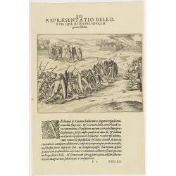
XXI. Repraesentatio Bellorum, Quae Aethiopes Invicem . . .
A fight between Ethiopian warriors.Theodore de Bry, a German engraver and book dealer, began a compilation of early voyages in 1590 and had published six parts at the tim...
- $75 / ≈ €66
Place & Date: Frankfurt, 1609
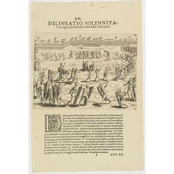
XVI. Delineatio Solennitatis, qua Nobiles Creari Solent.
Fine print of a Ceremony of electing or appointing a Nobleman in Guinea. Text below the engraving with an explanation in Latin : "During this ceremony there is a gre...
- $90 / ≈ €79
Place & Date: Frankfurt, 1609
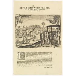
VII. Repraesentatio Processus in Iudiciis Civilibus et Criminalibus Ufitati. (Courts and Administration of Justice)
A depiction of the court and administration of justice. Seven features are identified : (A) the king or chief listening to a case presented to him, (B) the beheading of a...
- $90 / ≈ €79
Place & Date: Frankfurt, 1609
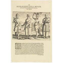
III. Repraesentatio Mullierum, et vestimentorum, Quibus Utuntur.
Inhabitants of the coast of the Ivory coast in Africa.Theodore de Bry, a German engraver and book dealer, began a compilation of early voyages in 1590 and had published s...
- $75 / ≈ €66
Place & Date: Frankfurt, 1609
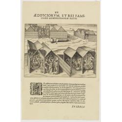
XV. Aedificiorum, et Rei Familiaris Administandae Ratio.
A village-scene in Guinea.Theodore de Bry, a German engraver and book dealer, began a compilation of early voyages in 1590 and had published six parts at the time of his ...
- $100 / ≈ €88
Place & Date: Frankfurt, 1609
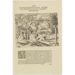
XIV. Repraesentatio Agriculturae et Fructuum Variorum exterra nafcentium.
Agriculture. Theodore de Bry, a German engraver and book dealer, began a compilation of early voyages in 1590 and had published six parts at the time of his death in 1598...
- $100 / ≈ €88
Place & Date: Frankfurt, 1609
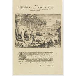
XIII. Repraesentatio Bestiarum ferarum Omnis Generis, quales in Guinea reperiuntur.
Fine engraving of Elephant and other wild animals. Theodore de Bry, a German engraver and book dealer, began a compilation of early voyages in 1590 and had published six ...
- $100 / ≈ €88
Place & Date: Frankfurt, 1609
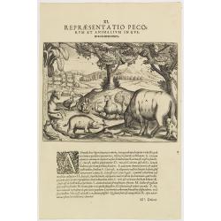
XI. Repraesentatio Pecorum et animalium in Guinea cicuratorum.
Various animals and birds from Africa. Engraved and published by Theodore de Bry, a German engraver and book dealer, began a compilation of early voyages in 1590 and had ...
- $100 / ≈ €88
Place & Date: Frankfurt, 1609
Africa ex magna orbis terre descriptione Gerardi Mercator. . .
A classic map of Africa. The map first appeared in Gerard Mercator’s Atlas sive Cosmographicae..., published posthumously in 1595. As stated in the title, this map is b...
- $2200 / ≈ €1937
Place & Date: Duisburg and then Amsterdam, (1595) 1609 or 1619

Tunetanum Regnum.
Small map representing Tunisia and Algeria, surrounded by text in Dutch.Nicolaes de Clerck (de Klerc) was active as engraver and publisher in Delft from 1599-1621.Include...
- $100 / ≈ €88
Place & Date: Amsterdam, Cloppenburch, 1621
Aegyptus.
Small map focused on the Nile Delta, where the Nile divides into several branches.Nicolaes de Clerck (de Klerc) was active as engraver and publisher in Delft from 1599-16...
- $100 / ≈ €88
Place & Date: Amsterdam, Cloppenburch, 1621
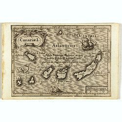
Canariae I.
Small map of the Canary Island. Nicolaes de Clerck (de Klerc) was active as engraver and publisher in Delft from 1599-1621.Included in the rare book : Wereld Spiegel, wae...
Place & Date: Amsterdam, Cloppenburch, 1621

Tunetanum Regnum.
Small map representing Tunisia and Algeria, surrounded by text in Dutch.Nicolaes de Clerck (de Klerc) was active as engraver and publisher in Delft from 1599-1621.Include...
Place & Date: Amsterdam, Cloppenburch, 1621

Aegyptus.
A small map focused on the Nile Delta, where the Nile divides into several branches.Included in the rare book : Wereld Spiegel, waer in vertoontword de Beschryvinge der R...
- $100 / ≈ €88
Place & Date: Amsterdam, Cloppenburch, 1621
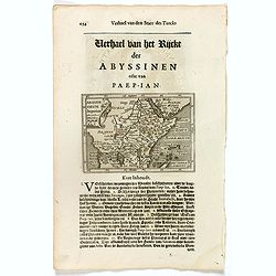
Abissinorum Imperium. / Acomath .I. Turcarum Imperator .XIIX. Ex Stirp. Ottomannica.
Map of central Africa. Copperplate engraving on text leaf with letterpress on verso. The engraving depicts a half length oval portrait of "Acomath I".Nicolaes d...
Place & Date: Amsterdam, Cloppenburch, 1621
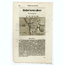
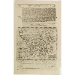
Congo Regnum Christian. In Africa.
Small map illustrating the western seashores of Central Africa, surrounded by text in Dutch.Nicolaes de Clerck (de Klerc) was active as engraver and publisher in Delft fr...
Place & Date: Amsterdam, Cloppenburch, 1621
Barbaria.
Small map illustrating the eastern part of the Mediterranean Basin, namely the African side. Surrounded by text in Dutch.Nicolaes de Clerck (de Klerc) was active as engra...
- $75 / ≈ €66
Place & Date: Amsterdam, Cloppenburch, 1621

Aegyptus.
The rare Samuel Purchas' edition of the Mercator/Hondius Atlas Minor atlas map. Early map of Egypt published in his famous collection of voyages His Pilgrimes . With desc...
- $150 / ≈ €132
Place & Date: London, 1625
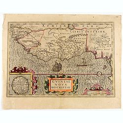
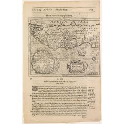
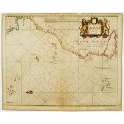
Guineae Nova Descriptio.
The map shows the West African coast from Senegal (the 'Rio Senega' is the Senegal River) to Cape Lopez on the Gulf of Guinea just below the equator.The island of St. Tho...
- $700 / ≈ €616
Place & Date: Amsterdam, 1628
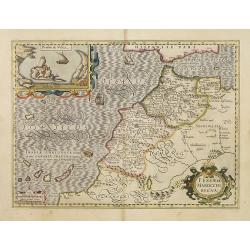
Fessae et Marocchi Regna.
One of the new maps added by Hondius, when he took over publication of the Atlas, a finely engraved and decorative map of north-west Africa, with the Canaries. With an in...
Place & Date: Amsterdam, 1630
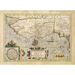
Guineae Nova Descriptio.
The map shows the West African coast from Senegal (the 'Rio Senega' is the Senegal River) to Cape Lopez on the Gulf of Guinea just below the equator. The island of St. Th...
- $450 / ≈ €396
Place & Date: Amsterdam, 1630

Africa ex magna orbis terre descriptione Gerardi Mercator. . .
Map of Africa. Much of the interior of Africa defers to the traditions of Ptolemy. The Nile river is shown with the two lakes and the Mountains of the Moon across souther...
Place & Date: Amsterdam, 1630
Selling price: $1500
Sold in 2015
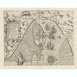
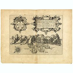
![[Attack of Dutch fleet commanded by Pieter van der Does of Gran Canaria in 1599].](/uploads/cache/40179-250x250.jpg)
[Attack of Dutch fleet commanded by Pieter van der Does of Gran Canaria in 1599].
Attack of Dutch fleet commanded by Pieter van der Does of Gran Canaria in 1599. Scarce print (150x177mm.) on a German text sheet taken from a first edition of Johann Ludw...
- $180 / ≈ €158
Place & Date: Frankfurt, M.Merian, 1633
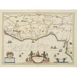
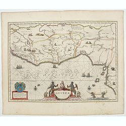
Guinea.
An attractive map covered with intersecting rhumb lines and decorated with monkeys, lions, elephants and native figures. With a dedication to Dr. Nicolas Tulp.As Willem B...
- $750 / ≈ €660
Place & Date: Amsterdam, 1638
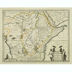
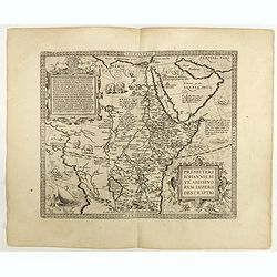
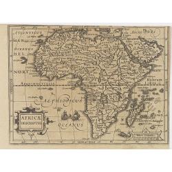
Aethiopia Superior vel Interior vulgo Abissinorum.
An attractive map of Eastern Africa and the fictitious kingdom of Prester John. The map shows a major section of central and eastern Africa including Mozambique north to ...
- $450 / ≈ €396
Place & Date: Amsterdam, 1638

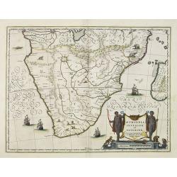
Aethiopia Inferior vel Exterior.
The standard map of South Africa throughout the 17th century. The lake out of which the 'Zambere' -the Zambesi- flows is probably based on reports of Lake Ngami, undiscov...
- $750 / ≈ €660
Place & Date: Amsterdam, 1640
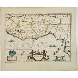
Guinea.
An attractive map covered with intersecting rhumb lines and decorated with monkeys, lions, elephants and native figures. With a dedication to Dr. Nicolas Tulp.
- $750 / ≈ €660
Place & Date: Amsterdam, 1640

Barbaria. / Egypt / Tunesia.
Three maps on one sheet. Upper part, it shows the coast of Barbaria from Morocco to Egypt: the map on the left corner of Tunis includes a plan of Goletiae, and the right ...
- $300 / ≈ €264
Place & Date: Amsterdam, 1641

Fezzae et Marocchi regna Africae celeberrima.
North to the right. Showing the Atlas Mountains in the south to the southern coast of Spain, along the coast at Ceuta, Tangiers, and Arzilla.A finely engraved, decorative...
- $500 / ≈ €440
Place & Date: Amsterdam, 1644
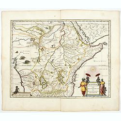
Aethiopia Superior vel Interior vulgo Abissinorum.
An attractive map of the Eastern African and the fictitious kingdom of Prester John. The map shows a major section of central and eastern Africa including Mozambique nort...
- $700 / ≈ €616
Place & Date: Amsterdam, 1644

Aethiopia inferior, vel exterior.
The standard map of South Africa throughout the 17th century. The lake out of which the 'Zambere' -the Zambesi- flows is probably based on reports of Lake Ngami, undiscov...
- $1100 / ≈ €969
Place & Date: Amsterdam, 1644
Guinea.
An attractive map covered with intersecting rhumb lines and decorated with monkeys, lions, elephants and native figures. With a dedication to Amsterdam anatomist and phys...
- $750 / ≈ €660
Place & Date: Amsterdam, 1644

Aethiopia inferior, vel exterior.
The standard map of South Africa throughout the 17th century. The lake out of which the 'Zambere' -the Zambesi- flows is probably based on reports of Lake Ngami, undiscov...
- $575 / ≈ €506
Place & Date: Amsterdam, 1645
Guinea.
Samuel Purchas' edition of the Mercator/Hondius Atlas Minor . Map of Guinea published in his famous collection of voyages His Pilgrimes . With descriptive text in English...
Place & Date: London, 1645
Congi regnu.
Samuel Purchas' edition of the Mercator/Hondius Atlas Minor . Early map of Congo published in his famous collection of voyages His Pilgrimes . With descriptive text in En...
- $100 / ≈ €88
Place & Date: London, 1645
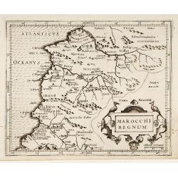
Marocchi Regnum.
From the Mercator/Hondius Atlas Minor. Early map of Morocco.
Place & Date: Amsterdam, 1645
Aethiopia inferior, vel exterior.
The standard map of South Africa throughout the 17th century. The lake out of which the 'Zambere' -the Zambesi- flows is probably based on reports of Lake Ngami, undiscov...
- $575 / ≈ €506
Place & Date: Amsterdam, 1645

Fille Moresque esclave en Alger ville de Barbarie. (63)
Sought-after copper engraved plate of a young slave from Algeria. Plate from Laonikos Chalcocondyle’s "L'histoire de la décadence de l'empire grec et establisseme...
- $45 / ≈ €40
Place & Date: Paris, Mathieu Guillemot, 1650

Femme moresque de Tripoly en Barbarie. (60)
Sought-after copper engraved plate of a woman with child from Tripoli. Plate from Laonikos Chalcocondyle’s "L'histoire de la décadence de l'empire grec et establi...
- $45 / ≈ €40
Place & Date: Paris, Mathieu Guillemot, 1650

Esclave More. (38)
Sought-after copper engraved plate of a Moor slave from North Africa. Plate from Laonikos Chalcocondyle’s "L'histoire de la décadence de l'empire grec et establis...
- $75 / ≈ €66
Place & Date: Paris, Mathieu Guillemot, 1650

Aethiopia inferior, vel exterior.
The standard map of South Africa throughout the 17th century. The lake out of which the 'Zambere' -the Zambesi- flows is probably based on reports of Lake Ngami, undiscov...
- $800 / ≈ €704
Place & Date: Amsterdam, ca. 1660

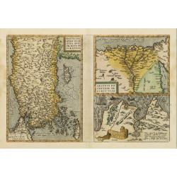
L'Affrique En Plusieurs Cartes Nouvelles, et exactes, &c.
Edition illustrated with 18 maps in original outline colors dated 1656. No date and title page and maps not numbered (according to Pastoureau 1 C, maps are numbered).Nico...
Place & Date: Paris, l'Auteur, after 1662
De Cust van Barbaria, Gualata, Arguyn, en Gene..heo, van Capo S.Vincente tot Capo Verde.
An eye-catching chart of the north western coast of Africa. Including Canary Islands, Cape Verde Islands and Azores.Pieter Goos (ca. 1616-1675) was one of the most import...
Place & Date: Amsterdam, 1666
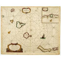
.Caarte voor een gedeelte der Canarise Eylanden als Canaria, Tenerifa, Forteventura, etc.
Very rare chart of the Canaries. Showing Palma, Ferro, Tenerife, Gran Canaria, Forteventura, Lancerota. In upper right hand corner inset of harbour of Lancerota.
- $1000 / ≈ €880
Place & Date: Amsterdam, 1666
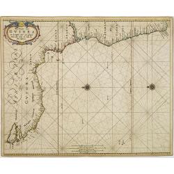
Pas-Caart van Guinea en den Custen daer aen gelegen Van C..
A decorative chart of the southwest coast of Africa, embellished with an elaborate, finely colored title-cartouche, and 2 compass-roses. Pieter Goos (ca. 1616-1675) was o...
Place & Date: Amsterdam, 1666