Browse Listings

Giuoco dell' Oca. La tentazione
Uncommon Italian Game of the Goose in 90 boxes. The rules of the game are explained as follows: "REGOLA DEL GIUOCO: Questo giuoco è composto di 90 numeri e può ser...
- $250 / ≈ €220
Place & Date: Italy, ca. 1900
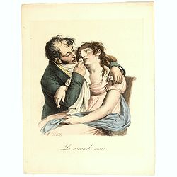
Le Second Mois. (The second month).
Lithograph depicting a woman suffering and her husband supporting her with the early pregnancy sicknesses.Belonging to the series "LES GRIMACES" by Louis-Léopo...
- $50 / ≈ €44
Place & Date: Paris, c. 1830-1900

Le Neuvieme Mois.
Lithograph depicting a woman and her husband awaiting for the childbirth moment.Belonging to the series "LES GRIMACES" by Louis-Léopold Boilly (1761-1845), lit...
- $50 / ≈ €44
Place & Date: Paris, c. 1830-1900
![Drehbare Tasschen Sternkarte Brieftasche Format . . . [Calendrier perpetuel]](/uploads/cache/44965-250x250.jpg)
Drehbare Tasschen Sternkarte Brieftasche Format . . . [Calendrier perpetuel]
Calendrier perpetual prepared and published by Otto Maier in Regensburg. This "Rotatable Cosmos Star Chart" shows in no time the currently visible sky detail. Y...
- $200 / ≈ €176
Place & Date: Regensburg, ca. 1900
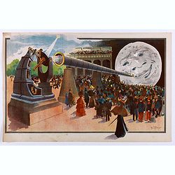
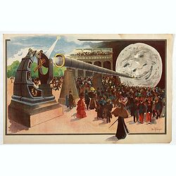
La Lune à un Mètre [Mini poster for Paris Exposition Universelle)
Original lithograph poster for "Paris Exposition Universelle" held between April and November, 1900, which received 50 million visitors. In 1899, director Geor...
Place & Date: Paris, c.1900
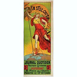
La Volonté - Journal politique et littéraire.
Advertising poster for the French newspaper La Volonté, made by Armand Point and printed by Imp. Vercasson. Showing Mercury standing on the globe showing the European pa...
- $700 / ≈ €616
Place & Date: Paris, ca. 1900
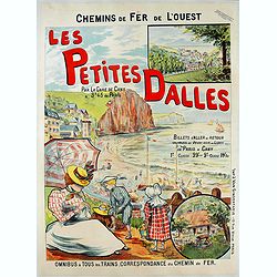
Les petites dalles.
Advertising poster for Chemins de fer de l’ouest, made by Fernel and printed by J. Van Gindertaele, Paris.Les Petites-Dalles is located in a valley on the Alabaster coa...
- $900 / ≈ €792
Place & Date: Paris, ca. 1900
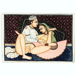
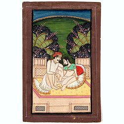
Indian painting on ivory
Fine oriental miniature of an amourouse Indian couple. Drawing, brush and gouache on ivory panel, late 19th/ early 20th cent.
Place & Date: India, ca. 1900
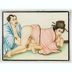
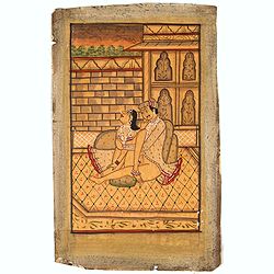
Indian painting on ivory
Fine oriental miniature of an Japanese looking couple. Drawing, brush and gouache on ivory panel, late 19th/ early 20th cent.
Place & Date: India, ca. 1900
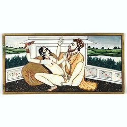
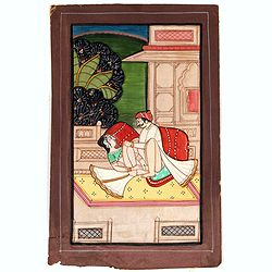
Indian painting on ivory
Fine oriental miniature of a amorous scene of an Indian couple with a landscape in the back. Drawing, brush and gouache on ivory panel, late 19th/ early 20th cent.
Place & Date: Iran, India, ca. 1900
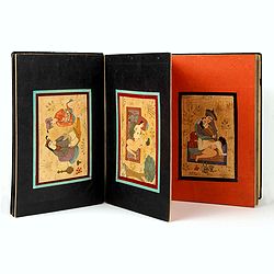
Eight Indian paintings, accordion mounted.
SUPERB SET of eight remarkable free miniatures, presenting couples in natural decorations. The miniatures are painted in Iran or India in late 19th - early 20th century]....
Place & Date: Iran, India, ca. 1900
Indian painting on paper.
Fine miniature, presenting a couple in love making position, set on a balcony with in a landscape in the background. The miniature has been painted in India in late 19th ...
Place & Date: India, ca. 1900
Indian painting on paper.
Fine miniature, presenting a couple in love making position, set in an interior. The miniature has been painted in India in late 19th - early 20th century. The miniature ...
- $150 / ≈ €132
Place & Date: India, ca. 1900
Indian erotic painting on paper.
Fine miniature, presenting a couple in a love-making position, set on a balcony within a landscape in the background. The miniature was painted in India in the late 19th ...
- $250 / ≈ €220
Place & Date: India, ca. 1900

Indian painting on paper of a couple in a love-making position.
Fine miniature, presenting a couple in a love-making position. The miniature was painted in India in the late 19th - early 20th century. The miniature is 165 x 108 mm, pa...
- $100 / ≈ €88
Place & Date: India, ca. 1900

Indian painting on paper of a couple in a love-making position.
Fine miniature, presenting a couple in a love-making position, set on a balcony with in a landscape in the background. The miniature was painted in India in the late 19th...
Place & Date: India, ca. 1900

Carte routière de France de Dion Bouton spéciale pour automobiles
Highly decorative folding wall map of France in a scale of 1 : 800 000. In the upper left hand corner an inset plan of Paris, upper right Algeria and lower right map of C...
- $1500 / ≈ €1321
Place & Date: Paris, J. Barreau, 1900

Carte nationale des routes de la France.
Map of the national roads in France, engraved and published by Regnier et Dourdet. Four inset maps of which three shows the three largest cities in France and one shows C...
- $75 / ≈ €66
Place & Date: Paris, ca. 1900
![Le Malade Imaginaire. [Plate 48]](/uploads/cache/47424-250x250.jpg)
Le Malade Imaginaire. [Plate 48]
Illustration from the "Le Malade Imaginaire" by Félix Lorioux . This plate 48 has a caption that roughly translates as: "I hear some great news", Mr ...
Place & Date: Paris, ca. 1900
![Le Malade Imaginaire. [Plate 61]](/uploads/cache/47425-250x250.jpg)
Le Malade Imaginaire. [Plate 61]
Humorous illustration from the "Le Malade Imaginaire" by Félix Lorioux. This Plate 61 has a caption that reads: "A doctor, having posed a question to Arga...
Place & Date: Paris, ca. 1900
![Le Malade Imaginaire. [Plate 6]](/uploads/cache/47426-250x250.jpg)
Le Malade Imaginaire. [Plate 6]
Humorous illustration from the "Le Malade Imaginaire" by Félix Lorioux . This plate 6 has a caption that roughly translates "There was not a day when Arga...
Place & Date: Paris, ca. 1900
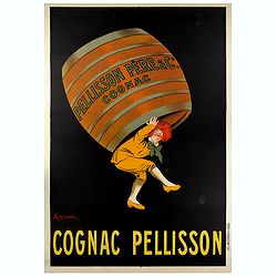
COGNAC PELISSON.
Original advertising poster for the French cognac brand Pellisson, printed by Imprimerie Vercasson, in Paris, designed by Leonetto Cappiello. Leonetto Cappiello, born in ...
Place & Date: Paris, ca. 1900
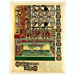
Championnat international de natation.
Uncut sheet for a game for kids " Championnat international de notation", showing images of swimmers donned in swimsuits representing their respective countri...
- $350 / ≈ €308
Place & Date: Saussine, Paris, 1900
![[Game of the goose] Het nieuw vermakelijk ganzenspel. Le nouveau jeu d'Oie.](/uploads/cache/48331-250x250.jpg)
[Game of the goose] Het nieuw vermakelijk ganzenspel. Le nouveau jeu d'Oie.
Game of 63 boxes, spiral, counter clockwise. Goose board game with spiral with 63 numbered squares. In different boxes a representation of a goose. In a box on the center...
- $100 / ≈ €88
Place & Date: Turnhout, ca.1900
La Lune à un Mètre (Mini poster for Paris Exposition Universelle)
Original chromo-lithograph mini poster for "Paris Exposition Universelle" held between April and November, 1900, which received 50 million visitors. In 1899, ...
- $900 / ≈ €792
Place & Date: Paris, c.1900
![[Game of the goose] Nouveau Jeu des Singes.](/uploads/cache/48327-250x250.jpg)
[Game of the goose] Nouveau Jeu des Singes.
Game of 30 boxes, spiral, counter clockwise, showing apes and in the center apes enjoying a dinner. The example was made by "Imagerie d'Epinal" and in upper rig...
- $150 / ≈ €132
Place & Date: Epinal, ca.1900
![[Game of the goose] Het nieuw vermakelijk ganzenspel. Le nouveau jeu d'Oie.](/uploads/cache/48365-250x250.jpg)
[Game of the goose] Het nieuw vermakelijk ganzenspel. Le nouveau jeu d'Oie.
Game of 63 boxes, spiral, counter clockwise. Goose board game with spiral with 63 numbered squares. In different boxes a representation of a goose. In a box on the center...
- $100 / ≈ €88
Place & Date: Turnhout, ca.1900
![[Board game] - La course autour du Monde.](/uploads/cache/48521-250x250.jpg)
[Board game] - La course autour du Monde.
Very rare French board game - no other copies known. The game consists of 50 fields linked to the lines of longitude. A globe lies in the center of the board to symboli...
Place & Date: Paris, ca. 1900

Anamorphose.
Perspective anamorphosis is an ingenious perspective technique that gives a distorted image of the subject represented in a picture when seen from the usual viewpoint but...
- $750 / ≈ €660
Place & Date: Paris, ca. 1900
Anamorphose.
Perspective anamorphosis are an ingenious perspective technique that gives a distorted image of the subject represented in a picture when seen from the usual viewpoint bu...
- $750 / ≈ €660
Place & Date: Paris, ca. 1900
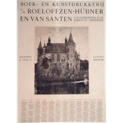
Kasteel Heeswijk.
Very fine etching of the Castle of Heeswijk, by the well-known etcher Ludwig Willem Reymert Wenckebach. He was born in The Hague on 12 January 1860 and died in 1937. The ...
Place & Date: Amsterdam, 1901

Peking. ( Pictorial map)
This pictorial map of this Game of the Goose, published at the time of the Boxer War, shows well the situation of Pei-Ho and Tientsin in relation to Peking. There are 42 ...
- $600 / ≈ €528
Place & Date: France, ca.1901
COLLECTION OF HONG KONG MAPS, BOOKS & FLYERS. Including CHINA - HONGKONG surveyed by Captn. Sir Edward Belcher, in H.M.S. Sulphur 1841. Corrected to 1901.
A collection of 30 maps, prints, and publications relating to Hong Kong. Including : - BELCHER, E. Sir, An updated version of this most important nautical chart of Hong K...
Place & Date: London, 1841 - 1901
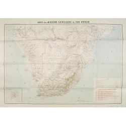
Carte des Missions Catholiques du Sud Africain.
Map of the Catholic Missions in South Africa. Inset map of L'Ile St. Hélène.Published as supplement of the Les Missions Catholiques. To the lower right an inset key to ...
Place & Date: Paris, Monrocq, 1902
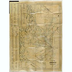
Plano de los Ferro-Carriles de Republica Argentina 1902.
Folding rail road map of Argentina, with inset of Buenos Aires in upper right corner.
Place & Date: Buenos Aires, ca. 1902

Philippine Islands and Hawaii.
Map of Philippine Islands and Hawaii, with inset maps of Manila, Honolulu, and Pearl Harbor, circa 1902, from the 10th edition of Encyclopaedia Britannica.
- $40 / ≈ €35
Place & Date: London, ca. 1902
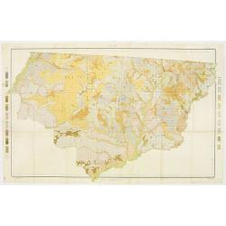
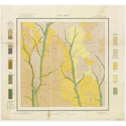
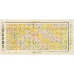
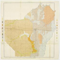
Soil map - Florida, Gadsden County sheet.
Early color lithographed soil map by Julius Bien & Co. in New York for the Department of Agriculture. Legends at the side give detail on soil type, etc. They also inc...
- $40 / ≈ €35
Place & Date: New York, 1903
Soil map - South Carolina Campobello Sheet.
Early color lithographed soil map by Julius Bien & Co. in New York for the Department of Agriculture. Legends at the side give detail on soil type, etc. They also inc...
- $50 / ≈ €44
Place & Date: New York, 1903
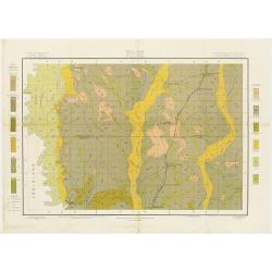
Soil map - Virginia Norfolk Sheet.
Soil map printed by Julius Bien & Co. in New York for the Department of Agriculture. The map gives great detail of the area centered on Norfolk, Potsmouth, Chesapeake...
- $50 / ≈ €44
Place & Date: New York 1903
![[Soil map] Virginia-Maryland-West Virginia, Leesburg sheet.](/uploads/cache/23257-250x250.jpg)
[Soil map] Virginia-Maryland-West Virginia, Leesburg sheet.
Early color lithographed soil map by Julius Bien & Co. in New York for Department of Agriculture. Legends at side give detail on soil type, etc. They also include int...
Place & Date: New York, 1903

Soil map - Pennsylvania, Lockhaven sheet.
Early color lithographed soil map by Julius Bien & Co. in New York for Department of Agriculture. Legends at side give detail on soil type, etc. They also include int...
- $50 / ≈ €44
Place & Date: New York, 1903
Soil map - Connecticut. - Massachusetts, (Hartford) Springfield sheet.
Early color lithographed soil map by Julius Bien & Co. in New York for Department of Agriculture. Legends at side give detail on soil type, etc. They also include int...
Place & Date: New York, 1903
Selling price: $85
Sold in 2008
Soil map - Texas, Nacogdoches sheet.
Early color lithographed soil map by Julius Bien & Co. in New York for Department of Agriculture. Legends at side give detail on soil type, etc. They also include int...
- $75 / ≈ €66
Place & Date: New York, 1903
Soil map - Georgia, Fort Valley sheet.
Early color lithographed soil map by Julius Bien & Co. in New York for Department of Agriculture. Legends at side give detail on soil type, etc. They also include in...
- $50 / ≈ €44
Place & Date: New York, 1903
Soil map - Mississippi, McNeill sheet.
Soil map printed by Julius Bien & Co in New York for Department of Agriculture. The map is giving great detail of the area McNeill, Mississippi, in the year 1903. Soi...
- $50 / ≈ €44
Place & Date: New York, 1903
Soil map - Louisiana, Ouachita sheet.
Early color lithographed soil map by Julius Bien & Co. in New York for Department of Agriculture. Legends at side give detail on soil type, etc. They also include int...
- $40 / ≈ €35
Place & Date: New York, 1903
![Wusung River or Hwang Pu. / Wusung River Entrance [With Shanhhai]](/uploads/cache/48595-250x250.jpg)
Wusung River or Hwang Pu. / Wusung River Entrance [With Shanhhai]
A fine Survey chart no. 1601 showing Wusung River or Hwang Pu. / Wusung River Entrance [With Shanghai]
- $800 / ≈ €704
Place & Date: London, 1887 - 190, updated to 1903
CANTON Kong-Teheou.
Very detailed (1:1.000.000) map centered on Macao and Victoria Island, showing soundings, English, Australian, Danish telegraph lines reaching Hong Kong and extended to M...
Place & Date: Paris, 1898 updated for june 1904

Sul teatro della guerra (L'entusiasmo patriottico dei Russi) - Rana N. 10 (Cent.10) - Sur le théâtre de la guerre (enthousiasme patriotique des Russes).
Satirical depiction of the Russo-Japanese war, which began in February 1904,we can see the opposed armies of the Russian and those of the Japanese Empire for the control ...
- $750 / ≈ €660
Place & Date: Bologna, 11 March 1904

Übersichtskarte von Ost-Asien im Maßstabe 1: 5.000.000 mit 14 Beikarten in großen Maßstäben . . .
A large, uncommon map of East Asia prepared by Karl Peucker, and published by Ataria & Co. Striking and heavily annotated with information on China, Korea, Japan, and...
Place & Date: Vienna, Artaria, 1904

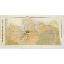
Plan des paroisses de Paris avec la distinction des parties éparses qui en dépendent dressé... par J. Junié, Ingén. Géogr. De Monseigneur l'Archeveque et géomètre des Eaux et forêts de ...
Large wall map size plan of Paris in 4 separate sheets, if joined forming a plan of Paris of 93 x 60cm. This plan is a 1904 version of a manuscript plan drawn in 1786 by ...
Place & Date: Paris, Service des Travaux historiques de la Ville de Paris, 1904
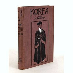
Korea. Das Land des Morgenrots. Nach seinen Reisen geschildert von Angus Hamilton. Autorisierte Übersetzung aus dem Englischen.
With 114 illustrations after photographes and one map.
- $175 / ≈ €154
Place & Date: Leipzig: Spamer, 1904
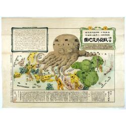
A Humorous Diplomatic Atlas of Europe and Asia. / 滑稽欧亜外交地図 / Kokkei Ō-A Gaikō Chizu.
A wonderful example of the rare 1904 Kisaburo Ohara satirical 'Octopus Map' of Europe being swallowed by an octopus (Russia). Composed at the outbreak of the Russo-Japane...
Place & Date: Tokyo, April, 1904

Map of the Far East
rare map including, Corea, Japan and China, prepared by Leonid Ivanovich Borodovsky, (1870-1906) and published in 1904. This folding map has several insets, one with Tai...
- $1000 / ≈ €880
Place & Date: St. Petersburg, A.Ilyin, 1904
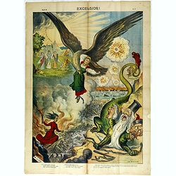
Excelsiori (Rana N. 28 - Cent. 20).
"After so many wars and so many troubles, young Russia, in a more serene glaze all the beautiful sun of freedom you will enjoy ... ". Fascinating allegorical sa...
Place & Date: Bologna, 1905
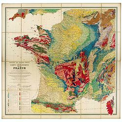
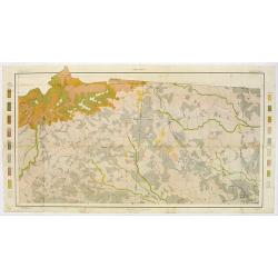
Carte géologique de la France.
Early geological map of France, published by Charles Béranger. Full title: " Ministère des Travaux publics, Carte géologique de la France 1:1'000'000, Exécutée ...
- $1200 / ≈ €1057
Place & Date: Paris, 1905
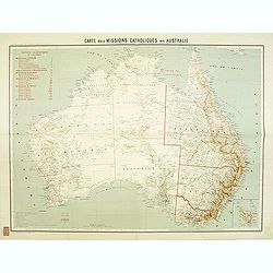
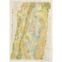
Carte des missions Catholiques en Australie.
Rare and detailed map of Australia (Scale 1:5 000 000) showing Catholic dioceses and bishops' residences, but not missions, on a topographic basis. Relief is shown by hac...
- $900 / ≈ €792
Place & Date: Lyon / Paris, 1906
Parliamentary Papers - Foreign Office - Annual Series - Diplomatic and Consular Reports on Trade and Finance.
Very scarce - Only for the British Parliament and the British Crown printed - and not for the trade! Accounts about the Korean country during the time span of the last th...
Place & Date: London, Harrison and Sons, 1882-1906
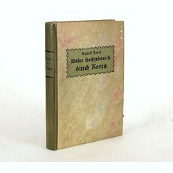
Meine Hochzeitsreise durch Korea während des Russisch-japanischen Krieges.
Illustrated with ca. 200 illustrations. All photographs are taken by the author.
Place & Date: Altenburg, S.-A., Stephan Geibel Verlag, 1906
L'illustration, journal officiel hebdomadaire.
L'Illustration, the first French illustrated newspaper from 1843, became the first magazine in the world in 1906 and is distributed in more than 150 countries.The mythica...
Place & Date: Paris, 1908
![Manila the perl of the Orient. Guide book to the intending visitor [with several photos and 3 plans of Manila]](/uploads/cache/48356-250x250.jpg)
Manila the perl of the Orient. Guide book to the intending visitor [with several photos and 3 plans of Manila]
Charming 1908 Guide book to with several photos and 3 folding plans of Manilla. Published by the "Manila merchants' association", directed by O'Connell, Daniel....
Place & Date: Manilla, 1908
Karta Evropeiskoi Rossii i Sibirii na 4 listakh [ Map of European Russia and Siberia in 4 sheets compiled and based on the most advanced statistical and geographical information.]
A fine large map showing Eastern Europe from Stockholm to Constantinople, with Russia eastward from Perm and south to the Caucasus and Iran. With indications of judicial ...
- $750 / ≈ €660
Place & Date: Saint Petersburg, 1908
![[Tartary - Russia]](/uploads/cache/44310-250x250.jpg)
[Tartary - Russia]
Postcard size map in Ottoman script showing Siberia prepared by Mehmet EŞREF in a small atlas : عمومولاياةىشهانيىحاوىكوچكاطلاس [Umum-i vil...
- $75 / ≈ €66
Place & Date: Istanbul, 1325 or 1909
![[Australia and New Zealand map with Ottoman script.]](/uploads/cache/44313-250x250.jpg)
[Australia and New Zealand map with Ottoman script.]
Post card size map in Ottoman script showing Australia and New Zealand prepared by Mehmet EŞREF in a small atlas : عمومولاياةىشهانيىحاوىكوچكا�...
- $225 / ≈ €198
Place & Date: Istanbul, 1325 or 1909
![[United States map with Ottoman script.]](/uploads/cache/44314-250x250.jpg)
[United States map with Ottoman script.]
Postcard size map in Ottoman script showing the United States prepared by Mehmet EŞREF in a small atlas : عمومولاياةىشهانيىحاوىكوچكاطلاس [...
- $175 / ≈ €154
Place & Date: Istanbul, 1325 or 1909
![[Persia, Afghanistan and Pakistan map with Ottoman script]](/uploads/cache/44316-250x250.jpg)
[Persia, Afghanistan and Pakistan map with Ottoman script]
Postcard size map in Ottoman script showing Persia, Afghanistan and Pakistan prepared by Mehmet EŞREF in a small atlas : عمومولاياةىشهانيىحاوىكو�...
- $150 / ≈ €132
Place & Date: Istanbul, 1325 or 1909
![[Asia map with Ottoman script]](/uploads/cache/44317-250x250.jpg)
[Asia map with Ottoman script]
Postcard size map in Ottoman script showing Asia, prepared by Mehmet EŞREF in a small atlas : عمومولاياةىشهانيىحاوىكوچكاطلاس [Umum-i vilay...
- $150 / ≈ €132
Place & Date: Istanbul, 1325 or 1909
![[Australia, New Zealand and Oceania map with Ottoman script]](/uploads/cache/44319-250x250.jpg)
[Australia, New Zealand and Oceania map with Ottoman script]
Postcard size map in Ottoman script showing Australia, New Zealand and Oceania prepared by Mehmet EŞREF in a small atlas : عمومولاياةىشهانيىحاوىك�...
- $175 / ≈ €154
Place & Date: Istanbul, 1325 or 1909
![[Mexico map with Ottoman script]](/uploads/cache/44321-250x250.jpg)
[Mexico map with Ottoman script]
Postcard size map in Ottoman script showing Mexico, including Texas prepared by Mehmet EŞREF in a small atlas : عمومولاياةىشهانيىحاوىكوچكاطل...
- $150 / ≈ €132
Place & Date: Istanbul, 1325 or 1909
![[World map in showing currents with Ottoman script]](/uploads/cache/44322-250x250.jpg)
[World map in showing currents with Ottoman script]
Post card size world map in Mercator projection showing the currents in Atlantic and Pacific Oceans in Ottoman script prepared by Mehmet EŞREF in a small atlas : عمو...
- $150 / ≈ €132
Place & Date: Istanbul, 1325 or 1909
![[Set of two maps in north and south pole projections, with orographic profile of mountains and oceans, with volcanos with Ottoman script]](/uploads/cache/44325-250x250.jpg)
[Set of two maps in north and south pole projections, with orographic profile of mountains and oceans, with volcanos with Ottoman script]
Two postcard size maps with north and south pole projections, below each map orographic profiles of mountains and oceans, with volcanos. The maps are in Ottoman script pr...
- $200 / ≈ €176
Place & Date: Istanbul, 1325 or 1909
![[Set of two maps showing world in Mercator projection, with Ottoman script]](/uploads/cache/44328-250x250.jpg)
[Set of two maps showing world in Mercator projection, with Ottoman script]
Two postcard size maps showing the entire world in Mercator projection. The maps are in Ottoman script prepared by Mehmet EŞREF in a small atlas : عمومولاياة�...
- $200 / ≈ €176
Place & Date: Istanbul, 1325 or 1909
![[ North and South America with telegraph cables, with Ottoman script]](/uploads/cache/44330-250x250.jpg)
[ North and South America with telegraph cables, with Ottoman script]
Postcard size map showing North and South America with telegraph cables. The map is in Ottoman Arabic-script prepared by Mehmet EŞREF in a small atlas : عمومولا�...
- $190 / ≈ €167
Place & Date: Istanbul, 1325 or 1909

General Karte von Asien. Entworfen und gezeichnet von F. Handtke.
In upper left corner "Carl Flemmings Generalkarten No. / Nr. 37" in a 17th edition. Prepared by Friedrich Handtke (1815-1879). Scale 1: 18.886.000, with a key i...
Place & Date: Glogau, Carl Flemming, c.1910
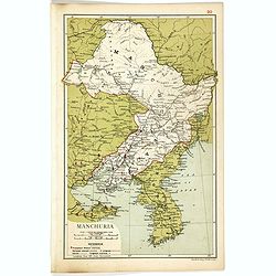
Manchuria.
Map of Manchuria and Korea. With in lower left corner scales in miles and kilometers, Protestant Mission Stations, railways both opened and in progress, canals and telegr...
- $75 / ≈ €66
Place & Date: London, 1910

Giuoco Dell'Oca Geografica.
An attractive and rare playing board for a “Goose game” designed to teach the geographical places of Italy.The Game of the Goose is a race game wherein players move t...
Place & Date: Italy, ca. 1910
Selling price: $160
Sold in 2018
![[Set of six postcards] La Comète 1910 / Komet 1910.](/uploads/cache/44401-250x250.jpg)
[Set of six postcards] La Comète 1910 / Komet 1910.
Complete set of six postcards commemorating Halley's Comet in 1910. Numbered on verso 1 to 6, Verlag Koch & Bitriol Serie 3090 Bild 6 AK. Designed by K. Hesse. The ye...
Place & Date: Dresden, Koch & Britriol, 1910

Boucle du Pei-Ho.
Manuscript map of Boucle du Pei-Ho (Taku Forts) showing the river Pei-ho, along with the projected railway lines were to be built, including bridges, installations, villa...
- $750 / ≈ €660
Place & Date: China ?, ca.1910
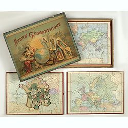
Atlas Geographique. (Puzzle).
Three map puzzles, each measuring 25 x 33 cm., housed in the original color printed card case. Geographical jigsaw puzzle set comprising three maps (world, Europe and Fra...
Place & Date: Paris, ca. 1910
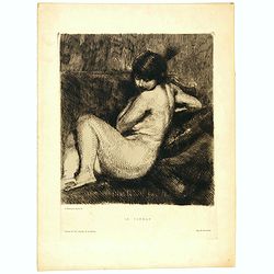
Le Turban.
Etching in brown ink on cream laid paper by Albert Besnard (1849–1934) of a young naked woman with feathered turban. Inscribed below the borderline: (left) “A. Besnar...
Place & Date: Paris, 1910