Search Listings matching "ukraine"
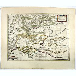
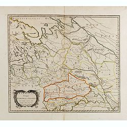
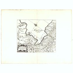
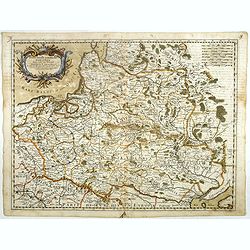
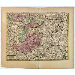
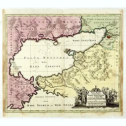
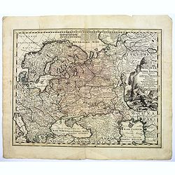
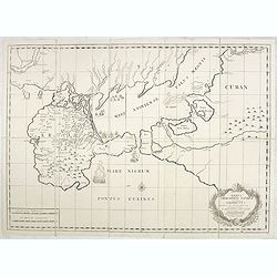
Secunda Asiae Tabula (Ukraine and Russia)
Woodblock printed a large-format Ptolemaic map showing Russia, Ukraine, and the Black Sea region. From the 1513 edition of Waldseemüller's Geographia.One of the earliest...
Place & Date: Strasburg, 1513
![Tabula III Asiae. [Caucass and Armenia.]](/uploads/cache/47571-250x250.jpg)
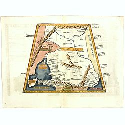
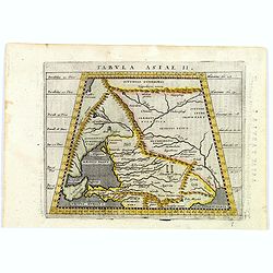
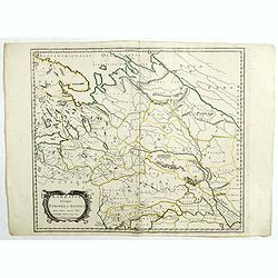
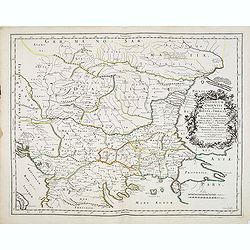
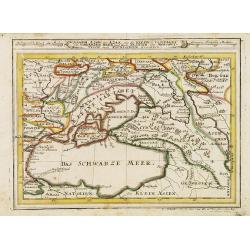
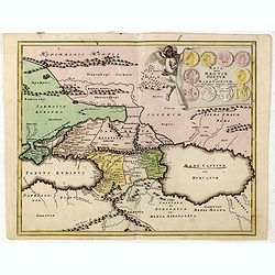
Tabula III Asiae. [Caucass and Armenia.]
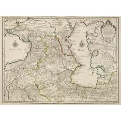
Ptolemaic map of the region south of the Caucasus Mountains and between the Caspian Sea as far south as the headwaters of the Tigris River in the south and the Black Sea,...
- $750 / ≈ €661
Place & Date: Lyons, M. Servetus, 1525
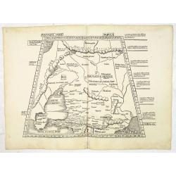
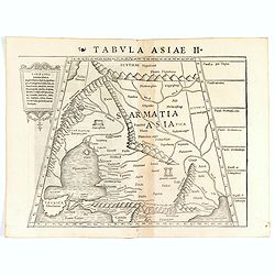
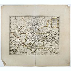
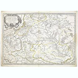
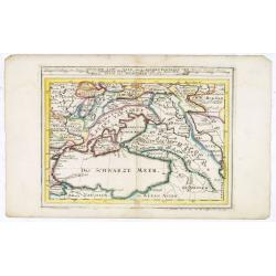
Tabula II Asiae.
A striking example of this wood-cut map depicts north of the Black Sea and west of the Caspian Sea (Ukraine, Russia, Georgia and Armenia). Ptolemy collected his data arou...
- $550 / ≈ €485
Place & Date: Lyons, 1535
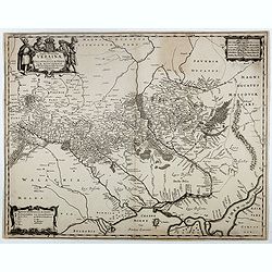
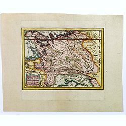
![.[Georgia (Republic), Sarmatia, Ukraine]](/uploads/cache/33870-250x250.jpg)
.[Georgia (Republic), Sarmatia, Ukraine]
Wood block printed map and one of earliest printed representation of Georgia (Republic), Sarmatia, Ukraine prepared by Martin Waldseemüller. Based on the slightly larger...
Place & Date: Vienna, Trechsel, G., 1525 -1541
![[Europe, Eastern, Sarmatia, Ukraine]](/uploads/cache/33854-250x250.jpg)
[Europe, Eastern, Sarmatia, Ukraine]
Wood block printed map and one of earliest printed representation of Europe, Eastern, Sarmatia, Ukraine prepared L. Fries after Martin Waldseemüller.Based on the slightl...
Place & Date: Vienna, Trechsel, G., 1525 -1541
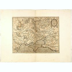
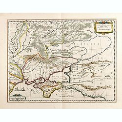
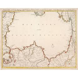
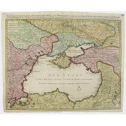
Tabula Asiae II (Black Sea and Caspian Sea)
The first edition of Munster's map of Ukraine and the region north of the Black Sea, based upon Claudius Ptolemy which appeared in his "Geographia Universalis",...
- $500 / ≈ €440
Place & Date: Basel, Heinrich Petri, 1545
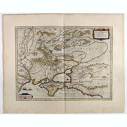
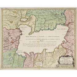
Tabula Asiae II (Black Sea and Caspian Sea).
The first edition of Münster's map of Ukraine and the region north of the Black Sea, based upon Claudius Ptolemy which appeared in his "Geographia Universalis"...
- $400 / ≈ €352
Place & Date: Basel, Heinrich Petri, 1545
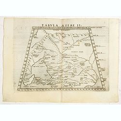
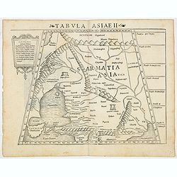
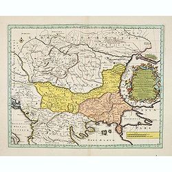
Tabula Asiae II.
Scarce FIRST edition of this map of the ancient region of Asiatic Sarmatia - now Southern Russia and part of Ukraine, around the Azov seaGirolamo Ruscelli's edition of Pt...
- $300 / ≈ €264
Place & Date: Venice, 1561
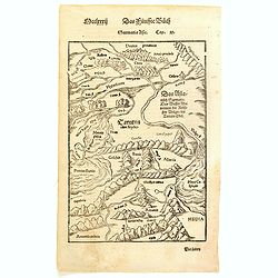
Sarmatia Asie.
The map is showing the area of Armenia and Kazakhstan. From his Cosmographia, that great compendium of Renaissance knowledge. Sebastian Münster was born in Nierder-Ingel...
- $90 / ≈ €79
Place & Date: Basle, 1550-1580
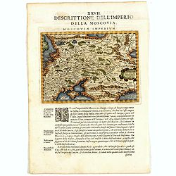
Descrittione Dell'Imperio della MOSCOVIA IMPERIUM.
Uncommon map including Latvia, Livonia, Lithuania, the Ukraine, and northern Part of the Black Sea and the Caspian Sea, Siberia, Georgia, Azerbaijan, Kazakhstan.Giovanni ...
Place & Date: Venice, 1596
Tabula Asiae II.
A striking example of Magini's map of the Black Sea region from the 1597 edition of Magini's 'Geographia', based upon the work of Claudius Ptolemy. Latin text and tables ...
- $300 / ≈ €264
Place & Date: Venice, 1597
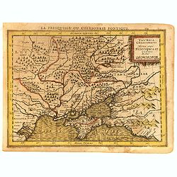
Taurica Chersonesus, Nostra aetate Prezecopsca, et Gazara dicitur.
Early and detailed map of the Ukraine, Russia with in the north Smolensk and Moscow and in the south the Black Sea. Shows ports, fortified cities and the mouths of the Da...
- $300 / ≈ €264
Place & Date: Amsterdam, ca. 1625
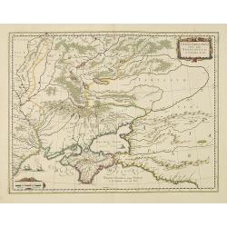
Taurica Chersonesus . . .
An attractive, detailed and early map of the Ukraine, Russia and surrounding regions between the northern coast of the Black Sea and Moscow.Shows ports, fortified cities ...
- $300 / ≈ €264
Place & Date: Amsterdam, 1630
Taurica Chersonesus, Nostra aetate Przecopsca, et Gazara dicitur.
Part of Russia with in the north Smolensk and Moscow and in the south the Black Sea.As Willem Blaeu died in 1638 most of his maps are actually published by his son Joan. ...
Place & Date: Amsterdam, 1638
Taurica Chersonesus, Nostra aetate Przecopsca, et Gazara dicitur.
Part of Russia with in the north Smolensk and Moscow and in the south the Black Sea. More about Willem Blaeu. [+]
- $300 / ≈ €264
Place & Date: Amsterdam, 1644
Taurica Chersonesus.
One of the earliest detailed maps of the Crimea and Ukraine between the northern coast of the Black Sea and Moscow.With the engraved signature of Gerard Mercator in lower...
- $300 / ≈ €264
Place & Date: Amsterdam, 1639-1644
Taurica Chersonesus, Nostra aetate Przecopsca, et Gazara dicitur.
Detailed map of the Ukraine, Russia with in the north Smolensk and Moscow and in the south the Black Sea. Shows ports, fortified cities and the mouths of the Danube. Mino...
- $750 / ≈ €661
Place & Date: Amsterdam, 1645
Taurica Chersonesus, Nostra aetate Prezecopsca, et Gazara dicitur.
Part of Russia with in the north Smolensk and including Moscow and in the south the Black Sea.More about Willem Blaeu. [+]Taurica, Tauric Chersonese, and Taurida were nam...
- $500 / ≈ €440
Place & Date: Amsterdam, 1645
Sarmatia utraque europaea et asiatica. . .
Ancient map of the European part of Russia with the Ukraine. Dated 1654.Nicolas Sanson was to bring about the rise of French cartography, although the fierce competition ...
- $200 / ≈ €176
Place & Date: Paris, 1654
Sarmatia utraque europaea et asiatica. . .
Ancient map of the European part of Russia with the Ukraine. Dated 1654.Nicolas Sanson was to bring about the rise of French cartography, although the fierce competition ...
- $300 / ≈ €264
Place & Date: Paris, 1654
Germano-Sarmatia in qua Populi maiores Venedi et Aetiaei Peucini et Bastarnae in minores Populos divisi ad hodiernam locorum et Regionum
Fine map of ancient Poland and the whole of Eastern Europe, showing part of the Baltic and Gulf of Riga, including the modern countries of Poland, Lithuania, Ukraine and ...
Place & Date: Paris, 1655
Selling price: $425
Sold in 2013
Typus Generalis Ukrainae sive Palatinatuum Podoliae, Kioviensis et Braczlaviensis terras nova delineatione exhibens. . .
A key map engraved by Johannes Janssonius in about 1656 and based on Guillaume La Vasseur de Beauplan's map of the region published in "Description d'Ukraine". ...
- $2000 / ≈ €1762
Place & Date: Amsterdam, ca. 1657
Vera Delineatio Provinciae Fertilissimae Kilan olim Hyrcaniae ad Mare Caspium Sitae.
Uncommon map prepared by Adam Olearius showing the region of Azerbaijan and Iran. The map is oriented with north to the upper left corner and adorned with an attractive t...
- $400 / ≈ €352
Place & Date: Jean Dupuis in Paris, 1659
Illyricum Orientis In quo Partes II. Moesia et Thracia. Provinciae XI.
Attractive historical map of the area west of the Black Sea, today's Bulgaria, Rumania, etc. Based on the cartography of Nicolas Sanson and published by P.Mariette. With ...
- $400 / ≈ €352
Place & Date: Paris, 1666
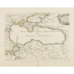
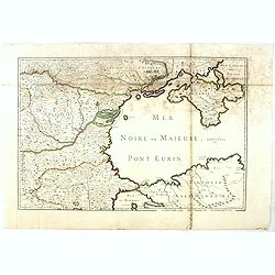
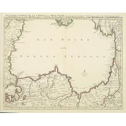
Mer Noire ou Mer Maievre, . . .
Map of the Black Sea prepared by N.Sanson and published by Pierre Mariette.Published in an early edition of the small Sanson atlas L'Europe Dediée a Monseigneur . . . Le...
Place & Date: Paris, P. Mariette, 1667
French composite atlas made up of rare maps published by Parisian editors from the 17th century , mainly by G. Jollain including scarce maps of America.
A rare French composite atlas including 90 maps, published by Parisian publishers from the 17th century, mainly by Gérard I Jollain, or by maps bought from Dutch publish...
Place & Date: Paris, ca. 1675
Stati della Corona di Polonia Divisa nella sue Principali Provincie e Palatinati da Guglielmo Sansone. . .
Rare map of Poland, Lithuania and the Ukraine. Copies of his first edition of 'Mercurio Geografico', published in 1674, do not contain a map of Poland. Only added in late...
- $1250 / ≈ €1101
Place & Date: Rome, 1678
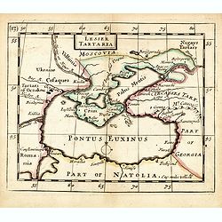
Lesser Tartaria.
A late seventeenth-century English map of the Crimea and southern Ukraine, with the whole of the Black Sea and its shores. A scarce little map utilized in various of the ...
- $300 / ≈ €264
Place & Date: London, 1685
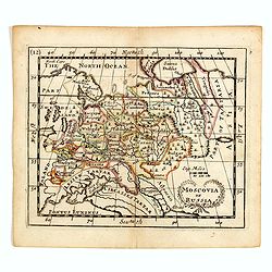
Moscovia or Russia
A rare late seventeenth-century English map of Russia and the Crimea and southern Ukraine, with the northern coast of the Black Sea and its shores. A scarce little map ut...
- $300 / ≈ €264
Place & Date: London, 1685
A unique composite atlas with updated Porro maps.
Unique composite atlas containing in total 84 maps - 82 maps engraved by Girolamo Porro and heavenly reworked around 1686 and 2 newly engraved maps; Piccola Tartaria (Cr...
Place & Date: Venice, 1686
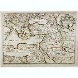
L'Empire des Turcs en Europe, en Asie et en Afrique.
A nice map showing the Turkish Empire, including an inset map of kingdom of Alger. Extending from Italy and the Eastern Mediterranean in the west to the Caspian Sea and P...
- $550 / ≈ €485
Place & Date: Paris, 1686
La Bulgaria ela Romania con Parte di Marcedonia. . .
Scarce map of the region along the Danube River and to the south. Extends to include part of the Sea of Azov and the northern extreme of the Aegean Sea. Elaborate militar...
- $600 / ≈ €529
Place & Date: Rome, 1689
Le Royaume de Hongrie.
Fine oversized map of Hungary, but including Bosnia and Herzegovina, Bulgaria, Croatia, Romania, Albania, European part of Turkey, and Ukraine. With a decorative title an...
Place & Date: Amsterdam, 1692
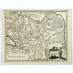
Scythia et Tartaria Asiatica.
A decorative and interesting eighteenth century map of Tartary and Scythia from an atlas first published in Leiden in 1624. Philipp Clüverius (1580–1623) was virtually...
- $125 / ≈ €110
Place & Date: Leiden, 1697
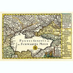
(Mer Noire ou Maieure, Pont Euxin.)
Very rare and detailed map of the Black Sea area prepared by Placide de Sainte-Hélène (1648-1734). and engraved by Claude-Auguste Berey (1651-1732).The map is of partic...
- $350 / ≈ €308
Place & Date: Paris, 1703
Estats du Grand Duc de Moscovie.
Lovely small map of' Russia in Europe', extending from Poland and the Baltic in the west, Zembla in the frozen north, reaching down south to the Ukraine with Kiev and par...
- $150 / ≈ €132
Place & Date: Paris, 1705
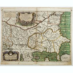
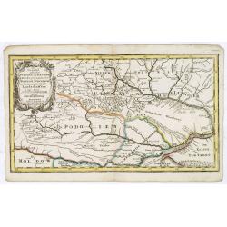
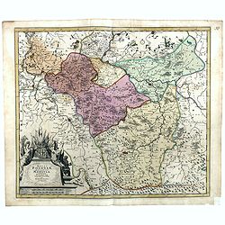
LA RUSSIE ROUGE ou POLONOISE qui Comprend les PROVINCES DE LA RUSSIE ROUGE de VOLHYNIE et de PODOLIE divisées en leurs Palatinats Vulgairement Connües sous le Nom D'VKRAINE ou PAYS DES COSAQUES.
A very rare Sanson map of Ukraine and so-called Russie Rouge, stretching from Lublin in the west to Kherson Oblast in the east (here called "Confin de La Petite Tart...
Place & Date: Paris, 1706
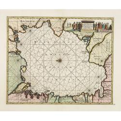
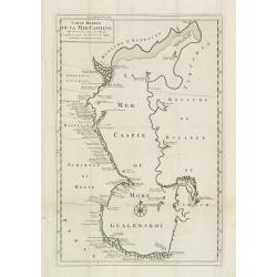
Carte marine de la mer Caspienne avec toutes ses Bayes Rivieres et Havres, dressée sur les observations des plus habiles Navigateurs,. . .
Strikingly engraved and attractive map of the Caspian Sea, showing major towns, ports, etc. Large decorative cartouche and compass rose.
- $500 / ≈ €440
Place & Date: Leiden, 1710
Assoph, Asow, oder Azak mit der Kleinen Tartarey dem Scwharzen Meer. . .
Scarce map showing the Black Sea region with Southern Ukraine, Georgia and Armenia.
- $100 / ≈ €88
Place & Date: Augsburg, 1715
Assoph, Asow, oder Azak mit der Kleinen Tartarey dem Scwharzen Meer. . .
Scarce map showing the Black Sea region with Southern Ukraine, Georgia and Armenia.
- $300 / ≈ €264
Place & Date: Augsburg, 1715
Die Gegend Zwischen Pultava und Bender Mitt Angraenzenden Polnisch, Turckisch und Tartarischen Landschafften.
Scarce map showing central part of the Ukraine with Bjelaja-Zerkow, Poltawa between the Dniester and Dnieper rivers. Black Sea in lower right corner. Detailed with notes,...
- $300 / ≈ €264
Place & Date: Augsburg, 1715
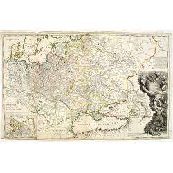
To His Most Serene and August Majesty Peter Alexovitz Absolute Lord of Russia &c. This map of Moscovy, Poland, Little Tartary, and ye Black Sea &c. is most Humbly Dedicated by H. Moll Geographer
Magnificent large-scale, English map of Russia, Ukraine, Poland, Finland and the Baltic Countries and extending south to the Black Sea and the Balkans, with an ornate ded...
- $1500 / ≈ €1321
Place & Date: London, 1716
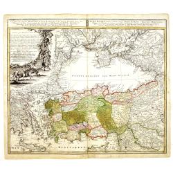
Seconde partie de la Crimee la Mer Noire. . .
The lower part of a set of two maps from the observations of Guillaume Delisle focusing on the Black Sea with wonderful detail of the surrounding regions. Includes Consta...
- $750 / ≈ €661
Place & Date: Amsterdam, 1720
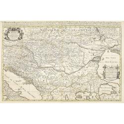
Tabula Geographica qua pars Russiae Magnae. . .
Homann's map is based upon Beauplan's general map of Ukraine but depicts the political changes of the preceding years. With decorative cartouches. Giving good detail alon...
- $680 / ≈ €599
Place & Date: Nuremberg, 1720
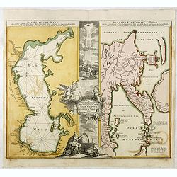
Das Caspische Meer / Das Land Kamtzadalie ...
Two maps on one sheet with the Caspian Sea on one side and northeastern Russia and Kamchatka on the other. The map of the Caspian Sea reflects the survey work of Russia�...
- $450 / ≈ €396
Place & Date: Nuremberg, 1720
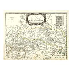
Maris Assoviensis vel de Zabache et Paludis Maeotidis. . .
A very detailed map showing the Black Sea, Azow and Rostow area.
Place & Date: Augsburg, 1720
Partie Meridionale de Moscovie. . .
Centered on Moscow including Azow and part of present-day Ukraine in the bottom part of the map. The map is based on Delisle's important map of the region with revisions ...
- $200 / ≈ €176
Place & Date: Amsterdam, 1720
Seconde partie de la Crimee la Mer Noire. . .
The lower part of a set of two maps from the observations of Guillaume Delisle focuses on the Black Sea with wonderful detail of the surrounding regions. Includes Constan...
- $500 / ≈ €440
Place & Date: Amsterdam, 1720
Nova ac verissima Maris Caspii ante hac maximam fere partem nobis incogniti, ac Regionum adiacentium : Delineatio Iussu Invictissimi Principis Petri Alexii Fil. Magni Russorum Imperatoris / immenso labore et maximis sumptibus facta, atque ex ...
Covers portions of Iran, Turkmenistan, Kazakhstan, Russia and Azerbaijan. Relief is shown pictorially. Depth is shown by soundings. Oriented with north to the left. Rare.
- $750 / ≈ €661
Place & Date: Amsterdam, 1720
Illyricum Orientis In quo Partes II. Moesia et Thracia. Provinciae XI.
Attractive historical map of the area west of the Black Sea, today's Bulgaria, Rumania, etc. Based on the cartography of Nicolas Sanson and published by Covens and Mortie...
- $400 / ≈ €352
Place & Date: Amsterdam, c. 1720
Asia intra Maeotim Pontum et Mare Caspium. . .
Striking map the Black Sea and Caspian Sea regions, featuring the geographical features known to the ancients and decorated with a vignette and 10 medallions.From "D...
- $195 / ≈ €172
Place & Date: Nuremberg, 1720
Partie Meridionale de Moscovie. . .
Scarce map centered on Moscow including Azow and part of present-day Ukraine in the bottom part of the map. The map is based on Delisle's important map of the region with...
- $750 / ≈ €661
Place & Date: Amsterdam, 1720
Maris Assoviensis vel de Zabache et Paludis Maeotidis. . .
A very detailed map showing the Black Sea, Azow and Rostow area. With a decorative allegorical cartouche, showing the costumes of the indigenous people of the region.
- $900 / ≈ €793
Place & Date: Augsburg, 1720
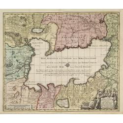
Tabula geographica Russiae Magnae pontus euxinus seu mare nigrum et tauriae regnum. . .
Decorative map of the Black Sea Region, with a large decorative cartouche. Shows Constantinople. Extends north to Moscow and Smolensko.
- $750 / ≈ €661
Place & Date: Nuremberg, 1720
Carte des Pays Voisins de la Mer Caspiene dressee pour l' usage du Roy. . .
The map shows the area east of the Caspian Sea, including parts of Kazakhstan, Turkmenistan, Uzbekistan, and northern Iran. The area eastward from the Caspian is marked '...
- $750 / ≈ €661
Place & Date: Paris, 1723
Regni Poloniae, ducatus Mazoviae et province Cujaviae / descriptio emendata per R. & I. Ottens
Very rare map of Poland Lithuania and Ukraine, etc. Engraved by A. Schut.Joachim Ottens (1663 - 1719) and his sons Renier and Joshua were prominent Dutch booksellers and ...
Place & Date: Amsterdam, 1725
Selling price: $1500
Sold in 2017
Carte Marine De La Mer Caspiene levée suivant les ordres de S.M.Cz. En 1719, 1720 et 1721.
Detailed of the Caspian Sea, prepared by Karl van Verden in 1722. Van Verden was a Russian sailor and the Czar's Special Commander, who produced the first accurate map of...
Place & Date: Paris, ca. 1725
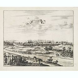
Moruma ville de la Tartarie Moscovite.
Decorative view of the town of Moruma, Russian city near the northern shore of the Caspian sea as seen from across the river Oka. This well executed engraving was publish...
- $300 / ≈ €264
Place & Date: Leiden, 1719-1727
Nova Mappa Geographica Maris Assoviensis Vel De Zabache Et Paludis Maeotidis accurate aeri incis et in luce edita . . .
Striking map of the Sea of Azov with adjacent countries and the Strait of Kerch, with a decorative allegorical cartouche, showing the costumes of the indigenous people of...
- $400 / ≈ €352
Place & Date: Augsburg, 1730
Imperii Moscovitici pars Australis.
A detailed map of the region around Moscow. Including the Ukraine and Cossack regions, to the west is Russian Poland and Lithuania, to the east Russian Tartary and Siberi...
- $500 / ≈ €440
Place & Date: Augsburg, 1730
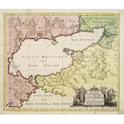
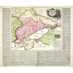
Nouvelle Carte de la Petite Tartarie et la Mer Noire, montrant les Frontieres de l'Impératrice de Russie et de l'Empereur des Turcs, tant en Europe qu'en Asie, Dessigné selon la proposition de G. De L'Isle et d'autres Auteurs.
The Ukraine and the Black Sea in a fine impression with original 18th-c. hand-coloring.
- $1250 / ≈ €1101
Place & Date: Amsterdam, 1730
Geographica Nova ex Oriente gratiosissima, duabus tabulis specialissimis contenta, quarum una Mare Caspium..
Map of the Caspian Sea and the peninsula of Kamchatka (Jedso) in northeast Asia on one sheet.Separated by an attractive panel with figurative title cartouche, cherubs, an...
Place & Date: Nuremberg, 1730
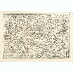
Nieuwe kaart van Muskovien door M. de l'Isle.
This lovely little map of the area surrounding Moscow is based on Delisle's map of the region. The map is bounded by Lake Ilmen in the north, the Volga River to the east,...
- $100 / ≈ €88
Place & Date: Amsterdam, 1735
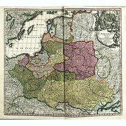
Poloniae Regnum ut et Magni Ducatus Lithuaniae . . .
Detailed map of Poland and the Baltic regions, extending in the south to Ukraine and northern Hungary.Here in its second state, now with added letters to the border scale...
- $750 / ≈ €661
Place & Date: Augsburg, 1735
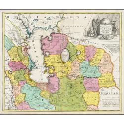
Nova Maris Caspii et Regionis Usbeck cum Provincijs adjacentibus vera Delineatio
This is the first printed map specifically of the Uzbek region. The map shows the area around the Caspian Sea and northern Iran. The earea eastwards from the Caspian is m...
Place & Date: Nuremberg, 1735
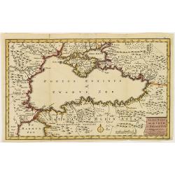
Nieuwe kaart van de Crim de Zwarte Zee en omleggende. . .
Showing the Black Sea and the Marmara Sea with Istanbul. Published in the rare first edition of Kleyne en Beknopte Atlas, of Tooneel des Oorlogs in Europa...The atlas wa...
Place & Date: Amsterdam, 1735
Selling price: $450
Sold in 2013
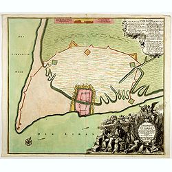
Ichnographia munitissimae Arcis Otzakoff quae Ao. 1737, die 3 Iulÿ auspicÿs Supremi Campi Mareschalli Comitis de Münnich ab exercitu Russorum vi occupata . . .
A striking image of this fortified Russian outpost on the Black Sea at Otzakoff, northeast of Odessa.
- $1100 / ≈ €969
Place & Date: Augsburg, 1737
An exact map of the CRIM (Formely Taurica Chersonesus) Part of Lesser Tartary, the Sea of Asoph, and the adjacent Country of the Kuban Tartars. . .
Detailed and handsome wood block printed map centered on the Sea of Azov detailing the ongoing war between the Russians and Turks. The map is filled troop locations and b...
Place & Date: London, 1739
Selling price: $200
Sold in 2010
Nova et accuratissima Maris Caspii. . .
Original hand colored copper engraving of Matthaeus Seutter. Showing the Caspian Sea with the large Volga Delta in east orientation. Main towns / countries around the Cas...
- $750 / ≈ €661
Place & Date: Augsburg, 1740
Moscoviae seu Russiae Magnae Generalis Tabula. . .
A scarce and attractive, wide-ranging map of incorporating Scandinavia, the Baltic countries, parts of Germany and Czechoslovakia, Poland, Hungary, Ukraine, Bulgaria, Nor...
- $1500 / ≈ €1321
Place & Date: Augsburg, 1740
Verus Chersonesi Tauricae Seu Crimea Conspectus adjacentium item Regionem itinerisq ab Exercitu Ruthemo Ao MDCCXXXVI et MDCCXXXVII adversus Tattaros Susceptis . . .
Map of the environs of the Crimea, showing the route of the Russian Army in its expedition against the Tartars in 1736 and 1737. Showing detailed movements, including enc...
Place & Date: St Petersburg, Academy of Sciences, 1740
Selling price: $700
Sold in 2015
Die Europaeische oder kleine Tartarey, nebst den angraentzenden Laendern. . .
Showing the Black Sea region. Uncommon map from the "Atlas Selectus" by the German cartographer Johann Georg Schreiber (1676-1750). Schreiber followed in the fo...
- $450 / ≈ €396
Place & Date: Leipzig, 1741
![[2 maps and one text sheet] Theatrum Belli A° MDCCXXXVII. . . / Verus Chersonesi Tauricae Seu Crimea Conspectus adjacentium item Regionem itinerisq ab Exercitu Ruthemo...](/uploads/cache/27975-250x250.jpg)
[2 maps and one text sheet] Theatrum Belli A° MDCCXXXVII. . . / Verus Chersonesi Tauricae Seu Crimea Conspectus adjacentium item Regionem itinerisq ab Exercitu Ruthemo...
[2 maps and one text sheet] Theatrum Belli A° MDCCXXXVII. . . / Verus Chersonesi Tauricae Seu Crimea Conspectus adjacentium item Regionem itinerisq ab Exercitu Ruthemo A...
- $1100 / ≈ €969
Place & Date: Amsterdam, c. 1744
Carte de L'Asie Mineure ou de la Natolie et du Pont Euxin
Johann Baptist Homann's well-engraved map of Asia Minor, the Black Sea ( Ponti Euxin), Crimea and a part of Greece. Depicts Turkey and the area surrounding the Black Sea ...
- $500 / ≈ €440
Place & Date: Nuremberg, ca. 1748
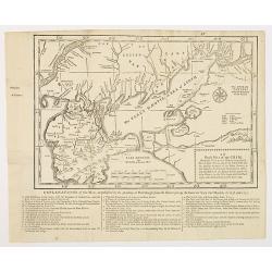
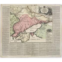
Charte der Kriegs Operationen am Donn u: Dnieper Ihro Russisch Kayserl Majestaet Glorieusen Armeen A: 1736.
Very rare separately published map of the southern part of Ukraine, with an explanatory key A-N in the lower right. The map is surrounded by letterpress German text givin...
- $900 / ≈ €793
Place & Date: Augsburg, 1750
Charte der Kriegs Operationen am Donn u: Dnieper Ihro Russisch Kayserl Majestaet Glorieusen Armeen A: 1736
Scarce separately published map of the southern part of Ukraine, with an explanatory key A-N in the lower right. The map is surrounded by letterpress German text giving a...
Place & Date: Augsburg, 1750
Selling price: $900
Sold in 2011
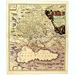
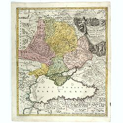
Tabula Geographica qua pars Russiae Magnae Pontus Euxinus seu Mare Nigrum et Tartaria Minor.
Homann's map is based upon the works of George von Mengden (1628-1702) a Livonian cartographer who worked for Peter the Great and Count Jacob Bruce [Graf Jakov Villimovic...
- $750 / ≈ €661
Place & Date: Nuremburg, after 1750
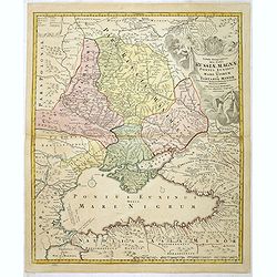
Tabula Geographica qua pars Russiae Magnae. . .
Homann's map is based upon the works of George von Mengden (1628-1702), a Livonian cartographer who worked for Peter the Great and Count Jacob Bruce [Graf Jakov Villimovi...
- $600 / ≈ €529
Place & Date: Nuremburg, after 1750
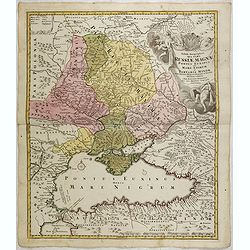
Tabula Geographica qua pars Russiae Magnae Pontus Euxinus seu mare Nigrum et Tartaria Minor cum finitimis Bulgariae, et Romaniae et Natoliae. . .
Homann's map is based upon Beauplan's general map of Ukraine but depicts the political changes of the preceding years. Shows Constantinople. Extends north to Moscow and S...
- $700 / ≈ €617
Place & Date: Nuremburg, 1750
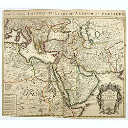
Carte de la Turquie de L'Arabie et de la Perse.
This is the Amsterdam issue of De L'Isle's map of the Turkish Empire and Arabian Peninsula. It includes the Turkish Empire, the Mediterranean, Central Asia, and parts of ...
Place & Date: Amsterdam, 1751