Search Listings matching "renneville"
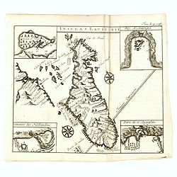
Insula S. Laurentii.
Miniature map of Madagascar, with four inset maps. From the French reissue of the account of early Dutch voyages first published in 1608 by Commelin. The French translati...
- $150 / ≈ €140
Place & Date: Amsterdam, E. Roger, 1702

(Map of Nova Zembla with inset of Baye de Loms.)
Map of Nova Zembla with inset of Baye de Loms (5x7mm.). From the French reissue of the account of early Dutch voyages first published in 1608 by Commelin. The French tran...
- $110 / ≈ €103
Place & Date: Amsterdam, E. Roger, 1702

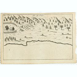
Anabon. (Ambon)
A fanciful view of a landscape on the island Ambon.From the French reissue of the account of early Dutch voyages first published in 1608 by Commelin. The French translati...
- $120 / ≈ €112
Place & Date: Amsterdam, E. Rogers, 1703

La Baye de l'Isle & ville de Borneo.
Uncommon map of a Bay on the island of Borneo. From the French reissue of the account of early Dutch voyages first published in 1608 by Commelin. The French translation w...
- $100 / ≈ €94
Place & Date: Amsterdam, E. Roger, 1703

Solor / A la Baye de Solor.
Decorative map of the Bay of Solor. With a lettered key (A - E). Solor is a volcanic island located off the eastern tip of Flores island in the Lesser Sunda Islands of In...
- $120 / ≈ €112
Place & Date: Amsterdam, E. Rogers, 1703
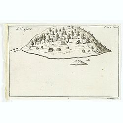
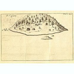
I. S. Clara.
Island "S. Clara" in Brazil just a few degrees north of the Tropic of Capricorn.From volume two of the French reissue of the account of early Dutch voyages. The...
- $150 / ≈ €140
Place & Date: Amsterdam, E. Roger, 1703
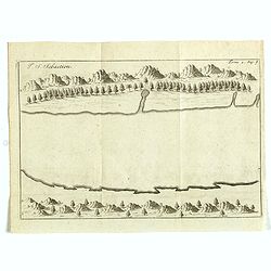
I. S. Sebastien.
Simplified bird's-eye view of Ilha de São Sebastiao, part of an archipelago off the southern coast of Brazil 210 miles from Rio de Janeiro. It was discovered on January ...
- $225 / ≈ €211
Place & Date: Amsterdam, E. Roger, 1703

Batavia, L'an 1629.
Scarce town-view of Batavia (Jakarta) in 1629.From the French reissue of the account of early Dutch voyages first published in 1608 by Commelin. The French translation wa...
- $150 / ≈ €140
Place & Date: Amsterdam, 1725

(Bird's eye view of the Bay of Bantam)
Early view of the Bay of Bantam with the islands of Pulo dua and Batto.Bantam was always a product of the ferocious commercial rivalry between the Dutch and English and P...
- $75 / ≈ €70
Place & Date: Amsterdam, F. Bernard, 1725
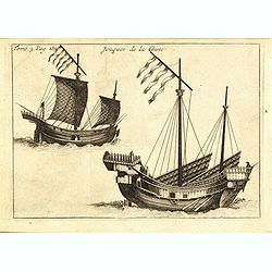
Jonques de la Chine.
A depiction of two Chinese junks. Tome 3 Page 377. From the French reissue of the account of early Dutch voyages first published in 1608 by Commelin. The French translati...
- $75 / ≈ €70
Place & Date: Amsterdam, J.F. Bernard, 1725

Idolle des Chinois.
Print of a Chinese divinity. Tome 3 Page 377 in upper left corner. From the French reissue of the account of early Dutch voyages first published in 1608 by Commelin. The ...
- $75 / ≈ €70
Place & Date: Amsterdam, J.F. Bernard, 1725
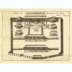
Palais de Lamthau à la Chine.
View of a Mandarin's Palace at Lantau Island, showing the palace wall, 3 gates and guards in the inner palace where the Mandarin meets with the officers.. Tome 3 Page 392...
- $75 / ≈ €70
Place & Date: Amsterdam, J.F. Bernard, 1725

La ville et le fort de Gamma-Lamma dans l'isle de Ternate lequel fort apartient aux Espagnols.
A view of the town and fortress on the island of Ternate. The city was in the southern part of the island, in the place now called Kastela. From the French reissue of the...
- $100 / ≈ €94
Place & Date: Amsterdam, J.F. Bernard, 1725
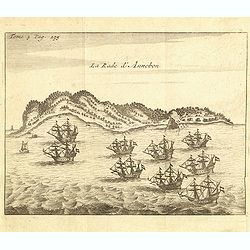
La rade d'Annobon.
Fine print of the arrival of the Dutch fleet by Cornelis Matelief de Jonge at Annobon, September 7th 1605. Cornelis Matelief de Jonge made a trip for the V.O.C. to the Ea...
- $100 / ≈ €94
Place & Date: Amsterdam, J.F. Bernard, 1725

Le fort d'Amboine tel qu'il était en l'an 1607.
Fine depiction of the Dutch fortress on Ambon Island which is part of the Maluku Islands of Indonesia. The island has an area of 775 km2 (299 sq mi).From the French reiss...
- $80 / ≈ €75
Place & Date: Amsterdam, J.F. Bernard, 1725

Le fort d'Amboine tel qu'il était en l'an 1607.
Fine plan of the Dutch fortress on Ambon Island which is part of the Maluku Islands of Indonesia. The island has an area of 775 km2 (299 sq mi).From the French reissue of...
- $75 / ≈ €70
Place & Date: Amsterdam, J.F. Bernard, 1725

Malacca.
Fine print showing Dutch vessels offshore the city of Malacca and it is located 2 degrees north of the equator by the shore of the Straits of Malacca between Singapore to...
- $175 / ≈ €164
Place & Date: Amsterdam, J.F. Bernard, 1725

Ternate, par son aspect oriental.
This map is a view of Ternate with the summit of Gamalama from Dodoku Ali. From the French reissue of the account of early Dutch voyages first published in 1608 by Commel...
- $75 / ≈ €70
Place & Date: Amsterdam, J.F. Bernard, 1725

Ormus. (Hormuz)
Panoramic view of the town of Hormuz, with little inset map of the island. From the French reissue of the account of early Dutch voyages first published in 1608 by Commel...
- $200 / ≈ €187
Place & Date: Amsterdam, F. Bernard, 1725
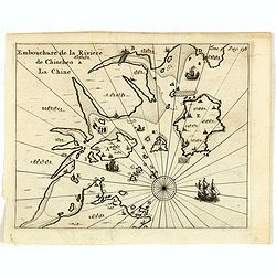
Embouchure de la rivière de Chincheo à la Chine.
This map is a view of Quanzhou Bay. Quanzhou was established in 718 during the Tang Dynasty (618–907). In those days, Guangzhou was China's greatest seaport, but this s...
Place & Date: Amsterdam, F. Bernard, 1725
Selling price: $110
Sold in 2014

Fort de l'Isle de Banda.
Decorative print of the Dutch fortress on the island Banda.From the French reissue of the account of early Dutch voyages first published in 1608 by Commelin. The French t...
- $90 / ≈ €84
Place & Date: Amsterdam, F. Bernard, 1725

(Gunanappi / Wayer / Nera / Pulorin / Puloway .)
Uncommon map of islands in the Banda Sea. Several islands and villages are named, Wayer, Nera, Pulorin, Puloway, Lontoor, Ortattan and Combeer.From the French reissue of ...
- $75 / ≈ €70
Place & Date: Amsterdam, F. Bernard, 1725
I. S. Clara.
Island "S. Clara" in Brazil just a few degrees north of the Tropic of Capricorn.From volume two of the French reissue of the account of early Dutch voyages. The...
- $100 / ≈ €94
Place & Date: Amsterdam, F. Bernard, 1725
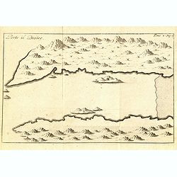
Porto il Desire.
Simplified bird's-eye view of Port Desire or Puerto Deseado in present-day Argentina.From volume two of the French reissue of the account of early Dutch voyages. The Fren...
- $150 / ≈ €140
Place & Date: Amsterdam, F. Bernard, 1725

La Baye de l'Isle & ville de Borneo.
Uncommon map of a Bay on the island of Borneo. From the French reissue of the account of early Dutch voyages first published in 1608 by Commelin. The French translation w...
- $75 / ≈ €70
Place & Date: Amsterdam, F. Bernard, 1725

(Map of Nova Zembla with inset of Baye de Loms.)
Map of Nova Zembla with inset of Baye de Loms (5x7mm.).From the French reissue of the account of early Dutch voyages first published in 1608 by Commelin. The French trans...
- $100 / ≈ €94
Place & Date: Amsterdam, F. Bernard, 1725

Solor / A la Baye de Solor.
Decorative map of the Bay of Solor. With a lettered key (A - E). Solor is a volcanic island located off the eastern tip of Flores island in the Lesser Sunda Islands of In...
- $75 / ≈ €70
Place & Date: Amsterdam, F. Bernard, 1725
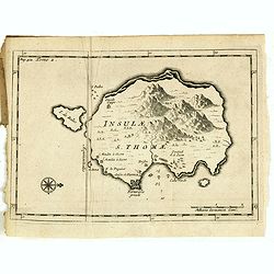
Insulae S. Thomae.
Uncommon map of the Island of St. Thomas located in the Atlantic Ocean near West Africa. From the French reissue of the account of early Dutch voyages first published in ...
- $75 / ≈ €70
Place & Date: Amsterdam, F. Bernard, 1725
Isle du Prince.
Simplified bird's-eye view of "Isle du Prince" in present-day Argentina.From volume two of the French reissue of the account of early Dutch voyages. The French ...
- $75 / ≈ €70
Place & Date: Amsterdam, F. Bernard, 1725