Search Listings matching "isle,"
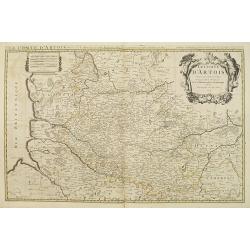
Le comte d'Artois dresse sur les memoires les plus nouveaux. . .
Map showing the north of France, showing St Omer, and Arras, etc. The map notes Nicolas Sanson as the mapmaker and claims that the map was published by Alexis-Hubert Jail...
Place & Date: Amsterdam, 1693

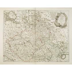
Le Duche de Pomeranie divise en ses principales parties. . .
Fine map of Pomerania with a decorative title and scale cartouche.The map notes Nicolas Sanson as the mapmaker and claims that the map was published by Alexis-Hubert Jail...
- $550 / ≈ €485
Place & Date: Amsterdam, 1693
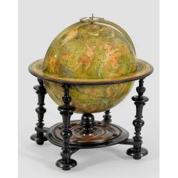
A very rare Louis XIV celestial globe by Guillaume De L'Isle, Paris, 1700, with his first address "Rue des Canettes".
Decorated with constellation figures, backgrounds in green, constellation figures hightened in red and pale colors, metal axis, brass meridian circle, graduated on one fa...
- $25000 / ≈ €22024
Place & Date: Paris, 1701
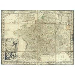
Le Royaume de France avec ses acquisitions ; Divisé en Provinces et en Gouvernemens etc. Dressé sur les Mémoires les plus Nouveaux et Dédié à Louis le Grand Roy de France et de Navarre / par son très Humble serviteur…
Impressive wall map of France decorated with a large figurative title cartouche, a dedication cartouche to the glory of the King of France Louis XIV, and plans of battles...
- $2500 / ≈ €2202
Place & Date: Paris, à présent rue St. Jacques au-dessus de la rue des Mathurins à l'enseigne de la Place des Victoires et du Lion d'Argent, c. 1715
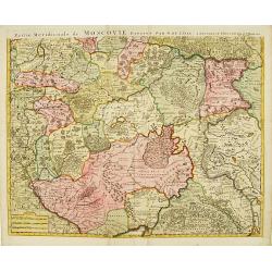
Partie Meridionale de Moscovie..
Centered on Moscow, including Azow in the bottom part of the map.The Amsterdam publishing firm of Covens and Mortier (1721 - c. 1862) was the successor to the extensive p...
- $300 / ≈ €264
Place & Date: Amsterdam 1720
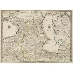
Carte des Pays Voisins de la Mer Caspiene dressee pour l' usage du Roy. . .
The map shows the area east of the Caspian Sea, including parts of Kazakhstan, Turkmenistan, Uzbekistan, and northern Iran. The area eastward from the Caspian is marked '...
- $750 / ≈ €661
Place & Date: Paris, 1723

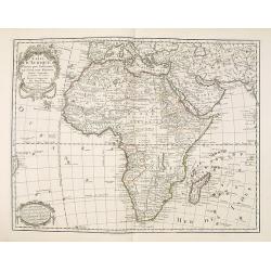
Carte du Congo et du Pays des Cafres. . .
Detailed copper-engraved map of southern Africa providing numerous particulars and comments concerning European trade, native kingdoms, and mineral wealth. Includes Madag...
Place & Date: Amsterdam, c. 1730
![(Chatelain "Atlas Historique" in 7 volumes.]](/uploads/cache/47053X-250x250.jpg)
(Chatelain "Atlas Historique" in 7 volumes.]
Henri Abraham Chatelain, whose Atlas Historique was one of the most expansive encyclopedias of the age. First published in 1705, Chatelain's Atlas Historique was part o...
Place & Date: Amsterdam: Chez Zacharie Châtelain, 1732 - 1739
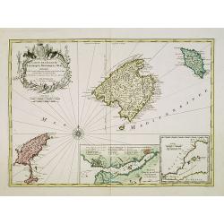
Carte des Isles de Maiorque Minorque et Yvice dediée A.M. le Comte de Maurepas Ministre et secretaire d'Etat. . .
Fine map of the Baleares with much detail, in lower part inset "Plan du Port de Mahon du Fort St. Philippe et ses Fortifications". The map is dedicated to Jean ...
Place & Date: Amsterdam, after 1740

Regionum Italiae mediarum Tabula Geographica. . .
Fine historical map of central Italy with Tuscany, centered on Rome, in the south Pompeii, in the top the island of Giglio and the town Orbetello. Lower left inset plan o...
- $150 / ≈ €132
Place & Date: Paris, 1745

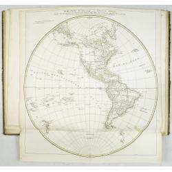
L'Amerique Meridionale Dressée sur les Observations..
Detailed map of South America prepared by De L'Isle, with fine title cartouche.The map is from a Dutch edition of De L'Isle's work entitled, Atlas Nouveau, Contenant Tout...
- $500 / ≈ €440
Place & Date: Amsterdam c. 1745

L'Amerique Meridionale Dressée sur les Observations . . .
Detailed map of South America prepared by De L'Isle, with fine title cartouche.
- $500 / ≈ €440
Place & Date: Amsterdam, ca. 1745
![ATLAS RUSSICUS mappa una generali et undeviginti specialibus vastissimum Imperium Russicum cum adiacentibus regionibus [repeated in French].](/uploads/cache/27877-250x250.jpg)
ATLAS RUSSICUS mappa una generali et undeviginti specialibus vastissimum Imperium Russicum cum adiacentibus regionibus [repeated in French].
After an unnumbered general map of Russia there are 13 numbered maps that cover European Russia (scale 1, 1.527.000). The other (last) 6 maps cover Asian Russia (Siberia,...
Place & Date: St Peterburg, Akademie von Wissenschaften. 1745

No title (Carte générale de l'empire de Russie).
The right hand sheet of a map of the Empire of Peter the Great.This important map is based on maps from the Bering expedition and on De L'Isle's Akademiia nauk Atlas of 1...
- $800 / ≈ €705
Place & Date: Amsterdam, ca.1748

L'amerique meridionale dressee sur les memoires le plus recens. . .
Rare and decorative map of South America with good detail and interesting notations concerning the explorations of the interior. With in the lower right corner a title ca...
- $550 / ≈ €485
Place & Date: Amsterdam, 1757
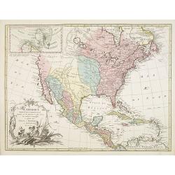
L'Amerique septentrionale, Dressée sur les memoires les plus recens. . . MDCCLVII
A rare map of North America, showing good detail, especially in the region between the Appalachians and the Mississippi and the course o the Mississippi to its source, wh...
- $1500 / ≈ €1321
Place & Date: Amsterdam, 1757
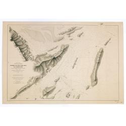
![[manuscript plan] Siège de Schweidnitz en Silésie fait par les trouppes Imperial es commandées par Mr. le de Nadasti ...](/uploads/cache/39893-250x250.jpg)
[manuscript plan] Siège de Schweidnitz en Silésie fait par les trouppes Imperial es commandées par Mr. le de Nadasti ...
This fine manuscript shows the layout of the city of Swidnica with its surrounding defence wall, its advanced bastions and suburbs, roads and two nearby villages. In lowe...
- $2750 / ≈ €2423
Place & Date: France, 1769
Carte D'Afrique Dressée pour l'usage du Roy. Par Guillaume Delisle, Premier Géographe de Sa Majesté, de l'Académie Royale des Sciences…
Curious late issue of De L'Isle's map of the African continent from 1722 map "Corrigée et Augmentée en 1781". - The decorative map shows the continent Africa ...
- $1250 / ≈ €1101
Place & Date: Paris, 1781
Atlas in elephant folio.
Most of D'Anville's atlases were made up for the individual customer, so no two appear alike. Many of the 59 pages are multi-sheet maps, so the actual map sheet count is ...
Place & Date: Paris, 1771-1786

L'Allemagne dressée sur les observations. . .
Map of Germany, Low Countries, Poland, Switzerland, Northern Italy. Prepared by G.De L'Isle after observations by Kepler and Tycho Brahe.Engraved by Jean Batiste Liébaux...
- $300 / ≈ €264
Place & Date: Paris, 1788
Le Royaume de Boheme, le Duché de Silesie, et les Marquisats de Moravie et Lusace, dresses d'apres les cartes de Muller . .
Map of Poland, Bohemia, Silesia, Moravia and Lusatia. Large decorative title cartouche in upper right. In upper left corner inset plan of Breslau and in lower right a ins...
Place & Date: Paris, 1790

Les Isles Britanniques ou sont le Rme. D'Angleterre . . . Par G. De L'Isle. . . A Paris Chez Dezauche. . .
Uncommon late edition, (dated An 8, 1800 ) of this map of the British Isles prepared by DeL'Isle and published during the French Revolution by Dezauche / Buache. The bott...
Place & Date: Paris, 1800
Carte d'Afrique Dressée pour l'instruction par Guillaume DeLisle. . .
The map is a rare re-issue of the Delisle map of 1722. In his first map of the continent in 1700, Delisle re-measured the Mediterranean, being the first to establish its ...
Place & Date: Paris, J.Dezauche, 1819
Mer de Chine. Golfe du Tonkin. Entrées de Kuaï-Chin-Mun et Tsieng-Mun. . .
Large chart centred on the Gulf of Tonkin in the South China Sea. Showing banks, isles and soundings made in metres. Relief is shown by hachures.Engraved by A. Gérin aft...
Place & Date: Paris, 1887
Selling price: $300
Sold in 2008