Search Listings matching "folding-map"
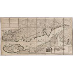
Plan de la Ville et du Port Mahon et du Fort St. Philippe..
Uncommon folding-map of the fort and town St.Philippe and port Mahon. In upper left corner a key in French (A-Z, Aa-Bb) and a key in Spanish (A-Z, Aa-Oo).A first state. A...
- $800 / ≈ €705
Place & Date: Paris, 1756
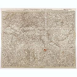
Carte topographique d'Allemagne contenant une partie du royaume de Boheme. . .
Detailed map cantered on Prague, Caaden, Laim, Melnik… Map 43 of the multi sheet map "Carte topographique d'Allemagne" of German Empire. Published by Johann W...
- $100 / ≈ €88
Place & Date: Frankfurt, ca.1780
![[Crimea]. Carte de la Cromée.](/uploads/cache/25719-250x250.jpg)
[Crimea]. Carte de la Cromée.
Mapmaker, Captain Jan Hendrik van Kinsbergen (1735-1819). Published by H. Friesman in 1787. This map first appeared in 1776 and was the first Russian map of the newly ann...
Place & Date: Amsterdam, H. Frieseman, 1787
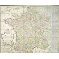
La France divisée en 83 départemens suivant les décréts de l'Assemblée Nationale, sanctionnés per le Roi. . .
An interesting folding map of France divided in 83 departments, to the right the 83 departments added on past-on slips. Another past-on is advertising Desnos' atlas in la...
Place & Date: Paris, 1790
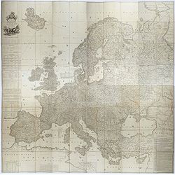
Carte de l'Europe dediée a Son Altesse royale Monseigneur Charles Louis archiduc d'Autriche, prince royal de Hongrie et de Bohéme, chevalier de la Toison d'Or, Grand-Croix de l'ordre...
Probably the largest published map of Europe during the regime of Napoleon.In upper left corner a large title cartouche with coats of arms and a dedication to Archduke Ch...
- $4000 / ≈ €3524
Place & Date: Paris, 1803
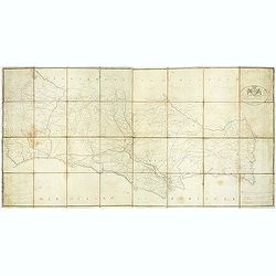
Carta militar das principaes estradas de Portugal.
Rare road map of Portugal in a scale of ca 1:470000. At the bottom right and left legends in Portuguese and French. Engraved by Romão Eloy de Almeida, who was a Portugue...
Place & Date: Lisbone, 1808
Amérique, réduite d'après celles d'Arrowsmith en 4 flles Par J.N.Champion, Ingénieur-Geographe et . . . Nouvelles découvertes de Clacke et du Major Pike . . .
A charming folding-map of America, drawn by J.N. Champion. The title explains that the map used the latest information by Alexander Humboldt and Clarck and Pike. Dated 18...
- $500 / ≈ €440
Place & Date: Paris, 1815
![[Untitled map of a part of Poland and Prussia].](/uploads/cache/25710-250x250.jpg)
[Untitled map of a part of Poland and Prussia].
Large folding map, being upper right part of a multi-sheet map, showing the northern part of Poland with good detail around Gdansk. Published by Jean Claude Dezauche (17...
- $400 / ≈ €352
Place & Date: Paris, ca. 1816-1824

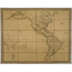
Carte de l'Amerique septentrionale Rédigée par A.H.Brué géographe.
Detailed dissected folding-map of North and Central America by Brué, originally published in Atlas Universel but here mounted on linen and intersected in 8 parts. Next t...
- $250 / ≈ €220
Place & Date: Paris, 1825
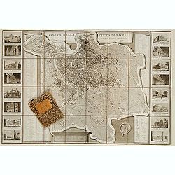
Pianta Della Citta di Roma con la Indicazione di tutte le Antichita e Nuovi Abbelliment.
Beautiful engraved town-plan of Rome with side borders depicting the 16 most important monuments and with a legend locating the major places and buildings.The views are o...
Place & Date: Venanzio Monaldini, Rome, 1829

Carte des environs de Pau. . .
Folding map of Pau and its surroundings, being a reduced version of the map by Comte Dulong de Rosnay and engraved by Nicolas Delamare and published by Lafon.More about f...
- $90 / ≈ €79
Place & Date: Pau, Lafon, 1840-1850
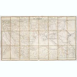
Carte pour suivre la marche de la guerre en Orient, dressée d'après les ordres de l'empereur: par L. Sagansan.
Detailed folding map of the theatre of war in the Balkans, Ukraine and around the Black Sea, indicating the Austrian, Russian and Turkish spheres of influence, prepared b...
Place & Date: Paris, ca. 1854
Selling price: $50
Sold in 2019
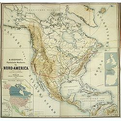
Kiepert's Physikalische Wandkarten. VI. Nord-America.
Large folding school wall map of North and Central America printed in chromo-lithography. Published by Dieter Reimer and printed by Leopold Kraatz in Berlin. Three inset...
Place & Date: Berlin, Dieter Reimer, 1864
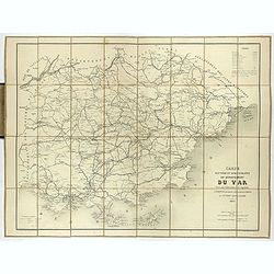
Carte routière et administrative du département du Var dressée sous l'administration et l'approbation de M. Montois, officier de la légion d'honneur, préfet , par J.B CHABET.
Folding-map of the Maritime Alps, and the Mediterranean coastline of Fréjus, Ramatuelle, St Tropez, Toulon. Engraved by Erhard, geographer and engraver (1821-1880) at th...
- $150 / ≈ €132
Place & Date: Paris, 1865
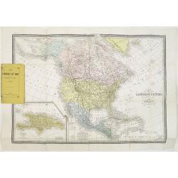
Carte de L'Amérique du Nord. . .
Detailed map of Nord America and Central America giving good detail along the east coast and the Lakes. Including San Francisco, Monterey, etc.With inset map of Dominican...
- $250 / ≈ €220
Place & Date: Paris, 1870

Carte nationale des routes de la France.
Map of the national roads in France, engraved and published by Regnier et Dourdet. Four inset maps of which three shows the three largest cities in France and one shows C...
- $300 / ≈ €264
Place & Date: Paris, ca. 1900
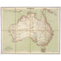
AUSTRALIE
Detailed folding maps of Australia. In upper left corner "Atlas Universal" and in upper right corner "Carte 78".In lower left "Dessiné: le trait...
Place & Date: Paris, ca. 1930

Principaux archipels d'Oceanie.
Detailed folding map of seven principal island groups in the South Pacific represented at various scales. The number and title are also on the outside front of the sheet....
- $120 / ≈ €106
Place & Date: Paris, ca. 1930
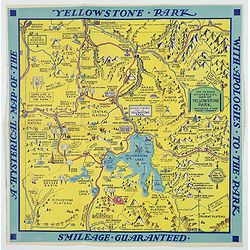
A Hysterical Map of the Yellowstone Park. . .
A funny 1936 pictorial map of Yellowstone Park, that was 'hatched and scratched' by the American printer and humourist Jolly Elmer Lindgren. This wonderful map covers the...
- $475 / ≈ €418
Place & Date: Spokane, 1936
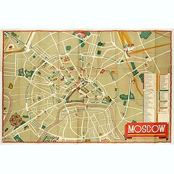
Moscow.
Fantastic pictorial map of Moscow designed to draw tourists to the new Soviet Union.The cultural vitality of Moscow in the early years of the Soviet Union is the focal po...
- $750 / ≈ €661
Place & Date: Moscow, c. 1938
![Mapa geral do Brasil / organizado pelos J. Carneiro da Silva e Pedro Voss. [Together with] Micro geografia do Brasil. [Together with] Pequeno Mapa do Brasil.](/uploads/cache/45466-250x250.jpg)
Mapa geral do Brasil / organizado pelos J. Carneiro da Silva e Pedro Voss. [Together with] Micro geografia do Brasil. [Together with] Pequeno Mapa do Brasil.
Large folding national map published by "Comp. Melhoramentos de São Paulo Industrias de Papel". Nova edicao revista 1946. Figurs all states. "Futuro Distr...
- $300 / ≈ €264
Place & Date: São Paulo, 1946
![[Pictorial map of Georgia (Caucasus)].](/uploads/cache/47135-250x250.jpg)
[Pictorial map of Georgia (Caucasus)].
A scarce pictorial map of a region in Georgia in the Caucasus. Map is entirely in Russian, complete with legend at base of map, with small thumbnail pictures and symbols ...
- $150 / ≈ €132
Place & Date: Moscow, 1963
![[Afghanistan].](/uploads/cache/44611-250x250.jpg)
[Afghanistan].
A scarce Russian relief map (in Russian) of Afghanistan published in Moscow during the Soviet occupation of the country during the early 1980s. Complete with a separate b...
- $250 / ≈ €220
Place & Date: Moscow, 1982