Search Listings matching "chatelain"
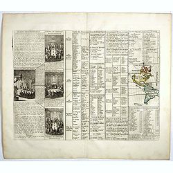
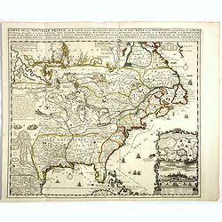
Carte du gouvernement de l'Amerique.
A double page sheet including a fine map of America, with California with indented northern coastline (130x92mm.) and New Mexico extending across most of western North Am...
- $300 / ≈ €264
Place & Date: Amsterdam, 1705
Carte du gouvernement de l'Amerique.
A double page sheet including a fine map of America, with California with indented northern coastline (130x92mm.) and New Mexico extending across most of western North Am...
- $300 / ≈ €264
Place & Date: Amsterdam, 1705

Genealogie de Mahomet.
Fine example of Chatelain's attractive plate showing the genealogy of Mahomet. Zacharie Chatelain (d.1723) was the father of Henri Abraham (1684-1743) and Zacharie Junior...
- $75 / ≈ €66
Place & Date: Amsterdam, 1714

Nouvelle carte de geographie de .. Meridionale de l'Amerique
Chatelain's map of South America. The title is in two lines across the map. The tracks of Magellan, de la Maire, de Mendana, etc. are shown.On each side, borders appear a...
- $250 / ≈ €220
Place & Date: Amsterdam, 1719
![[Lot of 6 plates] Carte de la Laponie Suedoise.](/uploads/cache/36604-250x250.jpg)
[Lot of 6 plates] Carte de la Laponie Suedoise.
Chatelain's map of Lapland (170 x 205mm.) , with views of indigenous people and customs (including Reindeer!), etc.Together with 4 other engraved pages with views of indi...
- $300 / ≈ €264
Place & Date: Amsterdam, 1719
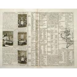
Carte De L'Europe Suivant Les Plus Nouvelles Observations De Messieurs De L'Academie Des Sciences . . .
Includes Iceland, and Russia in the north as well as the Black Sea and the northern tip of Africa in the south. Two tables, listing more than 175 countries along with the...
- $300 / ≈ €264
Place & Date: Amsterdam, 1719

Nouvelle carte du royaume de Pologne, divisée selon..
Chatelain's map of Poland. The title is in two lines across the map. On bottom border appears an index to the map's contents. At the top of the map appear historical rema...
- $750 / ≈ €661
Place & Date: Amsterdam, 1719

Genealogie des anciens empereurs Tartares,. . .
In lower part a map Russia including Tartary and Korea (158 x 290mm.), flanked by text in French. In top a family tree of the descendants of Genghis Khan.From Chatelain's...
- $75 / ≈ €66
Place & Date: Amsterdam, 1719

Nouvelle carte du royaume de Pologne, divisée selon..
Chatelain's map of Poland. The title is in two lines across the map. On bottom border appears an index to the map's contents. At the top of the map appear historical rema...
- $1100 / ≈ €969
Place & Date: Amsterdam, 1719
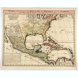
Carte contenant le Royaume du Mexique et la Floride.
This is a derivative of Delisle's landmark map of the southern part of North America.The detailed map shows many English settlements along the East Coast and carefully no...
- $1000 / ≈ €881
Place & Date: Amsterdam, 1719

Carte contenant le Royaume du Mexique et la Floride.
This is a derivative of Delisle's landmark map of the southern part of North America. The detailed map shows many English settlements along the East Coast and carefully n...
- $900 / ≈ €793
Place & Date: Amsterdam, 1719
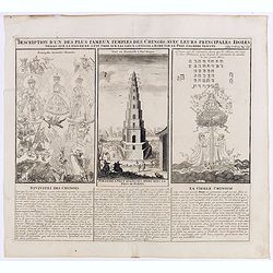
Description d'un des plus fameux temples des Chinois..
This impressive engraving is a wonderful example of Chatelain’s elegant plates.Divided in 3 panels, respectively showing the most important gods in the Chinese deities ...
Place & Date: Amsterdam, ca. 1720
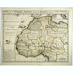
Carte de la barbarie, Nigritie et de la Guinée avec les pays voisins . . .
This great map of western Africa is based on Guillaume Delisle's map. It covers from the Barbary coast to below the equator. There is a mass of geographic detail and nota...
- $300 / ≈ €264
Place & Date: Amsterdam, 1720
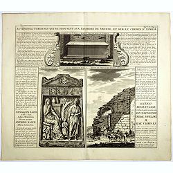
Antiquez curieuses qui se trouvent aux environs de Smyrne, et sur le chemin d'Ephese.
Folio sheet describing and depicting ancient Greek monuments and ruins in Smyrna (Izmir). From Chatelain's monumental 7 volume "Atlas Historique". Henri Abraham...
- $75 / ≈ €66
Place & Date: Amsterdam, 1720

Description te vue de la Place d'Ispahan . . .
Pair of decorative views showing the Royal Palace at Isfahan (Esfahan) and the Royal Mosque of Abas the Great. From Chatelain's monumental 7 volume "Atlas Historique...
- $125 / ≈ €110
Place & Date: Amsterdam, 1720
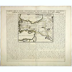
Carte De L'Asie Inferieure Selon Les Auteurs Anciens, Enrichie de Remarques Historiques sur les Changemens qui y sont arrivez.
Text page with inset map (220x269.mm.) of Turkey, including Cyprus from Chatelain's monumental 7 volume "Atlas Historique". Henri Abraham Chatelain (1684 – 17...
- $200 / ≈ €176
Place & Date: Amsterdam, 1720
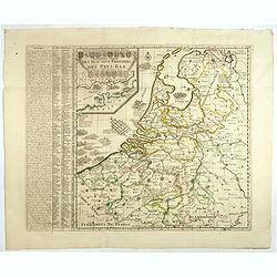
Nouvelle Carte des dix-sept Provinces des Pays-Bas.
Map of the 17 provinces of the Netherlands. In an inset upper left corner 17 coats of arms of each province and vignettes. The Channel is filled with Naval battles fought...
Place & Date: Amsterdam, ca. 1720

Description des habits des Persans..
This impressive engraving is a wonderful example of Chatelain’s elegant plates.Ornamented with numerous vignettes showing the costumes of the ancient Persians.General i...
- $150 / ≈ €132
Place & Date: Amsterdam, ca. 1720

Description de la Celebre Mosquee de Com, Des Tombeaux Des Deux Derniers Rois de Perse qu'elle Renferme & du Grand Caravan-Serai De La Ville De Cachan Le Puls Magnifique de Tout L'Orient ...
Four views on one page with descriptive text showing the interior of the Mosquek, including the Sepulchre of Abas the Second and Sefy the First, along with the Tomb of th...
Place & Date: Amsterdam, 1720

Carte genealogique de la maison des Valois. . .
This impressive engraving is a wonderful example of Chatelain’s elegant plates from his "Atlas Historique, Ou Nouvelle Introduction A L’Histoire …", Tom 7...
- $50 / ≈ €44
Place & Date: Amsterdam, ca. 1720
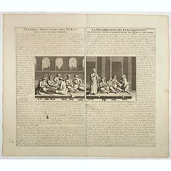
Viandes & breuvages des Turcs . . . / La manière dont les Turcs mangent . . .
Interesting sheet with a detailed views illustrating the lunch time in turkey, with descriptive French text, from Chatelain's monumental 7 volume Atlas Historique. In upp...
- $55 / ≈ €48
Place & Date: Amsterdam, ca. 1720

Carte geographique de l'Asie mineure avec un etat des premiers rois. . .
Map of the Mediterranean. This impressive engraving is a wonderful example of Chatelain’s elegant plates from his "Atlas Historique, Ou Nouvelle Introduction A L�...
- $120 / ≈ €106
Place & Date: Amsterdam, ca. 1720

Description, figure et qualité de l'arbre, du café, avec la manière de le cultiver et d'en cueillir le fruit.
Decorative copperplate engraving showing a coffee tree, plant and fruit, with an lengthy description about its growing process.From Chatelain's monumental 7 volume "...
- $75 / ≈ €66
Place & Date: Amsterdam, 1720

Carte des Grisons et des Communautez qui Composent leurs Ligues, les Etats de St. Gal, Neuchastel, Geneve et Quelques Autres Etats Alliez des Suisse.
This finely engraved sheet provides the history of various cities and regions allied with Switzerland at the beginning of the eighteenth century. The top section of the s...
- $150 / ≈ €132
Place & Date: Amsterdam, 1720

Représentation du parlement d'Angleterre, les chambres assemblées . . .
Engraving showing the British Parliament and an assembly before the King of England. From Chatelain's Atlas Historique, 1732-1739. In upper right margin: 'Tom. 7. No 26.H...
- $80 / ≈ €70
Place & Date: Amsterdam, 1720
Carte genealogique de la famille Royale de Brunswick . .
A very detailed composite sheet with a genealogical table of the German royal families of Brunswick, Luneburg and Hanover, with descriptive French textZacharie Chatelain ...
- $50 / ≈ €44
Place & Date: Amsterdam, ca. 1720

Carte du Gouvernement Ecclesiastique de France Divise en ses Archeveschez, Eveschez, Archidiaconnez, Archipretrez, Doyennez, et Parroisses.
This impressive plate provides a comprehensive list of the ecclesiastical divisions in the country with their corresponding coats of arms. A small inset map depicts the l...
- $55 / ≈ €48
Place & Date: Amsterdam, 1720

Vue et description de la Ville de Meaco Capitale du Japon. . .
Top part of the print shows the town of Meaco (Kyoto) at that time the capital of Japan, with a coach and horses in the foreground. Other parts show among other things th...
- $450 / ≈ €396
Place & Date: Amsterdam, 1720

Carte des Indes, de la Chine & des Isles de Sumatra, Java &c..
This fine and quite detailed general map extends from northern Japan to Timor and from India to New Guinea.There are very good details of towns and trade routes in modern...
Place & Date: Amsterdam, 1720
Carte de la Nouvelle France, ou se voit le cours des Grandes Rivieres de S. Laurens & de Mississipi..
Derived from de Fer's 1718 map, from west of the Mississippi it contains a mass of inland detail with notes and vignettes of the indigenous peoples and fauna of North Ame...
Place & Date: Amsterdam, 1720
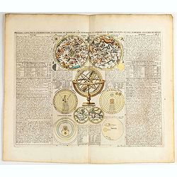
Premiere carte pour l'Introduction a l'histoire du monde, ou l'on remarque la Sphere, le Globe Celeste. . .
Featuring a small double hemisphere world map, showing California as an island, North and South Polar celestial hemispheres, an Armillary Sphere, below with smaller circu...
- $500 / ≈ €440
Place & Date: Amsterdam, 1720
Carte des pavillons accompagnée d'observations pour en faire comprendre le blazon et les différentes devises aussy bien que d'une table alphabétique pour les trouver facilement.?
Map of 88 marine flags, including Malta, Turkey, Middelburg, Amsterdam, Portugal, Monaco, Tuscany, China, Nanking, the French Royal flag, French admiralty flag and mercha...
Place & Date: Amsterdam, 1720

Carte Geographique du Royaume de France, avec des remarques curieuses sur l'ancienne, et la nouvelle geographie.
Map of France with a key table to the towns on both sides.Zacharie Chatelain (d.1723) was the father of Henri Abraham (1684-1743) and Zacharie Junior (1690-1754).They wor...
Place & Date: Amsterdam, ca. 1720

Succession Des Empereurs Du Japon Avec Une Description Du Meurtre De L'Empereur Cubo Et La Reception Des Ambassadeurs Hollandais. . .
The plate is showing the murder of the Emperor Cubo at Kyoto, the arrival of one of the early Dutch embassies.A small map of Honshu in a central panel. Plate from his &qu...
Place & Date: Amsterdam, 1720
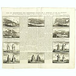
Vue et description des principales villes de l'Armenie et de la Georgie avec les habillements des femmes du pays, et ceux des prêtres et religieux armeniens. . .Tom: V N° 11 Pag: 28
View and description of the principal Armenian and Georgian cities with illustrations of Armenian women's garments as well as priests' and monks' clothing. The views are ...
Place & Date: Amsterdam, ca 1720

Carte ancienne et moderne de l'Irlande, avec quelques remarques sur son gouvernement . . .
Map of Ireland, based upon the ancient and modern cartographic information as of the beginning of the 18th Century. From Chatelain's monumental 7 volume "Atlas Histo...
- $200 / ≈ €176
Place & Date: Amsterdam, 1720

Particularitez Curieuses de l'Ile de St. Christophle et de la Province de Bemarin . . .
Six meticulously detailed and engraved scenes of the island of St. Kitts, also known as Saint Christopher, and the province of Bemarin, indigenous plants, animals, reptil...
Place & Date: Amsterdam, 1720

Carte du gouvernement d'Angleterre où l'on représente l'Etat des officiers de Guerre. . .
Decorative map on the British Isles, with idyllic scenes showing councils of the various military officers of the British Isles. Henri Abraham Chatelain (1684 – 1743) w...
- $50 / ≈ €44
Place & Date: Amsterdam, 1720
Carte genealogique des comtes de Dreux, des Seigneursde Beaussart . . .
Genealogical chart of the earls of Dreux, from Chatelain's monumental 7 volume "Atlas Historique". Henri Abraham Chatelain (1684 – 1743) was a Huguenot pastor...
- $50 / ≈ €44
Place & Date: Amsterdam, 1720

Nouvelle Carte des Differents Etats de la Monarchie Françoise Sous Iule Cesar, Sous les Rois de la Premiere, de la Seconde . . .
Four maps of France surrounded by historical and genealogical information to the history, chronology, ancient and modern genealogy of the french monarchy.Henri Abraham Ch...
- $75 / ≈ €66
Place & Date: Amsterdam, 1720

Carte Pour l'Introduction a l'Histoire d'Angleterre, ou l'on Voit son Premier Gouvernement, et l'Etat Abrege de cette Monarchie sous les Empereurs Romains, et sous les Rois Saxons.
The sheet includes a large inset map of Roman Britain including the English Channel and the western coast of France (200 x 255mm.). It also provides a wealth of informati...
- $200 / ≈ €176
Place & Date: Amsterdam, 1720

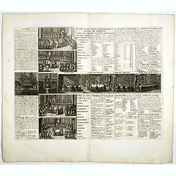
Carte du gouvernement ecclesiastique d'Angleterre . . .
Elegant engraving of the ecclesiastical government of England, with an engraving showing three images: in the centre, an ecclesiastical assembly (Convocation of the Clerg...
- $100 / ≈ €88
Place & Date: Amsterdam, 1720
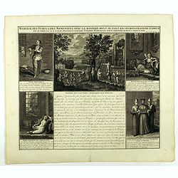
Mariage des Turcs & des Armeniens, avec la ma niere dont se font les demonstrations d'amour . . .
Showing the marriage rituals and lives of Turks and Armenians. Five engravings set round a text panel in French. From Chatelain's monumental 7 volume "Atlas Historiq...
- $150 / ≈ €132
Place & Date: Amsterdam, 1720

Vue et description de Bethleem et de Nazareth . . .
Decorative panoramic view of Bethlehem and Nazareth, among 3 other views of the Hall of the Annunciation and Church of Cana .From Chatelain's monumental 7 volume "At...
- $200 / ≈ €176
Place & Date: Amsterdam, 1720

Carte de l'Ile de Java: partie Occidentale, partie Orientale, Dressée tout nouvellement sur les Mémoirs les plus exacts, Avec une Table des principales villes de cette Ile. . .
One of the finest large-scale maps of Java, giving good information regarding the VOC settlements An inset plan of Batavia and clearly indicated rice fields, mountains, f...
- $1500 / ≈ €1321
Place & Date: Amsterdam, 1720

Carte pour servir à l'intelligence de l'histoire de la chronologie et de la géographie des empires des Assiriens, des Perses, des Egyptiens et des Chinois.
Interesting sheet with a map of the classical world showing the empires of the Assyrians, Persians, Egyptians and Chinese, with descriptive French text, from Chatelain's ...
Place & Date: Amsterdam, 1720
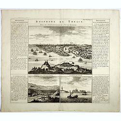
Bosphore de Thrace.
This handsome folio sheet present three views of the strategically important Bosporus. At top is a large decorative bird's-eye view of Istanbul as viewed from across the ...
Place & Date: Amsterdam, 1720

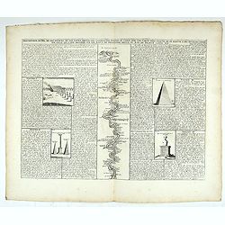
Description des piramides d'Egypte tant au départ qu'au dehors . . .
Engraved text page with 5 views of the pyramids and an image of the Sphinx. From Chatelain's monumental 7 volume "Atlas Historique".Henri Abraham Chatelain (168...
- $36 / ≈ €32
Place & Date: Amsterdam, 1720
Carte du gouvernement militaire de la République de Venise . . .
Very decorative folio sheet with five engraved views in Venice: "Vue de la Palace de St. Marc" (Piazza San Marco), a birds-eye map of "L'Arcenal", &qu...
Place & Date: Amsterdam, 1720

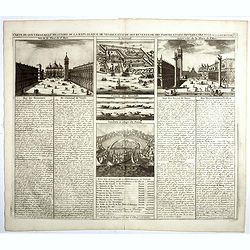
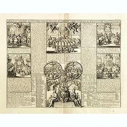
Carte du gouvernement civil ecclésiastique de moscovie, l'état des revenus et l'ordre de la justice et des officiers de la cour.
Interesting sheet with a detailed plan of Moscow, plus two large coats-of-arms, with descriptive French text, from Chatelain's monumental 7 volume Atlas Historique. In up...
- $950 / ≈ €837
Place & Date: Amsterdam, 1720

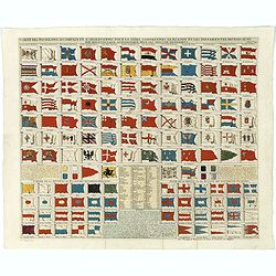
Carte des pavillons accompagnée d'observations pour en faire comprendre le blazon et les différentes devises aussy bien que d'une table alphabétique pour les trouver facilement.
A plate of 88 marine flags, including Malta, Turkey, Middelburg, Amsterdam, Portugal, Monaco, Tuscany, China, Nanking, the French Royal flag, the French admiralty flag an...
- $1200 / ≈ €1057
Place & Date: Amsterdam, 1720
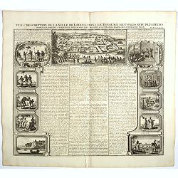
Vue et description de la Ville de Lovango dans le Royaume du Congo. . .
On top a large view of the fabled city of Lovango, text surrounded by ten vignettes of the people and ceremonies of the Kingdom of Congo.Zacharie Chatelain (d.1723) was t...
Place & Date: Amsterdam, 1720

Vue & description de l'Eglise du Saint Sepulchre tant par dehors que dedans . . .
Shows various interiors and exterior views of the Church of the Holy Sepulcher in Jerusalem. From Chatelain's monumental 7 volume "Atlas Historique".Henri Abrah...
Place & Date: Amsterdam, 1720
Carte du gouvernement ecclesiastique civil et militaire de l'Empire de l'ordre teutonique et de Malte et des villes anseatiques.
Interesting sheet with a detailed series of views showing the various councils of the Hanseatic League, including the councils of war, finance, state and the college of t...
- $75 / ≈ €66
Place & Date: Amsterdam, 1720
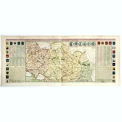
Carte generale des Etats du Czar. Empereur de Moscovie, ou L'on voit ce que ce prince possede en Europe ..
Impressive map of Russia Tartary and part of China with key tables to the towns. Depicting the different states belonging to the Czar in Asia and Europe, showing the path...
- $900 / ≈ €793
Place & Date: Amsterdam, ca. 1720
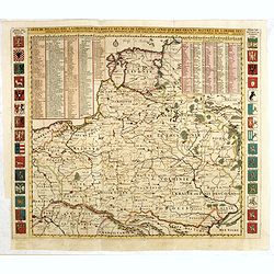
Carte De Pologne Avec La Chronologie Des Rois Et Des Ducs De Lithuanie, Ainsi Que Des Grands M. De L'Ordre Teutonique Les Evechez et Archeveches, et Les Armes Des Provinces . . .
Map of Poland with a key table to the towns, and 30 coats of arms on both sides, extending south the Black Sea. From Chatelain's monumental 7-volume "Atlas Historiqu...
- $1000 / ≈ €881
Place & Date: Amsterdam, 1720

Carte du gouvernement militaire d'Angleterre où l'on représente l'état des officiers de guerre et celui des forces de terre et de mer.
Interesting sheet with a decorative map on the British Isles, with idyllic scenes showing councils of the various military officers of the British Isles, with descriptive...
Place & Date: Amsterdam, 1720

Carte de l'Ile de Java. . .
An inset plan of Batavia and clearly indicated rice fields, mountains, forests, towns in profile, and even elephants, suggesting the wealth of detail found on this map. M...
Place & Date: Amsterdam, 1720
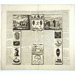
Carte qui contient la manière.. Niagara..
A series of 12 engravings together with descriptive text, derived from the works of Lahontan and Hennepin, illustrating the methods of the Indians hunting buffalo and sim...
Place & Date: The Hague 1720
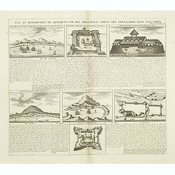
Vue et Description de Quelques-Uns des Principaux Forts des Hollandois dans les Indes .
Interesting sheet with seven detailed views illustrating the most important Dutch V.O.C. trading outposts and fortified colonial possessions in the East Indies, including...
Place & Date: Amsterdam, 1720

Succession Des Empereurs De la Chine divisée en XXII. Familles.
Showing successions of the Emperors of China divided into 22 families, copper engraved plate from "Atlas Historique". Zacharie Chatelain (d.1723) was the father...
- $100 / ≈ €88
Place & Date: Amsterdam, 1720
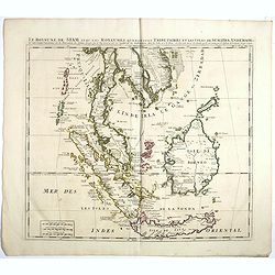
Le Royaume de Siam avec Les Royaumes Qui Luy sont Tributaries & c.
Influential map of Southeast Asia, including modern day Thailand, southern Vietnam, Cambodia, Malaysia, Singapore, Borneo, Sumatra and Java. Chatelain incorporated inform...
Place & Date: Amsterdam, c.1720

Carte pour servir à l'intelligence de l'histoire de la chronologie et de la géographie des empires des Assiriens, des Perses, des Egyptiens et des Chinois.
Interesting sheet with a map of the classical world showing the empires of the Assyrians, Persians, Egyptians and Chinese, with descriptive French text, from Chatelain's ...
- $75 / ≈ €66
Place & Date: Amsterdam, 1720
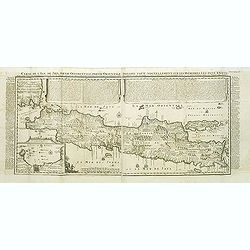
Carte de l'Ile de Java.
An inset plan of Batavia and clearly indicated rice fields, mountains, forests, towns in profile and even elephants suggest the wealth of detail found on this map. Modele...
Place & Date: Amsterdam, 1720

Carte du Gouvernement de la Cour d'Espagne. . .
Engraved text sheet, providing a detailed description of the infrastructure of Spain's ecclesiastical and military government as well as information listed in a lengthy t...
- $75 / ≈ €66
Place & Date: Amsterdam, ca. 1720

Nouvelle carte d'Angleterre, d'Ecosse et d'Irlande, avec des instructions ..
Striking large folding map of the British Isles, with large insets of the Eastern and Western Hemispheres and the coats of arms for England, Ireland, Scotland and Wales. ...
- $200 / ≈ €176
Place & Date: Amsterdam, 1721

L'Italie dans son Premier Etablissement sous la Republique Romaine. . .
Map of Italy when first established under the Roman Republic after the division by Ayuguste Caesar, its various Papal governments: ancient Rome and its surround dings, a ...
Place & Date: Amsterdam, 1728

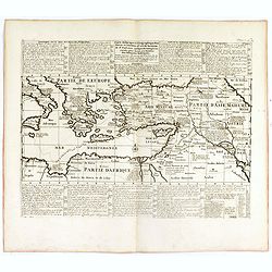
Carte de L'Empire des Turcs en Asie & en Afrique..
Including the Arabian Peninsula, Egypt, Cyprus, and part of the Mediterranean. In the upper right corner is a large Caspian Sea, filled with notes. To the right, the Rive...
Place & Date: Amsterdam, 1728
Carte historique et géographique pour servir à l'Histoire Sainte et à la Vocation de Saint Paul, avec quelques remarques curieuses pour servir à l'Histoire des Antiquités judaïques.
Interesting sheet with a map of the travels of Saint Paul, including eastern part of Europe, Asian continent and part of north Africa, with descriptive French text, from ...
Place & Date: Amsterdam, 1728

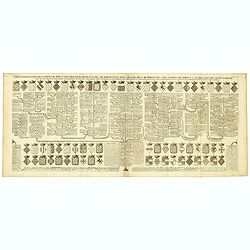
Généalogie des Cazrs de Moscovie ou empereurs de la grande Russie . . .
Genealogical tree, showing the lineage of the Russian Czar's, dating back to 840 according to Hubner. Published by Henri Abraham Chatelain (1684 – 1743) a Huguenot past...
- $250 / ≈ €220
Place & Date: Amsterdam, 1728

Genealogie des anciens empereurs mogols,. . .
Text sheet with two inset maps of "Carte de l'empire du grand Mogol (122x158mm.) and inset map of Kahsmire "carte nouvelle du royaume de Kachemire" (120x15...
- $150 / ≈ €132
Place & Date: Amsterdam, 1728

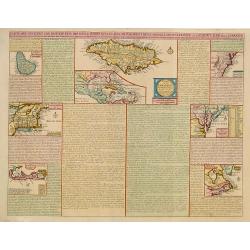
Carte qui contient..Iles & Terres..L'Amerique..Jamaique..
Eight maps on one sheet. From Chatelain's Atlas Historique et Méthodique . Including maps of Bermuda, Jamaica, New England with Long Island, Carolina, Chesapeake and Del...
Place & Date: Amsterdam, 1728
Description du Nil, de ses sources, de son cours depuis les cataractes jusques le Caire . . .
Detailed map of the course of the Nile, from the cataracts of the Nile at the south (top of the image) to Caïro and Giza. At the right, one of the Pyramids is shown (140...
Place & Date: Amsterdam, 1728
Carte qui contient..Iles & Terres..L'Amerique..Jamaique..
Eight maps on one sheet. From Chatelain's Atlas Historique et Méthodique . Including maps of Bermuda, Jamaica, New England with Long Island, Carolina, Chesapeake and Del...
Place & Date: Amsterdam 1728
![[No title] Mongol.](/uploads/cache/39729-250x250.jpg)
[No title] Mongol.
Interesting sheet with four detailed engravings illustrating Mongol's life scenes. In upper right margin: 'Tom. V. No 43. Pag: 116.Henri Abraham Chatelain (1684 – 1743)...
- $150 / ≈ €132
Place & Date: Amsterdam, 1728

Carte Historique et Geographique pour Introduire a l' Intelligence de l'Histoire de Savoye . . .
Folio sheet with an attractive map of the border region of France, Switzerland and Italy. An inset map of the fortification of Torino and the Palace of Venerie. Cartouche...
- $30 / ≈ €26
Place & Date: Amsterdam, 1728
Carte du Gouvernement Civil de France.
This impressive engraving is a wonderful example of Chatelain’s elegant plates. It provides a detailed description of the infrastructure of the French government. Ornam...
- $75 / ≈ €66
Place & Date: Amsterdam, 1728
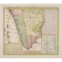
Carte nouvelle des Terres de Cucan..
Prepared by H.Reland (1676-1718) a professor active in Utrecht and specialized in Asian languages, geography and religions. His first map was a map of Japan copied after ...
Place & Date: The Hague, 1728

Carte Particuliere De L'Egypte, De La Nubie et de L'Abyssinie, Dressee sur les Memoires les plus Nouveaux & les Observation les plus exactes.
Including the Arabian Peninsular, Egypt, north eastern part of Africa, Cyprus and part of the Mediterranean.Based on the work of Guillaume Delisle. It is a very detailed ...
- $400 / ≈ €352
Place & Date: Amsterdam, 1728

Genealogie des empereurs Mogols . . .
Text sheet with two inset maps of "Carte de l'empire du grand Mogol (122x158mm.) and inset map of Kahsmire "carte nouvelle du royaume de Kachemire" (120x15...
- $150 / ≈ €132
Place & Date: Amsterdam, 1728