Search Listings matching "celestial"
![[The creation of the world - First day]](/uploads/cache/24509-250x250.jpg)
[The creation of the world - First day]
Attractive page from the Nuremberg Chronicle, showing the creation of the world: the First Day, showing the celestial choir (God\'s creation of the angels) surrounding th...
Place & Date: Nuremberg, 12 July 1493

Introductio ad Geographiam. Caput I.
Four pages with an introduction to geography in Latin with woodcut illustrations of diagrams of the solar system.
- $200 / ≈ €176
Place & Date: Amsterdam, 1606
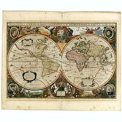
Nova Totius Terrarum Orbis Geographica..
The first of four states of the map. French text on verso. One of the most beautiful world maps ever engraved and one of the most influential in promulgating the Californ...
Place & Date: Amsterdam, 1630-1633
![[Title page] Nouveau Theatre Du Mond ou Nouvel Atlas . . .](/uploads/cache/43280-250x250.jpg)
[Title page] Nouveau Theatre Du Mond ou Nouvel Atlas . . .
The title page from Joahannes Janssonius / Hondius's Atlas Novus. Marvelous 18 coat of arms, armillary sphere, celestial and terrestrial globes and beautifully engraved f...
Place & Date: Amsterdam, 1638

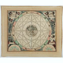
N°5. Horologium Horizontale signa zodiaci ascendentia : ec.cotinens ad latitud XLVIIII : GR: XXIIII: SCR ee.
This beautiful engraving is a horological diagram with at bottom a 32-point wind rose and signed underneath "M:Franciscus Ritter N fac A° 1640".Remarkable for ...
- $400 / ≈ €352
Place & Date: Nuremberg 1640

N°3. Horologium Horizontale Horas a meridie et media nocte Numeratas continens ad latitudinem XLIX GR XXIII Minut ec.
This beautiful engraving is a horological diagram with a 32-point wind rose at the bottom, signed underneath "M:Franciscus Ritter N fac A° 1640."It is remarkab...
Place & Date: Nuremberg 1640

N°7. Horologium Horizontale parallelos Horizontis Exhibens ad Poliarctici elevationem XLVIIII Grad XXIIII Scrupul Ec.
This beautiful engraving is a horological diagram with at bottom a 32-point wind rose and signed underneath "M:Franciscus Ritter N fac A° 1640".Remarkable for ...
- $750 / ≈ €661
Place & Date: Nuremberg 1640

N°2. Horologium Horizontale Paralle los Horizontis cum Hor: a meridie numeratis ostendens.
This beautiful engraving is a horological diagram with at bottom a 32-point wind rose and signed underneath "Franciscus Ritter N fac:".Remarkable for the elabor...
- $750 / ≈ €661
Place & Date: Nuremberg 1640
![[Title page] Theatrum orbis Terrarum sive Atlas Novus pars Tertia.](/uploads/cache/43695-250x250.jpg)
[Title page] Theatrum orbis Terrarum sive Atlas Novus pars Tertia.
Glorious mid-seventeenth century engraved frontispiece by Joan and Cornelis Blaeu from the third part of his 'Theatrum Orbis Terrarum'. Finely decorated with a pair of te...
- $350 / ≈ €308
Place & Date: Amsterdam, 1650
![[Title page from Theatrum orbis Terrarum, with past-on]](/uploads/cache/43860-250x250.jpg)
[Title page from Theatrum orbis Terrarum, with past-on]
The frontispiece of the third part of the 'Theatrum', by Johan Blaeu. Heightened with goldDecorated with terrestrial and celestial globes and to the left Ptolemy (with sp...
Place & Date: Amsterdam, ca. 1650
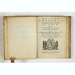
Tweevoudigh onderwiis van de Hemelsche en Aerdsche Globen; Het een Na de meyning van Ptolemeus met een vasten Aerdkloot...
Tweevoudigh onderwiis van de Hemelsche en Aerdsche Globen; Het een Na de meyning van Ptolemeus met een vasten Aerdkloot; Het ander Na de Natuerlijcke stelling van N. Cope...
Place & Date: Amsterdam, 1655
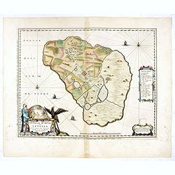
Insula Huaena sive Venusia a Guiljelmo Blaeu cum sub Tychone Astronomiae operam daret, delineata.
Decorative map of the island Hvan in the Danish Sound. In the center Tycho Brahe's famous observatory Uraniborg established in 1576, under the patronage of Frederick II, ...
Place & Date: Amsterdam, 1659

Situs Terrae Circulis Coelestibus circundatae..
A celestial chart showing a large globe centered on Australia and the Pacific, with California as an island, South East Asia, encircled by the zopdiacal band according to...
Place & Date: Amsterdam, Janssonius, 1660
![Itroductio. [with sphere.]](/uploads/cache/23703-250x250.jpg)
Itroductio. [with sphere.]
Introduction leaf from a French text edition of Atlas Ma1or
Place & Date: Amsterdam, 1662
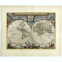
Nova et Accuratissima Totius Terrarum Orbis Tabula.
Since its appearance as an Appendix in 1630, the atlas launched by Willem Blaeu and continued by his son Joan had expanded greatly. But despite many new regional maps the...
Place & Date: Amsterdam, 1662

Le monde et sa disposition suivant Ptolomée.
The Christian Aristotelian cosmos. Ptolemy accepted the following order for celestial objects in the solar system: Earth (center), Moon, Mercury, Venus, Sun, Mars, Jupite...
- $150 / ≈ €132
Place & Date: Paris, 1667
![[Title page to] Atlas mayor, o geographia Blaviana : Que contiene las cartas, y descripciones de Partes Orientales de Europa.](/uploads/cache/29952-250x250.jpg)
[Title page to] Atlas mayor, o geographia Blaviana : Que contiene las cartas, y descripciones de Partes Orientales de Europa.
Title page from a Spanish text edition of the Atlas Major. Ionic portico with celestial and terrestrial globes. To the left is Ptolemy with a sphere and a pair of compass...
Place & Date: Amsterdam, c.1672
DE LA SPHERE. Figure XXXVII. 103.
Fine celestial map depicting three constellations in allegorical form. The 3 spheres are suspended above an engraved scene of a harbor on a moonlit night.From the French ...
- $100 / ≈ €88
Place & Date: Paris, 1683
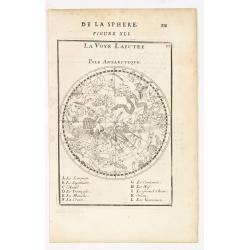
La Voye Laictee, Pole Antarctique.
Nice small celestial chart showing the southern sky with eleven major constellations named.From the French text edition of Description d'Univers.. (5 volumes), 1683. By A...
- $300 / ≈ €264
Place & Date: Paris, 1683
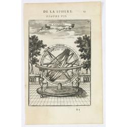
Des Colures.
Appealing print focused on an armillary sphere showing the equinoctial and the solstitial colures.From the French text edition of Description d'Univers.. (5 volumes), 168...
- $150 / ≈ €132
Place & Date: Paris, 1683
![La Voye Laictee, Pole Arctique. [Figure XXXIX. On verso]](/uploads/cache/22619-250x250.jpg)
La Voye Laictee, Pole Arctique. [Figure XXXIX. On verso]
Nice small celestial chart showing the northern sky with ten major constellations named. Fine engravure on verso depicting a cherubin using an astronomical telescope.From...
- $200 / ≈ €176
Place & Date: Paris, 1683
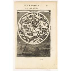
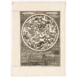
DE LA SPHERE. Figure XXXVI.
A fine celestial map depicting the southern constellations in allegorical form. Fully engraved, it presents a landscape with some sailing ships on the background.From the...
- $200 / ≈ €176
Place & Date: Paris, 1683
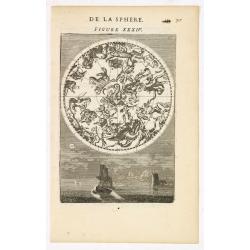
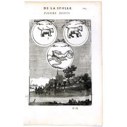
DE LA SPHERE. Figure XXXIV.
A fine celestial map depicting the northern constellations in allegorical form. Fully engraved, it presents 2 sailing ships and a harbour on the background.From the Frenc...
- $300 / ≈ €264
Place & Date: Paris, 1683
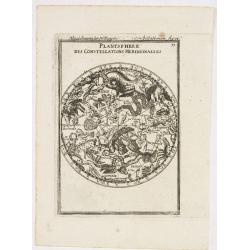
Planisphere des Constellations Meridionalles.
A fine celestial map depicting the southern constellations in allegorical form.From the German text edition of Description d'Univers.. (5 volumes), 1683. By Allain Mannes...
- $200 / ≈ €176
Place & Date: Frankfurt, 1684
![[2 maps] Nieuwe Hemels Spiegel waer door den hemel, aerde en zee dadelik kan afgemeten werden. Noyt gesien en dat op alles Polus hooghten seer noodig voor Stierlieden.](/uploads/cache/49046-(1)-250x250.jpg)
[2 maps] Nieuwe Hemels Spiegel waer door den hemel, aerde en zee dadelik kan afgemeten werden. Noyt gesien en dat op alles Polus hooghten seer noodig voor Stierlieden.
A set of two copper engravings made by Andreas van Luchtenburg in Rotterdam, published separately by Cornelis Danckerts. Nieuwe Hemels Spiegel waer door den hemel, aerd...
Place & Date: Rotterdam, Amsterdam, ca. 1684
(Celestial) Fig. 36.
A fine celestial map depicting the southern constellations in allegorical form. Fully engraved, it presents a landscape with some sailing ships on the background.From the...
- $200 / ≈ €176
Place & Date: Frankfurt, 1684
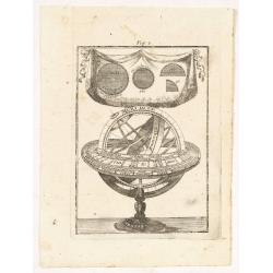
Fig. 3.
Appealing print depicting an armillary sphere.From the German text edition of Description d'Univers.. (5 volumes), 1683. By Allain Manneson Mallet (1630-1706), a well tra...
- $150 / ≈ €132
Place & Date: Frankfurt 1684
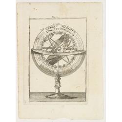
Fig. 4.
Appealing print focused on an armillary sphere.From the German text edition of Description d'Univers.. (5 volumes), 1683. By Allain Manneson Mallet (1630-1706), a well tr...
- $150 / ≈ €132
Place & Date: Frankfurt, 1684
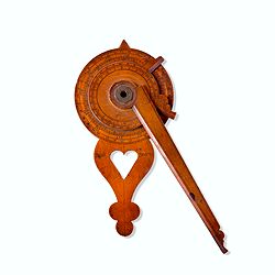
Nocturlabe in boxwood and brass.
Nocturlabe in boxwood and brass, the wheels maintained by a central nut presenting an annual calendar divided into months and days, an hour disc and a mobile alidade, the...
Place & Date: England, ca. 1700

Planisferii Celesti, Calcolati Per L'Anno MDCC, Corretti, Et Aumenati Di Molte Stelle . . .
Double hemisphere celestial map showing a new and more scientific depiction of the heavens. The remarkable Vincenzo Coronelli (1650-1718), was a Franciscan Friar and appo...
Place & Date: Venice, 1700
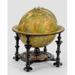
A very rare Louis XIV celestial globe by Guillaume De L'Isle, Paris, 1700, with his first address "Rue des Canettes".
Decorated with constellation figures, backgrounds in green, constellation figures hightened in red and pale colors, metal axis, brass meridian circle, graduated on one fa...
- $25000 / ≈ €22024
Place & Date: Paris, 1701
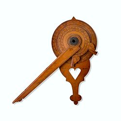
Nocturnal in boxwood and brass.
Nocturlabe in boxwood and brass, the wheels maintained by a central nut presenting an annual calendar divided into months and days, an hour disc and a mobile alidade, the...
Place & Date: England, Thomas Cooper, dated 1701
Typus aspectuum, oppositionum et conjunctionum…
A celestial chart with a circular projection map of the earth, centered in the North Pole, concentrates upon the planets' opposition and conjunction. With two diagrams in...
Place & Date: Amsterdam, 1708
![[A magnificent 18 inch. (46 cm.) diameter celestial globe] URANOGRAPHIA / SYDERUM ET STELLARUM / in Singulis Syderibus conspicuarum / exhibens Delineationem accuratissimam, / qua / ex Observationibus Astronomi plane Singularis / IOHANIS HEVELII...](/uploads/cache/48959-250x250.jpg)
[A magnificent 18 inch. (46 cm.) diameter celestial globe] URANOGRAPHIA / SYDERUM ET STELLARUM / in Singulis Syderibus conspicuarum / exhibens Delineationem accuratissimam, / qua / ex Observationibus Astronomi plane Singularis / IOHANIS HEVELII...
RARE FIRST STATE OF THIS CELESTIAL TABLE GLOBE, 46 cm in diameter, produced by Gerard and Leonard Valk at the beginning of the 18th century. The globe comprises of t...
Place & Date: Amsterdam, 1711
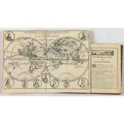
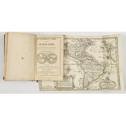
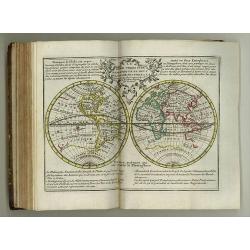
Introduction a la Geographie..
Second edition of this charming travel compendium illustrated with a fine world map in two hemispheres prepared by de l'Isle. California as an island. The hemispheres are...
- $2000 / ≈ €1762
Place & Date: Paris, 1717
Introduction a la Geographie..
Second edition of this charming travel compendium illustrated with a fine world map in two hemispheres prepared by de l'Isle. California as an island. The hemispheres are...
- $2000 / ≈ €1762
Place & Date: Paris, 1717
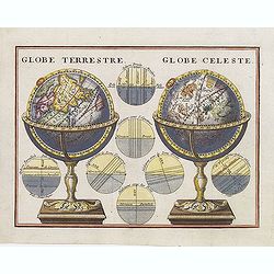
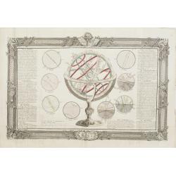
Globe Terrestre. / Globe Celeste.
A very decorative depiction of a terrestrial and celestial globe on a decorative base. The page is filled with seven diagrams.
- $175 / ≈ €154
Place & Date: Paris, 1719
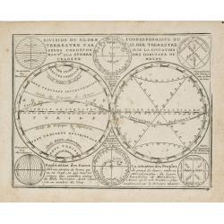
Division du Globe Terrestre par zones.. - Correspondance du Globe Terrestre avec la situation des habitants du monde.
A charming representation of various planetary models and systems according to the latest mathematical and scientific schemes of the day.From Le Nouveau et Curieux Atlas ...
Place & Date: Paris, 1719
Le Nouveau et Curieux Atlas Geographique et historique, ou Le Divertissement des Empereurs, Roys, et Princes. Tant dans la Guerre que dans la Paix. Dédié A Son A.R. Monseigneur le Duc d'Orléans Regent du Roîaume de France.
Charming world atlas with double hemisphere world and the North American map feature the Island of California. In Asia and the Pacific, Australia is incompletely mapped a...
Place & Date: Paris, 1719
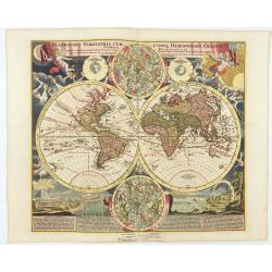
Planiglobii Terrestris Cum Utroq Hemisphaerio.
Vibrantly decorative world map surrounded by vivid engravings of natural phenomena such as waterspouts, a rainbow, earthquakes, and a volcano. Windheads occupy the starry...
Place & Date: Nuremberg, c. 1720
Premiere carte pour l'Introduction a l'histoire du monde, ou l'on remarque la Sphere, le Globe Celeste. . .
Featuring a small double hemisphere world map, showing California as an island, North and South Polar celestial hemispheres, an Armillary Sphere, below with smaller circu...
- $500 / ≈ €440
Place & Date: Amsterdam, 1720

Orbis terrarum typus de integro in plurimis emendatus auctus et icunculis illustratus.
Outstanding and rare example of a bible world map based on the Visscher bible map from 1657 (Shirley 401/414). This map is larger in size and has an extra engraved frame ...
- $2000 / ≈ €1762
Place & Date: Minden, 1729

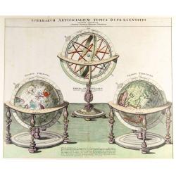
Sphaera Artificialium Typica repraesentatio.
Stunning engraving of terrestrial and celestial globes and armillary sphere, all with highly ornamented stands. Brief explanatory text. The plate was based on a design by...
Place & Date: Augsburg, 1730
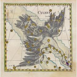
Cygnus.
Uncommon celestial print of Cygnus, published by Corbinianus Thomas in the Manuductio ad Astronomiam, Juxta modum Bayeri, Mathematici celeberrimi, concinnata, multis,…e...
- $350 / ≈ €308
Place & Date: Frankfurt & Leipzig, c.1730

Delphinus.
Uncommon celestial print showing the constellation of Delphinus, published by Corbinianus Thomas in the Manuductio ad Astronomiam, Juxta modum Bayeri, Mathematici celeber...
Place & Date: Frankfurt & Leipzig, c.1730

Sphaerarum Artificialium Typica Repraesentatio. . .
Johann Baptist Homann born in Kammlach (1663). He was engraver, map-seller and geographer to the Kaiser of the Holy Roman Empire (1715). He also was member of the Prussia...
- $1300 / ≈ €1145
Place & Date: Nuremberg 1740
Sphaerarum Artificialium Typica Repraesentatio. . .
Stunning engraving of Homann's terrestrial and celestial globes and armillary sphere, all with highly ornamented stands. Brief explanatory text.Johann Baptist Homann born...
Place & Date: Nuremberg, 1740
![[Title page] Atlas Coelestis in mundus spectabilis, et in eodem Stellarum](/uploads/cache/47437-250x250.jpg)
[Title page] Atlas Coelestis in mundus spectabilis, et in eodem Stellarum
Title page from the first edition of this celestial atlas.
Place & Date: Nuremberg 1742

Hemisphaerium Coeli Australe in quo Fixarum. . .
Magnificent celestial chart drawn by the famous scientist Johann Gabriel Doppelmayr.Large circular charts of the southern hemisphere constellation, with decorative vignet...
- $1800 / ≈ €1586
Place & Date: Nuremberg, 1747
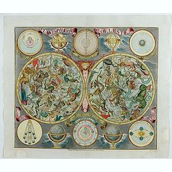
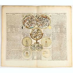
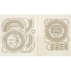
Planisphaerum coeleste.
A very decorative double hemisphere celestial chart. The 10 smaller circular diagram showing the rotation of the Planets, according to Tycho Brahe, Ptolemy and Copernicus...
Place & Date: Nurenberg, 1750
![[Double celestial and terrestrial hemisphere]](/uploads/cache/44995-250x250.jpg)
[Double celestial and terrestrial hemisphere]
Small but uncommon double celestial and terrestrial hemisphere. The terrestrial map showing the western hemisphere with an oversized an curious Australian continent.
- $300 / ≈ €264
Place & Date: ca. 1750

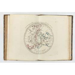
Introduction a la géographie carte des diverses positions de la sphere..
A charming and large print showing a terrestrial, celestial and an armillary globe with smaller circular diagrams illustrating the theories of Ptolemy, Copernicus, Brahe ...
- $1000 / ≈ €881
Place & Date: Paris 1750
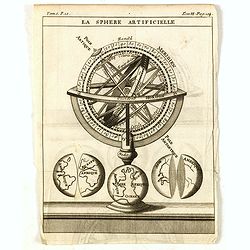
La Sphere Artificielle.
A diagram of an armillary sphere, with three illustrations of the Earth underneath. Published in "Nouveau traité de geographie par M**** ", published by La veu...
- $70 / ≈ €62
Place & Date: Paris, 1752

Mappemonde contenant les parties connues du globe terrestre dressée suivant de nouvelles observations
Wall map of the world in two hemispheres printed on two sheets, depicting the Eastern and Western hemispheres supported by two male figures, decorated at the bottom right...
Place & Date: Paris, Longchamps et Janvier, 1754
![[Lot of 2 prints of Globes] La Sphere Terrestre / La Sphere Celeste.](/uploads/cache/84233-250x250.jpg)
[Lot of 2 prints of Globes] La Sphere Terrestre / La Sphere Celeste.
La Sphere Terrestre / La Sphere Celeste A set of two very fine prints of a Terrestrial Sphere and a celestial Sphere. With an description on both sides. All within an ...
- $450 / ≈ €396
Place & Date: Paris, L.C. Desnos, 1761

Suite de l'Histoire de Perse. Depuis l'An 3519, jusqu'à l'An 3525.
Showing eastern Europe centered on Greece, Macedonia, Persia and western Turkey. Textural information in French flanking the map. De Mornas was Geographer to Louis XVI, a...
- $60 / ≈ €53
Place & Date: Paris, 1762

Atlas Geographicus portatilis XXIX mappis orbis habitabilis
Fine pocket atlas containing a world and celestial map, further maps of the four continents and of European countries. The map of America has a blank coastline north to C...
- $2750 / ≈ €2423
Place & Date: Augsburg 1762

Hemisphere Celeste Antarctique ou Austral. . .
Map printed in two colors, black for the stars, red for the constellation figures. With later color addition.Uncommon large-scale celestial chart of the southern hemisphe...
- $750 / ≈ €661
Place & Date: Paris, 1764
![Planisphere celeste Septentrional. . . [together with] Planisphere celeste meridional. . .](/uploads/cache/35291-250x250.jpg)
Planisphere celeste Septentrional. . . [together with] Planisphere celeste meridional. . .
Beautiful set of celestial charts of the northern and southern skies by the well-known French astronomer, Philippe de La Hire. Surrounded by panels of astronomical notes ...
Place & Date: Paris, ca.1775
![Schat-Kamer ofte konst der stuurlieden, behelzende een duidelyke onderwyzinge in de navigatie. . . [bound with] Tafelen bevattende De Sinussum, tangenten en Secanten. . . [bound with] Geographische Tadfel...](/uploads/cache/33112-250x250.jpg)
Schat-Kamer ofte konst der stuurlieden, behelzende een duidelyke onderwyzinge in de navigatie. . . [bound with] Tafelen bevattende De Sinussum, tangenten en Secanten. . . [bound with] Geographische Tadfel...
Schat-Kamer ofte konst der stuurlieden, behelzende een duidelyke onderwyzinge in de navigatie. . . [bound with] Tafelen bevattende De Sinussum, tangenten en Secanten. . ....
Place & Date: Amsterdam, J. v. Keulen en Zoonen, 1777
Nouvel atlas geographique & historique.. / Nieuwe en geographische en historische Atlas..
This second edition of this charming travel compendium is becoming relatively scarce nowadays.Illustrated with a charming frontispiece, two uncolored plates of a sphere, ...
Place & Date: Amsterdam, 1778

Représentation du Globe céleste En deux Plans Hémisphères Coupés par l'Ecliptique.
Scarce double armillary sphere prepared by Nolin and published by L.J. Mondhare for his Atlas Général a l'usage des colleges et maisons d'education.. Louis Joseph Mondh...
- $75 / ≈ €66
Place & Date: Paris, 1783

Divisions du Globe Terrestre en Cercles, Zônes, Climats, Longitudes et Latitudes.
A scarce print showing 15 globes, each globe showing different zones published by Mondhare for his Atlas Général a l'usage des colleges et maisons d'education.. Underne...
- $75 / ≈ €66
Place & Date: Paris, 1783
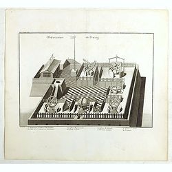
Observatoire de Peking.
The observatory of Mateo Rizzi in Peking, in which there are very large instruments, an Equinoctial Sphere, a Celestial Globe, a Zodiacal Sphere, Azimuthal Horizona, Quad...
- $200 / ≈ €176
Place & Date: Paris, GROSIER Jean-Baptiste, 1785
De la Sphère. L'equateur. Des Tropiques. Le zodiac. Les cercles polaires. L'Horizon. Le meridian.
Print of armillary sphere, surrounded by several diagrams of the sun, moon, and planets after Cassini. To the left and right 7 blocks of text with explanations and one co...
- $350 / ≈ €308
Place & Date: Paris, 1787
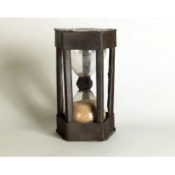
A ship's hour glass
The element common to celestial position-finding, the calculation of speed for dead reckoning and even everyday life at sea is the time: hence ways of determining and kee...
Place & Date: ca. 1790

Globe Terrestre. / Globe Celeste.
Showing a terrestrial and celestial spheres. Left and right a box with geographical information for spheres of different types.Prepared by Louis Brion de la Tour and publ...
- $400 / ≈ €352
Place & Date: Paris 1790
Atlas general A L'Usage Des Colleges Et Maisons..
Rare atlas, published by Mondhare, maps dated 1780,1781 and 1793. Usually bright, attractive copy for a work of this kind. As announced in its title, this work was specif...
- $6000 / ≈ €5286
Place & Date: Paris, 1791

Sterre kaert of hemels pleyn, waer door men kan wete hoe laet dat het is over de gehele aertkloot, op alle meridiane en polus hoogte . . .
A most attractive Mercator style oblong projection of the entire night sky showing all the heavenly bodies of the northern and southern skies, and with panels of astrolog...
Place & Date: Amsterdam, 1792
Two sheets for constructing an armillary sphere.
Two sheets for constructing an armillary sphere. Cassini was a geographer and cartographer, but also perspective and architecture carver - one of Giovanni Battista Pirane...
Place & Date: Rome, 1795
![Schat-Kamer ofte konst der stuurlieden, inhoudende Een duidelyke onderwyzinge in de navigatie. . . [bound with] Geographische Tadfel vande Graaden.. Voornaamste Zee-haavens. . .](/uploads/cache/33114-250x250.jpg)
Schat-Kamer ofte konst der stuurlieden, inhoudende Een duidelyke onderwyzinge in de navigatie. . . [bound with] Geographische Tadfel vande Graaden.. Voornaamste Zee-haavens. . .
Rare and important manual originally prepared by Klaas de Vries and improved by Evert Floryn and S.Hollander of the "Schat-Kamer ofte konst der stuurlieden" (Tr...
Place & Date: Amsterdam, Wed. Gerard Hulst van Keulen, 1802

Planisferio Celeste contenente le stelle dalla 1 alla 5 grandezza. . .
Decorative large double hemisphere celestial chart, centred on the north and south poles with descriptive key to zodiac signs in German, French and Italian. Showing stars...
- $1500 / ≈ €1321
Place & Date: Milan, c.1822
![[LXXXI. Amida e Xaca ].](/uploads/cache/34985-250x250.jpg)
[LXXXI. Amida e Xaca ].
Aquatint depicting Amida (or Amideva who is a celestial Buddha) and the God Xaca, engraved by A.Rancati. Plate N°81.From Giulio Ferrario's work Le Costume Ancien et Mode...
- $40 / ≈ €35
Place & Date: Milan, 1827
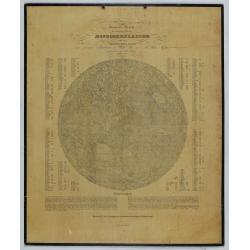
General-Karte der sichtbaren Seite der Mond-oberflaeche zugleich als Übersichts-Blatt zur grössern Mondkarte von Wilh. Beer und Joh: Heinr. Mädler.
An early representation of the viewable surface of the moon by Johann Heinrich Mädler (1794-1874) and Wilhelm Beer (1797-1850).Ignoring the occasional pre-telescopic ap...
Place & Date: Berlin, 1837
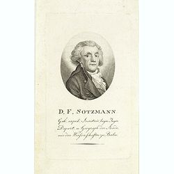
D.F. Sotzmann.
Portrait of Daniel Friedrich Sotzmann (1754 - 1840), engraved by F. Westermayr. Sotzman was a German cartographer and surveyor. He is considered the main initiator of the...
- $200 / ≈ €176
Place & Date: Berlin ? , ca. 1850
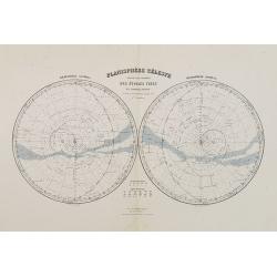
Planisphère Célèste.
Showing the southern and northern celestial hemispheres from Géographie Universelle, Atlas Migeon. Published by J. Migeon. From one of the last decorative atlases publis...
Place & Date: Paris, 1874
Selling price: $60
Sold in 2012
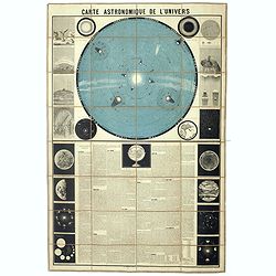
Carte Astronomique de L'Univers.
A large and decorative, informative chart illustrating and describing the Solar System, backed by the stars, printed in blue and black, surrounded by further 17 vignette ...
- $1100 / ≈ €969
Place & Date: Paris, 1875
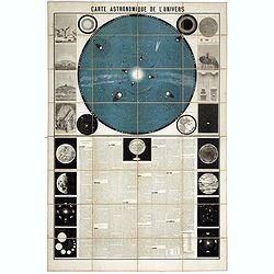
Carte Astronomique de L'Univers.
A large and decorative, informative chart illustrating and describing the Solar System, backed by the stars, printed in blue and black, surrounded by further 17 vignette ...
Place & Date: Paris, 1875
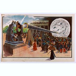
La Lune à un Mètre [Mini poster for Paris Exposition Universelle)
Original lithograph poster for "Paris Exposition Universelle" held between April and November, 1900, which received 50 million visitors. In 1899, director Geor...
Place & Date: Paris, c.1900
![[Set of six postcards] La Comète 1910 / Komet 1910.](/uploads/cache/44401-250x250.jpg)
[Set of six postcards] La Comète 1910 / Komet 1910.
Complete set of six postcards commemorating Halley's Comet in 1910. Numbered on verso 1 to 6, Verlag Koch & Bitriol Serie 3090 Bild 6 AK. Designed by K. Hesse. The ye...
Place & Date: Dresden, Koch & Britriol, 1910