Search Listings matching "blaeu"
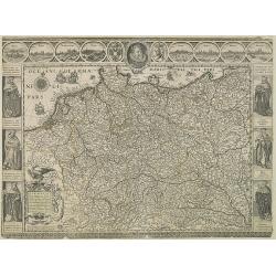
Germania.
Second state of this rare "carte à figures"- map of Germany, The Netherlands, Poland and central Europe. Bordered on three sides with portraits and views. In t...
Date: Amsterdam, 1607
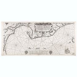
Pascaarte van een deel der Oost Zee, tusschen Bornholm ende der Memel, vertonende de ware gelegentheijt der Zeecusten van Pruijssen. . .
This very rare chart of the Northern Coast of Poland with Gdansk, appeared in the rare English edition of Willem Blaeu's 'Het Licht der Zeevaert', an atlas of sea charts ...
- $4000 / ≈ €3499
Date: Amsterdam, 1608

Domus Hansae Teutonicae / Sacri Romani Imperii. (Antwerp townhall)
From Ludovico Guicciardini.'s description of the Netherlands "Beschrijvinghe van alle de Nederlanden anderssins ghenoemt Neder-Duytslandt", published by Willem ...
Date: Amsterdam, 1612
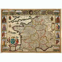
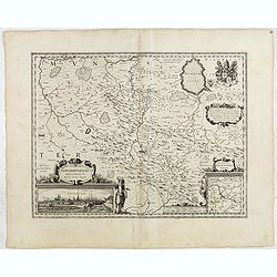
Gallia. Nova Galliae descriptio . . .
Very rare and early map of France with figures on three sides with views of cities, portraits (Henri IV and Marie de Medicis) and costumes. The map was directly influence...
Date: Amsterdam, 1616
!['T Derde deel van 't Licht der zee-vaert, inhoudende de beschryvinghe der zeecusten van de Middelandtsche Zee /, By een vergaedert ende in't licht ghebracht door Willem Janssen. [Blaeu sea atlas].](/uploads/cache/49048-250x250.jpg)
'T Derde deel van 't Licht der zee-vaert, inhoudende de beschryvinghe der zeecusten van de Middelandtsche Zee /, By een vergaedert ende in't licht ghebracht door Willem Janssen. [Blaeu sea atlas].
Extremely rare W. Blaeu's Sea Atlas describing the coasts and islands of the Mediterranean Sea, published in Amsterdam by W. Blaeu" Tot Amsterdam, by Willem Jansz. ...
- $150000 / ≈ €131211
Date: Amsterdam, 1618
Barbaria.
Small map illustrating the eastern part of the Mediterranean Basin, namely the African side. Surrounded by text in Dutch.Nicolaes de Clerck (de Klerc) was active as engra...
- $75 / ≈ €66
Date: Amsterdam, Cloppenburch, 1621

Tunetanum Regnum.
Small map representing Tunisia and Algeria, surrounded by text in Dutch.Nicolaes de Clerck (de Klerc) was active as engraver and publisher in Delft from 1599-1621.Include...
Date: Amsterdam, Cloppenburch, 1621
Malabar.
Small map illustrating the southwestern sea coast of India. Oriented with East on top, surrounded by text in Dutch.Included in the rare book : Wereld Spiegel, waer in ver...
- $200 / ≈ €175
Date: Amsterdam, Cloppenburch, 1621

Aegyptus.
A small map focused on the Nile Delta, where the Nile divides into several branches.Included in the rare book : Wereld Spiegel, waer in vertoontword de Beschryvinge der R...
Date: Amsterdam, Cloppenburch, 1621
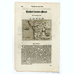
Congo Regnum Christian. In Africa.
Small map illustrating the western seashores of Central Africa, surrounded by text in Dutch.Nicolaes de Clerck (de Klerc) was active as engraver and publisher in Delft fr...
Date: Amsterdam, Cloppenburch, 1621

Tunetanum Regnum.
Small map representing Tunisia and Algeria, surrounded by text in Dutch.Nicolaes de Clerck (de Klerc) was active as engraver and publisher in Delft from 1599-1621.Include...
- $100 / ≈ €87
Date: Amsterdam, Cloppenburch, 1621
![Narsinga. [India]](/uploads/cache/38123-250x250.jpg)
Narsinga. [India]
Small map illustrating the Indian peninsular. Oriented with East on top, surrounded by text in Dutch.Nicolaes de Clerck (de Klerc) was active as engraver and publisher in...
Date: Amsterdam, Cloppenburch, 1621

Bengala.
Small map centered on the Bay of Bengal, surrounded by text in Dutch. Nicolaes de Clerck (de Klerc) was active as engraver and publisher in Delft from 1599-1621.Included ...
- $150 / ≈ €131
Date: Amsterdam, Cloppenburch, 1621

Malabar.
Small map illustrating the south western seacoast of India. Oriented with East on top, surrounded by text in Dutch.Nicolaes de Clerck (de Klerc) was active as engraver an...
Date: Amsterdam, Cloppenburch, 1621
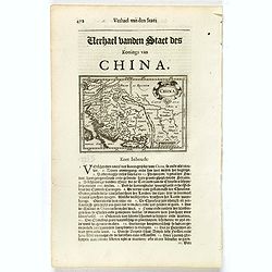
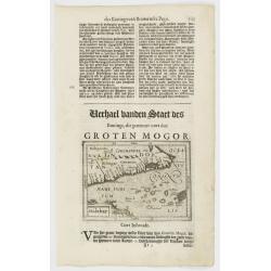
China.
Small map illustrating China with the Great Wall and Korea as an island, surrounded by text in Dutch.Nicolaes de Clerck (de Klerc) was active as engraver and publisher in...
- $200 / ≈ €175
Date: Amsterdam, Cloppenburch, 1621
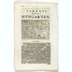
Hungaria.
Small map of Hungary, surrounded by text in Dutch. Nicolaes de Clerck (de Klerc) was active as engraver and publisher in Delft from 1599-1621.Included in the rare book : ...
- $100 / ≈ €87
Date: Amsterdam, Cloppenburch, 1621

Lotaringia Ducatus.
Small map of Lorraine, oriented with West on top and surrounded by text in Dutch. Nicolaes de Clerck (de Klerc) was active as an engraver and publisher in Delft from 1599...
- $75 / ≈ €66
Date: Amsterdam, Cloppenburch, 1621

Hispania.
Small map of the Iberian peninsula with the Balearic Islands, surrounded by text in Dutch.Nicolaes de Clerck (de Klerc) was active as an engraver and publisher in Delft f...
- $100 / ≈ €87
Date: Amsterdam, Cloppenburch, 1621

Gallia.
Small map of France, surrounded by text in Dutch. Nicolaes de Clerck (de Klerc) was active as engraver and publisher in Delft from 1599-1621.Included in the rare book : W...
- $70 / ≈ €61
Date: Amsterdam, Cloppenburch, 1621
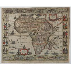
Africae nova Tabula.
A second state of this very rare "carte à figures"- map. Decorated with the four decorative borders by Jodocus Hondius Jr.This remarkable map of Africa was fir...
Date: Amsterdam, 1623
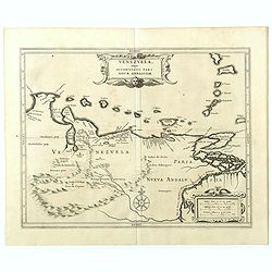
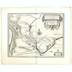
Venezuela, atque Occidentalis Pars Novæ Andalusiae.
The coastline of Venezuela with little interior development. Including Aruba, Bonaire, Curaçao, etc. This scarce map was prepared by Hessel Gerritsz (1581-1632), a forme...
- $600 / ≈ €525
Date: Leiden, 1625

Alpinae seu Foederatae Rhaetiae . . .
Extremely rare first edition of this beautiful map of Graubünden Canton in Switzerland. Including Chur, Davos, St.Moritz, etc.Jodocus Hondius Jr. planned to produce a ne...
- $750 / ≈ €656
Date: Amsterdam, 1629

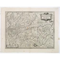
Sueviae Nova Tabula.
Extremely rare first edition of this beautiful map of Swaben, including Ulm, Augsburg, Stuttgart, Zurich, Lucerne and Lake Constance.Jodocus Hondius Jr. planned to produc...
Date: Amsterdam, 1629

Westphalia Ducatus.
1629 HONDIUS, J. - Extremely rare first edition of this beautiful map of Westphalia.
Date: Amsterdam, 1629
Monasteriensis Episcopatus.
The extremely rare first edition of this beautiful map of Munster.Jodocus Hondius Jr. planned to produce a new modern atlas less dependent on the Mercator plates that his...
Date: Amsterdam, 1629
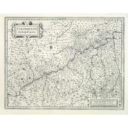
Coloniensis Archiepisscopatus.
Extremely rare first edition of this beautiful map of Cologne and Dusseldorff.Jodocus Hondius Jr. planned to produce a new modern atlas less dependent on the Mercator pla...
Date: Amsterdam, 1629

Tabula Islandiae. . .
With a very decorative cartouche and a very fine imprint. No text on verso; included in the rare "Appendix" of 1630. VERY RARE. This handsome map of Iceland was...
Date: Amsterdam, 1630

Venezuela, atque Occidentalis Pars Novæ Andalusiae.
Coastline of Venezuela with little interior development. Including Aruba, Bonaire, Curaçao, etc. Scarce map prepared by Hessel Gerritsz (1581-1632), former apprentice of...
- $600 / ≈ €525
Date: Leiden, Elzevier, 1630

Meklenburg Ducatus.
Very detailed map of the northern part of Germany decorated with a coat of arms, a windrose and two saling ships.From the rare atlas Appendix, published in a very small n...
Date: Amsterdam, 1629-1630

Oldenburg Comitatus
A map of the northern part of Germany centered on Oldenburg. Also showing Bremen. North to the right. The decoration consists with a windrose and a title cartouche surmou...
Date: Amsterdam, 1629-1630

Fossa quae a Rheno ad Mosam duci caepta est Anno CLC ICCXXVII.
FIRST STATE without the coats of arms and its final title "Fossa Sanctae Mariae." - Only included in a few early editions.Detailed map of part of the country be...
Date: Amsterdam, 1634

Wirtenberg Ducatus.
FIRST EDITION, FIRST ISSUE OF THIS MAP. From the 1634 edition of Blaeu's Atlas Novus, the first edition of this work. PROOF STATE with blank upper right corner, only incl...
Date: Amsterdam, 1634
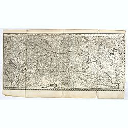
Tractus Danubii, Fluminis in Europa Maximi, A Fontibus, Per Germaniam. . .
This is Blaeu’s first map of the Danube and surrounding regions. The Danube River runs through the map from the top left with its headwaters in the German Black Forest ...
Date: Amsterdam, 1634
Osnabrugensis Episcopatus.
Originally engraved for Jodocus Hondius II, at his death in August 1629 this map was, among 39 other copper plates, purchased by Willem Blaeu who deleted Hondius' name an...
Date: Amsterdam, 1634

Waldeck Comitatus.
FIRST EDITION, FIRST ISSUE OF THIS MAP. From the 1634 edition of Blaeu's Atlas Novus, the first edition of this work.Important early map of Waldeck. Attractive coat of ar...
Date: Amsterdam, 1634

Franconia vulgo Franckenlandt.
FIRST EDITION, FIRST ISSUE OF THIS MAP. From the 1634 edition of Blaeu's Atlas Novus, the first edition of this work.Map highlights all the major cities of this region li...
Date: Amsterdam, 1634
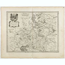
Hassia Landgraviatus.
FIRST EDITION, FIRST ISSUE OF THIS MAP. From the 1634 edition of Blaeu's Atlas Novus, the first edition of this work.Important map of Hesse in Germany, centered on the to...
Date: Amsterdam, 1634

Mansfeldia Comitatus. . .
FIRST EDITION, FIRST ISSUE OF THIS MAP. From the 1634 edition of Blaeu's Atlas Novus, the first edition of this work.Centered on Mansfeld and its surrounding region, this...
Date: Amsterdam,1634

Nassovia comitatus.
Elegantly engraved map of the region including Koblenz, Sigen and Dillenburg. The mountainous topography is graphically depicted and there is a coats of arms in the corne...
Date: Amsterdam, 1634

Mantua ducatus.
Originally engraved for Jodocus Hondius II, at his death in August 1629 this map was, among 39 other copper plates, purchased by Willem Blaeu who deleted Hondius' name an...
Date: Amsterdam, 1634
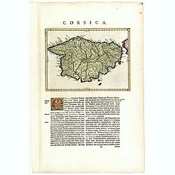
Corsica.
FIRST EDITION, FIRST ISSUE OF THIS MAP. Blaeu's map of the French island of Corsica. East on top. A detailed and well executed map.From an incomplete example of the 1634 ...
- $500 / ≈ €437
Date: Amsterdam, 1634

Sardinia Insula.
FIRST EDITION, FIRST ISSUE OF THIS MAP. Map of the Italian island of Sardinia in a copper engraving on a sheet with letterpress with German text description of the island...
Date: Amsterdam, 1634
Paraguay o Prov. de Rio de la Plata cum regionibus adiacentibus Tucuman et Sta. Cruz de la Sierra.
Blaeu's map of the Rio de la Plata region of South America. Originally engraved for Jodocus Hondius II, at his death in August 1629 this map was, among 39 other copper pl...
Date: Amsterdam, 1634

Helvetia cum finitimis regionibus confoederatis.
Detailed and finely engraved map of Switzerland with a pair of fine cartouches.From early on Willem Jansz. Blaeu aimed of publishing an atlas to compete with the Hondius-...
Date: Amsterdam, 1634

Das Wiflispurgergow.
Detailed map of South-western Switzerland after Gerhard Mercator's map of the same. With ornamental title cartouche and German text on the verso.It shows Geneva, Lake Gen...
Date: Amsterdam, 1634

Argow cum parte merid. Zurichgow.
Nice map of Canton Aargau and parts of the Cantons Schwyz, Zürich and Glarus. Includes the cities of Bern and Luzern.Based on the cartography of Gerard Mercator and very...
Date: Amsterdam, 1634

De Hertochdommen Gulick Cleve Berghe en de Graefschappen...
It is one of Blaeu's early maps: It was only published between 1630 and 1635 in three editions of the "Appendix" and one of the "Theatrum". In the lef...
Date: Amsterdam, 1635
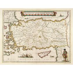
Natolia, quae olim Asia minor.
A finely designed map of Turkey and Cyprus from the great Blaeu family of Amsterdam. The decoration consist of a colored title cartouche, sea monsters, a naval engagement...
Date: Amsterdam, 1635

Insulae Americanae in Oceano Septentrionali cum Terris adiacentibus.
General map of the West Indies extending from Virginia to the mouth of the Orinoco, and destined to be copied in various shapes by many other publishers. Title cartouche ...
- $1000 / ≈ €875
Date: Amsterdam, 1635

Franconia vulgo Franckenlandt.
Fine copy centered on Bamberg, Nuremberg, Würzburg, and Nuremberg. French text on verso. Würzburg is the main city in Franconian wine country. Grapevines cover the stee...
Date: Amsterdam, 1635
![[Lot of 14 maps of Germany] Nova Totius Germaniae Descriptio.](/uploads/cache/19045-(3)-250x250.jpg)
[Lot of 14 maps of Germany] Nova Totius Germaniae Descriptio.
Willem Blaeu, founder of the famous publishing firm. Originally publishing pilot-guides, he issued his first atlas, 'Atlantis Appendix', in 1630, followed by his "...
- $500 / ≈ €437
Date: 1635
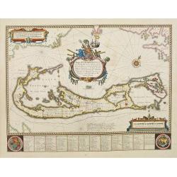
Mappa Aestivarum Insularum alias Barmudas.
Blaeu based his work on John Speed's remarkably accurate map of 1626-1627. It shows the island divided into tribes and lots, and below the map itself appear the names of ...
Date: Amsterdam, 1635

Nouvelle et exacte Carte du Duche de Brabant. . .
A very rare example of a map of the Duchy of Brabant. Title cartouche in the lower left-hand corner. A very rare issue of this map of Brabant. Cornelis Danckerts II. copi...
Date: Amsterdam, 1635
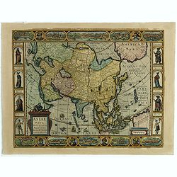
Asiae Nova Descriptio.
Final State of Pieter Van Den Keere's Rare Map of Asia--The first map of Asia to include decorative panels.The map has an interesting south positioning of the Caspian Sea...
Date: Amsterdam, 1636
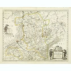
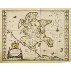
Ducatus Limburg.
A very rare issue of this map of Limburg. Cornelis Danckerts II copied the folio map of H.Hondius.The publisher's address was placed in the lower right-hand corner. The c...
Date: Amsterdam, 1636

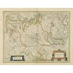
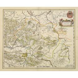
Comitatus Marchia et Ravensberg.
With an inset of Ravensberg comitatus. Decorative title cartouche with coats of arms. Scale cartouche with a surveyor.As Willem Blaeu died in 1638 most of his maps are ac...
Date: Amsterdam, 1638

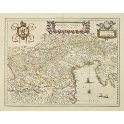
China Veteribus Sinarum Regio nunc Incolis Tame dicta.
Fine map of China, based on the first of Blaeu's maps of China. In the west by the Great Wall is shown, among Taiwan is named Pakan al I. Formosa, although Tayoan is name...
Date: Frankfurt am Main, 1638

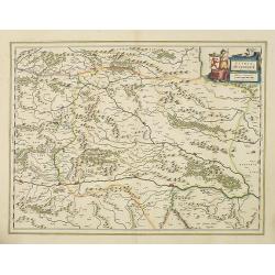
Saltzburg Archiepiscopatus, et Carinthia Ducatus
Handsome map of the archbishopric of Salzburg and the Duchy of Carinthia.Title in banner form with two coats of arms and three cherubs decorating the map.As Willem Blaeu ...
Date: Amsterdam, 1638
Taurica Chersonesus, Nostra aetate Przecopsca, et Gazara dicitur.
Part of Russia with in the north Smolensk and Moscow and in the south the Black Sea.As Willem Blaeu died in 1638 most of his maps are actually published by his son Joan. ...
Date: Amsterdam, 1638
Stiria Steyermarck.
Covering the eastern part of Austria, Styria and Carinthia, centered on the town of Graz.As Willem Blaeu died in 1638 most of his maps are actually published by his son J...
Date: Amsterdam, 1638
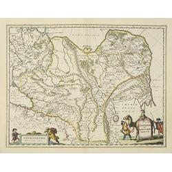
Walachia, Servia, Bulgaria, Romania.
Striking map of the region centered on the Lower Danube, Bulgaria, Romania, Serbia and Macedonia. Includes decorative cartouche, coat of arms, etc. Latin text on verso.Th...
Date: Amsterdam, 1638
Karstia, Camiola, Histria et Windorum Marchia.
Including the Gulf of Trieste, Venice and the northern part of former Yugoslavia. Prepared by Gerard Mercator.As Willem Blaeu died in 1638 most of his maps are actually p...
Date: Amsterdam, 1638
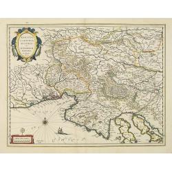
Dominio Veneto nell' Italia.
With the Gulf of Venice. Including the towns of Cremona, Brescia, Venice, etc.As Willem Blaeu died in 1638 most of his maps are actually published by his son Joan. This m...
Date: Amsterdam, 1638

Mantua ducatus.
Centered at the town of Mantua.As Willem Blaeu died in 1638 most of his maps are actually published by his son Joan. This map carries his (engraved) signature and was act...
Date: Amsterdam, 1638
Mediolanum Ducatus.
Very fine map centered on Milan Including Lake Como, Lake Garda, Lake Majore, Parma, etc.As Willem Blaeu died in 1638 most of his maps are actually published by his son J...
Date: Amsterdam, 1638

Regno di Napoli.
To the left and right 12 coats of arms of different regions.As Willem Blaeu died in 1638 most of his maps are actually published by his son Joan. This map was actually pu...
Date: Amsterdam, 1638
Tartaria sive Magni Chami imperium.
Detailed and decorative map of Tartary and Northern part of China. Northern tip of Korea included. The Chinese Great Wall is depicted, with Central Asia, extending from M...
Date: Amsterdam, 1638
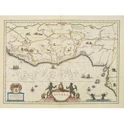
Guinea.
An attractive map covered with intersecting rhumb lines and decorated with monkeys, lions, elephants and native figures. With a dedication to Dr. Nicolas Tulp.As Willem B...
Date: Amsterdam, 1638

Insulae Americanae in Oceano Septentrionali cum Terris adiacentibus.
General map of the West Indies extending from Virginia to the mouth of the Orinoco, and destined to be copied in various shapes by many other publishers.Title cartouche t...
Date: Amsterdam, 1638
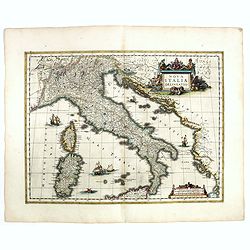
Nova Italiae delineatio.
Originally engraved for Jodocus Hondius II, at his death in August 1629 this map was, among other copper plates,purchased by Willem Blaeu who trimmed the figured borders,...
Date: Amsterdam, 1638
Rugia Insula ac ducatus. . .
Willem Blaeu's highly decorative map of the island of Rugen in the Baltic Sea from a map by Eihard Lubin. Embellished with a title-cartouches, and 30 coats-of-arms in the...
- $300 / ≈ €262
Date: Amsterdam, 1638

Saxonia Superior, cum Lusatia et Misnia.
Finely engraved and detailed map of Saxony including Halle, Leipzig, Meissen, and Dresden. Filled with forests and tiny villages. It presents Prague close to the centre o...
Date: Amsterdam, 1638
Mansfeldia Comitatus. . .
Centered on Mansfield and prepared by Telemann Stella (1527-1589) a German cartographer who made maps of Germany and the Holy Land.As Willem Blaeu died in 1638 most of hi...
Date: Amsterdam, 1638

Monasteriensis Episcopatus.
A very detailed map of Germany centered on Munster and Linge. Also showing Wessel to the top of the map and Oldenburg to the right. North to the right. The map is adorned...
Date: Amsterdam, 1638

Bravnswyck et Meydburg. . .
As Willem Blaeu died in 1638 most of his maps are actually published by his son Joan. This maps carries his (engraved) signature and was actually published in volume II o...
Date: Amsterdam, 1638

Westphalia Ducatus.
Elegantly engraved map of Westphalia including Hamm and Lippstadt. The mountainous topography is graphically depicted and several small coats of arms dot the map. Strapwo...
Date: Amsterdam, 1638
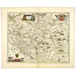
Polonia regnum et Silesia ducatus.
Very decorative map of Poland embellished with two cartouches and two coats of arms surmounted by cherubs and female figures. Showing the region from the Oder east to Pod...
Date: Amsterdam, 1638

Osnabrugensis episcopatus.
A beautiful map of Munster centered on the city of Osnabruck. Prepared by Joannes Michael Gigas (1580-1650+), a doctor, mathematician and geographer. Showing an inset wit...
Date: Amsterdam, 1638

Dominio Veneto nell' Italia.
Blaeu's map of the Dominion of Venice. This influential map is adorned by a cartouche of the city of Venice, a winged Lion, a title cartouche of putti and an entwined rib...
Date: Amsterdam, 1635-1638
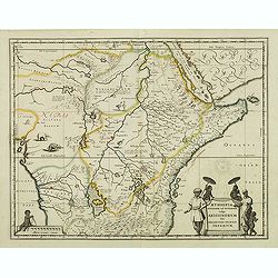
Aethiopia Superior vel Interior vulgo Abissinorum.
An attractive map of Eastern Africa and the fictitious kingdom of Prester John. The map shows a major section of central and eastern Africa including Mozambique north to ...
Date: Amsterdam, 1638
