Search Listings matching "Beautemps-Beaupré"

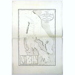
Carte Generale des Cotes de la Cochinchine et du Camboge.
A large, double-page French sea chart of part of the southern Cambodian coastline, and from Vietnamese Saigon up to Vung-Tau, Cap Varella, Cam Ranh Bay and Nha Trang. Wit...
- $1000 / ≈ €881
Place & Date: Paris, 1780
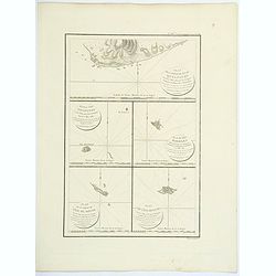
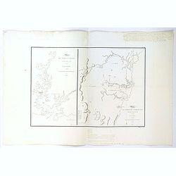
Plan de la partie de l'ile de quelpaert. . . / Plan de l'ile Hoapinsu. . . / Plan de l'ile Dagelet. . . / Plan de la partie de l'ile de Botol. . . / Plan de l'ile de Kumi. . .
Five plans on a folio sheet. These charts include Cheju Do, Korea (Quelpaert Is.), Kume-Shiwa, Okinawa (Kumi), and Ullung Do (Dagelet).Including one of the earliest maps ...
- $750 / ≈ €661
Place & Date: Paris, 1797
Plan de la Baie de L'Adventure. . .
A French maritime chart of Adventure Bay in S.E. Tasmania. Adventure Bay is the name of both a township and a geographical feature on the eastern side of Bruny Island. Th...
Place & Date: Paris, ca 1807
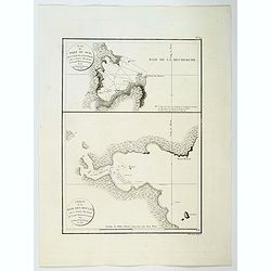
Plan du Port du Sud de la Baie de la Recherche / Croquis de la Baie des Moules. . .
A French maritime charts of the Port du Sud in Research Bay and the mouth of the Bay of Mussels, both in southern Tasmania. This is the edition of the extremely rare atla...
Place & Date: Paris, ca 1807
Plan du Port du Nord de la Baie de la Recherche.
A French maritime chart of the plan of the northern portion of Recherche Bay on the S.E. tip of Tasmania. The chart has some physical detail, outlining trees and hills, b...
Place & Date: Paris, ca 1807
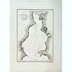
Plan du Port Jackson / Plan du Comte de Cumberland.
Two maps on one sheet showing the earliest scientific surveys of Port Jackson and the area surrounding Sydney Harbour, undertaken by the French in 1802. This is the editi...
Place & Date: Paris, 1807
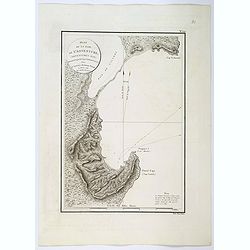
Carte de la Baie des Chiens-Marins (Shark's Bay de Dampier). . .
A strikingly detailed chart of a portion of the coastline of Western Australia, titled 'Carte de la Baie des Chiens-Marins, which was also explored by William Dampier. Th...
Place & Date: Paris, 1807
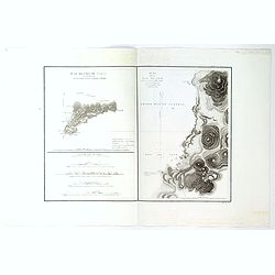
Plan de L'Isle de Paque / Plan de la Baie de Cook.
Two engraved maps and four coastal profiles of Easter Island in the Pacific. First published in the Atlas du Voyage de la Perouse. This is the edition of the extremely ra...
Place & Date: Paris, 1797-1807
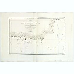
Carte de L'Archipel de La Recherche a la partie Occidentale de la Terre de Nuyts. . .
A large and detailed chart of the southern West Australian coast centered on the region of Esperance and the surrounding islands.Terre de Nuyts is the name that was forme...
Place & Date: Paris 1807

Beautemps-Beaupré (Charles-François).
Portrait of Charles-François Beautemps-Beaupré, engraved by Boilly.Charles-François Beautemps-Beaupré (6 August 1766 in La Neuville-au-Pont – 16 March 1854 in Paris...
Place & Date: Paris, 1822

Neptune des Côtes Occidentales de France.
Large maritime atlas illustrated with a handwritten title, a table and 47 single or double page charts. The charts show the western coasts of France as well as the Spanis...
- $12000 / ≈ €10571
Place & Date: Paris, 1776-1822

Carte Particuliere de la Cote de Cochinchine Depuis le cap Saint Jacques jusqu'au Faux Cap Varelle.
This is an impressive 1830 example of the French Depot-General de la Marine nautical chart or maritime chart of the southern coast of Vietnam. The chart extends from Saig...
- $1000 / ≈ €881
Place & Date: Paris, 1830

Plan de la Riviere de Saigon depuis le cap St. Jacques jusqu'a la Ville de Saigon.
A chart showing the twists and turns of the Saigon River between Saigon and Cap St. Jacques, produced and published by the Depot General de la Marine in Paris. During 14t...
- $750 / ≈ €661
Place & Date: Paris, ca 1830

Port de Touran. . .
A large sea chart produced and published by the Depot General de la Marine in Paris. It shows the Port of Touran (modern day Da Nang) in Vietnam. Located on the coast of ...
- $500 / ≈ €440
Place & Date: Paris, ca 1830