Search Listings matching "arrowsmith" in Europe
A Map of the Environs of Constantinople Drawn from a great number of accurate astronomical & geographical manuscripts and printed documents, by A. Arrowsmith 1801 and 1804.
Arrowsmith’s large and detailed map of the Ottoman Empire and the Black Sea, with Cyprus, Crete and the Greek Islands in the Mediterranean Sea, Albania, Bosnia and Herz...
Place & Date: London, No.10 Soho Square, 4th September 1804

The Inland Navigation, Rail Roads, Geology and Minerals of England & Wales.
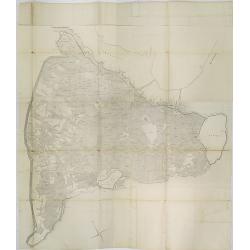
A beautifully color-coded and robustly labelled map describes the geology of England and Wales. The colors indicate particular rock materials in accordance with a key at ...
Place & Date: London, 1834

England.
A large and detailed steel engraved map of England, with each county divided by a different color. Many place names and physical features shown - it shows how densely pop...
Place & Date: London, 1839

Scotland.
An attractive steel engraved map of Scotland, with each county divided by a different color. Many place names and physical features shown.The Arrowsmith family members we...
Place & Date: London, 1839

Sweden & Norway.
An attractive steel engraved map of Sweden & Norway. An inset map which is the continuation from Tornea to North Cape. Many place names and physical features shown.Th...
Place & Date: London, 1839

Holland & Belgium.
An attractive steel engraved map of Holland and Belgium. Map flanked by France and Prussia. Duchy of Luxembourg included. Many place names and physical features shown. 4 ...
Place & Date: London, 1839
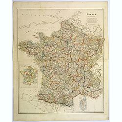
France.
A lovely, large steel engraved map of France, with an inset sketch of France divided into provinces, plus small inset map of the French Mediterranean island of Corsica . ...
Place & Date: London, 1839
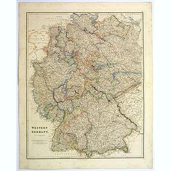
Western Germany.
A lovely, large steel engraved map of Western Germany. Some of the states engraved are: Holstein, Hannover, Mecklenburg, Saxony, Bavaria, Württemberg and Nassau. An extr...
Place & Date: London, 1839

Prussia & Poland.
A glorious, large steel engraved map of Prussia and Poland. Some of the states covered are: Saxony, Pomerania, Posen, Brandenburg, Western & Eastern Prussia and the K...
Place & Date: London, 1839
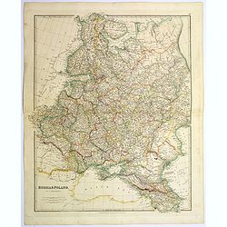
Russia & Poland.
A glorious, large steel engraved map of Russia and Poland. Covering Poland and Finland in the west, as far south as to the very edges of Persia, the Black sea, and to the...
Place & Date: London, 1839
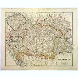
Austrian Empire.
A, large steel engraved map of the mighty Austrian Empire, covering Austria, Dalmatia, Styria, Slavonia, Hungary, Transylvania, Moravia and Bohemia. An enormous amount of...
Place & Date: London, 1839

Greece and the Ionian Islands.
A large steel engraved map concentrating on Greece and the Ionian islands. Featured are Albania, Corfu, Macedonia, Central Greece and Morea., along with many small island...
Place & Date: London, 1839

Spain & Portugal.
A large steel engraved map of European neighbours of Spain and Portugal. Including Balearic Islands, with a further inset map of Minorca. Numerous place names and physica...
Place & Date: London, 1839