Browse Listings in East Meets West > General
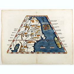
Tabula Superioris Indiae & Tartariae maioris. (Modern Map of China, Japan, etc.)
Important map extending from Tartary in the north, to "Prov. Bocat" (Cambodia) in the south. "Tebet" is shown prominently, as is "Zinpangri"...
Place & Date: Vienne, 1541
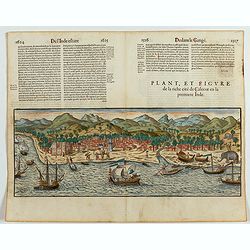
Plan, et figure de la riche cité de Calecut en la premiere Inde.
A rare and early woodcut view of Calcutta in India. Decorated with several ships on the sea, shipbuilding, fishermen and elephants.This woodcut was published in La Cosmog...
Place & Date: Paris, 1575
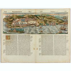
Goa fortissima Indiae urbs in Christianorum potestatem anno Salutis 1509. devenit.
A rare and early woodcut view of Goa in India. Decorated with one ship. This woodcut was published in La Cosmographie Universelle de tout le monde, printed 1575 in two vo...
Place & Date: Paris, 1575
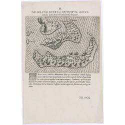
Delineatio Duorum Oppidorum, Ortat.
Early map of the Banda Islands.Theodore de Bry, a German engraver and book dealer, began a compilation of early voyages in 1590 and had published six parts at the time of...
Place & Date: Frankfurt, 1609

Delineatio Civitatis et Castelli Amboinae.
Early view of Ambon, with 6 Dutch vessels offshore.Theodore de Bry, a German engraver and book dealer, began a compilation of early voyages in 1590 and had published six ...
Place & Date: Frankfurt, 1609
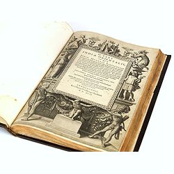
II Pars Indiae Orientalis in qua Johan. Hugonis Linschotani. . .
De Bry's Part II of his "Les Petit Voyages", containing "Pars Indiae Orientalis, in qua Johan. Hugonis Linscotani navagatio in Orientem, 1609", being ...
Place & Date: Frankfurt, Wolffgang Richter, 1609
![[Dutch ship Amsterdam].](/uploads/cache/37948-250x250.jpg)
[Dutch ship Amsterdam].
Text engraving of the Dutch vessel Amsterdam offshore the island of Java near Surabaya from "Premier livre de l'histoire de la navigation aux Indes Orientales, par l...
- $150 / ≈ €132
Place & Date: Amsterdam, Cornille Nicolas, 1609
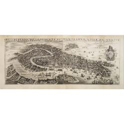
Desciption de lopulente et manifique ville de Venise.
Extremely rare panoramic view of Venice and neighboring islands (Murano, Burano, Torcello and Mazorbo), clearly depicting the city's architectural landmark. The surroundi...
Place & Date: Paris, 1646
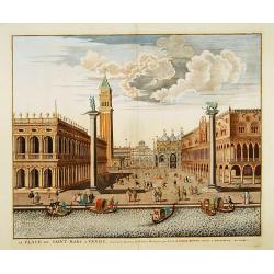
La Place de Saint Marc a Venise.
A very attractive Town plan of the place St Marc in Venice.Joan Blaeu published during his life three town books of Italy: Citta del Vaticano, Rome, and Napoli. By the ye...
Place & Date: Amsterdam, 1705
Platte Grond vande Stadt Macao.
A fine view of the city of Macao from Lappa Island showing in schematic blocks the structure of the town. With European vessels and junks in the surrounding water. With n...
- $750 / ≈ €660
Place & Date: Amsterdam, 1724

Nieuwe kaart van Arabia.
An attractive map of the Arabian Peninsula here is called Gelukkig Arabia or Happy Arabia . The map has a great advance on other maps of the time by showing the true exte...
Place & Date: Amsterdam, 1740
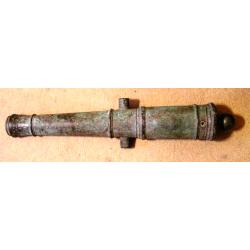
A fine bronze cannon.
Cannon built up of two truncated conusses, differing in size, the steps marked by mouldings shaped as flat bands preceded by ogees: base ring similar; breech with ogee-sh...
Place & Date: Amsterdam, ca. 1755
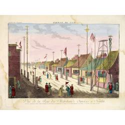
Vue de la Rue des Marchands Chinoises a Nankin.
So-called optical print illustrating a parade of vessels. Engraved by F.X. Habermann (1721-1796). The Academie Imperiale was a well-known publisher of optical prints, est...
- $450 / ≈ €396
Place & Date: Augsburg, 1760
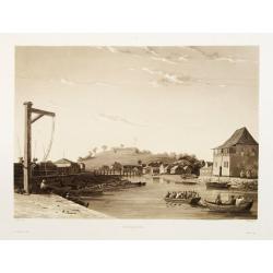
Sincapour.
Early view of Singapore after Paris and engraved in aquatint technique by Sigismond Himely (1801-1872). Published as plate 28 in Voyage autour du monde par les mers de l'...
Place & Date: Paris, Finot, 1835
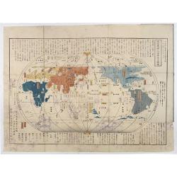
Chikyu Bankoku sankai yochi zenzu setsu. / Sekisui Cho Harutaka. (Map and description of geography of all the countries of the globe).
Reduced version of the famous map "Kaisei chikyu bankoku zenzu" by Sekisui Nagakubo (1717-1801) published ca. 1785, still based on the one by Matteo Ricci. Incl...
- $3500 / ≈ €3082
Place & Date: Tokyo, 1850
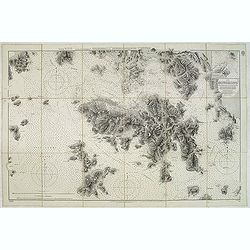
COLLECTION OF HONG KONG MAPS, BOOKS & FLYERS. Including CHINA - HONGKONG surveyed by Captn. Sir Edward Belcher, in H.M.S. Sulphur 1841. Corrected to 1901.
A collection of 30 maps, prints, and publications relating to Hong Kong. Including : - BELCHER, E. Sir, An updated version of this most important nautical chart of Hong K...
Place & Date: London, 1841 - 1901