Search Listings matching "uzbekistan" in East Meets West
![Septima Asie Tabvla. |Walsseemüller's map of Central Asia and the Silk Road]](/uploads/cache/62137-250x250.jpg)
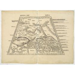
Septima Asie Tabvla. |Walsseemüller's map of Central Asia and the Silk Road]
Trapezoidal woodcut map showing the area east of the Sarygamysh Lake, about midway between the Caspian Sea and the (former) Aral Sea. It is one of the earliest obtainabl...
Place & Date: Strasburg, J. Schott, 1513
Septima Asie Tabula (Central Asia.)
A woodblock-printed large-format Ptolemaic map showing the region east of the Caspian Sea is labeled SOGDIANA. Sogdia or Sogdiana was an ancient Iranian civilization betw...
Place & Date: Strasburg, 1513
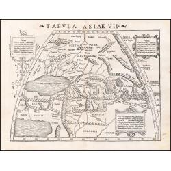
Tabula Asiae VII.
Attractive woodblock map, depicting the Caspian Sea, Black Sea and the Persian Gulf, extending to the Imaus Mountains. according to Ptolemy. In the center of the map is...
- $500 / ≈ €440
Place & Date: Basle, 1542
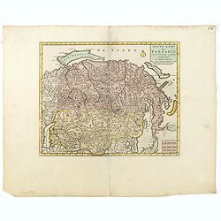
Tartaria sive Magni Chami imperium.
This is a detailed and decorative map of the Tartary and northern part of China, including the Chinese Great Wall, the Caspian Sea, and the Volga River east as far as the...
- $700 / ≈ €617
Place & Date: Amsterdam, 1658

A New Map of Great Tartary and China with the adjoining parts of Asia
Two insets show the land to the northeast of China, according to Jesuit information. The map stretches from northern Russia and Nova Zemlya in the northwest to Formosa in...
Place & Date: Oxford, 1700
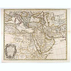
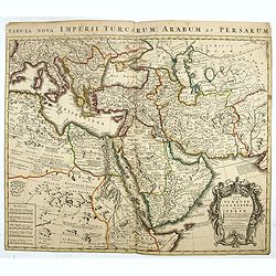
A Map of Turky, Arabia And Persia. Corrected from the latest Travels. . .
FIRST EDITION - Fine Turkish Empire map centered on Saudi Arabia, Cyprus and the Mediterranean Sea. Dated 1711, "Sold by John Senex at the Globe aga inst St. Dunstan...
- $1750 / ≈ €1542
Place & Date: London, 1721
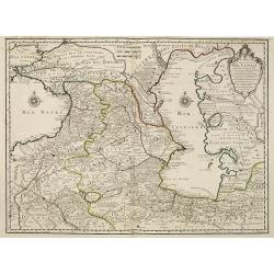
Carte des Pays Voisins de la Mer Caspiene dressee pour l' usage du Roy. . .
The map shows the area east of the Caspian Sea, including parts of Kazakhstan, Turkmenistan, Uzbekistan, and northern Iran. The area eastward from the Caspian is marked '...
- $750 / ≈ €661
Place & Date: Paris, 1723
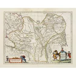
Nova Maris Caspii et Regionis Usbeck cum Provincijs adjacentibus vera Delineatio
This is the first printed map specifically of the Uzbek region. The map shows the area around the Caspian Sea and northern Iran. The earea eastwards from the Caspian is m...
Place & Date: Nuremberg, 1735
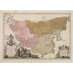
Carte la plus generale et qui comprend la Chine, la Tartarie chinoise et le Thibet. . .
It has a quite elaborate pictorial cartouche engraved by G. Kondet. It is a very detailed map of China, Tibet, and Korea.In the upper left corner is very good details of ...
Place & Date: The Hague, 1737
Nieuwe kaart van Tartarie.
A map of Tartary, Korea and part of Japan. The map is most notable for the confusion between Kamchatka and Iesso.There are very good details of towns and trade routes in ...
Place & Date: Amsterdam, 1750
Carte de la Turquie de L'Arabie et de la Perse.
This is the Amsterdam issue of De L'Isle's map of the Turkish Empire and Arabian Peninsula. It includes the Turkish Empire, the Mediterranean, Central Asia, and parts of ...
Place & Date: Amsterdam, 1751

Spatiosissimum Imperium Russiae Magnae juxta recentissimas Observationes Mappa Geographica . . .
This is a decorative map of greater Russia, extending from Livonia in the west to Kamchatka, China, Tibet, Taiwan, Korea, and part of Japan in the east. To the south, it ...
- $1300 / ≈ €1145
Place & Date: Augsburg, 1757
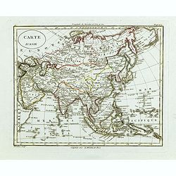
Carte d'Asie.
Fine map of Asia, with an interesting representation of Japan, Hokkaido, Sakhalin Island, Kamchatka, and Korea. Engraved by Alexandre Blondeau, who also worked for Depôt...
- $175 / ≈ €154
Place & Date: Paris, c. 1810
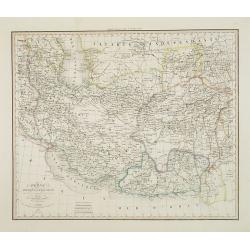
Perse Afghanistan et Balouchistan . . .
Detailed map of Irak and Iran, prepared by A. H. Basset, rue Saint-Jacques, no. 64, Paris and published in Atlas classique et Universel de Géographie . . . .The top thre...
Place & Date: Paris, A.H. Basset, 1828

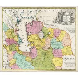
Carte physique et politique de l'Asie. Publiée pour la première fois en 1822 par J. GOUJON. Revue et augmentée par l'éditeur d'après de nouveaux matériaux.
This is a detailed map of Asie. It provides very good details of towns in modern-day Uzbekistan. The region is labeled as "Usbecs." The important cities on the...
- $500 / ≈ €440
Place & Date: Paris, J. Goujon et J. Andriveau, 1837

Orbis Veteribus Notus.
This is a detailed steel-engraved map of the ancient world, stretching from Europe eastwards to the Black Sea and beyond, southwards through northern Africa, Arabia, Indi...
Place & Date: London, 1839