Browse Listings in America

Town of Cortlandt.
Fine lithographed map of the town of Cortlandt. The map provides the names of specific homeowners, as well as information about the occupations and physical locations of ...
- $90 / ≈ €84
Place & Date: New York, 1867

Town of Verplanck / Crugers / Croton Landing.
Fine lithographed map of the town of Verplanck / Crugers / Croton Landing. The map provides the names of specific homeowners, as well as information about the occupations...
- $90 / ≈ €84
Place & Date: New York, 1867
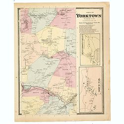
Town of Yorktown.
Fine lithographed map of the town of Yorktown. The map provides the names of specific homeowners, as well as information about the occupations and physical locations of t...
- $90 / ≈ €84
Place & Date: New York, 1867

Town of Somers.
Fine lithographed map of the town of Somers. The map provides the names of specific homeowners, as well as information about the occupations and physical locations of the...
- $90 / ≈ €84
Place & Date: New York, 1867

Town of North Salem.
Fine lithographed map of the town of North Salem. The map provides the names of specific homeowners, as well as information about the occupations and physical locations o...
- $90 / ≈ €84
Place & Date: New York, 1867
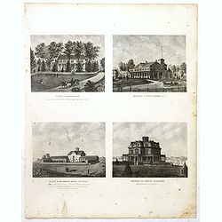
Property of F.A.Halstead Bedford Station, The Halstead Homestead at Bedford and Inland Vale residence of J.S.Libby, Westchester Co. NY North Salem.
Three heliographic prints on one sheet : "Property of F.A.Halstead Bedford Station", "The Halstead Homestead at Bedford" and "Inland Vale residen...
- $100 / ≈ €94
Place & Date: New York, 1867
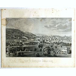
View of Brewsters' Putnam Co.N.Y.
Heliographic print of Brewsters' Putnam Co.N.Y." after a design by R.K.Sneden.From Beer's famous county atlas "Atlas of New York and vicinity, a documentary rec...
- $100 / ≈ €94
Place & Date: New York,1867
Résidence of WM H.Drew Southeast Putnam Co.N.Y / Lake Farm Résidence of John V.Storm East Fiskill Dutches Co.N.Y.
Two heliographic prints on one sheet : " Résidence of WM H.Drew Southeast Putnam Co.N.Y / Lake Farm Résidence of John V.Storm East Fiskill Dutches Co.N.Y." af...
- $100 / ≈ €94
Place & Date: New York,1867
Todd Homestead / Résidence of B. Travis Katonah N.Y / Reisig & HexamersBarn Ivy Hill / Résidence of W.F Bearns
Four heliographic prints on one sheet : "Todd Homestead / Résidence of B. Travis Katonah N.Y / Reisig & HexamersBarn Ivy Hill / Résidence of W.F Bearns "I...
- $100 / ≈ €94
Place & Date: New York,1867
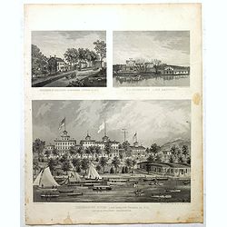
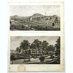
Residence of A.S. Doane Doanesburg Putnam Co. N.Y. - N. L. Thompsons's lake Mahopac - The Gregory House lake Mahopac Putnam Co N. Y. Lewis H. Gregory Proprietor.
Three heliographic prints on one sheet : "Residence of A.S. Doane Doanesburg Putnam Co. N.Y. (120x150mm.) / N. L. Thompsons's lake Mahopac (120 x 160mm.) / The Grego...
- $100 / ≈ €94
Place & Date: New York,1867
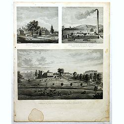
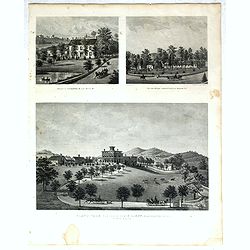
Mount Vernon Valley Residence of S.J. Powers / Borden condensed milk factory brewsters N.Y / Residence of Dan D. Chamberlain South East Putman Co. N.Y.
Three heliographic prints on one sheet : "Mount Vernon Valley Residence of S.J. Powers (135 x 155mm.) / Borden condensed milk factory brewsters N.Y (135 x 155mm.) / ...
- $100 / ≈ €94
Place & Date: New York,1867
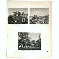
"Old Dutch church, "Sleepy Hollow" / Residence of A.B Baylis esq Bedford village N.Y / "Sunny side" former residence of Washington Irving."
Three heliographic prints on one sheet : "Old Dutch church, "Sleepy Hollow" / Residence of A.B Baylis esq Bedford village N.Y / "Sunny side" form...
- $100 / ≈ €94
Place & Date: New York,1867
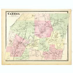
Town of Carmel.
Fine lithographed map of the town of Carmel. From : "Atlas of New York and vicinity" published by Beers, Ellis & Soule, 95 Maiden Lane, New York. The map pr...
Place & Date: New York, 1867
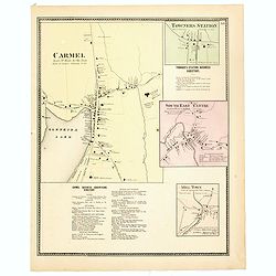
Town of Carmel / Towners Station / South East Centre / Mill Town.
Fine lithographed map of the town of Carmel / Towners Station / South East Centre / Mill Town. From "Atlas of New York and vicinity" published by Beers, Ellis ...
Place & Date: New York, 1867
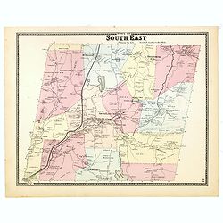
Town of South East.
Fine lithographed map of the town of South East. From : "Atlas of New York and vicinity" published by Beers, Ellis & Soule, 95 Maiden Lane, New York.The map...
Place & Date: New York, 1867
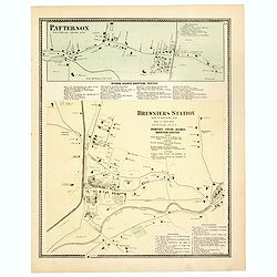
Town of Patterson / Brewsters Station.
Fine lithographed map of the town of Patterson / Brewsters Station. From : "Atlas of New York and vicinity" published by Beers, Ellis & Soule, 95 Maiden Lan...
Place & Date: New York, 1867
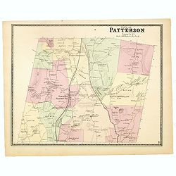
Town of Patterson.
Fine lithographed map of the town of Patterson. From : "Atlas of New York and vicinity" published by Beers, Ellis & Soule, 95 Maiden Lane, New York.The map ...
Place & Date: New York, 1867
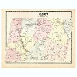
Town of Kent.
Fine lithographed map of the town of Kent. From :"Atlas of New York and vicinity" published by Beers, Ellis & Soule, 95 Maiden Lane, New York.The map provid...
Place & Date: New York, 1867
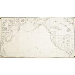
North Pacific.
Huge three sheet so-called Blue-back sailing chart of the Northern Pacific including China, Korea (with Matu Is. and Liancourt), Japan, Philippines, Kamchatka, Hawaii, Al...
Place & Date: London, 1868

Plano de la Hacienda de Juana de Oro.
Wall-map sized map in 2 sheets, if joined 940 x 1300mm., showing the Hacienda (farm) of Juana de Oro in Ecuador. The cocoa farm was owned by Mrs. Leonor Carbo of Higgins ...
- $500 / ≈ €468
Place & Date: Guayaquil ( Equateur), 1868
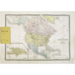
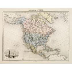
Carte de L'Amérique du Nord. . .
Detailed map of Nord America and Central America giving good detail along the east coast and the Lakes. Including San Francisco, Monterey, etc.With inset map of Dominican...
- $250 / ≈ €234
Place & Date: Paris, 1870
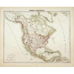
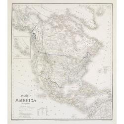
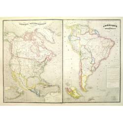
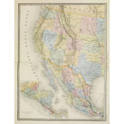
Nord-America
Large and detailed map of North and Central America. With inset key to the different possessions, Republic of Mexico, - Central America, States and territories.Lithograph...
- $150 / ≈ €140
Place & Date: Berlin, 1872
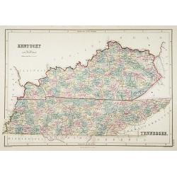
Kentucky.
A detailed lithographed map of Kentucky. Published by Adam (1784-1874) and Charles Black, publishers active in Edinburgh.
- $100 / ≈ €94
Place & Date: Edinburg, 1874
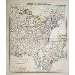
Östliches Nordamerica. . .
Large and detailed map of North America. With inset map lower right of ""Die Nordöstlichen Staten"". With color key in lower left.The map is prepared...
- $200 / ≈ €187
Place & Date: Weimar 1874
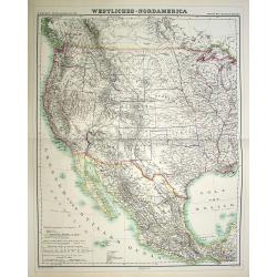
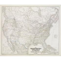
Westliches-Nordamerica.
Large and detailed map of North America. With color key in lower left.The map is prepared by H.Kiepert and published in Berlin by Dietrich Reimer. Engraved by C.L.Ohmann.
- $200 / ≈ €187
Place & Date: Weimar, 1874
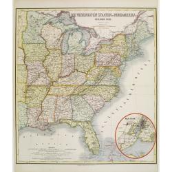
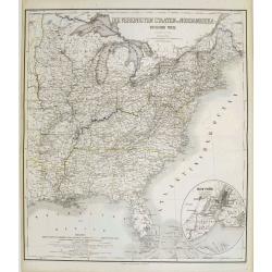
Die Vereinigten Staten von Nordamerika (Ostlicher theil).
Detailed map of eastern part of the United states. In lower right hand corner inset map of New York Bay, including, NY, Newark, Staten Island.The map is prepared by C.Gr�...
- $450 / ≈ €421
Place & Date: Weimar, 1874
Die Vereinigten Staten von Nordamerika (Ostlicher theil).
Detailed map of eastern part of the United states until the border of Texas. In lower right hand corner inset map of New York Bay, including, NY, Newark, Staten Island.Th...
- $450 / ≈ €421
Place & Date: Weimar, 1874
Amérique du Nord.
Decorative map of Northern America from Géographie Universelle, Atlas Migeon. published by J. Migeon. Nice engraving at the lower left hand of New York with the Statue o...
- $125 / ≈ €117
Place & Date: Paris, 1874
Die Vereinigten Staten von Nordamerika nebst Canada.
Large and very detailed German map issued prior to the outbreak of the Civil War. It covers the United States with parts of Canada and Mexico. The states and territories ...
- $400 / ≈ €374
Place & Date: Weimar, 1874
Nord America mit Westindien.
Detailed map of North America. With a color key indicating US, English, French, Dutch, Spanish, Portuguese, Danish possessions in the region with original outline color d...
- $300 / ≈ €281
Place & Date: Weimar, 1874

City of Boston.
A handsome mid 19th century panoramic view of the city of Boston as seen from the southern part of it's harbor. Many monuments are clearly visible, including the State Ho...
- $250 / ≈ €234
Place & Date: New York, 1872-1874
Etats-Unis.
Decorative map of the United States from Géographie Universelle, Atlas Migeon. Oklahoma is Indian Territory with Public Lands in the panhandle. With an engraving lower l...
- $75 / ≈ €70
Place & Date: Paris, 1874
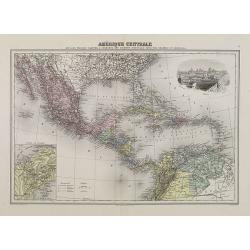
Amérique Centrale.
Decorative map of Central America from Géographie Universelle, Atlas Migeon. With an inset map of the Isthmus of Panama lower left corner and a panoramic view of Mexico ...
Place & Date: Paris, 1874
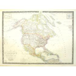
Nouvelle carte de l'Amérique Septentrionale et des iles qui en dépendent dressée par H. Brué. . .
Very large, highly detailed, and uncommon issue of the map of North and Central America (ca. 1:13,888,000) prepared by H. Brué and improved by A.Vuillemin. Showing main ...
- $500 / ≈ €468
Place & Date: Paris, 1875
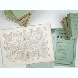
Histoire de la Guerre Civile en Amerique par M. Le Comte de Paris, Ancien Aide de Camp du General Mac Clellan (McClellan). ...
These 30 maps were made by Vorzet to accompany Louis Phillipe d'Orleans' (Comte de Paris) multi volume "Histoire de la Guerre Civile en Amérique". The set incl...
Place & Date: Paris. Michel Levy Freres, 1875

New York Ferry Boat. (Bac à vapeur de New York).
A very decorative print showing the New York Ferry Boat "Fulton," published by Currier & Ives. The Ferry boat "Fulton" sails to the right. A singl...
Place & Date: New York, ca. 1875
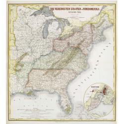
Die Vereinigten Staaten von Nordamerika (Ostlicher theil).
This is a 1876 example of C. Graf's map of the United States of America. The map covers the eastern part of the United States from eastern Texas to the Atlantic, extendin...
- $300 / ≈ €281
Place & Date: Weimar, 1876
Amérique septentrionale dressée par C.V. Monin. . . / Amérique méridionale. . .
Two maps on one sheet. North America to the left, shows major cities, political divisions, and areas of Indian habitation for North America and the West Indies and state ...
- $300 / ≈ €281
Place & Date: Paris, c.1876
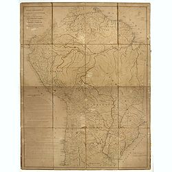
Mapa geogra´fico de la mayor parte de la Ame´rica Meridional que contiene los paises por donde debe trazarse la li´nia divisoria que divida los dominios de Espan~a y Portugal. . .
Rare first edition of the map drawn by Francisco Requena (1743-1824) after his expedition to the Amazon in order to delineate the boundary between the Spanish and Portugu...
Place & Date: Bourquin, F. Philadelphia, ca. 1876
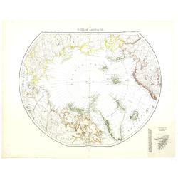
Région arctique.
Decorative map of the North Pole, prepared by Louis Vivien de Saint-Martin (* 22. Mai 1802 in Saint-Martin de Fontenay, died 3 January 1897 in Paris). He was one of the m...
Place & Date: Paris, Hachette, 1877
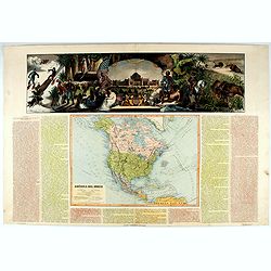
América del Norte.
Very attractive large map of North America with stunning panorama at top of figures representing the continents, etc. A rare and decorative map. From "Atlas geográf...
- $550 / ≈ €515
Place & Date: Madrid, 1877
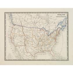
États-Unis et Nouvelle Bretagne.
Detailed map of the United States. All different States are divided by an orange border line.
- $120 / ≈ €112
Place & Date: Paris, 1880

Dutton Map of the Grand Canyon, Arizona (in 4 joined sheets)
An important 1882 map of the Grand Canyon, Arizona, published in "Atlas To Accompany The Monograph On The Tertiary History Of The Grand Canon District By Capt. Clare...
- $1000 / ≈ €936
Place & Date: Julius Bien & Co., 1882
Driving chart of Hartford and vicinity : 15 miles around.
Road map by Albert A. Hyde & Co. of Hartford and vicinity, with the Connecticut River in the center. Published by Albert A. Hyde & Co., in New York and lithograph...
Place & Date: New York / Philadelphia, 1884

Carte générale de la République Argentine dressée d'après les données les plus récentes.
An UpToDate map of the Argentinian Republic published in Basel by "le Bureau Officiel d'Information de la République Argentine". Detailed map of Argentina show...
- $350 / ≈ €328
Place & Date: Basel, 1887
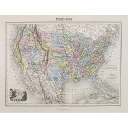
Etats Unis (Etats de l' Ouest).
Large format highly detailed map of the states and territories of the West, with Central America, included in a large inset titled "Etats de l'Amerique Centrale"...
- $400 / ≈ €374
Place & Date: Paris, 1889
![Canada Creek Falls . . [title in French, English, German & Latin] N°32. Pl. 4.](/uploads/cache/26800-250x250.jpg)
Canada Creek Falls . . [title in French, English, German & Latin] N°32. Pl. 4.
A view of the Canada Creek Falls.From 8e Livraison Amérique Septentrionale - Etat de New York. After Jacques Milbert and lithographed by Dupressoir and figures by V. Ada...
Place & Date: Paris, Bove dirigée par Nöel ainé & Cie, 1892

Mexico.
Decorative territorial map showing the Southwest of the United States with Mexico, Baja California and the neighboring states Arizona, New Mexico and Texas. The map exten...
- $200 / ≈ €187
Place & Date: Glogau, 1892
![[South America].](/uploads/cache/46140-250x250.jpg)
[South America].
Alexey Afinogenovich Ilyin was a lieutenant general and cartographer (1832-1889). In 1856, after graduating from the Academy of the General Staff, he was at the military ...
- $100 / ≈ €94
Place & Date: St. Petersburg, 1899
![[North America].](/uploads/cache/46142-250x250.jpg)
[North America].
Alexey Afinogenovich Ilyin was a lieutenant general and cartographer (1832-1889). In 1856, after graduating from the Academy of the General Staff, he was at the military ...
- $150 / ≈ €140
Place & Date: St. Petersburg, 1899

S America by Mas T.J. Sackels.
Pen and ink on card board. Map of South America drawn by T.J.Shackels. Probably a school exercise.
- $120 / ≈ €112
Place & Date: England, ca. 1900
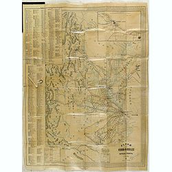
Plano de los Ferro-Carriles de Republica Argentina 1902.
Folding rail road map of Argentina, with inset of Buenos Aires in upper right corner.
Place & Date: Buenos Aires, ca. 1902
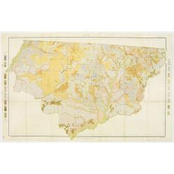
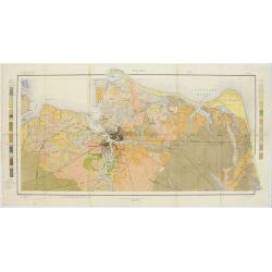
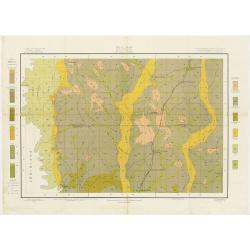
Soil map - Florida, Gadsden County sheet.
Early color lithographed soil map by Julius Bien & Co. in New York for the Department of Agriculture. Legends at the side give detail on soil type, etc. They also inc...
- $40 / ≈ €37
Place & Date: New York, 1903
Soil map - South Carolina Campobello Sheet.
Early color lithographed soil map by Julius Bien & Co. in New York for the Department of Agriculture. Legends at the side give detail on soil type, etc. They also inc...
- $50 / ≈ €47
Place & Date: New York, 1903
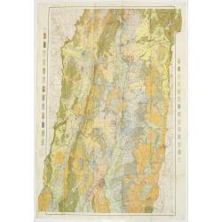
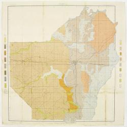
Soil map - Virginia Norfolk Sheet.
Soil map printed by Julius Bien & Co. in New York for the Department of Agriculture. The map gives great detail of the area centered on Norfolk, Potsmouth, Chesapeake...
- $50 / ≈ €47
Place & Date: New York 1903
![[Soil map] Virginia-Maryland-West Virginia, Leesburg sheet.](/uploads/cache/23257-250x250.jpg)
[Soil map] Virginia-Maryland-West Virginia, Leesburg sheet.
Early color lithographed soil map by Julius Bien & Co. in New York for Department of Agriculture. Legends at side give detail on soil type, etc. They also include int...
Place & Date: New York, 1903

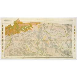
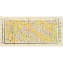
Soil map - Pennsylvania, Lockhaven sheet.
Early color lithographed soil map by Julius Bien & Co. in New York for Department of Agriculture. Legends at side give detail on soil type, etc. They also include int...
- $50 / ≈ €47
Place & Date: New York, 1903
Soil map - Connecticut. - Massachusetts, (Hartford) Springfield sheet.
Early color lithographed soil map by Julius Bien & Co. in New York for Department of Agriculture. Legends at side give detail on soil type, etc. They also include int...
Place & Date: New York, 1903
Selling price: $85
Sold in 2008
Soil map - Texas, Nacogdoches sheet.
Early color lithographed soil map by Julius Bien & Co. in New York for Department of Agriculture. Legends at side give detail on soil type, etc. They also include int...
- $75 / ≈ €70
Place & Date: New York, 1903
Soil map - Georgia, Fort Valley sheet.
Early color lithographed soil map by Julius Bien & Co. in New York for Department of Agriculture. Legends at side give detail on soil type, etc. They also include in...
- $50 / ≈ €47
Place & Date: New York, 1903
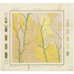
Soil map - Mississippi, McNeill sheet.
Soil map printed by Julius Bien & Co in New York for Department of Agriculture. The map is giving great detail of the area McNeill, Mississippi, in the year 1903. Soi...
- $50 / ≈ €47
Place & Date: New York, 1903
Soil map - Louisiana, Ouachita sheet.
Early color lithographed soil map by Julius Bien & Co. in New York for Department of Agriculture. Legends at side give detail on soil type, etc. They also include int...
- $40 / ≈ €37
Place & Date: New York, 1903
![[United States map with Ottoman script.]](/uploads/cache/44314-250x250.jpg)
[United States map with Ottoman script.]
Postcard size map in Ottoman script showing the United States prepared by Mehmet EŞREF in a small atlas : عمومولاياةىشهانيىحاوىكوچكاطلاس [...
- $175 / ≈ €164
Place & Date: Istanbul, 1325 or 1909
![[Mexico map with Ottoman script]](/uploads/cache/44321-250x250.jpg)
[Mexico map with Ottoman script]
Postcard size map in Ottoman script showing Mexico, including Texas prepared by Mehmet EŞREF in a small atlas : عمومولاياةىشهانيىحاوىكوچكاطل...
- $150 / ≈ €140
Place & Date: Istanbul, 1325 or 1909
![[ North and South America with telegraph cables, with Ottoman script]](/uploads/cache/44330-250x250.jpg)
[ North and South America with telegraph cables, with Ottoman script]
Postcard size map showing North and South America with telegraph cables. The map is in Ottoman Arabic-script prepared by Mehmet EŞREF in a small atlas : عمومولا�...
- $190 / ≈ €178
Place & Date: Istanbul, 1325 or 1909
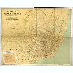
Mappa do estado de Minas Geraes.
Monumental map of the Minas Geraes State, the Brazilian Eldorado, with an inset plan of Belo Horizonte. Scale of 1 : 100 000. Lith. Hartmann-Reichenbach, 1910. Organized ...
- $1000 / ≈ €936
Place & Date: Rio de Janeiro, 1910 -1911
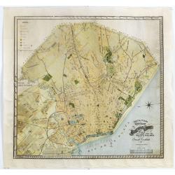
Nuevo plano de la ciudad de Buenos Aires y parte del partido de avellaneda . . .
A rare detailed city plan of Buenos Aires prepared in 1912 by Ernesto Escalante. The plan depicts the city from the Partido de Avellaneda and the Villa Riachuelo to the R...
Place & Date: Buenos Aires, 1912
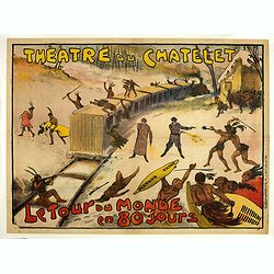
Théâtre du Châtelet. Le Tour du Monde en 80 jours. (The attack of the train).
Theatre poster for "Around the World in Eighty Days by A. Dennery and Jules Verne, for Théâtre du Châtelet, Paris. Printed by : Imprimerie Ch. Wall et Cie, 14 rue...
- $1200 / ≈ €1123
Place & Date: Paris, Imp. Ch. Wall et Cie, ca.1900-1914
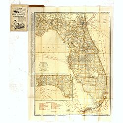
Rand Mc.Nally indexed pocket map Tourits' and Shipper' Guide of Florida. . .
This fine pocket map has on both side a map of Florida. Folding color map (approximately 640 x 495mm) is titled "Rand McNally standard map of Florida" and one h...
Place & Date: Chicago & New York, ca.1915
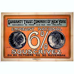
Guaranty Trust Company of New York. Emprunt national 6%.n Souscrivez.
Very decorative propaganda poster with design by Mark All of Paris for "Guaranty Trust Company of New York", a JPMorgan Chase predecessor in order to promote th...
Place & Date: Paris, 1918

Accion de 10 pesos. No. 110,930 (Share certificate)
Beautifully engraved certificate from the "Compania Azucarera de Paraiso Novillero S.A. Republica Mexicana", share certificate No.110,930 for one share, in a $ ...
- $30 / ≈ €28
Place & Date: Paris, 1924
![[Map of the Monterey Peninsula.]](/uploads/cache/48349-250x250.jpg)
[Map of the Monterey Peninsula.]
A lovely example of Jo Mora's Del Monte Properties Company' California's Fun' playground tourist map of the Monterey Peninsular, published in San Francisco in 1927. The r...
- $900 / ≈ €842
Place & Date: San Francisco, 1927

Cidade do Rio de Janeiro - Remodelação, Extensão e Embelezamento.
Important architectural book prepared by Antonio Prado Junior (1880-1955) under the general direction of Alfredo Agache ( 1875-1959) published by Foyer Brésilien editor,...
- $1100 / ≈ €1029
Place & Date: Foyer Brésilien editor, Paris, 1930
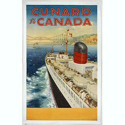
Cunard to Canada.
Poster by Charles Eddowes Turner for Cunard lines. The poster shows The NEW SYLVANIA, one of the four new 22,000 - ton Cunarders which are the largest ever built for serv...
Place & Date: England, ca. 1930
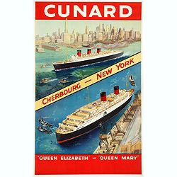
Cunard Cherbourg-New York.
Original vintage Cunard luxury cruise liner travel poster advertising Cunard Europe to all America fastest ocean service in the world. Stunning design featuring two color...
Place & Date: England, ca. 1930
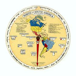
North and South America At-A-Glance.
A clever device for demonstrating the statistics of each country, the Area, Population, Population per Sq. Mile, Highest Elevation, Principal River, Currency, Capital, Fo...
Place & Date: New York & London: International At-A-Glance Chart Co. 1931
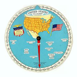
United States At-A-Glance.
A clever device for demonstrating the statistics of each state, the Area, Population, Highest Elevation, Principal River, Capital, railroad Mileage, Date Entered Union, P...
Place & Date: New York & London: International At-A-Glance Chart Co. 1931
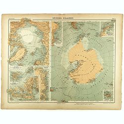
Régions Polaires.
Eight maps on one sheet, showing the North and South Poles, with adjective regions. Taken from "Atlas Universel" by Chesneau and Ch. Bonnesseur. Engraved by R. ...
- $50 / ≈ €47
Place & Date: Paris, 1931
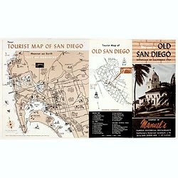
Welcome to old San Diego, birthplace of California 1769.
Publicity leaflet for "Manuel's Restauranté" in the Casa de Pedrorena. On one side a pictorial map of San Diego and "Tourist Map of Old San Diego", w...
- $75 / ≈ €70
Place & Date: San Diego, ca. 1935
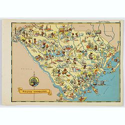
South Carolina.
A fun, humorous, whimsical map of South Carolina by Ruth Taylor White. With vibrant colors.The state is filled with delightful cartoonish characters, some pursuing assort...
- $125 / ≈ €117
Place & Date: Boston, ca 1935