Search Listings matching "cassini" in America
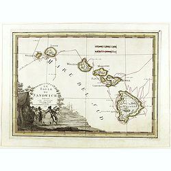
Le Isole di Sandwich delineate sulle osservazioni del Cap Cook.
FIRST EDITION on laid paper. Cassini’s splendid map depicts Sandwich islands, old name for Hawaii islands, at the end of the eighteenth century. The splendid cartouche ...
Place & Date: Rome, 1798
![Le Isole di Sandwich delineate sulle osservazioni del Cap Cook. [Hawaii]](/uploads/cache/43195-250x250.jpg)
Le Isole di Sandwich delineate sulle osservazioni del Cap Cook. [Hawaii]
FIRST EDITION on laid paper. Cassini’s splendid map depicts Sandwich islands, old name for Hawaii islands, at the end of the eighteenth century. The splendid cartouche ...
Place & Date: Rome, 1798
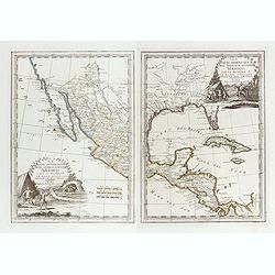
La parte orientale dell' antico.. messico con la Florida..
A splendid two-sheet map of Mexico, including California, Arizona, New Mexico, part of Texas, Baja California and Mexico (west part) and of the Southeast Part of the US, ...
Place & Date: Rome, Calcography, 1797-before 1839
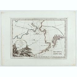
Le Coste Nord Ovest Dell'America e Nord Est dell'Asia Delineate sulle ultime Osservazioni del Cap. Cook
Cassini’s splendid early map of Cook's exploration of the Bering Strait, made on his Third and final voyage. The title is within a decorative title cartouche depicting ...
Place & Date: Rome, Calcography, 1798-before 1839