Search Listings matching "sea-chart" in Africa > Central Africa
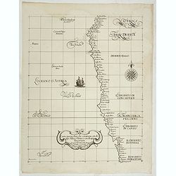
Carta particolare che comincia con il c.apo Aldea è Finisce con il capo Degortam. . .
Dudley’s magnificent chart shows the south west coast of Africa with the Tropic of Capricorn, located at about 23.5 degrees south. A first edition without the privilege...
Place & Date: Florence, 1645
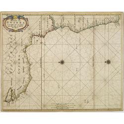
Pas-Caart van Guinea en den Custen daer aen gelegen Van C..
A decorative chart of the southwest coast of Africa, embellished with an elaborate, finely colored title-cartouche, and 2 compass-roses. Pieter Goos (ca. 1616-1675) was o...
Place & Date: Amsterdam, 1666
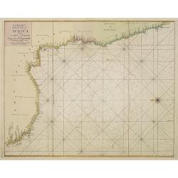
A chart of the coast of Africa from Cape Virde to Cape Bona Esperansa.
Rare and attractive chart of the western part of Africa.
- $800 / ≈ €704
Place & Date: London, 1748
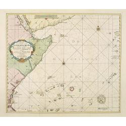
Pas-Kaat vaneen gedeelte van de Aethiopische Zee behelsende de Kusten Zanguebar, Ajan en Abex, en een gedeelte van de Arabische Kust. . .
A finely engraved and detailed chart of the most eastern tip of Africa, including Somalia, Djibouti, Yemen, Mauritius, and many other islands in the Indian Ocean.Very rar...
Place & Date: Amsterdam, 1753
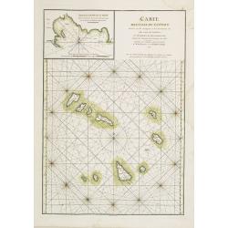
Carte des Iles du Cap-Verd Dressée sur les remarques et les observations les plus exactes des Navigateurs.
French sea chart of the Cap Verde Islands, situated 570 kilometers off the coast of Western Africa.Latitude and longitude scales, compass rose and system of rhumb lines, ...
- $100 / ≈ €88
Place & Date: Paris, Brest, chez Demonville, 1775