Browse Listings
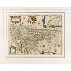
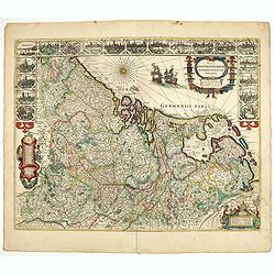
Hollandia Comitatus.
Orientated west to the top of the sheet, this presents the County of Holland in the classical orientation for seventeenth century maps, with Amsterdam at the center. The ...
Place & Date: Amsterdam, 1647
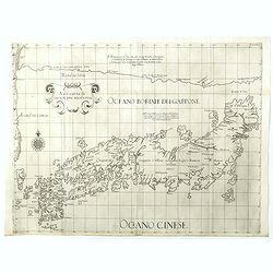
Asia carta di ciasete piu moderna. (Japan)
Rare FIRST STATE of this important map for Korea and Japan map of the Blancus/Moreira type, but adds a huge 'Jesso' filling the top of this old map. The map is of interes...
Place & Date: Florence, 1646-1647
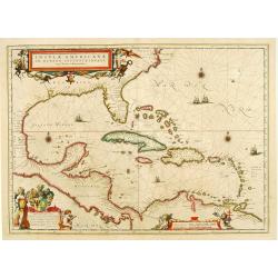
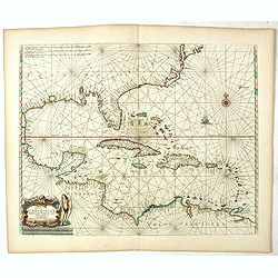
Insulae Americanae in Oceanus Septentrionali cum Terris..
General map of the West Indies extending from Virginia to the mouth of the Orinoco, and destined to be copied in various shapes by many other publishers. Title cartouche ...
Place & Date: Amsterdam, 1647
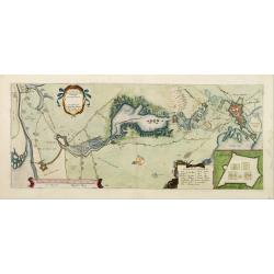
Tabula Bergarum ad Zomam Stenbergae et novorum ibi operum.
The map gives an outline of the Scheldt from Bergen op Zoom to Antwerp, with all the ramparts built between 1622 and 1627.
Place & Date: Amsterdam, 1647
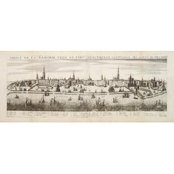
Profil de la renomée ville et port d'Emstredam cappitalle des estats de Hollande.
Extremely rare panoramic town-view of Amsterdam seen from the river IJ.Exceptional bright, sharp example.The print is skillful copy of the print of Matthieu Merian, now w...
Place & Date: Paris, 1647
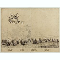
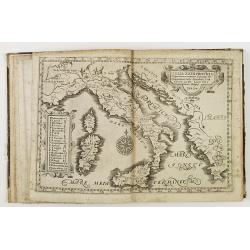
Quartum Praelium Coniovian inter et Fluvium Rio Grande XVII Ian
Decorative engraving of the fourth sea battle with the Portuguese fleet offshore at the Rio Grande, in1640. Engraved by J. van Brosterhuyzen after a design by Frans J. Po...
Place & Date: Joannes Blaeu, Amsterdam 1647
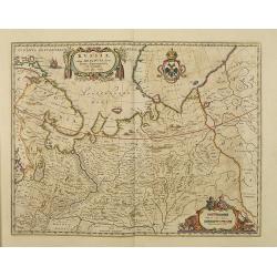
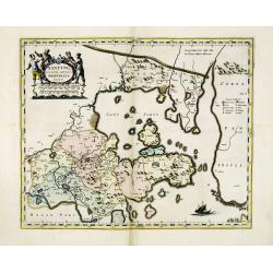
Russiae vulgo Moscovia dictae, Partes Septentrionalis et orientalis.
In the north the Murmansk Sea. Including the western coast of Nova Zembla. Title cartouche and two cartouches, the bottom right one showing two hunters, bears, stags etc....
Place & Date: Amsterdam, 1647
![[Two vomlumes, with two Leo maps] De Bello Belgico, Decas Prima / Decas Secunda.](/uploads/cache/48779-250x250.jpg)
[Two vomlumes, with two Leo maps] De Bello Belgico, Decas Prima / Decas Secunda.
With 2 engraved titles of the 'Leo Belgicus', with one paw resting on a shield bearing the title, large woodcut printer's device on the colophons, and 30 richly engraved ...
Place & Date: Rome, Franciscus Corbelletus, 1632-1647
Curia Hollandiae Interior. (Binnenhof)
The government center of the Netherlands is situated in and around the Binnenhof-Buitenhof in The Hague. In 1248 the Roman king Willem II built a castle here and named it...
Place & Date: Amsterdam, 1649
Chorographica descriptio provinciarum, et conventum fratrum minorum S. Francisci Capucinorum...
All maps are good and dark impressions. Several maps with slight foxing and browning, the folding map with 2 splits (top right part 10 cm and lower left part 6 cm into en...
Place & Date: Turin, 1649
![[ The repositioning of the Vatican obelisk ]](/uploads/cache/49045-250x250.jpg)
[ The repositioning of the Vatican obelisk ]
Joan Blaeu published The Repositioning of the Vatican Obelisk. This large engraving on multiple sheets and in beautiful original colors is based on Domenico Fontana’s d...
Place & Date: Amsterdam, 1649
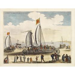
Currus Veliferi Illmi. Pr. Mauritii Nassouvii. (Prince Maurits' sailing-carriage, designed by Simon Stevin. )
Prince Maurits' sailing carriages had been designed by Simon Stevin. The Prince, always accessible to new inventions of his old instructor, could not please the foreign a...
Place & Date: Amsterdam, 1649
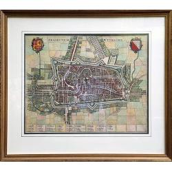
Traiectum Wttrecht
Fine plan of Utrecht from the townbooks "Novum Ac Magnum Theatrum Urbium Belgicae Liberae Ac Foederatae".FRAMED : Additional shipping costs apply. The item is l...
Place & Date: Amsterdam, 1649
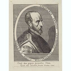
Abrahamus Ortelius Antuerpianus cosmographus natus a. MDXXVII
Portrait of Abraham Ortelius (Abraham Ortel), famous cartographer born in Antwerp and after studying Greek, Latin and mathematics set up a business there with his sister,...
Place & Date: Antwerp, c.1650
Selling price: $225
Sold in 2023
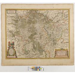
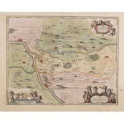
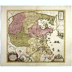
Hassia Landgraviatus.
Centered on the town of Kassel.
Place & Date: Amsterdam, 1650
![[Title page from Theatrum orbis Terrarum, with past-on]](/uploads/cache/43860-250x250.jpg)
[Title page from Theatrum orbis Terrarum, with past-on]
The frontispiece of the third part of the 'Theatrum', by Johan Blaeu. Heightened with goldDecorated with terrestrial and celestial globes and to the left Ptolemy (with sp...
Place & Date: Amsterdam, ca. 1650
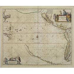
Mar del Zur, Hispanis Mare Pacificum.
Janssonius' fine chart of the Pacific including the west coast of America with California shown as an island, Japan and a small Australian coastline. This is the earliest...
Place & Date: Amsterdam, 1650
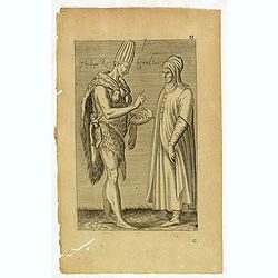
Femme Persienne. (59)
Sought-after copper engraved plate of a woman from Persia. Plate from Laonikos Chalcocondyle’s "L'histoire de la décadence de l'empire grec et establissement de c...
Place & Date: Paris, Mathieu Guillemot, 1650
(Grand dame Turque. 45)
Sought-after copper engraved plate of a woman from Turkey. Plate from Laonikos Chalcocondyle’s "L'histoire de la décadence de l'empire grec et establissement de c...
Place & Date: Paris, Mathieu Guillemot, 1650
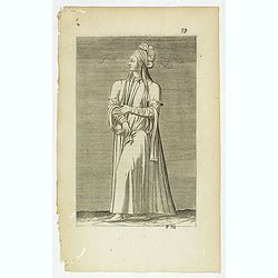
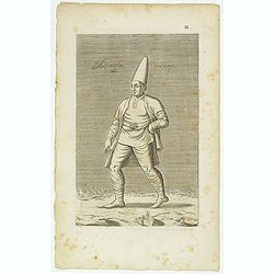
Torlaqui Religieux Turc. ( 25 )
Sought-after copper engraved plate taken from Laonikos Chalcocondyle’s "L'histoire de la décadence de l'empire grec et establissement de celuy des Turcs." by...
Place & Date: Paris, Mathieu Guillemot, 1650
Les Yurongnes. (18)
Sought-after copper engraved plate taken from Laonikos Chalcocondyle’s "L'histoire de la décadence de l'empire grec et establissement de celuy des Turcs." by...
Place & Date: Paris, Mathieu Guillemot, 1650
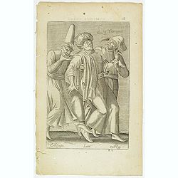
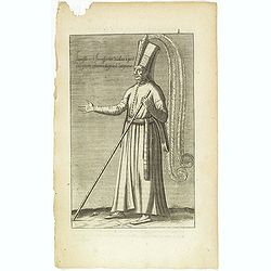
Habit et Manière ancienne des Peiches ou Laquais du Grand Seigneur. (14)
Sought-after copper engraved plate taken from Laonikos Chalcocondyle’s "L'histoire de la décadence de l'empire grec et establissement de celuy des Turcs." by...
Place & Date: Paris, Mathieu Guillemot, 1650
Peich ou Peider de Nation Persienne Laquais du Grand Seigneur. (13 )
Sought-after copper engraved plate taken from Laonikos Chalcocondyle’s "L'histoire de la décadence de l'empire grec et establissement de celuy des Turcs." by...
Place & Date: Paris, Mathieu Guillemot, 1650
Azamoglan Rustique .(12)
Sought-after copper engraved plate taken from Laonikos Chalcocondyle’s "L'histoire de la décadence de l'empire grec et establissement de celuy des Turcs." by...
Place & Date: Paris, Mathieu Guillemot, 1650
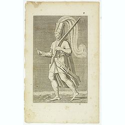
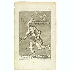
Iannissaire Allant à la Guerre. (9)
Sought-after copper engraved plate from Laonikos Chalcocondyle’s "L'histoire de la décadence de l'empire grec et establissement de celuy des Turcs." by Thoma...
Place & Date: Paris, Mathieu Guillemot, 1650
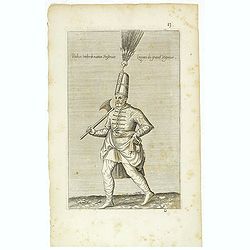
Iannissaire ou Ianissarler Soudart a Pied de la Garde Ordinaire du Grand Seigneur. (8)
Sought-after copper engraved plate from Laonikos Chalcocondyle’s "L'histoire de la décadence de l'empire grec et establissement de celuy des Turcs." by Thoma...
Place & Date: Paris, Mathieu Guillemot, 1650
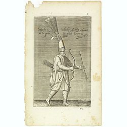
Solachi ou Solacler, Archer Ordinaire de la Garde du Grand Seigneur. (7)
Sought-after copper engraved plate taken from Laonikos Chalcocondyle’s "L'histoire de la décadence de l'empire grec et establissement de celuy des Turcs." by...
Place & Date: Paris, Mathieu Guillemot, 1650
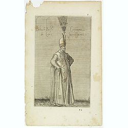
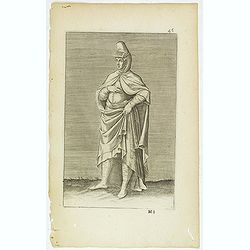
Boluch Bassi Capitaine de Cent Janissaires. (6)
Sought-after copper engraved plate from Laonikos Chalcocondyle’s "L'histoire de la décadence de l'empire grec et establissement de celuy des Turcs." by Thoma...
Place & Date: Paris, Mathieu Guillemot, 1650
![[Title page for ] Atlas de la Terre ou Monde Terrestre - Tome premier]](/uploads/cache/47761-250x250.jpg)
[Title page for ] Atlas de la Terre ou Monde Terrestre - Tome premier]
Title page of " Atlas de la Terre ou Monde Terrestre - Tome premier" by J. Jansonius. This is the updated version of 1:42B. The figures of the king, queen, daup...
Place & Date: Amsterdam, after 1650
Le Duché d'Aiguillon Tracé Par le Sr. Du Vall.
Home of the "Cahors” This AOC is the most famous of the sub-regions and home to the popular variety Malbec. These inky wines have been adored for centuries, especi...
Place & Date: Amsterdam, 1650
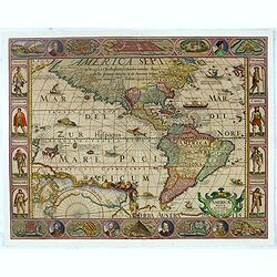
Americae Nova Descriptio.
Final state. According to Philip Burden, "this scarce map is America's first single-sheet map with decorative borders." A re-issue of the 1614 plate by Pieter v...
Place & Date: Amsterdam, 1652
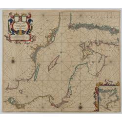
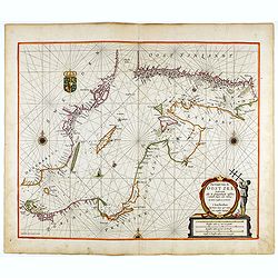
Oost Zee door Arnold Colom.
Large double-page engraved chart of the Baltic Sea, including the coastlines of Finland, Estonia, Latvia, Lithuania, Poland, Denmark, and Sweden, with a decorative inset ...
Place & Date: Amsterdam, c. 1654
![Les Isles Philippines [on sheet with] Islas de los Ladrones ou Isle des Larrons.](/uploads/cache/42023-250x250.jpg)
Les Isles Philippines [on sheet with] Islas de los Ladrones ou Isle des Larrons.
Sanson's important mid-seventeenth-century map of the Philippines and tha Ladrones.It was first engraved by J. Somer for the elder Nicolas Sanson with a privilege for twe...
Place & Date: Amsterdam/Utrecht, 1654
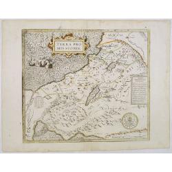
Terra Promissions.
A beautifully executed and very rare map of the Promised Land, divided into the 12 Tribes. The shore line runs in north-southwesterly direction from Sidon as far as Pelus...
Place & Date: Paris, c.1655
-250x250.jpg)
Vues du port de Llivourne. (set of 6 prints)
Sought-after complete suite of 6 engravings by S[tefano] Della Bella [1610-1664]. in a second state (of 2).Della Bella was born in Florence in 1610, and studied the art ...
Place & Date: 1654-1655
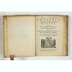
Tweevoudigh onderwiis van de Hemelsche en Aerdsche Globen; Het een Na de meyning van Ptolemeus met een vasten Aerdkloot...
Tweevoudigh onderwiis van de Hemelsche en Aerdsche Globen; Het een Na de meyning van Ptolemeus met een vasten Aerdkloot; Het ander Na de Natuerlijcke stelling van N. Cope...
Place & Date: Amsterdam, 1655
(China Atlas) Novus Atlas Sinensis, A Matino Martinio... Seste Deel van de Nieuwe Atlas, oft Toonneel des Aerdrijck, Uytgegeven door Joan Blaeu.
Dutch text edition of the First European Atlas of China. 17 engraved maps in original hand-color, and engraved title pages in original hand-color, heightened in gold. [6]...
Place & Date: Amsterdam, 1655
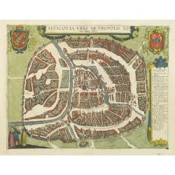
Moscovia urbs Metropolis totius Russiae Albae.
Detailed bird's-eye town-plan of Moscow from Janssonius' rare townbook. With a key (1-20) to important spots in town. The verso has French text and originates from Jansso...
Place & Date: Amsterdam, 1657
![Mexico, Regia et Celebris Hispaniae Novae Civitas ... [on sheet with] Cusco, Regni Peru in Novo Orbe Caput.](/uploads/cache/29013-250x250.jpg)
Mexico, Regia et Celebris Hispaniae Novae Civitas ... [on sheet with] Cusco, Regni Peru in Novo Orbe Caput.
Two bird's-eye views on one sheet: Mexico and Cusco.Showing Mexico City and Cusco, the capital cities of the Aztecs and Incas, with the major buildings shown in profile w...
Place & Date: Amsterdam, 1657
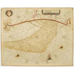
Pascaerte van Brazil en Nieu Nederlandt van Cuorvo en Flores.
A rare chart of the Atlantic Ocean from the first edition of Hendrick Doncker's Zee-Atlas, of which no surviving example is known.Although the idea of its unusual coverag...
Place & Date: Amsterdam, 1658
Tabula Magellanica.
A map with Willem Blaeu's signature, but published by his son Joan, of South America's extremity with the Strait of Magellan and Le Maire Strait.The coastlines are depict...
Place & Date: Amsterdam, 1658
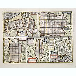
De Zype. / Purmer / Wormer/ Beemster / Waterland.
Five maps on one sheet. Showing the polders of De Zype, De Purmer, De Wormer, De Beemster and a map of Waterland, including de Bylmermeer and Monnekedam. Showing the Noor...
Place & Date: Amsterdam, 1652-1658

Turcicum Imperium.
A very handsome map with a particularly fine cartouche showing the Turkish Sultan on his throne and allegorical figures at either side brandishing weapons. At right is a ...
Place & Date: Amsterdam, 1658
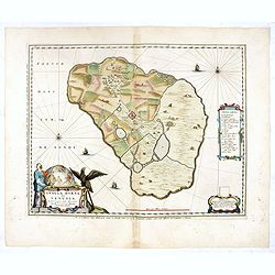
Insula Huaena sive Venusia a Guiljelmo Blaeu cum sub Tychone Astronomiae operam daret, delineata.
Decorative map of the island Hvan in the Danish Sound. In the center Tycho Brahe's famous observatory Uraniborg established in 1576, under the patronage of Frederick II, ...
Place & Date: Amsterdam, 1659
Pascaerte vande Caribische Eylanden, vande Barbados tot aende Bocht van Mexico ‘t Amsterdam By Hendrick Doncker. . .
First state. Rare. “This chart appeared in the first edition of Hendrick Doncker’s Zee-Atlas, of which no surviving example is known” -- Burden. This is an example ...
Place & Date: Amsterdam, 1659
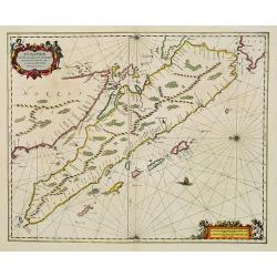
Sumatrae et insularum Locorumque nonnullorum circumiacentium. . .
Fine depicting the Island of Sumatra and the southern coasts of Malaysia from Quedo to Johore.North is orientated to the left of the page.Singapore is probably identifie...
Place & Date: Amsterdam, 1660
Pecheli, Xansi, Xantung, Honan, Nanking, In plaga Regni Sinensis. . .
A map of the northern provinces of China after the Jesuit Martino Martini, depicting of Hebei (Pecheli), Shanxi (Xansi), Shandong (Xantung), Henan (Honan), and Jangsu (Na...
Place & Date: Amsterdam, ca 1660
Xantung, sinarum imperii provincia quatra.
A map of the northern province ‘Xantung’ of China after the Jesuit Martino Martini.Shows the Great Wall and is centered on the Bohai Sea, and the Shandong and Liaonin...
Place & Date: Amsterdam, ca 1660

Situs Terrae Circulis Coelestibus circundatae..
A celestial chart showing a large globe centered on Australia and the Pacific, with California as an island, South East Asia, encircled by the zopdiacal band according to...
Place & Date: Amsterdam, Janssonius, 1660
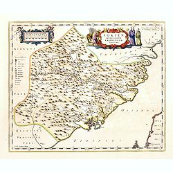
Fokien Imperii Sinarum Provincia undecima.
The province of Fokien lies opposite Taiwan and south of the region described in the above map. The coast is shown from Wen-zhou in the north to Fu-zhou and as far south ...
Place & Date: Amsterdam, 1660
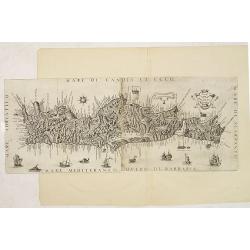
Il Regno Di Candia.
This rare map is based on the important map of Crete by Basilicata. The maps by Marco Boschini reached a wider audience than the few individuals for whom the Basilicata m...
Place & Date: Venice, 1660

De Texel Stroom .. vant Marsdiep./ Caarte van De Mase...
Two decorative charts on one sheet, one depicting Texel and the entrance of the Zuider Zee with an inset showing the north coast of West-Friesland, the other depicting th...
Place & Date: Amsterdam, 1660
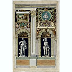
Tabula IV sequitur Farnesiana Posticus.
Ornamental representation of Temple St. Mariae in Rome by Petrus Aquila (1650-1692), after Annibale Carracci. Inscribed in the plate. "Petrus Aquila delin at sculp. ...
Place & Date: Rome, 1660
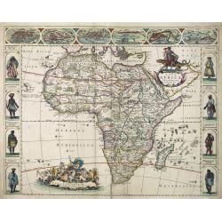
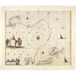
Nova Africa descriptio.
A beautifully engraved and most attractive "carte à figures"- map of the African continent. Bordered, above, by panels showing panorama's of Cairo, Alexandria,...
Place & Date: Amsterdam, after 1660
![De Texel Stroom met de gaten vant Marsdiep. [with] Caarte van De Mase ende het Goereesche Gat.](/uploads/cache/12097-250x250.jpg)
De Texel Stroom met de gaten vant Marsdiep. [with] Caarte van De Mase ende het Goereesche Gat.
Two decorative charts on one sheet, one depicting Texel and the entrance of the Zuider Zee with an inset showing the north coast of West-Friesland, the other depicting th...
Place & Date: Amsterdam, 1660
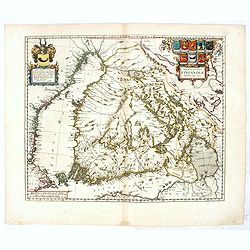
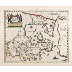
Magnus Ducatus Finlandiae Auct. Andrea Bureo Succo.
The first printed survey map of Finland, composed by the Swedish cartographer Anders Bureus (1571-1661). The map was published in 1662 in the second volume of Joan Blaeu'...
Place & Date: Amsterdam, 1660
Pascaarte, van de Zuijderzee, Vliestroom, Vlie, en Amelandergat…
Very rare chart of the Dutch Zuiderzee, here in its rare 5th state (o f6). Showing the coastlines along the Dutch inner sea. Two compass roses indicate north to the left ...
Place & Date: Amsterdam, c. 1660
Poli Arctici, et circumiacentium terrarum descriptio novissima. . .
A re-issue of the Hondius' plate. A particularly decorative map of the North Pole with Iceland. Several Dutch names in Labrador. The toponymy in Canada reflects the conti...
Place & Date: Amsterdam, 1660
![Praga. [Prague]](/uploads/cache/28442-250x250.jpg)
Praga. [Prague]
A rare panoramic of Prague with over the whole length of the lower part 3 columns of poems in Latin, Dutch and French and a numbered key 1-34 to the principal buildings ...
Place & Date: Amsterdam, 1660
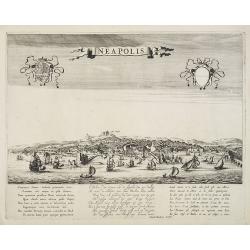
Neapolis.
A rare panoramic of Naples with over the whole length of the lower part 3 columns of poems in Latin, Dutch and French.Published by Dancker Danckerts (1634-1666).
Place & Date: Amsterdam, 1660
Xantung, sinarum imperii provincia quatra.
A map of the northern province ‘Xantung’ of China after the Jesuit Martino Martini.Shows the Great Wall and is centered on the Bohai Sea, and the Shandong and Liaonin...
Place & Date: Amsterdam, ca 1660
![[Printed on silk] Nova Totius Americae Sive Novi Orbis Tabula, Auct. Hugo Allardt.](/uploads/cache/48420-250x250.jpg)
[Printed on silk] Nova Totius Americae Sive Novi Orbis Tabula, Auct. Hugo Allardt.
Hugo Allard’s ca. 1661 map of the Americas, showing California as an island printed on silk. This separately issued map printed on paper is quite rare on the market. T...
Place & Date: Amsterdam, 1661
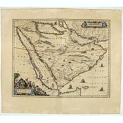
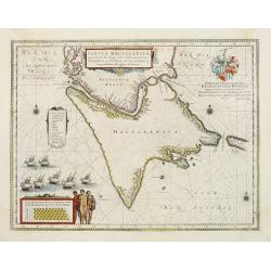
Arabia.
A handsome map of the Arabian Peninsula drawn on a large scale on which the three classical divisions are shown with some urban centers and topographical features. A cert...
Place & Date: Amsterdam, 1662
![Itroductio. [with sphere.]](/uploads/cache/23703-250x250.jpg)
Itroductio. [with sphere.]
Introduction leaf from a French text edition of Atlas Ma1or
Place & Date: Amsterdam, 1662
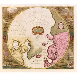
Norlandiae et quibies Gestricia et Helsingicae regiones Auct: Andrea Buraeo Sueco.
Uncommon map prepared by Anders Bure (1571-1646) with a dedicational cartouche to Gabriel Bengtsson Oxenstierna.The Atlas Maior is the epitome of decades of achievement b...
Place & Date: Amsterdam, 1662
Nova et Accuratissima Totius Terrarum Orbis Tabula.
Since its appearance as an Appendix in 1630, the atlas launched by Willem Blaeu and continued by his son Joan had expanded greatly. But despite many new regional maps the...
Place & Date: Amsterdam, 1662
Nova XVII Provinciarum Inferioris Germaniae descriptio .
Extremely rare map of the Benelux by Frederick de Widt. Originally engraved and published by P.Kaerius in 1607. In 1662 the plate came in the possession of Frederick de W...
Place & Date: Amsterdam, 1662
![[Battle of Szigetvár] Portraict de l'Armée de l'Empereur Turc Rangée en Bataille](/uploads/cache/49040-250x250.jpg)
[Battle of Szigetvár] Portraict de l'Armée de l'Empereur Turc Rangée en Bataille
An early wood block printed bird's-eye view showing the Battle of Szigetvár (Hungary). Below the wood block print is a 8-lines description in French. The battle was one ...
Place & Date: Paris, 1662
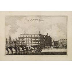
Een ander gesicht van 'T LANDTS MAGAZYN.
A decorative print of the 'T Landts Magazyn, formerly the V.O.C. warehouse and arsenal for the Admiralty of Amsterdam, now-a-days the Scheepvaartmuseum (Maritime Museum) ...
Place & Date: Amsterdam, 1663
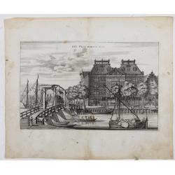
Het West Indisch Huys.
A decorative print of the West Indian House , the headquarters of the WIC, a place for meeting, trading and storage of spices and ship equipment. The maps and charts were...
Place & Date: Amsterdam, J. van Meurs, 1663
Pascaart..de Zuyder-Zee, Texel..Vlie-stroom..'t Amelander…
An eye-catching chart of the Zuiderzee with east to the top.Pieter Goos (ca. 1616-1675) was one of the most important cartographer, engraver, publisher and print seller o...
Place & Date: Amsterdam, 1666
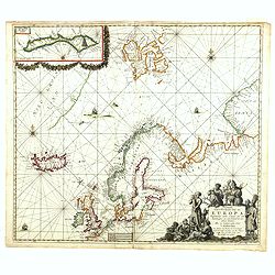
Pascarte van Europa Beginnende vande Canael tot aen Spitbergen, en van Ysland tot aen Nova Zemla . . .
An eye-catching chart of northern Europe with a coastline from northern Russia to the Dutch English Channel in the south. Good detail on Iceland. North to the top.In the ...
Place & Date: Amsterdam, after 1666
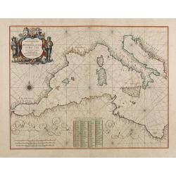
Pascaerte Van't Westelyckste der Middelandsche Zee. . .
An eye-catching chart of the western part of the Mediterranean Sea.Pieter Goos (ca. 1616-1675) was one of the most important cartographer, engraver, publisher and print s...
Place & Date: Amsterdam, 1666
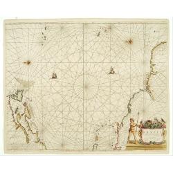
Noordoost Cust van Asia van Japan tot Nova Zembla.
Important for its early depiction of Hokkaido and the Islands to the North of Japan. Ships navigate the seas around the Siberian, Chinese and Japanese coast extending as ...
Place & Date: Amsterdam, 1666
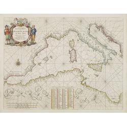
Pascaerte Van't Westelyckste der Middelandsche Zee. . .
An eye-catching chart of the western part of the Mediterranean Sea.Pieter Goos (ca. 1616-1675) was one of the most important cartographer, engraver, publisher and print s...
Place & Date: Amsterdam, 1666
Pas-Caart van de Oost Zee verthooende alle de ghelegenheydt tusschen t Eylandt Rugen ende Wyborg. . .
An eye-catching chart of the Baltic Sea. Engraved by Gerard Coeck.Pieter Goos (ca. 1616-1675) was one of the most important cartographers, engravers, publishers and print...
Place & Date: Amsterdam, 1666
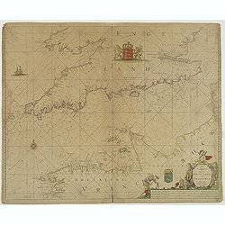
Het Canaal tusschen Engeland en Vranciick.
An eye-catching chart of the Channel.Pieter Goos (ca. 1616-1675) was one of the most important cartographers, engravers, publishers and print sellers of Amsterdam. His wi...
Place & Date: Amsterdam, after 1666
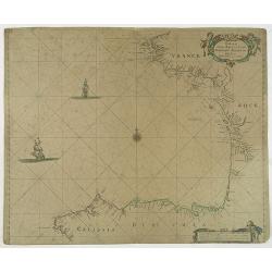
Paskaert vande Bocht van Vranckrijck Biscajen. . .
An eye-catching chart of the coast of Bretagne from Brest running south till the coast of Biscay in Northern Spain.Including the towns of Ferrol in the west, Gijon, Santa...
Place & Date: Amsterdam, after 1666
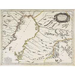
Cajanie, ou Bothnie Orientale Tirée de celles d'Andr Burae et de Isaac Massa. . .
Map of the Northern part of Gulf of Bothnia, today's border area between Sweden and Finland. The map derive from the work of the Swedish cartographer Andreas Bureus and I...
Place & Date: Paris, P.Mariette, 1666
Cust van Hollant Tussen de Maes ende Texel.
Uncommon chart of the coast of Holland, including the southern tip of Texel. East at the top. Two fine compass cards, soundings and a large Bree Veerthien offshore.Piete...
Place & Date: Amsterdam, 1666